Pollution Science 101
Cuba
Editor: Michael Ross
MonsantoInvestigation.com
-------------------------------
Section 1: Land Erosion, Plate Tectonics & Earthquakes
Section 2: Landfills & Trash
Section 3: Communism, Slavery, Politics & Environment
-------------------------------
-------------------------------
-------------------------------
-------------------------------
Section 1: Land Erosion, Plate Tectonics & Earthquakes
-------------------------------
-------------------------------
-------------------------------
-------------------------------
Powerful Earthquake Hits Between Cuba, Jamaica; Fla. Residents Feel Quake
Jan. 28, 2020
https://www.baynews9.com/fl/tampa/ap-top-news/2020/01/28/powerful-earthquake-hits-between-cuba-and-jamaica
-------------------------------
Earthquake-damaged buildings in Cuba were in “poor condition”
February 4, 2020
After
the earthquake the total collapse of a dwelling was reported, as well
as cracks and other damages in some 300 houses and in state entities
such as schools, day-care centers and agricultural facilities.
https://oncubanews.com/en/cuba/earthquake-damaged-buildings-in-cuba-were-in-poor-condition/
-------------------------------
Cubans Still Enduring Building Collapses, Lack of Safe Homes
April 21, 2014
Living in Cuba still means worrying your home or building may collapse despite reforms in 2011 to address those problems.
https://www.nbcnews.com/news/latino/cubans-still-enduring-building-collapses-lack-safe-homes-n85801
-------------------------------
Cuba Has Its Own Earthquake Challenges
April 14, 2010
HAVANA
TIMES, April 14 (IPS) — With the wounds exposed by earthquakes in
Haiti, Chile and other parts of the Americas, Cuba is beginning to focus
on its own great challenge: adapting construction for housing that can
withstand strong tremors.
“An earthquake is not just a physical
phenomenon, but also social,” according to Fernando Guasch, a researcher
with Cuba’s national seismology research centre, CENAIS. This Caribbean
island nation is one of the countries in the danger zone and has many
buildings that are highly vulnerable to the effects of temblors.
https://havanatimes.org/uncategorized/cuba-has-its-own-quake-challenges/
-------------------------------
Sinkholes appear in Cayman Islands after massive 7.7-magnitude earthquake
January 2020
Roads swallowed up after powerful tremors reported in Caribbean
https://www.independent.co.uk/news/world/americas/sinkholes-earthquake-cayman-islands-jamaica-cuba-video-evacuate-aftershock-a9307081.html
-------------------------------
List of earthquakes in Cuba
https://en.wikipedia.org/wiki/List_of_earthquakes_in_Cuba
Cuba
is located in an area with several active fault systems which produce
on average about 2000 seismic events each year. While most registered
seismic events pass unnoticed, the island has been struck by a number of
destructive earthquakes over the past four centuries, including several
major quakes with a magnitude of 7.0 or above.
Approximately 70%
of seismic activity in Cuba emanates from the Oriente fault zone,
located in the Bartlett-Cayman fault system which runs along the
south-eastern coast of Cuba and marks the tectonic boundary between the
North American Plate and the Caribbean Plate. The 12 currently active
faults in Cuba also include the Cauto-Nipe, Cochinos and Nortecubana
faults. Destructive earthquakes originating from the Oriente fault
occurred in 1766 (MI= 7.6), 1852 (MI = 7.2) and 1932 (Ms = 6.75). Some
studies suggested there is a high probability the Oriente fault would
produce a magnitude 7 earthquake, this happening in January 2020, with a
magnitude of 7.7, the highest registered in this country's history.
-------------------------------
Geology of Cuba
https://en.wikipedia.org/wiki/Geology_of_Cuba
The
geology of Cuba differs significantly from that of other Caribbean
islands because of ancient 900 million year old Precambrian Proterozoic
metamorphic rocks in the Santa Clara province and extensive Jurassic and
Cretaceous outcrops.
Western and central Cuba are a deformed
orogen, that came about due to the collision of an island arc in the
Cretaceous with the Florida-Bahamas platform. As a result, the Cuban
ophiolite zone became obducted and a northward verging fold and thrust
belt formed. A second small orogeny took place in the Paleocene and
Eocene. Eastern Cuba, southeast of the Cauto Basin, by contrast has a
Cenozoic volcanic arc complex, with ophiolites north and east of the
Sierra Maestra as Mesozoic-age orogen rocks overlain by Paleogene
sedimentary rocks and tuff. Sedimentation due to the tectonic activity
continued into the Oligocene.
Structural Geology
Pinar Del Rio Block:
Esperanze zone: Thin belt of Jurassic and Cretaceous limestone,
dolomite and evaporite in the west found in Cayo Coco and Los Remedios
zones. Deformed by thrust faulting into three nappes.
Sierra
del Rosario zone: Antiformal arrangement of three nappes with
Jurassic-Cretaceous ophiolites, siliceous slates, mafic and intermediate
lava. The Quinones subzone in the component Bahia Honda subzone
includes Maastrichtian limestone in thrust sheets. The Cinco Pesos
subzone is the south-dipping limb of the Roasario antiform.
Earthquakes
Main article: List of earthquakes in Cuba
Cuba is located in an area with several active fault systems which produce on average about 2,000 seismic events each year.[5] While most registered seismic events pass unnoticed, the island has been struck by a number of destructive earthquakes over the past four centuries, including several major quakes with a magnitude of 7.0 or above. The most recent strong earthquake occurred in 1992 when the main tremor measured 6.9 on the Richter Scale. This was followed by a magnitude 7.7 quake on January 28, 2020.
-------------------------------
Major Caribbean Earthquakes And Tsunamis A Real Risk
February 8, 2005
https://www.sciencedaily.com/releases/2005/02/050205102502.htm
Summary:
A dozen major earthquakes of magnitude 7.0 or greater have occurred in
the Caribbean near Puerto Rico, the U.S. Virgin Islands and the island
of Hispaniola, shared by Haiti and the Dominican Republic, in the past
500 years, and several have generated tsunamis. The most recent major
earthquake, a magnitude 8.1 in 1946, resulted in a tsunami that killed a
reported 1,600 people.
-------------------------------
This is why the Caribbean has not drowned yet
Mar 13, 2021
Geologists
have long thought tectonic plates move because they are pulled by the
weight of their sinking portions and that an underlying, hot, softer
layer called asthenosphere serves as a passive lubricant. But a team of
geologists at the University of Houston has found that layer is actually
flowing vigorously, moving fast enough to drive plate motions.

Geologists
Discover Powerful ‘River of Rocks’ Below Caribbean. An image of the
Earth’s warped surface of the Caribbean shows its tilted due to the
east-flowing mantle underneath the Caribbean that pushes up the western
Caribbean. In their study published in Nature Communications,
researchers from the UH College of Natural Sciences and Mathematics
looked at minute changes in satellite-detected gravitational pull within
the Caribbean and at mantle tomography images – similar to a CAT Scan –
of the asthenosphere under the Caribbean.
They found a hot
“river of rocks” being squeezed from the Pacific Ocean through a gateway
under Central America and reaching to the middle of the Caribbean Sea.
This underground “river of rocks” started flowing eight million years
ago, when the Central American gateway opened, uplifting the overlying
seafloor by several hundred feet and tilting it to the northeast toward
the Lesser Antilles.
“Without the extra support generated by this
flow in the asthenosphere, portions of Central America would still be
below sea level. The Atlantic and the Pacific Oceans would be connected
without a need for the Panama Canal,” said study co-author Lorenzo
Colli, assistant professor of geophysics, geodynamics and mantle
structure in the Department of Earth and Atmospheric Sciences.
The
findings have implications for understanding the shape of the Earth’s
surface, of its evolution over time through the appearance and
disappearance of shallows seas, low-lying land bridges and the forces
that move tectonic plates and cause earthquakes.
Another
fascinating discovery, according to the researchers, is the
asthenosphere is moving six inches per year, which is three times faster
than an average plate. It can move independently from the overlying
plates and drag them in a different direction.

“This challenges
the top-down notion that subduction is always the driver,” explained
Jonny Wu, study co-author and assistant professor of structural geology,
tectonics and mantle structure. “Think of the plates moving like an air
hockey puck and being lubricated from below. Instead, what we found is
the air hockey table is imposing its own currents on the puck that’s
moving around, creating a bottom-up movement that has not been well
recognized, and that’s being quantified here.”
Yes, this strong and fast flow of softer layer under tectonic plates is the reason why the Caribbean is still over water… [UH]
https://strangesounds.org/2021/03/this-is-why-the-caribbean-has-not-drown-yet.html
-------------------------------
Geologists discover powerful 'river of rocks' below Caribbean
March 11, 2021
https://phys.org/news/2021-03-geologists-powerful-river-caribbean.html
Geologists
have long thought tectonic plates move because they are pulled by the
weight of their sinking portions and that an underlying, hot, softer
layer called asthenosphere serves as a passive lubricant. But a team of
geologists at the University of Houston has found that layer is actually
flowing vigorously, moving fast enough to drive plate motions.
In
their study published in Nature Communications, researchers from the UH
College of Natural Sciences and Mathematics looked at minute changes in
satellite-detected gravitational pull within the Caribbean and at
mantle tomography images—similar to a CAT Scan—of the asthenosphere
under the Caribbean. They found a hot "river of rocks" being squeezed
from the Pacific Ocean through a gateway under Central America and
reaching to the middle of the Caribbean Sea. This underground "river of
rocks" started flowing eight million years ago, when the Central
American gateway opened, uplifting the overlying seafloor by several
hundred feet and tilting it to the northeast toward the Lesser Antilles.
"Without
the extra support generated by this flow in the asthenosphere, portions
of Central America would still be below sea level. The Atlantic and the
Pacific Oceans would be connected without a need for the Panama Canal,"
said study co-author Lorenzo Colli, assistant professor of geophysics,
geodynamics and mantle structure in the Department of Earth and
Atmospheric Sciences.
The findings have implications for
understanding the shape of the Earth's surface, of its evolution over
time through the appearance and disappearance of shallows seas,
low-lying land bridges and the forces that move tectonic plates and
cause earthquakes.
Another fascinating discovery, according to
the researchers, is the asthenosphere is moving six inches per year,
which is three times faster than an average plate. It can move
independently from the overlying plates and drag them in a different
direction.
"This challenges the top-down notion that subduction
is always the driver," explained Jonny Wu, study co-author and assistant
professor of structural geology, tectonics and mantle structure. "Think
of the plates moving like an air hockey puck and being lubricated from
below. Instead, what we found is the air hockey table is imposing its
own currents on the puck that's moving around, creating a bottom-up
movement that has not been well recognized, and that's being quantified
here."
-------------------------------
Piping Hot ‘River of Rocks’ Hidden Under Caribbean Sea Hides Secret to How Earthquakes are Triggered
14.03.2021
New findings by the geologists call into question the theory that tectonic plates are driven by the weight of their sinking portions, with an underlying, hot layer serving as no more than a passive lubricant.
Geologists have revealed the results of a recent study that suggests flows in the softer layer under tectonic plates are stronger and faster than originally believed.
A team of scientists from the University of Houston are now questioning the long-supported theory that a softer, hot layer, called asthenosphere, hidden underneath tectonic plates that are set into motion under the weight of their sinking portions, serves as a passive lubricant.
If corroborated, the findings show that the layer in question actually flows vigorously, its movement also fast enough to drive plate motions.
While conducting the research, details of which were published in Nature Communications, the team from the UH College of Natural Sciences and Mathematics considered minute changes in satellite-detected gravitational pull within the Caribbean, as well as scrutinising mantle tomography images of the asthenosphere under the Caribbean.

What they discovered was a hot "river of rocks" being squeezed from the Pacific Ocean through a ‘gateway’. This underground flow stretched under Central America to reach the middle of the Caribbean Sea.
The "river of rocks" dates eight million years back, when the Central American gateway - a body of water that once separated North America from South America - opened, uplifting the seafloor over it by several hundred feet. In the process, the flow was tilted to the northeast toward the Lesser Antilles.
"Without the extra support generated by this flow in the asthenosphere, portions of Central America would still be below sea level. The Atlantic and the Pacific Oceans would be connected without a need for the Panama Canal," study co-author Lorenzo Colli, assistant professor of geophysics, geodynamics and mantle structure in the Department of Earth and Atmospheric Sciences, was quoted as saying by Phys.org.
Furthermore, the asthenosphere is revealed to be moving six inches annually - three times faster than an average plate. The movement can be perceived as independent from the overlying plates, dragging the latter in a different direction.
https://sputniknews.com/science/202103141082337383-piping-hot-river-of-rocks-hidden-under-caribbean-sea-hides-secret-to-how-earthquakes-are-triggered/
-------------------------------
Volcano erupts in Southern Caribbean
April 10, 2021
https://www.gktoday.in/current-affairs/volcano-erupts-in-southern-caribbean/
About the Volcano
The Volcano was dormant since 1979.
It started showing signs of activity in December 2020.
When the volcano erupted in 1979 it created 100 million USD of damages.
Earlier to 1979 eruptions, the La Sourfriere volcano erupted in 1902 and killed more than thousand people.
La Sourfriere means “Sulphur Outlet” in French.
It has erupted five times since 1718.
The La Sourfriere Volcano is a stratovolcano.
It is the youngest and northernmost volcano in the island.
La Soufriere Volcano is in the Caribbean tectonic plate.
Caribbean
The
Caribbean is a region of the Americas that comprises of the Caribbean
Sea. The region has more than seven hundred islands. The Climate Change
poses major risks to the islands in the Caribbean region.
The name Caribbean comes from the Caribs. Caribs are one of the dominant native American groups in the region.
Caribbean Tectonic plate
The
Caribbean Tectonic plate is mostly an oceanic tectonic plate. The
Caribbean plate borders the Nazca plate, Cocos plate, North American
plate and South American plate. The borders are the regions of intense
seismic activity.
Caribbean Sea
The Caribbean Sea is bounded
by Mexico in the west and Central America in the south west. In the
north of Caribbean Sea is the Greater Antilles and to the east is the
Lesser Antilles.
The second largest barrier reef in the world
called Mesoamerican Barrier Reef is in Caribbean Sea. The reef runs
along the coast of Honduras, Gautemala, Belize and Mexico.
-------------------------------
The Puerto Rico Trench: Implications for Plate Tectonics and Earthquake and Tsunami Hazards
Revised December 04, 2006
https://oceanexplorer.noaa.gov/explorations/03trench/trench/trench.html
-------------------------------
Here's how plate tectonics caused Puerto Rico's recent earthquakes
February 18, 2020
https://www.wusa9.com/article/weather/weather-blog/science-behind-puerto-rico-earthquakes-plate-tectonics/65-94bf59ec-8931-4e4f-963e-a4a03c9777b5
-------------------------------
Over 1000 Earthquakes Have Hit Puerto Rico, And Authorities Say It Is Being “Squeezed” Between Two Tectonic Plates
January 9, 2020
https://www.investmentwatchblog.com/over-1000-earthquakes-have-hit-puerto-rico-and-authorities-say-it-is-being-squeezed-between-two-tectonic-plates/
The
nightmarish earthquake swarm that has been rattling Puerto Rico since
last month continues to make headlines all over the world. Homes,
businesses, schools, hospitals and historic structures all over the main
island of Puerto Rico have crumbled, and many residents are deeply
afraid of using many of the buildings that remain standing because they
are afraid that they could literally collapse at any moment. We haven’t
seen this sort of shaking in the region in more than a century, and as
you will see below, experts are telling us that more quakes are coming.
Traditionally,
Puerto Rico has not been known for heavy seismic activity. But now
that could be changing. According to CNN, there have been more than 500
quakes “of magnitude 2 or greater” since December 28th…
Since December 28, more than 500 earthquakes of magnitude 2 or greater
have rattled the area, according to the US Geological Survey. Many of
them were relatively shallow, which means they were likely felt on land.
Of the hundreds of earthquakes, 32 were magnitude 4 and above, including the ones Monday and Tuesday.
And overall, there have been “more than a thousand quakes” of all sizes since this earthquake swarm first started in December…
Since the tremors began last month, Puerto Rico has experienced more than a thousand quakes, most of them too small to feel.
The
mainstream media really began to take notice when the main island of
Puerto Rico was hit by a magnitude 4.7 earthquake on December 28th, and
that was quickly followed by a magnitude 5.0 quake.
Then just a
few days ago we witnessed a magnitude 5.8 quake, a magnitude 6.4 quake
and a magnitude 6.0 quake in rapid succession…
A 6.4
magnitude earthquake rumbled across Puerto Rico on Tuesday, killing at
least one person and knocking out power to virtually the entire island
of more than 3 million.
An aftershock three hours later
registered at magnitude 6.0. The temblors came one day after the island
was shaken by a 5.8 magnitude quake that crumbled homes and triggered
states of emergency across the island.
Needless to say, none of this is normal.
In fact, the magnitude 6.4 quake was the largest that Puerto Rico has experienced in more than 100 years.
The
destruction that has been caused by these earthquakes is immense, and
at one point approximately two-thirds of the main island was without
power.
Eventually, the power will be restored and structures will be rebuilt.
But in some cases, the damage that has been done can never be repaired…
Punta Ventana, a stone arch shaped like a window and located beside the
ocean of Puerto Rico’s southern coast, was destroyed after the
Caribbean island was rocked by a 5.8 magnitude earthquake early Monday
morning. A 5.1 magnitude quake followed just hours later.
“Playa Ventana has collapsed,” said Guayanilla spokesman Glidden Lopez,
according to the Miami Herald. “Today our icon is nothing but a memory.”
So why is this happening?
Well, the USGS is telling us that Puerto Rico is literally “being squeezed” between two tectonic plates…
“Tectonics in Puerto Rico are dominated by the convergence between the
North America and Caribbean plates, with the island being squeezed
between the two,” the USGS said. “To the north of Puerto Rico, North
America subducts beneath the Caribbean plate along the Puerto Rico
trench. To the south of the island, … Caribbean plate upper crust
subducts beneath Puerto Rico at the Muertos Trough.”
That
certainly doesn’t sound good at all, and it could have very serious
long-term implications for those that currently call Puerto Rico home.
For now, authorities are warning us that “aftershocks will continue for some time”.
In other words, that means that more earthquakes are coming.
In
fact, the USGS says that there is a small chance that we could actually
see an earthquake even larger than the magnitude 6.4 quake that we just
witnessed…
“Over the next one week, there is a 7% chance of
one or more aftershocks that are larger than magnitude 6.4. It is likely
that there will be many smaller earthquakes over the next one week,”
the USGS said. “Magnitude 3 and above events are large enough to be felt
near the epicenter.”
Because of this danger, many people are literally sleeping in the streets so that their homes will not collapse on top of them…
Families in Puerto Rico’s coastal towns spent the night in cots, cars
and other makeshift beds away from their damaged homes. The possibility
of another strong earthquake forced some to sleep outdoors.
We
live at a time when our planet is becoming increasing unstable, and what
we have seen so far is just the beginning. I know that I keep harping
on this, but it is so important that people understand what is really
going on.
We have entered a period of dramatic change, and the old rules simply do not apply anymore.
Elsewhere,
one of Alaska’s most important volcanoes just shot a cloud of ash five
miles into the air. The following comes from Reuters…
An
Alaska volcano shot an ash cloud about 5 miles (8 km) into the sky on
Tuesday, prompting flight delays and cancellations and raining volcanic
particles onto at least one nearby community, officials said.
The ash-producing explosion at Shishaldin Volcano, about 680 miles
(1,094 km) southwest of Anchorage, marked the biggest event in about six
months of on-and-off eruption activity at the mountain, the Alaska
Volcano Observatory reported.
Major seismic events are happening all over the world so frequently now that they barely make a blip in the news these days.
Unfortunately, most Americans are not going to start paying close attention until a major disaster hits the lower 48 states.
According
to Earthquake Track, there have been more than 36,000 earthquakes of
magnitude 1.5 or greater in the United States over the past year. The
shaking literally never stops, but the good news is that most of the
quakes are so small that we don’t feel them.
But scientists also assure us that we are way overdue for a major event, and this is particularly true on the west coast.
Someday
soon, a major disaster will strike without any warning, and then most
Americans will finally understand how vulnerable we truly are.
-------------------------------
Tectonic Plates Reverse Their Movement Before Major Earthquakes
Apr. 30, 2020
https://www.ecowatch.com/tectonic-plates-earthquake-2645881829.html
-------------------------------
Aftershocks continue after Puerto Rico and Caribbean Sea earthquakes
January 29, 2020
https://nbc-2.com/nbc-2-wbbh/2020/01/29/aftershocks-continue-after-puerto-rico-and-caribbean-sea-earthquakes/
-------------------------------
Why is Puerto Rico Being Struck by Earthquakes?
Jan 7, 2020
Multiple large earthquakes have hit Puerto Rico over the past week, all thanks to the geologically-active Caribbean Plate.

Map of recent earthquakes from late December into early January 2020 near Puerto Rico. Credit: USGS.
https://www.discovermagazine.com/planet-earth/why-is-puerto-rico-being-struck-by-earthquakes
-------------------------------
Caribbean Tsunami and Earthquake Hazards Studies
Finding Seafloor Faults Linked to Puerto Rico Quake
https://www.usgs.gov/centers/whcmsc/science/caribbean-tsunami-and-earthquake-hazards-studies?qt-science_center_objects=0#qt-science_center_objects
-------------------------------
Why are there so many earthquakes in the Caribbean? Two tectonic plates go to war
January 29, 2020
https://www.miamiherald.com/news/nation-world/world/americas/article239734498.html
The casual observer could be forgiven for thinking the Caribbean is shaking itself apart.
Tuesday’s
massive 7.7 magnitude earthquake just south of Cuba and north of
Jamaica comes on the heels of the 6.4 magnitude quake that hit Puerto
Rico and the U.S. Virgin Islands earlier this month.
And while it’s tempting to see the quakes as part of an interconnected swarm, that’s not necessarily the case, experts said.
Tuesday’s
earthquake was felt as far away as the Panhandle in Florida, and the
governments of Cuba, Jamaica and the Bahamas were all, briefly, on high
alert for potential tsunamis. But, as of Tuesday evening, there were few
reports of physical damage.
The tremor was sparked by the North
American and Caribbean tectonic plates grinding against each other at a
place called the “Oriente Fault.” These so-called “strike-slip faults”
are characterized by near vertical fractures and horizontal movements in
the earth. At the Oriente Fault, which runs just south of Cuba, the
North American plate moves west-southwest over the Caribbean plate at a
rate of about 19 millimeters per year, the USGS said.
Not surprisingly, it’s known for being seismically active.
Five
other earthquakes of magnitude 6 or larger have occurred within 250
miles of Tuesday’s quake. The next two largest were a magnitude 6.8 in
December of 2004, and a 6.2 in May of 1992. In addition, Haiti was hit
by a magnitude 7 earthquake in 2010 that killed more than 300,000
people.
-------------------------------
Tectonics of the Haitian earthquake
January 13, 2010
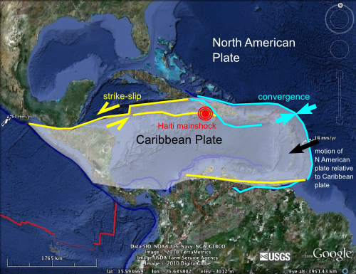
The
Caribbean is contained on its own separate little plate; a rather
diminutive part of the tectonic jigsaw that is the Earth’s crust. It is
surrounded on three sides by the much larger North and South American
plates, both of which are moving approximately westwards with respect to
the Caribbean plate at around 2-3 centimetres a year. On the eastern
edge of the plate, the boundary runs perpendicular to the direction of
relative plate motion, so there is compression and subduction (and
subduction volcanism, exemplified by the likes of Montserrat). However,
as the boundary curves around to form the northern boundary of the
Caribbean plate, where the Haitian earthquake occurred, it starts to run
parallel to the direction of relative plate motion, making strike-slip
faulting along E-W trending faults the most likely expression of
deformation in this region. This is exactly what the Haitian quake
appears to record.
Note also that deformation across the northern
plate boundary appears to be distributed – some motion is accommodated
on faults that are located a little bit away from the actual plate
boundary, further inside the plate interior. The Haitian quake appears
to have occurred on one of these faults: based on the position of its
epicentre the rupture is extremely close to the Enriquillo Fault, which
appears to be a major strike slip fault running across the southern end
of Haiti. This is the fault most likely to have ruptured...

(Tectonic map of the Northern Caribbean).
http://all-geo.org/highlyallochthonous/2010/01/tectonics-of-the-haitian-earthquake/
-------------------------------
Caribbean Plate
https://www.sciencedirect.com/topics/earth-and-planetary-sciences/caribbean-plate
-------------------------------
Chapter 10 - Geology and Hydrogeology of St. Croix, Virgin Islands
https://www.sciencedirect.com/science/article/pii/S0070457104800323
-------------------------------
Chapter 15 - Strike-Slip Fault Systems Along the Northern Caribbean Plate Boundary
2019
https://www.sciencedirect.com/science/article/pii/B9780128120644000153
-------------------------------
21 - The Barbados ridge: A mature accretionary wedge in front of the Lesser Antilles active margin
2012
https://www.sciencedirect.com/science/article/pii/B9780444530424000212
-------------------------------
On the Relationship Between Subduction Interface Roughness and Megathrust Earthquakes
2019
https://www.sciencedirect.com/science/article/pii/B9780124095489117646
-------------------------------
Motion of Caribbean Plate during last 7 million years and implications for earlier Cenozoic movements
December1982
https://agupubs.onlinelibrary.wiley.com/doi/10.1029/JB087iB13p10656
Abstract
The direction and rate of movement of the Caribbean plate with respect
to North America are determined from the slip vectors of shallow
earthquakes and from the configuration of downgoing seismic zones in the
Greater and Lesser Antilles. A calibration of the relative plate motion
for the northeastern Caribbean using data from other subduction zones
indicates an average rate of 3.7±0.5 cm/yr for the past 7 million years
(Ma). The direction of plate motion inferred from focal mechanisms (ENE)
is nearly the same as that deduced from the configuration of downgoing
seismic zones going around the major bend in the arc. With respect to
North America, the Caribbean plate is moving at an angular velocity of
0.36°/Ma about a center of rotation near 66°N, 132°W. Vector addition
using those data and that for the relative motion of North and South
America indicates that the Caribbean is moving at an angular velocity of
0.47°/Ma about a center of rotation near 60°N, 88°W with respect to
South America. The presence of intermediate‐depth earthquakes beneath
Puerto Rico and the Virgin Islands is ascribed to the curvature of the
plate boundary and a component of underthrusting that has been going on
for at least the past 7 Ma and is likely occurring today. The
alternative hypothesis that earthquakes beneath those areas are
occurring in materials that were subducted during the Eocene, the last
major episode of magmatism, is not tenable from thermal considerations.
The lack of recent magmatism in the eastern Greater Antilles is ascribed
to the relatively small component of underthrusting. The 2 cm/yr rate
of seafloor creation along the mid‐Cayman spreading center for the past
2.4 Ma does not appear to reflect the total Caribbean‐North American
plate motion while the 4 cm/yr spreading rate from 6.0 to 2.4 Ma does.
Between the mid‐Cayman spreading center and eastern Guatemala, the
northern boundary of the Caribbean plate is narrow and follows the
southern margin of the Cayman trough. Seismic activity between the
spreading center and eastern Hispaniola, however, occurs over a zone
about 250 km wide that extends from Cuba to Jamaica and across the
entire width of Hispaniola. Individual faults within this broad plate
boundary appear to have accommodated differing amounts of motion as a
function of geological time while the cumulative plate motion across the
zone remained nearly constant. The percentage of total plate motion
accommodated near southern Hispaniola and Jamaica is inferred to have
increased about 2.4 Ma ago. That change may have been caused by the
collision of parts of the Bahama bank and northern Hispaniola. This
explanation for the sudden decrease in seafloor creation along the
mid‐Cayman spreading center is less catastrophist than the hypothesis
that the entire Caribbean plate suddenly changed its velocity with
respect to surrounding plates. The Caribbean plate may be regarded as a
small buffer plate whose motion is now governed by the movement of the
larger North and South American plates which bound it on three sides.
The Caribbean plate is either at rest or moving eastward at a rate of no
more than 1 cm/yr in the hot spot reference frame. Since the relative
motion of the larger plates surrounding the Caribbean has been nearly
constant for the last 38 Ma (anomaly 13 time) and since the forces on
the Caribbean plate do not appear to have changed greatly during that
interval, we extrapolate the motion of the last 7 Ma back to 38 Ma. A
reconstruction for the late Eocene places the Caribbean plate about 1400
km west of its present position. The faster rate of plate motion we
calculate makes it more likely that the lithosphere beneath the basins
of the Caribbean originated in the Pacific. It also has implications for
the seismic potential of the region, paleocirculation in the Atlantic
Ocean and origin of sediments in the area. Our late Eocene
reconstruction aligns the eastern continental margin of Yucatan with
that along the southeast side of the Nicaragua rise. This 2500‐km‐long
feature may have acted as an arc‐arc transform fault from the late
Mesozoic to the late Eocene. Arc‐related rocks of those ages in the
Greater Antilles and northern Lesser Antilles define a northwesterly
trending subduction zone along the northeastern edge of the former East
Pacific‐Caribbean plate. At least three fragments of anomalous seafloor
have been sutured onto Hispaniola in the past 50 Ma.
-------------------------------
Tectonic Plates Formed Caribbean Island ‘Arc’ 50 Million Years Ago, Study Says
08/21/2012
https://www.huffpost.com/entry/tectonic-plates-caribbean-islands-study_n_1823487
-------------------------------
Tectonic Shoving Match Formed Caribbean Island Arc
https://www.livescience.com/22566-caribbean-arc-tectonics.html
-------------------------------
The Caribbean Plate Evolution: Trying to Resolve a Very Complicated Tectonic Puzzle
2011
https://www.intechopen.com/books/new-frontiers-in-tectonic-research-general-problems-sedimentary-basins-and-island-arcs/the-caribbean-plate-evolution-trying-to-resolve-a-very-complicated-tectonic-puzzle
-------------------------------
Plate boundary segmentation in the northeastern Caribbean from geodetic measurements and Neogene geological observations
January 2016
https://www.sciencedirect.com/science/article/pii/S1631071315001728
Abstract
The
Caribbean–North America plate boundary in the northeastern Caribbean
shows a remarkable example of along-strike transition from plate
boundary–normal subduction in the Lesser Antilles, oblique subduction
with no strain partitioning in Puerto Rico, and oblique
subduction/collision with strain partitioning further west in
Hispaniola. We show that this segmentation is well marked in the
interseismic strain, as measured using space geodetic data, and in the
Neogene deformation regime, as derived from geological observations.
Hence, interseismic segmentation, which reproduces the geological
segmentation persistent over a long time interval, is inherited from the
geological history and long-term properties of the plate boundary. This
result is relevant to the assessment of seismic hazard at convergent
plate boundaries, where geodetic measurements often show interseismic
segmentation between fully–and partially–coupled plate interface
regions.
-------------------------------
Unusual Behavior of Tectonic Plates in Central America Is Warned by Experts
https://thecostaricanews.com/unusual-behavior-of-tectonic-plates-in-central-america-is-warned-by-experts/
-------------------------------
What are the Tectonic Plates in Mexico?
https://www.lifepersona.com/what-are-the-tectonic-plates-in-mexico
The
Tectonic plates in Mexico Are very peculiar because their way of
converging is different from that of other regions of the planet.
The
surface of the earth did not always have the appearance we see today.
The continental masses float on a magma or molten rock, and are divided
in plates that rub and collide with each other, which gives origin to
the mountains, marine abysses and earthquakes.
In 1620, Sir
Francis Bacon, an English philosopher very devoted to political affairs,
who devoted the last years of his life to science, noted how the coasts
of the American and European continents on the map fit perfectly.
Based
on this a hypothesis was elaborated in 1912, by German Alfred Wegener
-supported by the finding of similar fossils in places far away from the
planet- that the continents were moving in a viscous mantle.
These theories lacked credibility until the 1960s, when the tectonic plates .
It
was determined that the movement of the plates has been developing for
millions of years and that there existed a supercontinent called Pangea
that grouped all the present continental surfaces, separated thanks to
the reconfiguration and constant displacement of the Lithosphere .
In
the zones of convergence of plates several phenomena can happen. If one
plate moves on another, it is said that there is a subduction and as a
result a rise, producing mountain chains and volcanoes. If there is a
collision, mountains occur and there is high seismicity or probability
of earthquakes occurring.
Some countries like Mexico own part of
their territory in several zones or tectonic plates. As a consequence,
they are areas of high seismic activity and volcanism.
The peculiar tectonic plates of Mexico
The countries where tectonic plates converge have similar characteristics. However Mexico is different.
For
example, when the plates converge, earthquakes have their origin at a
depth of 600 km and yet in Mexico, an earthquake has rarely been
detected below 100 km.
In most of the subduction zones, volcanic
arcs parallel to the trench left by the plates originate. In Mexico this
arch moves away from the trench at an angle of about 15 °.
In
most subduction zones, large earthquakes occur with a frequency of a few
hundred years. In Mexico it occurs only on the coast, and in addition
has been detected a modality called"silent earthquake", undetectable and
with a duration of up to one month.
Most of Mexico is located at
the bottom of the large American plate. In the south part it converges
with the plate of the Caribbean.
This plate covers both the
Caribbean Sea and most of the Antilles, including much of Cuba, a part
of South America and almost all of Central America. From Mexico, the
Caribbean plate contains south of Chiapas.
The California
peninsula is located on the Pacific plate, which moves northwest and
below the American plate. In the zone of encounter of these two plates
is located the fault of San Andrés, that is famous for its high seismic
activity.
The Rivera Plate is a small plate located between
Puerto Vallarta and the south of the California peninsula. Its movement
is towards the southeast, bordering the Pacific plate and submerging
under the North American plate.
The Orozco and Cocos plates are
oceanic crusts located in the southern part of Mexico. The collision
between the two was the cause of the great earthquake of 1985 in Mexico
City as well as the most recent earthquake of 2012.
Tectonic
plates may have three types of edges between them. They are said to be
divergent if the plates move away from each other, leaving a space where
there may be volcanic eruptions and earthquakes.
On the other hand, they are convergent when the plates are rather well, and one of the following cases may occur:
1-
Subduction limit : One plate is folded down the other, into the earth.
This can occur on both the continental and oceanic sides, creating a
fringe or crack, as well as a mountainous and volcanic chain.
2- Collision Limit : Two continental plates approach each other, creating great mountain ranges like the Himalayas.
3-
Friction limit : Where the plates are separated by tranches of faults
that transform, giving rise to straight and narrow valleys in the ocean
floor.
Extra concepts on tectonic plates
Current theory suggests that tectonic plates have a thickness of between 5 and 65 kilometers.
The
Earth crust Is divided into approximately twelve plates, which drift in
different directions at different speeds, a few centimeters a year, as a
result of Convection currents Thermal insulation of the earth's mantle.
Extra concepts about f Allas
When the tectonic plate
forces exceed the capacity of shallow rocks (located 200km deep), they
fracture resulting in a discontinuity.
The fault zone is called the rupture zone, and it has a parallel slip of the rocks.
The
active faults are those that continue to slide today, while the
inactive ones have more than 10 thousand years without presenting
movement. However it is not ruled out that an inactive fault could
eventually be activated.
If the movement of the fault is gradual
and the tension is slowly released, the fault is said to be asismic,
whereas if the movement is abrupt, the fault is said to be seismic. A
large earthquake is caused by d jumps between 8 to 10 meters between the
edges of a fault.
-------------------------------
Tectonic evolution of the Gulf of Mexico, Caribbean and northern South America in the mantle reference frame: an update
2009
https://www.semanticscholar.org/paper/Tectonic-evolution-of-the-Gulf-of-Mexico%2C-Caribbean-Pindell-Kennan/a3100323b96efc10580c49925f49d247e9a62b8e
Abstract
Abstract We present an updated synthesis of the widely accepted
‘single-arc Pacific-origin’ and ‘Yucatán-rotation’ models for Caribbean
and Gulf of Mexico evolution, respectively. Fourteen palaeogeographic
maps through time integrate new concepts and alterations to earlier
models. Pre-Aptian maps are presented in a North American reference
frame. Aptian and younger maps are presented in an Indo-Atlantic hot
spot reference frame which demonstrates the surprising simplicity of
Caribbean–American interaction. We use the Müller et al. (Geology 21:
275–278, 1993) reference frame because the motions of the Americas are
smoothest in this reference frame, and because it does not differ
significantly, at least since c. 90 Ma, from more recent ‘moving hot
spot’ reference frames. The Caribbean oceanic lithosphere has moved
little relative to the hot spots in the Cenozoic, but moved north at c.
50 km/Ma during the Cretaceous, while the American plates have drifted
west much further and faster and thus are responsible for most
Caribbean–American relative motion history. New or revised features of
this model, generally driven by new data sets, include: (1) refined
reconstruction of western Pangaea; (2) refined rotational motions of the
Yucatán Block during the evolution of the Gulf of Mexico; (3) an origin
for the Caribbean Arc that invokes Aptian conversion to a SW-dipping
subduction zone of a trans-American plate boundary from Chortís to
Ecuador that was part sinistral transform (northern Caribbean) and part
pre-existing arc (eastern, southern Caribbean); (4) acknowledgement that
the Caribbean basalt plateau may pertain to the palaeo-Galapagos hot
spot, the occurrence of which was partly controlled by a Proto-Caribbean
slab gap beneath the Caribbean Plate; (5) Campanian initiation of
subduction at the Panama–Costa Rica Arc, although a sinistral transform
boundary probably pre-dated subduction initiation here; (6) inception of
a north-vergent crustal inversion zone along northern South America to
account for Cenozoic convergence between the Americas ahead of the
Caribbean Plate; (7) a fan-like, asymmetric rift opening model for the
Grenada Basin, where the Margarita and Tobago footwall crustal slivers
were exhumed from beneath the southeast Aves Ridge hanging wall; (8) an
origin for the Early Cretaceous HP/LT metamorphism in the El Tambor
units along the Motagua Fault Zone that relates to subduction of
Farallon crust along western Mexico (and then translated along the
trans-American plate boundary prior to onset of SW-dipping subduction
beneath the Caribbean Arc) rather than to collision of Chortis with
Southern Mexico; (9) Middle Miocene tectonic escape of Panamanian
crustal slivers, followed by Late Miocene and Recent eastward movement
of the ‘Panama Block’ that is faster than that of the Caribbean Plate,
allowed by the inception of east–west trans-Costa Rica shear zones. The
updated model integrates new concepts and global plate motion models in
an internally consistent way, and can be used to test and guide more
local research across the Gulf of Mexico, the Caribbean and northern
South America. Using examples from the regional evolution, the processes
of slab break off and flat slab subduction are assessed in relation to
plate interactions in the hot spot reference frame.
-------------------------------
Gulf of Mexico, Central America, and the Caribbean
https://www.sciencedirect.com/science/article/pii/B9780081029084001181
Abstract
The
geology of the Gulf of Mexico-Caribbean-Central America region and its
five major ocean basins was shaped by late Paleozoic formation of the
Pangean supercontinent that was followed by breakup of the
supercontinent Pangea during the Triassic and Jurassic period. The Gulf
of Mexico (GOM) basin opened in two phases in the period of late
Triassic to earliest Cretaceous. Northeast-trending rift basins formed
in response to the northwest-southeast extension in areas located south
of the Appalachian fold-thrust belt. Late Jurassic (Callovian) salt
deposition occurred in a largely unfaulted and extensive sag basin
setting above these late Triassic-late early Jurassic Phase 1 rifts.
Late Jurassic, Phase 2 rifting initiated by counterclockwise rotation of
the Yucatan block. Counterclockwise rotation of the Yucatan block led
to oceanic spreading that separated the single GOM salt basin into two
parts: the Louann salt basin now in the US GOM and the Campeche salt
basin now in the Mexico GOM. Previous studies have compiled observations
that are supportive of the Pacific model of the Caribbean rather than
the alternative in situ model for the Caribbean plate. The present-day
Caribbean plate originated as a Pacific-derived, intra-oceanic arc
system, the Great Arc of the Caribbean that enclosed the late Cretaceous
Caribbean large igneous province. During the Cenozoic, the Great Arc
moved northeastward consuming the ocean basin formed by Pangea's breakup
until it collided with the Bahamas platform, turned more in an
eastwardly direction, and is today manifested as the Lesser Antilles arc
system.
-------------------------------
This Recent Earthquake Was So Intense, It Has Cracked a Tectonic Plate in Two
OCTOBER 25, 2018
https://www.sciencealert.com/mexico-tehuantepec-chiapas-magnitude-8-2-intraplate-earthquake-ruptured-tectonic-plate-all-the-way-through
The
beast of an earthquake that rattled Mexico in September of last year
has turned out to be even more unusual than we knew. Not only did it hit
magnitude 8.2 and produce strange lights in the sky, seismologists have
now revealed it also cracked a tectonic plate all the way through.
"If
you think of it as a huge slab of glass, this rupture made a big,
gaping crack," seismologist Diego Melgar of the University of Oregon
told National Geographic.
"All indications are that it has broken through the entire width of the thing."
The
Tehuantepec, or Puebla-Morelos earthquake took place in the Pacific
Ocean off the west coast of Mexico. All along that coast is a tectonic
border, between the Cocos Plate in the ocean, and the North American,
Caribbean, and Panama Plates that make up the Central American land
mass.
As such, the region is no stranger to quakes and tremors as the edge of the Cocos Plate moves beneath the continental plates.
But
the Tehuantepec quake on September 7, and the slightly smaller
magnitude 7.1 quake that followed on September 19, were both a rare type
of "bending" earthquake.
These start off normally, with the tectonic plates colliding, and one starting to slip down underneath the other.
"But
then, just as [the Cocos Plate] begins to jut underneath the Mexican
mainland, the plate - which is made of dense, heavy rocks - reverses
course. It bends upward, sliding itself horizontally beneath the plate
Mexico sits on top of. This setup continues for about 125 miles [200 km]
or so," Melgar and Universidad Nacional Autónoma de México seismologist
Xyoli Pérez-Campos explained for The Conversation last month.
"Then,
underneath Puebla state - just south of Mexico City - at a depth of
about 30 miles [48km] below ground, the subducted plate abruptly changes
direction once more. It dives almost vertically downward, plunging
itself deep into the Earth's mantle."
This buckles and bends the
tectonic plate, a bit like a piece of wood, or a strip of thick rubber.
It will stretch up until a certain point - and then it ruptures,
resulting in a violent earthquake.
These are called intraplate,
or intraslab, earthquakes, because they occur at a considerable distance
from the tectonic plate boundary.
Again, though, the Tehuantepec
quake was different. When you bend an object, the outside stretches,
while the inside is compressed. So it stands to reason that an
intraplate earthquake rupture would only affect the top part of the
tectonic plate.
But Melgar and his team found that the Cocos
Plate ruptured even through the bottom part of the tectonic plate, to
the part that should have been compressing.
This was at a depth of about 80 kilometres (50 miles), so the very bottom edge of the tectonic plate.
And
that's another problem. At the bottom of the tectonic plate,
temperatures reach 1,100 degrees Celsius (2,012 Fahrenheit). This should
make the rock too squishy and elastic to rupture - yet according to the
team's data, rupture it did.
Why did all this happen? The team's
paper puts forth two explanations. The first is that the gravitational
force pulling the tectonic plate downwards is pulling it with enough
force to counteract the rock's squashed and squishy state.
The
second is that seawater could be playing a role too - seeping down into
the fault, bringing cooler temperatures and reactions with the minerals
in the rock to increase brittleness.
"Deep slip down to the
1,100 °C geotherm requires a substantial deviation from the reference
thermal model, suggesting very deep injection of fluids from above and
cooling of the fault," the researchers wrote.
"This indicates
fluid penetration much deeper than any of the modelling or observations
have suggested before. Alternatively, a water-independent process that
increases the range of possible temperatures for earthquake slip up to
850 °C could induce shear heating instabilities on localised shear
zones."
The Tehuantepec quake's epicenter was on the land side of
the fault, which is damaging enough - it destroyed buildings, killed at
least 98 people, and injured many more.
It also generated a
tsunami, with waves reaching 1.75 metres (5.74 feet) above tide level.
Had the quake's epicentre been on the ocean side, that could have been
even more devastating, like the devastating 1933 intraplate earthquake
off the Japan Trench, which produced 20 metre (65.6-foot) waves.
Knowing what caused the Cocos Plate to rupture could help us plan for and alleviate the human cost of such events in the future.
The team's research has been published in the journal Nature Geoscience.
-------------------------------
Tectonic plates moving again: will South America split away from Central America?
March 7, 2013
https://theextinctionprotocol.wordpress.com/2013/03/07/tectonic-plates-moving-again-will-south-america-split-away-from-central-america/
-------------------------------
Plate Tectonics Becoming Clearer With Computers

Mechanisms for the recent Virginia and Oklahoma earthquakes that occurred within the North American plate, and the 2010 Haiti Earthquake that occurred on the plate boundary between the North American and Caribbean plates. Crustal stresses predicted by our models, which account for both shallow and deeper density sources, are consistent with the directions of crustal compression experienced in these earthquakes. These stress solutions provide clues about the sources of deformation within the plate boundary zones, and about the ultimate causes of crustal strain within plates.
https://www.livescience.com/18529-plate-tectonics-computer-models.html
-------------------------------
Iceland earthquakes, 18000 in a week! Significance?
Mar 6, 2021
https://www.physicsforums.com/threads/iceland-earthquakes-18000-in-a-week-significance.1000553/
-------------------------------
Crustal seismic velocity responds to a magmatic intrusion and seasonal loading in Iceland’s Northern Volcanic Zone
Nov 2019
https://advances.sciencemag.org/content/5/11/eaax6642
Abstract
Seismic noise interferometry is an exciting technique for studying
volcanoes, providing a continuous measurement of seismic velocity
changes (dv/v), which are sensitive to magmatic
processes that affect the surrounding crust. However, understanding the
exact mechanisms causing changes in dv/v is often difficult. We present dv/v
measurements over 10 years in central Iceland, measured using
single-station cross-component correlation functions from 51 instruments
across a range of frequency bands. We observe a linear correlation
between changes in dv/v and volumetric strain at
stations in regions of both compression and dilatation associated with
the 2014 Bárðarbunga-Holuhraun dike intrusion. Furthermore, a clear
seasonal cycle in dv/v is modeled as resulting from
elastic and poroelastic responses to changing snow thickness,
atmospheric pressure, and groundwater level. This study comprehensively
explains variations in dv/v arising from diverse crustal stresses and highlights the importance of deformation modeling when interpreting dv/v, with implications for volcano and environmental monitoring worldwide.
-------------------------------
Long-Lost Tectonic Plate Discovered Hundreds of Miles Below Canada
10/21/20
https://www.newsweek.com/lost-tectonic-plate-canada-geology-1540998
-------------------------------
Newly Discovered Hot Magma Plume Beneath Yellowstone Volcano Stretches To Mexico
2018
https://www.techtimes.com/articles/223457/20180322/newly-discovered-hot-magma-plume-beneath-yellowstone-volcano-stretches-to-mexico.htm
New
evidence on Yellowstone's volcanic activity might shed light on the
long-debated theory on the presence of magma plume beneath the national
park.
The Yellowstone caldera is a complex system of
rock formations that sprung after a series of volcanic eruptions some
630,000 million years ago. This is the widely accepted theory, although
there are some scientists who argue that the national park sits right on
top of a "hot spot."
Results of the investigation
conducted by Peter Nelson and Stephen Grand from the University of
Texas' Jackson School of Geosciences supports the latter theory
suggesting a massive magma plume beneath the park's surface. This plume,
which is the technical word for a magma foundation, appears to extend
as far as Mexico.
How Plumes Are Formed
In
a geographic sense, a plume is an abnormality that exists when the
earth's core rises through the mantle forming what it appears to be a
foundation of hot magma.
The study, which was published
in Nature Geoscience, reported that the probability of a magma plume
underneath Yellowstone could explain the heat that influences ground
activities such as the Boiling River. This latest claim debunks earlier
explanations that the heat source is a by-product of lithospheric
movements.
Nelson and Grand's team gathered seismic
data using EarthScope's USArray, which showed a "long, thin, sloping
zone" that measured about 72 kilometers long and 55 kilometers wide.
Because seismic patterns travel slower in this region of the mantle, it
is understandable that it can be up to 800 degrees Celsius higher than
its surrounding areas.
The emerging image revealed a 350-kilometer cylinder formation that runs all the way to the California-Mexico border.
--------------------------------
Yellowstone's Steamboat Geyser Is Incredibly Active Right Now, and We Don't Know Why
June 26, 2019
https://www.livescience.com/65802-yellowstone-geyser-record.html
-------------------------------
Yellowstone Scientists Have Just Discovered A Dome Shaped Uplift Inside The Volcano System
Oct 28, 2020
https://www.youtube.com/watch?v=tOQeExNd4ws
-------------------------------
A New Giant Hole in the Planet Earth!
Dec 4, 2019
{West Coast of America, North American Plate, Pacific Plate, Juan de Fuca Plate & the Demise of the Farallon Plate}.
https://www.youtube.com/watch?v=YDfLYQydl8M
-------------------------------
A tectonic plate is dying under Oregon. Here’s why that matters.
July 29, 2019
A peek into the curious geology of the Pacific Northwest helps tease
apart what may happen when the last bits of an oceanic plate get
swallowed up.
https://www.nationalgeographic.com/science/2019/07/tectonic-plate-dying-oregon-why-matters/
-------------------------------
California supervolcano may be as dangerous as Yellowstone's
2018
https://www.sfgate.com/science/article/long-valley-caldera-supervolcano-California-13265467.php
-------------------------------
NASA Study Connects Southern California, Mexico Faults
2018
https://www.nasa.gov/feature/jpl/nasa-study-connects-southern-california-mexico-faults
-------------------------------
This Quiet Fault in Southern California Hadn't Moved in 500 Years. Now It's Slipping.
Oct 17, 2019
Earthquake Pre-cursors? 'Slow slip Monitoring' {Video}
https://www.livescience.com/earthquakes-cause-fault-to-slip-in-california.html
-------------------------------
Mexico Earthquake Zone Linked to California Faults
https://news.nationalgeographic.com/news/2010/04/100405-mexico-california-baja-earthquake-aftershocks/
-------------------------------
Volcanoes of Mexico (42 volcanoes)
https://www.volcanodiscovery.com/mexico.html
Mexico's
volcanoes are part of the Pacific Ring of Fire and formed on the North
American continental tectonic plate under which the oceanic Pacific and
(in the south) Cocos plates are being subducted.
The most active
volcanoes of the country are Popocatepetl, Colima and El Chichon, which
had a major eruption in 1982 that cooled the world's climate in the
following year.
All active volcanoes of Mexico are listed.
-------------------------------
There are 48 active volcanoes in Mexico
2018
https://www.vallartadaily.com/volcanoes-in-mexico/
-------------------------------
List of volcanoes in Mexico
https://en.wikipedia.org/wiki/List_of_volcanoes_in_Mexico
-------------------------------
Mexico's deadliest volcano
2018
https://theweek.com/articles/805797/mexicos-deadliest-volcano
On
the clear-sky morning of December 21st, 1994, Claus Siebe was standing
at the foot of Popocatépetl, watching as elephantine plumes of black
smoke and heaps of pyroclastic flow spewed out of Mexico's largest
active volcano. Siebe stood silently next to a group of mountaineers,
all of whom had their heads cocked upward. He'd never witnessed an
eruption on this scale before; he was floored. Recalling that day now,
nearly 24 years later, Siebe describes a scene of awe and confusion.
"Everybody was watching," Siebe says. "Nobody panicked. We were all just
kind of surprised that this was happening."
-------------------------------
1943-1952
The eruption of Parícutin
https://mashable.com/2017/06/24/eruption-of-paricutin/
-------------------------------
The Surprising Threat from Mexico's Awakened Volcano
2012
https://www.livescience.com/31391-popocatepetl-mudflow-threat.html
-------------------------------
Mexico raises alert level for Popocatepetl volcano as activity intensifies
March 28, 2019
Mexican volcano erupts multiple times in a day
The Popocatépetl volcano in central Mexico erupted three times on Nov. 24.
https://www.reuters.com/article/us-mexico-volcano/mexico-raises-alert-level-for-popocatepetl-volcano-as-activity-intensifies-idUSKCN1R9256
-------------------------------
The effects of volcanoes on health: preparedness in Mexico.
1996
https://www.ncbi.nlm.nih.gov/pubmed/9170236
-------------------------------
Colima Volcano blasts ash, lava in western Mexico
2015
http://www.msnbc.com/msnbc/colima-volcano-blasts-ash-lava-western-mexico
MEXICO
CITY – A volcano in western Mexico has erupted, spewing ash more than 4
miles (7 kilometers) into the air and sending lava down its flanks.
The
activity at the Colima Volcano began Thursday and continued Friday
morning. The volcano is also known as the Volcano of Fire.
Luis Felipe Puente is director of Mexico’s civil protection agency. He tweeted Friday that preventive protocols were activated.
A
statement from Colima state’s civil protection agency on Thursday said
the initial eruption occurred just after 11 a.m. Ash was falling to the
southwest of the crater. People were advised to recognize a 3-mile
(5-kilometer) perimeter around the peak.
A state helicopter was making a reconnaissance flight Friday morning.
-------------------------------
Colima eruption is a reminder that Mexico is a land of volcanoes
2016
http://theconversation.com/colima-eruption-is-a-reminder-that-mexico-is-a-land-of-volcanoes-66478
-------------------------------
The possible influence of volcanic emissions on atmospheric aerosols in the city of Colima, Mexico.
2004
http://europepmc.org/abstract/med/14568726
-------------------------------
Mexico’s Popocatepetl Volcano Erupts, Residents Prepare for More Volcanic Activity
March 29, 2019
https://fox28spokane.com/mexicos-popocatepetl-volcano-erupts-residents-prepare-for-more-volcanic-activity/
Areas
in Central Mexico are preparing for the worst after Mexico’s
Popocatepetl volcano unleashed a powerful explosion Thursday evening.
Mexican
authorities had just raised the alert level for the volcano, indicating
an increase in the intensity of activity, when the volcano exploded.
Witnesses
in the area say they saw a large flash of light followed by
incandescent material spilling out from the crater and down the
mountainside. Reports show the explosion sent a massive column of gas
and ash 8,200 feet above the volcano’s crater.
Mexico’s
National Center for Disaster Prevention have warned residents to stay
away from the volcano. Scientists monitoring Popocatepetl have observed
more than 200 discharges from the volcano in the past 24 hours.
-------------------------------
New satellite-based study of Latin America volcanoes could help researchers better predict eruptions
April 04, 2019
https://reliefweb.int/report/world/new-satellite-based-study-latin-america-volcanoes-could-help-researchers-better-predict
-------------------------------
Mud volcano
https://en.wikipedia.org/wiki/Mud_volcano#Yellowstone's_%22Mud_Volcano%22
Mud volcano in the Gulf of Mexico sea bottom
Two
seismic-reflection scans of a fault zone in the Gulf of Mexico. A.
Chirp seismic-reflection B. Water gun seismic-reflection. Chirp
seismic-reflection show a likely mud volcano adjacent to the fault zone
where near-surface seismic-reflection amplitudes are high and the
seafloor is disrupted. Water gun data illustrate that the high-amplitude
reflections extend downward in two zones, one that projects steeply
(i.e., the master fault with likely gas/fluid) and another that projects
laterally along apparent stratigraphy (i.e., a potential gas/fluid
charged stratal unit). The fault zone has high backscatter at the sea
floor, and is an area of likely upward migrating gases, fluids, and
mobilized sediment, with contributions from the two subsurface
high-amplitude zones.
-------------------------------
New evidence suggests volcanoes caused biggest mass extinction ever
April 15, 2019
Mercury found in ancient rock around the world supports theory that eruptions caused 'Great Dying' 252 million years ago.
The
mass extinction occurred at what scientists call the Permian-Triassic
Boundary. The mass extinction killed off much of the terrestrial and
marine life before the rise of dinosaurs. Some were prehistoric monsters
in their own right, such as the ferocious gorgonopsids that looked like
a cross between a sabre-toothed tiger and a Komodo dragon.
The
eruptions occurred in a volcanic system called the Siberian Traps in
what is now central Russia. Many of the eruptions occurred not in
cone-shaped volcanoes but through gaping fissures in the ground. The
eruptions were frequent and long-lasting and their fury spanned a period
of hundreds of thousands of years.
https://www.sciencedaily.com/releases/2019/04/190415122249.htm
-------------------------------
Dinosaur asteroid hit 'worst possible place'
2017
https://www.bbc.com/news/science-environment-39922998
The researchers recovered rocks from under the Gulf of Mexico that were hit by an asteroid 66 million years ago.
The nature of this material records the details of the event.
It is becoming clear that the 15km-wide asteroid could not have hit a worse place on Earth.
The shallow sea covering the target site meant colossal volumes of
sulphur (from the mineral gypsum) were injected into the atmosphere,
extending the "global winter" period that followed the immediate
firestorm.
Had the asteroid struck a different location, the outcome might have been very different.
"This is where we get to the great irony of the story – because in the
end it wasn’t the size of the asteroid, the scale of blast, or even its
global reach that made dinosaurs extinct – it was where the impact
happened," said Ben Garrod, who presents The Day The Dinosaurs Died with
Alice Roberts.
"Had the asteroid struck a few moments earlier or later, rather than
hitting shallow coastal waters it might have hit deep ocean.
"An impact in the nearby Atlantic or Pacific oceans would have meant
much less vaporised rock – including the deadly gypsum. The cloud would
have been less dense and sunlight could still have reached the planet’s
surface, meaning what happened next might have been avoided.
"In this cold, dark world food ran out of the oceans within a week and
shortly after on land. With nothing to eat anywhere on the planet, the
mighty dinosaurs stood little chance of survival."
Ben Garrod spent time on the drill rig that was stationed 30km off
Mexico's Yucatan Peninsula in April/May last year, to better understand
the aims of the project; Alice Roberts visited widely separated fossil
beds in the Americas, to get a sense of how life was upended by the
impact.
Rock cores from up to 1,300m beneath the Gulf were recovered.
The lowest sections of this material come from a feature within the crater called the peak ring.
This is made from rock that has been heavily fractured and altered by immense pressures.
By analysing its properties, the drill project team - led by Profs Jo
Morgan and Sean Gulick - hope to reconstruct how the impact proceeded
and the environmental changes it brought about.
They know now the energy that went into making the crater when the
asteroid struck - equivalent to 10 billion Hiroshima A-bombs. And they
also understand how the depression assumed the structure we observe
today.
The team is also gaining insights into the return of life to the impact site in the years after the event.
One of the many fascinating sequences in the BBC Two programme sees
Alice Roberts visit a quarry in New Jersey, US, where 25,000 fossil
fragments have been recovered - evidence of a mass die-off of creatures
that may have been among the casualties on the day of the impact itself.
"All these fossils occur in a layer no more than 10cm thick," palaeontologist Ken Lacovara tells Alice.
"They died suddenly and were buried quickly. It tells us this is a
moment in geological time. That's days, weeks, maybe months. But this is
not thousands of years; it's not hundreds of thousands of years. This
is essentially an instantaneous event."
-------------------------------
Asteroid strike made 'instant Himalayas'
2016
https://www.bbc.com/news/science-environment-38019604
Scientists say they can now describe in detail how the asteroid that wiped out the dinosaurs produced its huge crater.
The reconstruction of the event 66 million years ago was made possible
by drilling into the remnant bowl and analysing its rocks.
These show how the space impactor made the hard surface of the planet slosh back and forth like a fluid.
At one stage, a mountain higher than Everest was thrown up before collapsing back into a smaller range of peaks.
"And this all happens on the scale of minutes, which is quite amazing,"
Prof Joanna Morgan from Imperial College London, UK, told BBC News.
The researchers report their account in this week's edition of Science Magazine.
Their study confirms a very dynamic, very energetic model for crater
formation, and will go a long way to explaining the resulting
cataclysmic environmental changes.
The debris thrown into the atmosphere likely saw the skies darken and
the global climate cool for months, perhaps even years, driving many
creatures into extinction, not just the dinosaurs.
The team spent April to May this year drilling a core through the
so-called Chicxulub Crater, now buried under ocean sediments off
Mexico's Yucatan Peninsula...
The analysis of the core materials now fits an astonishing narrative.
This describes the roughly 15km-wide stony asteroid instantly punching a
cavity in the Earth's surface some 30km deep and 80-100km across.
Unstable, and under the pull of gravity, the sides of this depression promptly started to collapse inwards.
At the same time, the centre of the bowl rebounded, briefly lifting rock
higher than the Himalayas, before also falling down to cover the
inward-rushing sides of the initial hole.
"If this deep-rebound model is correct (it's called the dynamic collapse
model), then our peak ring rocks should be the rocks that have
travelled farthest in the impact - first, outwards by kilometres, then
up in the air by over 10km, and back down and outwards by another, say,
10km. So their total travel path is something like 30km, and they do
that in under 10 minutes," Prof Gulick told the BBC's Science in Action
programme.
Imagine a sugar cube dropped into a cup of tea. The drink's liquid first
gets out of the way of the cube, moves back in and up, before finally
slopping down.
When the asteroid struck the Earth, the rocks it hit also behaved like a fluid.
"These rocks must have lost their strength and cohesion, and very
dramatically had their friction reduced," said Prof Morgan. "So, yes,
temporarily, they behave like a fluid. It's the only way you can make a
crater like this."
-------------------------------
Asteroid that killed the dinosaurs caused a mile-high tsunami around the Earth
2019
The researchers noted that the impact tsunami in the Yucatán Peninsula
was 2,600 times more energetic than the Indian Ocean tsunami in December
2004, one of the largest tsunamis recorded in modern history.
https://www.foxnews.com/science/asteroid-that-killed-the-dinosaurs-caused-a-mile-high-tsunami-around-the-earth
-------------------------------
Animals in North Dakota Died from Chicxulub Asteroid in Mexico
April 2019
Fossils reveal the quick death of plants and animals from a massive
surge of water after the impact 66 million years ago, which is thought
to have spelled the demise of dinosaurs.
https://www.the-scientist.com/news-opinion/animals-in-north-dakota-died-from-chicxulub-asteroid-in-mexico-65684
-------------------------------
The buried secrets of the deadliest location on Earth
2018
Chicxulub Puerto, Mexico, is the centre of the impact crater that
scientists believe was made when the asteroid that wiped out the
dinosaurs smashed into the Earth’s surface.
http://www.bbc.com/travel/story/20181111-the-buried-secrets-of-the-deadliest-location-on-earth
-------------------------------
Chicxulub crater
The Chicxulub crater is an impact crater buried underneath the Yucatán Peninsula in Mexico.
Its center is located near the town of Chicxulub, after which the crater
is named. It was formed by a large asteroid or comet about 11 to 81
kilometres (6.8 to 50.3 miles) in diameter, the Chicxulub impactor,
striking the Earth
https://en.wikipedia.org/wiki/Chicxulub_crater
-------------------------------
This Is Why The Earth Could Explode Soon
Feb 2019
https://www.youtube.com/watch?v=VP4e0Uh6lAg
-------------------------------
Trillions Of Tonnes Of Water Is Being Swallowed Into The Earth's Interior
November 24th, 2018
http://www.ladbible.com/news/interesting-trillions-of-tonnes-of-water-is-being-swallowed-into-earths-interior-20181124
-------------------------------
Earth is Eating Its Oceans Way Faster Than Originally Thought, Study Finds
November 19 2018
https://weather.com/news/news/2018-11-19-earth-eating-oceans-mariana-trench
Three
times more ocean water than originally thought is being swallowed by
the Earth as the planet's tectonic plates sink below one another, a new
study discovered.
Published in the journal Nature, a
team of researchers took an estimate of how much water is being sucked
into the Earth's interior through subduction zones — where two
continental plates meet and one is being drawn downward.
Researchers
used data recorded by seismographs along the Mariana Trench — a
subduction zone where the Pacific Plate is subducted beneath the
Philippine Plate — to analyze a year's worth of measurements that
enabled them to draw a better picture of just how much water the rocks
inside the plates could hold. The determination was made by recording
the speed at which seismic waves travel through the rocks.
Near the Mariana Trench, at least 4.3 times more ocean water is subducted than previously thought.
This
discovery bodes large in understanding the Earth's deep water cycle,
said Columbia University's Donna Shillington. A marine geology and
geophysics researcher, Shillington said the water beneath the Earth's
surface can aid in the development of magma and could lubricate faults,
making earthquakes more likely.
Using velocity
measurements stretching down to 18 miles below the surface in a
combination of known temperatures and pressures, researchers were able
to calculate that subduction zones swallow 3 billion teragrams of water
into the crust every million years. A teragram is one trillion grams.
Unlike
the old adage "what goes up must come down," the opposite applies here.
Most of the water being subducted into the Earth is believed to be
emitted back into the atmosphere as water vapor in volcanic eruptions,
according to a Washington University release.
The
amount of ocean water ingested by the Earth and the amount emitted isn't
equal. In fact, the amount going in wildly exceeds the amount coming
out.
There's no missing water in the oceans, Cai said,
so there must be something about the way water moves through the Earth's
interior that scientists don't understand.
"Many more studies need to be focused on this aspect," said Cai.
-------------------------------
Iron 'jet stream' detected in Earth's outer core
December 2016
https://www.bbc.com/news/science-environment-38372342
Scientists say they have identified a remarkable new feature in Earth’s molten outer core.
They
describe it as a kind of "jet stream" - a fast-flowing river of liquid
iron that is surging westwards under Alaska and Siberia.
The moving mass of metal has been inferred from measurements made by Europe’s Swarm satellites.
This trio of spacecraft are currently mapping Earth's magnetic field to try to understand its fundamental workings.
The
scientists say the jet is the best explanation for the patches of
concentrated field strength that the satellites observe in the northern
hemisphere.
"This jet of liquid iron is moving at about fifty
kilometres per year," explained Dr Chris Finlay from the National Space
Institute at the Technical University of Denmark (DTU Space).
“That
might not sound like a lot to you on Earth's surface, but you have to
remember this a very dense liquid metal and it takes a huge amount of
energy to move this thing around and that's probably the fastest motion
we have anywhere within the solid Earth,” he told BBC News.
Dr
Finlay was speaking here at the American Geophysical Union (AGU) meeting
in San Francisco, just ahead of the official publication of the
research in the journal Nature Geoscience.
Most people will be
familiar with the atmospheric jet stream - the high-altitude, rapidly
flowing belt of air on which aeroplanes ride to get to their destination
more quickly.
Dr Finlay and colleagues want us to envision something similar but made of metal and 3,000km down, under our feet.
They assess the jet to be about 420km wide, and say it wraps half-way around the planet.
Its behaviour will be critical to the generation and maintenance of the global magnetic field, they add.
“It's
likely that the jet stream has been in play for hundreds of millions of
years," said Dr Phil Livermore from Leeds University, UK, and the lead
author on the journal paper.
In the paper, the team puts forward a model to explain the jet.
-------------------------------
NASA Explores Earth's Magnetic 'Dent'
Aug 17, 2020
https://www.youtube.com/watch?v=qpdQcw_52iM
-------------------------------
Coastal erosion in Louisiana
https://en.wikipedia.org/wiki/Coastal_erosion_in_Louisiana
Coastal
Erosion in Louisiana is the process of steady depletion of wetlands
along the state's coastline in marshes, swamps, and barrier islands,
particularly affecting the alluvial basin surrounding the mouth of the
Mississippi River at the foot of the Gulf of Mexico on the Eastern half
of the state's coast. In the last century, Southeast Louisiana has lost a
large portion of its wetlands and is expected to lose more in the
coming years, with some estimates claiming wetland losses equivalent to
up to 1 football field per hour. One consequence of coastal erosion is
an increased vulnerability to hurricane storm surges, which affects the
New Orleans metropolitan area and other communities in the region. The
state has outlined a comprehensive master plan for coastal restoration
and has begun to implement various restoration projects such as fresh
water diversions, however certain zones will have to be prioritized and
targeted for restoration efforts, as it is unlikely that all depleted
wetlands can be rehabilitated...
Causes and factors
Man-made
levees, which were designed to protect residents and property adjacent
to the river, block spring flood water that would otherwise bring fresh
water and sediment to marshes. Swamps have been extensively logged,
leaving canals and ditches that allow saline water to move inland.
Canals dug for the oil and gas industry also allow storms to move sea
water inland, where it damages swamps and marshes. Rising sea levels
attributed to global warming have exacerbated the problem. Some
researchers estimate that the state is losing a land mass equivalent to
30 football fields every day.
An extensive levee system
aided by locks and dams has been developed in the waterways of the
lower Mississippi River.[4] The levees, designed to prevent flooding
along the waterways, on one hand, prevent silt from draining into the
river yet also from being distributed into the marshes downriver. With
no new accretion and with steady subsidence, the wetlands slowly are
replaced by encroaching saltwater form the Gulf. As a result of this
apparent dilemma, large areas of marsh are being lost to the ocean.
Since 1930 water has consumed more than 1,900 square miles (4,900 km2)
of the state's land. This loss equates to the disappearance of 25 square
miles (65 km2) of wetlands each year or a football field sized area
every 30 minutes. This loss can be reversed, at least in some areas, but
only with large scale restoration, including the removal of levees to
allow the Mississippi River to carry silt into these areas.
Oil company canals
The
dredging of canals across the southern marshlands has long been blamed
for coastal erosion. What was then the Orleans Levee Board, now the
Southeast Louisiana Flood Protection Authority operating as the East and
West divisions, filed a lawsuit in July 2013 against 97 oil and gas
companies for damages, claiming the 50 miles of marsh swamps, with
stands of cypress that buffered Gulf storms, were"shredded by oil
industry canals". It was considered to be an "entire ecosystem tanking",
the "largest ecological catastrophe in North America since the dust
bowl.", and "a wetland dying". “When you talk about dredging those
canals, yes, it now appears to have been a pretty stupid thing to do” . .
. . “But no one ever dreamed it would be an issue or that the coast
would waste away.” —John Laborde, Founder, Tidewater Marine, 2010. This
was not a new hypothesis as Percy Viosca, a Tulane graduate ultimately
fired by then Governor Long and brought back under another
administration, stated “Man-made modifications in Louisiana wetlands,
which are changing the conditions of existence from its very
foundations, are the result of flood protection, deforestation,
deepening channels[,] and the cutting of navigation and drainage
canals.”, and concluded with “Time is ripe for an enormous development
of the Louisiana wetlands along new and [more] intelligent lines.”, and
this was in 1925.
-------------------------------
Rising water is swallowing up the Louisiana coastline
2017
https://www.cbsnews.com/news/louisiana-coastline-disappearing-50-billion-dollars-to-save-climate-change-erosion/
The geography of the Louisiana coastline
is quickly changing. A state-commissioned report predicts rising water
could swallow more land along the Gulf of Mexico, if nothing is done to
address damage caused by climate change and commercial activity.
The
landscape and history of Plaquemines Parish are becoming overrun by
rising water, reports CBS News correspondent Jeff Glor. This area was
hard-hit by Hurricane Katrina more than a decade ago, but the loss here continues to this day.
That
loss -- which on average amounts to a football field per hour --
affects just about every way of life: business, tourism, cultural
history, and perhaps most importantly, housing. Protecting much of it
are the estuaries and islands, and they are rapidly disappearing.
If you want to see what's happening to the coast of Louisiana, it's
hard to find a better spot than Adams Bay, about 50 miles southeast of
New Orleans.
We rode on water that was once lush with marshland, and arrived on a small piece of land that will soon be submerged.
"I
mean it's -- it's terrible. It's being eaten away and it's being eaten
away fast," said Brian Ostahowski, an archaeologist with the Louisiana
Archaeological Society.
Ostahowski showed us Lemon Tree Island,
which was inhabited from prehistoric times through the 1800s. Pieces of
pottery, glass and other ancient artifacts are everywhere, but not for
long.
"We are not doing excavations out here; we're doing like
emergency documentation. Within the next two years, all these sites are
going to be gone," Ostahowski said.
Time is running out. Rising
sea levels and commercial development have led to massive erosion
threatening not just Lemon Tree Island, but much of the coast.
A
new master plan released by the Coastal Protection and Restoration
Authority shows what's happened to Louisiana over the past 85 years.
From 1932 to 2010, Louisiana lost 1,900 square miles -- an area the size
of Delaware.
Another map shows what may be lost over the next 50
years due to erosion, if nothing is done. It's not just artifacts that
will be washed away.
"Coastal communities that are really
important to the offshore or the gas industry essentially become islands
out there in the middle of nowhere, in the Gulf of Mexico essentially,"
said Denise Reed, chief scientist of the Water Institute of the Gulf,
an organization that consults with state agencies and private enterprise
on where restoration is needed and how much that restoration will cost.
"That
means storm surge comes further in, water levels are deeper. That means
coastal communities are flooded. This has real impacts for people,"
Reed said. "Most of it is sea-level rise. It's coming home to roost.
Other systems are starting to experience increased high tides, flooding
in streets. Sea-level rise is becoming real for many, many coastal
communities. And so understanding what goes on here really is a great
way of not just sharing the problems in other systems, but also what
kind of hope they can have for the future."
The new master plan of
2017 calls for an investment of more than $50 billion over 50 years.
The money would be used to build barrier islands and improve wetland
habitats.
"Fifty billion dollars is a lot of money. Who pays for that?" Glor asked
"Fifty
billion dollars is a lot of money – this is a really huge problem,"
Reed said. "This is the delta of the sixth largest river in the world.
It's been a great resource for this nation for hundreds of years. Now
it's kind of time for payback."
Much of the money – about $9
billion so far – has come from settlements following the Deepwater
Horizon oil spill. It remains to be seen if and when the rest becomes
available.
The discussions are taking place and will only get more intense in the years ahead.
-------------------
How Dams Damage Rivers
https://www.americanrivers.org/threats-solutions/restoring-damaged-rivers/how-dams-damage-rivers/
-------------------------------
The Mississippi Delta Is Disappearing Faster Than Any Other Land on Earth
https://nextcity.org/daily/entry/the-mississippi-delta-is-disappearing-faster-than-any-other-land-on-earth
Scientists use cancer as an analogy to describe the erosion of the Gulf
Coast — it aptly captures the pernicious process of degradation, as well
as its ability to elude cures. When scientists describe the “Gulf
Coast” in Louisiana, they are not referring merely to the line along
which the land meets the Gulf of Mexico, but to the entire bottom third
of the state, which is largely comprised of deltaic wetlands. This whole
area is being eaten from within, and its disappearance will expose New
Orleans’ flood protection system to storm surges stronger than it can
withstand.
The causes of coastal erosion are elaborately interlinked —
simplistically, they break down to sediment deficiency and saltwater
intrusion. Sediment from upriver is what builds deltaic land. Levees
constructed along the river for flood protection, navigation routes and
other purposes trap sediment that would otherwise become part of the
delta, shoring it up. Researchers are currently conducting a massive
study to determine how much sediment Gulf Coast rebuilding efforts have
to work with, but preliminary estimates suggests the amount is less than
half of what would naturally occur. Many of these levees also cut off
vital sources of freshwater to marshes, which are increasingly
threatened by the intrusion of saltwater that seeps up the canals cut
through the wetlands to facilitate pipelines for offshore oil
extraction. The water’s heightened salinity kills the plants whose root
systems literally hold the land together.
Sea-level rise induced by climate change threatens all coastal
communities, but cities on river deltas are experiencing the effects
first, because of the land subsidence that naturally occurs in delta
systems. This subsidence, coupled with the deficiency of sediment, has
made the Mississippi Delta region is the fastest-disappearing land on
the planet. Unlike the millions-of-years-old rocky Eastern seaboard of
the United States, however, land in river deltas is relatively new and
malleable, and what disappears can be rebuilt — albeit only with massive
amounts of resources and political will.
Among the most promising current approaches to rebuilding wetlands
around New Orleans involves planting cypress forests grown with the help
of wastewater. Hurricane Katrina knocked over approximately 320 million
trees, but among the wreckage, numerous groves of upright cypress
remained. Biologist Gary Shaffer, a leader of the project, says cypress
roots create a tapestry so dense that the trees along the Gulf Coast
have been able to weather generations of hurricanes.
“Time and time again,” he says, “the cypress swamps have stood strong.”
A digital model Shaffer and his team created illustrates the potential
protective capacities of cypress forests for New Orleans. As they
withstand a hurricane’s destructive forces, the trees function as
buffers, slowing and weakening the storm’s effects as it moves inland.
The more cypress trees a hurricane encounters on its way to New Orleans,
the better the chances the city’s flood protection system will stand
strong.
At the same time, Shaffer’s model shows the danger of creating nautical
navigation routes without properly considering their effects on storm
defense. In the 1960s, the Army Corps of Engineers created the
Mississippi River Gulf Outlet (MRGO)—commonly called “Mr. Go,” a
shortcut for ships sailing from the gulf to New Orleans. Mr. Go directly
or indirectly killed about 63,000 acres of cypress-dense wetlands in
the Lake Pontchartrain Basin, and the channel acted as a funnel during
Hurricane Katrina, sending its storm surge directly to New Orleans.
Shaffer’s model reenacted Katrina’s landfall, but with conditions on the
coast much as they were prior to the creation of Mr. Go. In that
reenactment, the flooding in New Orleans during Katina was reduced by
roughly 80 percent. Most dramatically, Shaffer’s team calculated that
this amount of flooding would have resulted in zero loss of human life
in the city.
In a recent TED Talk about the efforts to plant wastewater-fed cypress
forests, Shaffer encouraged his audience to “take a few good shits on
America’s delta.” The introduction of freshwater sources throughout the
wetlands is crucial to rebuilding them, and while many scientists agree
that removing levees and diverting branches of the river into marshes is
the most important single step to creating a sustainable coast, toilet
water will work in a pinch. In fact, Shaffer says, treated wastewater
shares a lot of properties with river water that are important for
wetland survival—it’s nutrient-rich, fresh and can be made to move in
and out of marshes through outfall control. Currently, areas of the
coast that are not connected to freshwater sources suffer a severe
nutrient deficiency, up to 100 times lower than those connected to the
river system, which results in widespread wetland death. But while
opportunities to destroy levees to divert the Mississippi River are
limited by human settlement, wastewater can be piped to any location in
need of a rejuvenating drink.
In upcoming months, Shaffer’s team, along with Dr. John Day’s team at
Louisiana State University, will plant 2,800 bald cypress and water
tupelo seedlings in two seven-acre cells that have been created to test
the efficacy of a new type of wastewater disinfection. In one of those
cells, they are also building a wetland nursery to produce thousands of
bald cypress and water tupelo that will be planted, in part, in
assimilation wetlands with reliable sources of nutrient-rich fresh
water. Another 10,000 trees are already being grown with the help of
wastewater at a site Shaffer oversees in nearby Hammond, Louisiana.
Eight assimilation swamps currently exist in Louisiana — the oldest,
near Breaux Bridge, dates back to the 1950s and is the only place in the
state where soil rise is staying ahead of sea-level rise. With $10
million already secured from the federal Coastal Impact Assistance
Program, investigators from Tulane, LSU and Southeastern University are
embarking on what they hope will become a $60 million project to create
the world’s largest assimilation wetland in the Central Wetlands Unit.
The hope is that the marriage between cypress swamps and assimilation
wetlands eventually is embraced in all of coastal Louisiana...
-------------------------------
‘The Great Flood’: Hauntingly Poetic Documentary Recounts the Worst Flood in U.S. History
Bill Morrison’s documentary chronicles the Great Mississippi Flood of
1927 by stitching together lost footage of the historic disaster into an
elegiac visual poem.
https://www.thedailybeast.com/the-great-flood-hauntingly-poetic-documentary-recounts-the-worst-flood-in-us-history
-------------------------------
Louisiana is disappearing under water - can oysters save it?
2018
http://www.bbc.com/future/story/20180822-recycled-shells-of-louisiana-oyster-reef-protect-new-orleans
-------------------------------
Study shows toxic effects of oil dispersant on oysters following deepwater horizon spill
2018
https://www.sciencedaily.com/releases/2018/09/180913160039.htm
-------------------------------
Deepwater Horizon oil spill: Oil biodegradation inhibited in deep-sea sediments
July 19, 2018
Summary:
Degradation rates of oil were slower in the dark and cold waters of the
depths of the Gulf of Mexico than at surface conditions, according to
an international team of geoscientists trying to understand where the
oil went during the Deepwater Horizon oil spill.
https://www.sciencedaily.com/releases/2018/07/180719121748.htm
-------------------------------
Deepwater Horizon oil spill's dramatic effect on stingrays' sensory abilities
2018
Study first to measure physiological effects of crude oil on marine animals' olfactory system
https://www.sciencedaily.com/releases/2018/11/181113110353.htm
-------------------------------
Deepwater Horizon disaster altered building blocks of ocean life
2019
This article is more than 9 months old
Oil spill disaster reduced biodiversity in sites closest to spill, report finds, as White House rolls back conservation measures
https://www.theguardian.com/environment/2018/jun/28/bp-deepwater-horizon-oil-spill-report
-------------------------------
Dispersants can turn oil spills into toxic mist, research shows
2018

The dispersant chemicals used to clean up oil spills have the unintended
effect of transforming crude oil into a toxic mist able to travel for
miles and penetrate deep into human lungs, new research has found.
https://www.nola.com/environment/2018/03/dispersants_can_turn_oil_spill.html
-------------------------------
8 Important Updates, 8 Years After the Gulf Oil Disaster
2018
1) Timeline for Mid-Barataria Sediment Diversion accelerated by two years
Perhaps no area was harder hit by the
oil spill than the Barataria Basin. In a place suffering some of the
worst land loss rates on the planet, crude oil coating the marshes added
insult to injury. Earlier this month, an update to the federal permitting dashboard
resulted in the timeline for the keystone Mid-Barataria Sediment
Diversion being shortened by 22 months. This is a huge victory for the
area, and will help deliver sediment into disappearing wetlands,
mimicking the natural process of the Mississippi River that built this
area in the first place. Without projects like this, the Barataria Basin
could lose an additional 550 square miles of land over the next 50
years.

(50 year land change in the Barataria Basin without restoration projects under the medium environmental scenario).
http://mississippiriverdelta.org/8-important-updates-8-years-after-the-gulf-oil-disaster/
-------------------------------
Nine Years Later, the BP Oil Spill’s Environmental Mess Isn’t Gone
2019
Gulf Coast ecosystems still have not fully recovered. Some may never recover.
https://www.motherjones.com/environment/2019/04/deepwater-horizon-bp-oil-spill/
-------------------------------
Health consequences of the Deepwater Horizon oil spill
https://en.wikipedia.org/wiki/Health_consequences_of_the_Deepwater_Horizon_oil_spill
-------------------------------
There Were 137 Oil Spills in the US in 2018. See Where They Happened.
Feb 2019

https://blog.resourcewatch.org/2019/02/07/there-were-137-oil-spills-in-the-us-in-2018-see-where-they-happened/
Oil spills don’t make the news very often unless they are big, like the
2010 Deepwater Horizon spill, which killed 11 people and spewed an
estimated 205 million gallons of oil into the Gulf of Mexico. But spills
happen frequently. According to data from the U.S. National Oceanic and
Atmospheric Administration (NOAA), there were 137 oil spills in 2018,
about 11 per month.
NOAA updates their incident reports of oil and chemical spills every day
through their Emergency Response Division. You can see where the
reported spills occurred in the map below from Resource Watch.
The 148 incidents in the map includes incidents of spills and potential
spills. From the descriptions of the spills, nine of the incidents
didn’t actually detect any pollution (NOAA gets notified when there is a
possible spill, when an oil-carrying boat breaks down, for example, but
some incidents don’t result in spills) and two occurred outside U.S.
territories. So the total number of U.S. oil spills in 2018 was 137.
Spills can happen onshore and offshore. NOAA tracks spills as they are
reported, from direct observations (oil spilling from a container, a
large fire at a refinery, etc.) or indirect observations (an oil sheen, a
sinking boat containing oil, etc).
How Big Were the Spills?
NOAA estimated the size of 65 spills in 2018, in terms of the maximum
potential gallons of petroleum released. Spills ranged in size from 2.1
million gallons to just 30 gallons. NOAA can’t estimate the size of a
spill if its source is unknown, such as in the case of oil sheens like
the one shown below.
The International Tanker Owners Pollution Federation (ITOPF) defines a
large oil spill as more than 700 tonnes (219,000 gallons) of oil and a
medium-sized spill as being between 7 and 700 tonnes (2,200 gallons to
219,000 gallons). Of the 137 oil spills tracked by NOAA, one was large
and 25 were medium-sized.
-------------------------------
Oil Spill Kills More Than 2,400 Animals
2018
An unclear amount of oil has leaked into Colombia's waterways, and
environmental activists are saying an oil company is to blame.
https://news.nationalgeographic.com/2018/03/oil-spill-colombia-animals-killed-spd/
-------------------------------
The biggest spills in history
2019
https://www.nationalgeographic.com/environment/2019/03/oil-spills-30-years-after-exxon-valdez/
Perhaps surprisingly, given its notoriety and impact on the shipping
industry, the Exxon Valdez spill was only the 36th worst tanker oil
spill yet recorded. The biggest between 1970 and 2018 happened in 1979,
off the coast of Tobago in the West Indies when the Atlantic Empress
lost 287,000 tons of crude in a collision with another tanker. For
comparison, the Valdez lost 37,000 tons. (There is roughly 305 gallons
in a metric ton of oil.)
The worst tanker accident in the past 25 years occurred in January 2018,
when two tankers collided off the coast of China. An Iranian oil
tanker, the Sanchi, lost 117,000 tons of highly toxic natural gas
condensate. None of Sanchi's 32 crew members survived.
By far the biggest accidental spill into the ocean was from the
Deepwater Horizon oil drilling platform in the Gulf of Mexico. At 35,000
feet, it was the deepest well ever drilled until the blow out that
killed 11 workers. Over nearly 90 days the broken well pumped 680,000
tons (approximately 5 million barrels) of oil into the Gulf. The spill
cost oil company BP an estimated $61.6 billion, and they still couldn’t
contain or recover all the oil that was spilled, said Michel, who worked
on the project to assess some of the impacts.
-------------------------------
List of oil spills
https://en.wikipedia.org/wiki/List_of_oil_spills
-------------------------------
Deepwater Horizon oil spill
2019
https://www.britannica.com/event/Deepwater-Horizon-oil-spill
-------------------------------
Environmental impact of the Deepwater Horizon oil spill
https://en.wikipedia.org/wiki/Environmental_impact_of_the_Deepwater_Horizon_oil_spill
-------------------------------
Meat industry blamed for largest-ever 'dead zone' in Gulf of Mexico
2017
A new report shows toxins from suppliers to companies like Tyson Foods
are pouring into waterways, causing marine life to leave or die
https://www.theguardian.com/environment/2017/aug/01/meat-industry-dead-zone-gulf-of-mexico-environment-pollution
-------------------------------
Deepwater Horizon oil spill updates
https://www.theguardian.com/environment/bp-oil-spill
-------------------------------
Oil Spills News (Updates)
https://www.sciencedaily.com/news/earth_climate/oil_spills/
-------------------------------
BP Oil Spill Trashed More Shoreline Than Scientists Thought
2016
New evidence extends the size of the disaster that occurred six years ago this week.
Watch how the Gulf oil spill disintegrated this island. {Video}
https://news.nationalgeographic.com/2016/04/160420-bp-oil-spill-shoreline-affected-deepwater-horizon-anniversary/
-------------------------------
The sinking islands of the Southern US
2018
http://www.bbc.com/travel/story/20180904-the-sinking-islands-of-the-southern-us
The
rich traditions of the Gullah Geechee are at risk of being lost,
threatened by what is arguably one of the most harrowing issues the
world faces today.
-------------------------------
Inside Panama’s Sinking Island | AJ+
2018
https://www.youtube.com/watch?v=WaBAZxXEe-E
-------------------------------
'Sinking' Pacific nation is getting bigger: study
2018
https://phys.org/news/2018-02-pacific-nation-bigger.html
The
Pacific nation of Tuvalu—long seen as a prime candidate to disappear as
climate change forces up sea levels—is actually growing in size, new
research shows.
A University of Auckland study examined
changes in the geography of Tuvalu's nine atolls and 101 reef islands
between 1971 and 2014, using aerial photographs and satellite imagery.
It
found eight of the atolls and almost three-quarters of the islands grew
during the study period, lifting Tuvalu's total land area by 2.9
percent, even though sea levels in the country rose at twice the global
average.
-------------------------------
The Nation of Kiribati is Growing, Not Sinking
2013
https://stream.org/nation-kiribati-growing-not-sinking/
-------------------------------
Headlines 'exaggerated' climate link to sinking of Pacific islands
2016
https://www.theguardian.com/environment/2016/may/10/headlines-exaggerated-climate-link-to-sinking-of-pacific-islands
Report’s author says many media outlets have misinterpreted the science by conflating sea-level rise with climate change
Links
between climate change and the sinking of five islands in the Pacific
Ocean have been exaggerated, the author of a widely reported new study
has said.
The report, published on Friday, tracked the
shapeshifting of 33 reef islands in the Solomon Islands between 1947 and
2014. It found that five had been washed away completely and six more
had been severely eroded. The study blamed the loss on a combination of
sea-level rise and high wave energy.
Many media
outlets, including the Guardian, jumped to the conclusion that the
islands were lost to climate change. But this largely misinterprets the
science, according to the study’s author, Dr Simon Albert.
“All
these headlines are certainly pushing things a bit towards the ‘climate
change has made islands vanish’ angle. I would prefer slightly more
moderate titles that focus on sea-level rise being the driver rather
than simply ‘climate change’,” Albert told the Guardian.
The
major misunderstanding stems from the conflation of sea-level rise with
climate change. As a scientifically robust and potentially destructive
articulation of climate change, sea-level rise has become almost
synonymous with the warming of the planet.
However, as
Albert’s paper points out, the ocean has been rising in the Solomon
Islands at 7mm per year, more than double the global average. Since the
1990s, trade winds in the Pacific have been particularly intense. This
has been driven partly by global warming and partly by climatic cycles -
in particular the Pacific Decadal Oscillation.
“These
trade winds have basically pushed water up into western Pacific and have
driven these exceptionally high rates of [sea-level rise] in the
Solomons,” said Albert. “The trade winds are partly a natural cycle but
also the recent intensification is related to atmospheric warming.”
The proportion of the extra rise driven by climate change was not considered by Albert’s study.
Areas
of the Pacific where seas are rising at closer to the global average
have not yet experienced the same loss of land as the Solomon Islands. A
few studies, based on comparing aerial photos of islands from world war
two with current satellite images, have thus far have been
inconclusive. There is even a suggestion that atolls in the central
Pacific are getting bigger.
The loss of land in the
Pacific is a totemic image of climate change. Residents of low-lying
nations see incursions of the sea where it did not use to be and blame
the burning of fossil fuels. This study shows that the issue is more
complex than this. But it also contains a dire warning.
By
the second half of this century the sea-level rise across the Pacific
will be close to the rate observed in the Solomon Islands in recent
decades. Albert’s team also observed a disturbing trend of wave energy
increasing along with local sea-level rise, meaning islands exposed to
high seas were trounced into oblivion.
In this respect,
the drowning of these lands is a window into the future. For the first
time, we can see clearly that the amount of sea-level rise we expect
from climate change will overwhelm entire landscapes.
-------------------------------
What a sinking island can tell us about sea-level change and earthquakes
2018
https://earth.stanford.edu/news/what-sinking-island-can-tell-us-about-sea-level-change-and-earthquakes#gs.7gg46t
A
new analysis of marine fossils and seismic data offers keys to better
modeling of global sea levels and earthquake risk in Southern California
– plus the last word in a century-long debate over the motion of
Catalina Island.
One of the most striking
features of Santa Catalina Island, southwest of Los Angeles, is an
absence. Unlike much of the California coast and its closest islands,
Catalina lacks cliffs stepping up and back from the sea – remnants of
shorelines carved when the Pacific sloshed higher than it does today and
fault movements had yet to push this part of the continent beyond the
water’s reach.
Instead, Catalina’s ancient beaches lie
hidden beneath the surf. Now, new research led by Stanford University
geophysicists explains why: while most islands in southern California
are inching upward, Catalina is sinking.
Scientists
have debated whether Catalina is rising or sinking for more than 100
years. As recently as 2012, the U.S. Geological Survey published a paper
concluding that the island was rapidly uplifting. “We’re directly
contrary to their results,” said Chris Castillo, a graduate student in
geophysics at Stanford’s School of Earth, Energy & Environmental
Sciences (Stanford Earth) and lead author of the new paper.
“When
we stop and think about it, it makes perfect sense,” said Stanford
Earth geophysicist Simon Klemperer, the paper’s senior author. Picture a
giant, sideways-S shaped fold in the tectonic plate boundary off the
California coast. “When the faults are a little bit curved, then when
the plates slide past each other, some bits are pushed up and others
subside,” Klemperer said. “Half the time you should expect an island to
be going down. The reason we don’t see that is most of the subsiding
islands have already gone below sea level. Offshore, there are a bunch
of flat-topped, submerged seamounts that used to be islands.”
The
revelation is key to understanding plate tectonics and earthquake risk
in the area around the San Andreas fault. “If Catalina were to change
direction and start going up,” Castillo said, “that would imply a
significant reorganization of the distribution of tectonic stress in
southern California.” And when tectonic stress gets redistributed, it
can influence ground motion and earthquakes.
The
research, published in the peer-reviewed Geological Society of America
Bulletin, comes amid growing urgency to understand the details and
shifts of ancient shorelines, as low-lying coastal communities reckon
with more frequent floods and accelerating sea level rise. As Castillo
put it, “We’re living in a time when the shoreline is changing on us
again.”
Send in the robots
The great depths of
Catalina’s terraces have long kept them out of reach for scientists
seeking to understand movement of the Earth’s crust along the
continental borderland in Southern California. To overcome this
challenge, the researchers created a map of the marine terraces and
their internal geometry using seismic data, which involves measuring how
sound waves bounce off structures beneath the surface of the sea floor.
Then they deployed a pair of remotely operated vehicles, or ROVs,
tethered to the E/V Nautilus research vessel to verify their results.
-------------------------------
Losing Ground: Southeast Louisiana Is Disappearing, Quickly
A football field–sized area of land is being washed away every hour, and
lawsuits are being filed to hold oil and gas companies responsible for
the destruction
https://www.scientificamerican.com/article/losing-ground-southeast-louisiana-is-disappearing-quickly/
-------------------------------
"The entire community is now a toxic waste dump"
The
Gulf Coast is drowning in a poisonous stew, people are dying from
waterborne bacteria, and federal funds have been drained by years of
pro-industry policies. Katrina is one of the worst environmental
catastrophes in U.S. history.
https://www.salon.com/2005/09/09/wasteland/
-------------------------------
Massive Sinkhole opens in Mexico City
http://www.nbcnews.com/id/19682106/ns/world_news-americas/t/massive-sinkhole-opens-mexico-city/#.XL5ooqR7ldg
-------------------------------
In Mexican Town, Three Sinkholes Prompt Debate of Water Use
September 22, 2018
https://globalpressjournal.com/americas/mexico/mexican-town-three-sinkholes-prompt-debate-water-use/
-------------------------------
Three Sinkholes Drain Lagoon on Mexico's Yucatan Peninsula
2018
Nearly three-quarters of the water at Laguna de Chakanbacán drained
within a matter of days.The opening of the sinkholes was preceded by a
loud rumble that startled area residents.The phenomenon is not all that
uncommon on the Yucatan, although it's always impressive.
https://weather.com/science/nature/news/2018-08-30-mexico-yucatan-peninsula-sinkholes-drain-lagoon
-------------------------------
Cenote
https://en.wikipedia.org/wiki/Cenote#Mexico
A cenote is a natural pit, or sinkhole, resulting from the collapse of
limestone bedrock that exposes groundwater underneath. Especially
associated with the Yucatán Peninsula of Mexico, cenotes were sometimes
used by the ancient Maya for sacrificial offerings.
The term derives from a word used by the low-land Yucatec
Maya—ts'onot—to refer to any location with accessible groundwater.
Cenotes are common geological forms in low latitude regions,
particularly on islands, coastlines, and platforms with young
post-Paleozoic limestones that have little soil development.

(Radar topography reveals the 180 km (110 mi) ring of the crater; clustered around the crater's trough are numerous sinkholes, suggesting a prehistoric oceanic basin in the depression left by the impact (Image courtesy NASA/JPL-Caltech).
Notable cenotes
Mexico
Central and northern regions
Zacatón, Tamaulipas
Yucatan Peninsula
Dos Ojos, Municipality of Tulum
Dzibilchaltun, Yucatán
Ik Kil, Yucatan
Gran Cenote, Municipality of Tulum
Hubiku, Yucatan
Sacred Cenote, Chichen Itza
Xtacunbilxunan, Bolonchen
Cenote Azul, Playa del Carmen
Jardin Del Eden, Playa del Carmen
Choo-Ha, Coba
Zaci, Valladolid
-------------------------------
List of sinkholes
https://en.wikipedia.org/wiki/List_of_sinkholes
-------------------------------
Guatemala Sinkhole Created by Humans, Not Nature
2010
https://news.nationalgeographic.com/news/2010/06/100603-science-guatemala-sinkhole-2010-humans-caused/
Human activity, not nature, was the likely cause of the gaping sinkhole
that opened up in the streets of Guatemala City on Sunday, a geologist
says.
A burst sewer pipe or storm drain probably hollowed out the underground
cavity that allowed the chasm to form, according to Sam Bonis, a
geologist at Dartmouth College in New Hampshire, who is currently living
in Guatemala City (map).
The Guatemala City sinkhole, estimated to be 60 feet (18 meters) wide
and 300 feet (100 meters) deep, appears to have been triggered by the
deluge from tropical storm Agatha.
But the cavity formed in the first place because the city—and its
underground infrastructure—were built in a region where the first few
hundred meters of ground are mostly made up of a material called pumice
fill, deposited during past volcanic eruptions.
-------------------------------
Guatemala's Sinkhole Staggers Minds And Neighborhood
2010

https://www.npr.org/sections/thetwo-way/2010/06/guatemalas_sinkhole_staggers_m.html
-------------------------------
Experts warn number of sinkholes in Florida have surged since Hurricane Irma hit
2018
400 reports of sinkholes since Irma hit
https://www.abcactionnews.com/news/region-pasco/experts-warn-number-of-sinkholes-in-florida-have-surged-since-hurricane-irma-hit
-------------------------------
The Science Behind Florida’s Sinkhole Epidemic
2018
https://www.smithsonianmag.com/science-nature/science-behind-floridas-sinkhole-epidemic-180969158/
Reports of these ground-chasms have been swelling in the past few years. Geology helps explain why
The main trigger for sinkholes is water—too much of it, or too little.
The normally moist soil of Florida has a stabilizing effect on karst.
But during a drought, cavities that were supported by groundwater empty
out and become unstable. During a heavy rainstorm, the weight of pooled
water can strain the soil, and the sudden influx of groundwater can wash
out cavities. Central Florida was in a severe drought at the beginning
of 2017, followed by the intense rainfall of Hurricane Irma that hit The
Villages in September—and a deluge after a drought is the optimal
condition for a sinkhole outbreak.
But those major events from Mother Nature in 2017 don’t account for the
spate of sinkholes this year already. The weather in Sumter County has
been pretty typical. So what’s going on?
Man-made development, it turns out, is the most persistent factor for
increased sinkholes. Earth-moving equipment scrapes away protective
layers of soil; parking lots and paved roads divert rainwater to new
infiltration points; the weight of new buildings presses down on weak
spots; buried infrastructure can lead to leaking pipes; and, perhaps
most of all, the pumping of groundwater disrupts the delicate water
table that keeps the karst stable. “Our preliminary research indicates
that the risk of sinkholes is 11 times greater in developed areas than
undeveloped ones,” says George Veni, the executive director of the
National Cave and Karst Research Institute who conducted a field study
in Sinkhole Alley...
-------------------------------
13 of the Biggest, Strangest, and Most Devastating Sinkholes on Earth
2008
https://www.momtastic.com/webecoist/2008/08/26/incredible-strange-amazing-sinkholes/
-------------------------------
Mexico City could become the Aztec Waterworld if it keeps sinking every year
https://splinternews.com/mexico-city-could-become-the-aztec-waterworld-if-it-kee-1793849159
MEXICO CITY — Seven hundred years ago, ancient Mexicans achieved an
ancient engineering marvel: founding the city of Tenochtitlan on top of a
lake surrounded by mountains.
They did not, however, anticipate that centuries later modern chilangos,
as Mexico City residents are known, would have to deal with their
complicated land choice. Mexico City, which now sits on top of
Tenochtitlan, is sinking and it’s sinking fast
Today some of the capital’s churches are sinking into their foundation,
seemingly swallowed up by sidewalks. Historic buildings are cracking,
sagging, or tilting. Now, major restoration efforts are underway to help
offset the damage.
--------------------
Mexico City is sinking – and it’s going to cause some real problems
Mexico City, a scant mile and a half above sea level, is sinking. It’s a
turn of events that shouldn’t surprise anyone with a rudimentary grasp
of history. Established by the Aztecs in 1325, the city formerly known
as Tenochtitlán occupies what was once a plexus of interconnected lakes
that were first drained by the Spaniards, then paved over with concrete
and steel by modern engineers. As a result, Mexico City has to dig
deep—literally—to obtain fresh water for its 21 million residents. But
the drilling weakens the brittle clay beds that serve as the city’s
foundation, according to the New York Times, hastening the collapse even
further.
https://inhabitat.com/mexico-city-is-sinking-and-its-going-to-cause-some-real-problems/
-------------------------------
Solving Mexico City’s cataclysmic cycle of drowning, drying, and sinking
https://qz.com/1281506/solving-mexico-citys-cataclysmic-cycle-of-drowning-drying-and-sinking/
-------------------------------
Mexico City is drinking itself into the ground
https://www.citymetric.com/fabric/mexico-city-drinking-itself-ground-2838
-------------------------------
Mexico City: water torture on a grand and ludicrous scale
A grossly inefficient sewage system makes the city's tap water filthy and consigns millions to disease, will it ever improve?
https://www.theguardian.com/cities/2014/feb/05/mexico-city-water-torture-city-sewage
-------------------------------
Overgrazing accelerating soil erosion in northern Mexico
https://en.ird.fr/the-media-centre/scientific-newssheets/overgrazing-accelerating-soil-erosion-in-northern-mexico
In
the countries of the South, erosion is a process often exacerbated by
the high rainfall that affects these regions during the wet season.
Recent research conducted in Mexico by the IRD and its partners and
continued as an observation system by one of them since the end of the
IRD-CENID RASPA programme, has led to better informed assessment of the
role of overgrazing and tree clearance in soil degradation.
-------------------------------
396 - Rehabilitation of eroded land in Mexico
https://en.ird.fr/the-media-centre/scientific-newssheets/396-rehabilitation-of-eroded-land-in-mexico
More
than three quarters of the land in Mexico is suffering from erosion.
Desertification is accentuated partly by the aggressive climate and
rugged topography but mostly by human activity. The phenomenon has led
to much activity since 1995: politicians, authorities and local
communities have been working together to create sustainable management
of the natural resources in water, forests and soil.
The
drainage basin of Morelia, the capital of Michoacán, is emblematic of
the situation. A Franco-Mexican team of researchers from the IRD, UNAM,
UMSNH and ColPos( 1) have selected the region as a pilot study as part
of the REVOLSO, STREAMS and DESIRE( 2) programmes, to define the runoffs
and develop suitable strategies. Actions have included hydrological
monitoring, agronomic essays and socio-economic studies, with
participation from local communities, political bodies and the
authorities( 3). Cultivation of alternative crops such as agave – used
in the production of mezcal( 4) – has been initiated, enabling a
reduction in harm to the environment and also a improvement in revenue
and quality of life for local inhabitants.
Mexico is
faced with a serious problem of soil degradation: 80% of the land is
subject to erosion. The central state of Michoacán has one of the
highest levels of soil erosion, with more than 2 million hectares
affected, 70% of the surface area. An aggressive climate, rugged and
changeable topography and fragile soils indicate that nature has played a
part. But it is human activity that is the main cause, due to
overgrazing. The derisory prices of agricultural products has led to
crop cultivation becoming a secondary resource for farmers, who have
either turned to livestock farming or abandoned their land in order to
migrate to the cities or the United States.
-------------------------------
An Assessment of Soil Erosion Costs in Mexico
https://www.researchgate.net/publication/241009980_An_Assessment_of_Soil_Erosion_Costs_in_Mexico
-------------------------------
Beach erosion in the tourist resort of Cancún, Mexico
http://geo-mexico.com/?p=3107
-------------------------------
Coastal Erosion Along the Todos Santos Bay, Ensenada, Baja California, Mexico: An Overview
http://journals.fcla.edu/jcr/article/view/80720
-------------------------------
Beach Erosion Driven by Natural and Human Activity at Isla del Carmen Barrier Island, Mexico
https://www.jcronline.org/doi/abs/10.2112/SI71-008.1
-------------------------------
Seafloor erosion now occurring like coastal land loss
2018
Summary:
Scientists
have discovered that the seafloor from the Mississippi River Delta to
the Gulf of Mexico is eroding like the land loss that is occurring on
the Louisiana coast.
https://www.sciencedaily.com/releases/2018/04/180403124043.htm
-------------------------------
Hurricane-Induced Coastal Erosion Hazards
https://toolkit.climate.gov/tool/hurricane-induced-coastal-erosion-hazards
-------------------------------
Even Weak Hurricanes Pose Gulf Coast Erosion Threat
2012
https://www.livescience.com/31489-hurricane-storm-surge-threat.html
-------------------------------
Like the Louisiana coast, the Gulf seafloor is rapidly eroding, research finds
https://www.nola.com/environment/2018/04/like_the_louisiana_coast_the_g.html
-------------------------------
Deepwater Horizon Spill Caused Shore Erosion in the Gulf of Mexico
http://science.unctv.org/content/deepwater-horizon-spill-caused-shore-erosion-gulf-mexico
-------------------------------
Flooding, erosion risks rise as Gulf of Mexico waves loom larger
https://blogs.agu.org/geospace/2015/06/02/flooding-erosion-risks-rise-as-gulf-of-mexico-waves-loom-larger/
-------------------------------
A fortune made of sand: How climate change is destroying Cancun...
2013
https://www.pri.org/stories/2013-11-11/fortune-made-sand-how-climate-change-destroying-cancun
-------------------------------
Anthropogenic Soil Erosion around Lake Patzcuaro, Michoacan, Mexico, during the Preclassic and Late Postclassic-Hispanic Periods
https://www.cambridge.org/core/journals/american-antiquity/article/anthropogenic-soil-erosion-around-lake-patzcuaro-michoacan-mexico-during-the-preclassic-and-late-postclassichispanic-periods/87D2B71BCA1A83E52C9EF09E2617A6D5
-------------------------------
Silent Hazards, Invisible Risks: Prehispanic Erosion in the Teotihuacan Valley, Central Mexico
http://faculty.washington.edu/stevehar/McClung_deTapia2012.pdf
-------------------------------
Mexican state of Guanajuato suffering poor water quality, erosion issues
2013
https://www.scpr.org/programs/take-two/2013/12/19/35199/mexican-state-of-guanajuato-suffering-poor-water-q/
The
Mexican state of Guanajuato is more than 1,500 miles from the border,
but it's long been one of the biggest sources of migrants to the U.S.
Most people are coming here for an obvious reason: Jobs. But there's
another potential factor at play: water, or the lack of it.
More
than 20% of Mexico’s wells are in Guanajuato, including thousands of
wells in the Silao-Romita aquifer. Now much of that land is sinking – as
much as two to three meters a year.
Dr. Francisco
Martínez González, a scholar of Geomatics and Hydrology at the
University of Guanajuato, visited Cal State Fullerton recently. He
presented research from a group of a dozen professors in Guanajuato, who
study among them surface hydrology, geohydrology, and water pollution
and treatment technologies.
He says aquifer pumping, reaching deeper and deeper into the earth, is pulling up water of worsening quality.
“Water
is deeper, we have problems with natural pollution because heavy metals
come from rock at that levels,” Martínez González says. “Now we are
researching how to take out that contaminant.”
Guanajuato’s
an agricultural region, with some industry. But Martínez González says
among those who have priority for pumping there are corporations from
outside the state.
“People from rural communities don’t have the ability or supply for water for making another economic activities,” he says.
“That’s
why this is a factor for migration,” says Martínez González. “I know
migration have many other factors but water is one of them.”
Immigration
in Mexico is well-studied territory, and Guanajuato’s a big part of the
story. That state has long contributed to northward migration from
Mexico to the United States.
But the stories Dr.
Martínez González and his team have heard, of people emigrating from
Guanajuato because of water shortages, are anecdotal.
Mikael
Wolfe is an environmental historian of modern Mexico. His book Watering
the Revolution, forthcoming from Duke University Press, deals with
agrarian reform in La Laguna, a region in the north of the country.
Through his studies of Laguna, he’s been able to assemble a pretty clear
picture of Mexico’s water management policies over the last century.
He
says demand from diverse sectors of Mexican society has long
outstripped supply. “By the 1930s you already have engineers working in
the government warning that there’s potential problems,” says Wolfe.
In
an article, he documents the close connection between public officials
managing water and the industry that exploited it. “The secretary of
agriculture got involved in the business of groundwater pumping,” Wolfe
says. “That is, setting up a company, a Mexican subsidiary of a major us
multinational of groundwater pumps, Worthington. And he himself proudly
talks about his access to the president because of his political
connections.”
Reform attempts, he says, met strong and
diverse thirsts from all sectors of water users. “Prohibitions were put
in place but they found ways to violate them or not comply with them,”
Wolfe says.
Wolfe concludes that social, economic,
political and ecological forces brewed together to render groundwater
conservation “almost impossible in twentieth-century Mexico – a legacy
that tragically persists to this day.”
-------------------------------
Corrosion in Mexico
https://corrosion-doctors.org/AtmCorros/mapMexico.htm

Air Pollution in Mexico
Air
pollution in the large cities of Mexico is becoming a serious concern
for both local and national governments. Mexico City, Guadalajara and
Ciudad Juarez are the most polluted, with Mexico City's air quality
being among the worst in the world. According to the World Health
Organization (WHO), Mexico City's air averages 179 mg per cubic meter of
suspended particulates, well above the WHO 90 mg maximum
recommendation.
Exhaust fumes from Mexico City's 3
million cars (approximately) are the main source of air pollutants.
Problems resulting from the high levels of exhaust are exacerbated by
the fact that Mexico City is situated in a basin. The geography prevents
winds from blowing away the pollution, trapping it above the city.
Guadalajara, Mexico's second largest urban center, exceeds pollution
limits 90% of the year, due largely to the large number of vehicles
operating in the city. Ciudad Juarez, a border city of 1.4 million
inhabitants, is home to many assembly plants ("maquiladoras") that are
responsible for the release of dangerous substances into the
environment.
Though automobiles still account for 90%
of air pollution, industrial growth is also causing increased
environmental damage to the area. Air pollution in northern Mexico also
impacts U.S. border areas. The Mexican government has presented several
innovative proposals for fighting air pollution, including incentives
for using cleaner fuels and smog control measures. In major urban
centers, private car drivers are required to have catalytic converters
or refrain from driving one day a week. The pollution fighting measures
put in place in the mid-1990s have already improved visibility and air
quality in the city. Mexican environmental initiatives include
developing clean taxis and small buses in order to reduce urban
emissions; improving environmental infrastructure; and strengthening the
northern border regions' environmental planning and administration.
-------------------------------
Channel erosion in a rapidly urbanizing region of Tijuana, Mexico: Enlargement downstream of channel hardpoints
2016
http://adsabs.harvard.edu/abs/2016EGUGA..1812493T
-------------------------------
Wildfires Cause Surges In Erosion Rates On Forested Mountains
https://www.fondriest.com/news/wildfires-cause-surges-erosion-rates-forested-mountains.htm
-------------------------------
Geology of the coastal Chiapas (Mexico) Miocene plutons and the Tonalá shear zone: Syntectonic emplacement and rapid exhumation during sinistral transpression
2015Abstract
Late Miocene plutons in coastal Chiapas, Mexico, represent the roots of an extinct magmatic arc. Miocene granitoids of calc-alkaline composition and arc chemistry intruded into and were deformed within the Tonalá mylonite belt in the middle to upper crust. The mylonite belt is a crustal-scale shear zone extending along the western margin of the Chiapas Massif for ∼150 km. Deformation is characterized by a doinantly subhorizontal lineation and subvertical foliation along a strikingly linear zone that trends ∼310°. Mylonitic fabrics contain ambiguous but dominantly sinistral shear indicators. Intrusions are interpreted as syntectonic on the basis of similar U-Pb zircon crystallization age estimates (ca. 10 Ma) and the cooling age estimates obtained on neoformed micas in the mylonite. The plutons are elongated, their long axis is parallel to shear zone, and some plutons show markedly asymmetric outcrop patterns, with sheared tails that trail behind the intrusions and that are consistent with sinistral displacement. Parts of plutons were mylonitized by continuous deformation in the Tonalá shear zone, locally developing intricate pseudotachylyte and cataclasite veins slightly oblique to the mylonite foliation. Outside of the shear zone, plutons preserve magmatic fabrics. These observations are consistent with features common to syntectonic granites interpreted to have been emplaced along strike-slip shear zones in a transpressional setting. We interpret the Tonalá mylonites as representing a relict transform boundary that was slightly oblique to the Polochic-Motagua fault system, which accommodated over 100 km of sinistral displacement between the Chortis block (on the Caribbean plate) and Chiapas (on the North America plate) in late Miocene time.
-------------------------------
Western Interior Seaway
https://en.wikipedia.org/wiki/Western_Interior_Seaway

(Many parts of Mexico and America were once underwater}.
-------------------------------
Mexico’s Rivers
2013
http://geo-mexico.com/?p=9117

Mexican rivers are not well suited for navigation and thus have had only
a minor influence on Mexico’s historical development. Their most
important use has been as sources of irrigation water and hydroelectric
power. Mexico’s annual flow of river water (roughly 410 km3) is about
25% more than the St. Lawrence River, but 25% less than the Mississippi
River. Most of this flow is in southern Mexico which gets by far the
most rainfall. Mexico’s dams have an installed capacity of about 11
gigawatts of electricity, roughly one fifth of the country’s total
generating capacity; they don’t operate at full capacity, so they only
generate about one eighth of total electricity. Only about a fifth of
the total river water is consumed for other productive purposes. This
proportion is far higher for rivers in drier northern Mexico where river
flow is significantly smaller during the dry winter months.
The two longest rivers in Mexico, the Rio Bravo (Rio Grande north of the
border) and Colorado, start in the US state of Colorado (see map). The
Río Bravo is about 3000 km (1900 mi) long and forms the border between
Mexico and the USA for about 2000 km (1250 mi). Occasionally floods
shift its location resulting in border disputes. Though it drains about a
quarter of Mexico’s total area, its drainage basin is arid and its
total flow is less than 2% of Mexico’s total. The Colorado River, which
is almost entirely in the USA, formed a vast delta in the otherwise arid
Sonoran desert in northern Mexico. The amount of water reaching Mexico
has declined dramatically as a result of the Hoover and Glen Canyon dams
and other diversions in the USA (see here, here and here). As a result
delta wetlands have been reduced to about 5% of their original extent,
and the potential water supply for the rapidly-growing urban centers of
Mexicali, Tijuana, Tecate and Rosarito has been compromised.
-------------------------------
Speleogenesis: How were caves and cenotes formed?
2017
One of the distinctive features of the northern Yucatán Peninsula is its
almost flat topography, lacking valleys or mountains, and altitudes
that barely exceeds 30 meters. The soil type consists mainly of
limestone, or saskab (Maya word for “white soil”), which contains
calcium and magnesium carbonates that are slightly soluble in water.
Millions of years ago the Peninsula was very different from how we know
it today, as it has undergone radical modifications due to climate and
sea level changes on the planet. An example of these changes was during
the Last Glacial Maximum at the peak of the Ice Age – about 22,000 years
ago – when the sea level was 120 meters below its current level, and
many of the cenotes in which we can snorkel and dive today were dry.
Since then, the level of the sea has been progressively increasing more
or less gradually and many caves were flooded.

Figure 6. Changes in
sea level at the end of the Pleistocene epoch, which began 2.5 million
years ago setting up the modern glacial periods. When the sea level
changes, the position of the halocline also changes and the cave systems
begin to form and extend.
https://sites.northwestern.edu/monroyrios/2017/12/26/speleogenesis/#.XMgtM6R7ldg
-------------------------------
Pollution Science 101 - Mexico - Faults of Mexico
5/1/2019
https://pollutionscience101mexico.blogspot.com/
-------------------------------
Another huge impact crater under Greenland ice?
Feb 2019
https://earthsky.org/earth/another-huge-impact-crater-under-greenland-ice
-------------------------------
Massive Crater Discovered Under Greenland Ice
2018
https://www.youtube.com/watch?v=vTr3VdGlFr8
-------------------------------
Greenland's Ice Sheet Was Growing. Now It's in a Terrifying Decline
2019
https://www.livescience.com/65302-greenland-ice-melting-so-much-faster.html
-------------------------------
Greenland Is Falling Apart
April 23, 2019
https://www.theatlantic.com/science/archive/2019/04/how-much-ice-has-greenland-lost-climate-change/587431/?utm_source=pocket-newtab
Since 1972, the giant island’s ice sheet has lost 11 quadrillion pounds of water.
-------------------------------
New Research Suggests Earth Lost 9.6 Trillion Tons of Ice...Here's Why
April 22, 2019
Hello and welcome! My name is Anton and in this video, we will talk
about a recent report that suggests our planet lost about 9 trillion
tons of ice in the last 57 or so years.
https://www.youtube.com/watch?v=BbK_fLNJJWw
-------------------------------
Dreaded Polar Vortex May Be Shifting
https://www.scientificamerican.com/article/dreaded-polar-vortex-may-be-shifting/
-------------------------------
Magnetic north just changed. Here's what that means.
2019
https://www.nationalgeographic.com/science/2019/02/magnetic-north-update-navigation-maps/
The
foundation of many navigation systems, the World Magnetic Model finally
got a much-needed update with the end of the U.S. government shutdown.
-------------------------------
Scientists explain magnetic pole's wanderings
May 6, 2020
https://www.bbc.com/news/science-environment-43720024
-------------------------------
Midwest Polar Vortex in Pictures: Niagara Falls, Lake Michigan and Chicago River Frozen
2019
https://www.newsweek.com/polar-vortex-weather-chicago-niagara-falls-lake-michigan-1312678
Images that illustrate the extreme weather, from frozen eyebrows in Chicago to snow-caked pedestrians in New York.
-------------------------------
Is sea level rising?
Yes, sea level is rising at an increasing rate.
https://oceanservice.noaa.gov/facts/sealevel.html
Global
sea level has been rising over the past century, and the rate has
increased in recent decades. In 2014, global sea level was 2.6 inches
above the 1993 average—the highest annual average in the satellite
record (1993-present). Sea level continues to rise at a rate of about
one-eighth of an inch per year.
Higher sea levels mean
that deadly and destructive storm surges push farther inland than they
once did, which also means more frequent nuisance flooding. Disruptive
and expensive, nuisance flooding is estimated to be from 300 percent to
900 percent more frequent within U.S. coastal communities than it was
just 50 years ago.
The two major causes of global sea
level rise are thermal expansion caused by warming of the ocean (since
water expands as it warms) and increased melting of land-based ice, such
as glaciers and ice sheets. The oceans are absorbing more than 90
percent of the increased atmospheric heat associated with emissions from
human activity.
With continued ocean and atmospheric
warming, sea levels will likely rise for many centuries at rates higher
than that of the current century. In the United States, almost 40
percent of the population lives in relatively high-population-density
coastal areas, where sea level plays a role in flooding, shoreline
erosion, and hazards from storms. Globally, eight of the world's 10
largest cities are near a coast, according to the U.N. Atlas of the
Oceans.
Sea level rise at specific locations may be
more or less than the global average due to local factors such as land
subsidence from natural processes and withdrawal of groundwater and
fossil fuels, changes in regional ocean currents, and whether the land
is still rebounding from the compressive weight of Ice Age glaciers. In
urban settings, rising seas threaten infrastructure necessary for local
jobs and regional industries. Roads, bridges, subways, water supplies,
oil and gas wells, power plants, sewage treatment plants,
landfills—virtually all human infrastructure—is at risk from sea level
rise.
-------------------------------
Sea level rise, explained
https://www.nationalgeographic.com/environment/global-warming/sea-level-rise/
Oceans are rising around the world, causing dangerous flooding. Why is this happening, and what can we do to stem the tide?
As
humans continue to pour greenhouse gases into the atmosphere, oceans
have tempered the effect. The world's seas have absorbed more than 90
percent of the heat from these gases, but it’s taking a toll on our
oceans: 2018 set a new record for ocean heating.
Many
people think of global warming and climate change as synonyms, but
scientists prefer to use “climate change” when describing the complex
shifts now affecting our planet’s weather and climate systems.
Rising
seas is one of those climate change effects. Average sea levels have
swelled over 8 inches (about 23 cm) since 1880, with about three of
those inches gained in the last 25 years. Every year, the sea rises
another .13 inches (3.2 mm).
The change in sea levels is linked to three primary factors, all induced by ongoing global climate change:
Thermal expansion: When water heats up, it expands. About half of the
sea-level rise over the past 25 years is attributable to warmer oceans
simply occupying more space.
Melting glaciers: Large ice
formations such as mountain glaciers naturally melt a bit each summer.
In the winter, snows, primarily from evaporated seawater, are generally
sufficient to balance out the melting. Recently, though, persistently
higher temperatures caused by global warming have led to
greater-than-average summer melting as well as diminished snowfall due
to later winters and earlier springs. That creates an imbalance between
runoff and ocean evaporation, causing sea levels to rise.
Loss
of Greenland and Antarctica’s ice sheets: As with mountain glaciers,
increased heat is causing the massive ice sheets that cover Greenland
and Antarctica to melt more quickly. Scientists also believe that
meltwater from above and seawater from below is seeping beneath
Greenland's ice sheets, effectively lubricating ice streams and causing
them to move more quickly into the sea. While melting in West Antarctica
has drawn considerable focus from scientists, especially with the 2017
break in the Larsen C ice shelf, glaciers in East Antarctica are also
showing signs of destabilizing.
How high will it go?
Most
predictions say the warming of the planet will continue and is likely
to accelerate, causing the oceans to keep rising. This means hundreds of
coastal cities face flooding. But forecasting how much and how soon
seas will rise remains an area of ongoing research.
The
most recent special report from the Intergovernmental Panel on Climate
Change says we can expect the oceans to rise between 10 and 30 inches
(26 to 77 centimeters) by 2100 with temperatures warming 1.5 °C. That’s
enough to seriously affect many of the cities along the U.S. East Coast.
Another analysis based on NASA and European data skewed toward the
higher end of that range, predicting a rise of 26 inches (65
centimeters) by the end of this century if the current trajectory
continues.
If all the ice that currently exists on
Earth in glaciers and sheets melted it would raise sea level by 216
feet. That could cause entire states and even some countries to
disappear under the waves, from Florida to Bangladesh. That’s not a
scenario scientists think is likely, and it would probably take many
centuries, but it could eventually happen if the world keeps burning
fossil fuels indiscriminately.
In the meantime,
scientists keep refining their models of sea-level changes. They also
point out that the extent to which countries work together to limit
release of more greenhouse gases may have a significant impact on how
quickly seas rise, and how much.
-------------------------------
Undersea gases could superheat the planet
Feb 2019
Carbon reservoirs on ocean floor caused global warming before -- and could do it again
https://www.sciencedaily.com/releases/2019/02/190213090812.htm
-------------------------------
Explainer: Why sea levels aren't rising at the same rate globally
2019
A spinning planet, melting ice sheets and warmer waters all contribute to sea level rise
https://www.sciencenewsforstudents.org/article/explainer-why-sea-level-rise-rate-varies-globally
-------------------------------
Tides may regularly swamp many U.S. cities
2015
As sea levels climb, even Washington, D.C., could see more frequent and more widespread flooding at high tide
https://www.sciencenewsforstudents.org/article/tides-may-regularly-swamp-many-us-cities
-------------------------------
A Tectonic Plate Is Dying Under Oregon
Aug 5, 2019
https://strangesounds.org/2019/08/tectonic-plate-dying-under-oregon-juan-de-fuca-video.html
The
Cascadia subduction zone is a giant fault off the coast of the Pacific
Northwest, where the Juan de Fuca tectonic plate plunges under the North
American plate, building strain throughout the region and prompting
fears of ‘The Big One’ when it explodes.
And right below central
Oregon, it appears that a chunk of the Juan de Fuca plate is missing.
And we certainly would like to know how it may affect the surface or
even if it may help building the overdue Cascadia Earthquake.
Now,
in a new geological study of the region, geoscientists have suggested
that the missing piece is not just a hole, but a giant crack that is
splitting the plate apart at least 93 miles beneath the surface. In
other words, the Juan de Fuca plate is dying under central Oregon.
Root of a number of hazard
Although
it seems that this little tear is a long way down, its presence could
be the root of a number of hazards at the surface such as earthquakes
and volcanism in southern Oregon and northern California:
As
the southern limb of the split rotates away, its motion could be the
cause of strong earthquakes that rattle off the coast of southern Oregon
and northern California.
Such a tear could also explain a string of curious volcanism that swoops across a broad swath of Oregon.
Final moments of a plate tectonic
The
new study also gives scientists a sight into the final moments of a
tectonic plate’s life. The Juan de Fuca is one of the few remaining
fragments of the once mighty Farallon plate, which North America began
languidly consuming some 180 million years ago as the supercontinent
Pangea broke apart.
What happens when such plates are swallowed
up is still unknown – but it’s a fate that awaits all of the planet’s
oceanic plates.
“What we are looking at right now is the death of an oceanic plate,” the main author of the study says.
-------------------------------
Before and After: Coastal Change Caused by Hurricane Irma
October 6, 2017
https://www.usgs.gov/news/and-after-coastal-change-caused-hurricane-irma?qt-news_science_products=1#qt-news_science_products
-------------------------------
World's beaches being washed away due to coastal development
December 2014
From Florida to the Costa del Sol, costly sea defences are accelerating beach erosion and will ultimately fail to protect coastal towns and cities from rising tides, say experts
https://www.theguardian.com/environment/2014/dec/15/worlds-beaches-being-washed-away-coastal-development
-------------------------------
Most People Have No Idea There’s An Underwater Ghost Town Hiding In Florida
It is no secret that Florida has a few interesting haunted locales scattered throughout the state. We’ve even shared some that we thought were most spine-tingling and goosebump-inducing, like this story behind a haunted Florida lighthouse. But there’s one eerie story you may not have necessarily heard before: a haunted tale involving an underwater ghost town in Florida of frightening proportions. Let’s dive in — that is, if you’re brave enough.

https://www.onlyinyourstate.com/florida/underwater-ghost-town-fl/
-------------------------------
85 percent of Florida beaches expected to experience erosion, USGS says
September 3, 2019
U.S. Geological Survey coastal change experts have forecast that 80 percent of the beaches from Florida to North Carolina are likely to suffer beach and dune erosion from Hurricane Dorian.
Experts predict that Georgia and South Carolina beaches will suffer the most dune erosion and that 100 percent of their beaches will suffer at some level.
Eighty-five percent of Florida's beaches are expected to experience erosion from the strong waves and surge generated by the storm.
"When hurricanes move slowly and remain at sea for long periods of time, they tend to build up large storm waves," said research oceanographer Kara Doran, leader of the USGS Coastal Change Hazards Storm Team. "These waves can travel hundreds of miles and begin causing dune erosion well before the storm arrives, on shorelines that are far from the center of the storm. And with Dorian now moving very slowly, and forecast to stay offshore and move slowly up the coast, high surge, and strong waves are likely to persist over a period of days. So the likelihood increases that the dunes could be overtopped and flooding could occur behind them as they are eroded by wave action."
https://www.local10.com/weather/2019/09/03/85-percent-of-florida-beaches-expected-to-experience-erosion-usgs-says/
-------------------------------
2 Daytona men arrested for stealing sand; Port Orange man for trying to break into Shores condos
Sep 3, 2019
https://www.news-journalonline.com/news/20190903/2-daytona-men-arrested-for-stealing-sand-port-orange-man-for-trying-to-break-into-shores-condos
-------------------------------
Shrinking Shores: Florida sand shortage leaves beaches in lurch
November 2016
https://www.naplesnews.com/story/news/special-reports/2016/11/17/shrinking-shores-florida-sand-shortage-leaves-beaches-lurch/92052152/
-------------------------------
Coastal erosion is a problem in Franklin County, other Florida beaches
Apr. 20, 2018
https://www.wctv.tv/content/news/Coastal-erosion-is-a-problem-in-Franklin-County-other-Florida-beaches-480415033.html
-------------------------------
Sand Thieves Are Eroding World's Beaches For Castles of Cash
September 3, 2013
https://coastalcare.org/2013/09/sand-thieves-are-eroding-worlds-beaches-for-castles-of-cash-2/
-------------------------------
'Sand wars': the battle to replenish Florida’s beaches amid climate crisis
2019
https://www.theguardian.com/us-news/2019/oct/25/surfside-florida-beaches-climate-crisis-sea-levels
-------------------------------
Line in the Sand- Florida’s Beaches STOLEN (and delivered to rich landowners)
July 19, 2018
https://mattweidnerlaw.com/line-in-the-sand-floridas-beaches-stolen-and-delivered-to-rich-landowners/
-------------------------------
The Permitting and Pitfalls of Coastal Armoring in Florida
May 13, 2019
https://www.jimersonfirm.com/blog/2019/05/permitting-coastal-armoring-coastal-storms-florida/
-------------------------------
What is shoreline armoring?
02/26/21
"Armoring" is the practice of using physical structures to protect shorelines from coastal erosion.
Coastal managers and property owners often attempt to stabilize coastal land and protect residential and commercial infrastructure along the coast by building shoreline armoring structures to hold back the sea and prevent the loss of sediment.
https://oceanservice.noaa.gov/facts/shoreline-armoring.html
-------------------------------
Guardian Falsely Claims Florida’s Lower-Third Will Soon Be Underwater
Apr 23, 2020
https://climatechangedispatch.com/guardian-falsely-claims-floridas-lower-third-soon-underwater/
At the top of Google News searches for “climate change” yesterday, the UK Guardian published an article titled, “Will Florida be lost forever to the climate crisis?”
The article claims, “If scientists are right, the lower third of the state will be underwater by the end of the century.”
Climate extremists have long targeted Floridians for over-the-top climate scares, but this one is particularly preposterous.
U.S. Geological Survey maps show the vast majority of the southern third of Florida sits more than five feet above sea level, most of the southern third sits at least 10 feet above sea level, and much of the southern third sits 15-to-50 feet above sea level.
NASA satellite instruments, in operation since 1993, show global sea level rising at a pace of 1.2 inches per decade.
As shown in Climate at a Glance: Sea Level Rise, this is approximately the same pace of sea-level rise that has occurred since at least the mid-1800s. Moreover, there has been little or no acceleration in sea-level rise during recent years.
With 80 years left in the century, global sea level is on a pace to rise just 9.6 inches – less than 1 foot – through the end of the century.
Sea-level rise would have to immediately accelerate to 50 times its current pace and maintain that 50x pace for all of the next 80 years, for the Guardian’s preposterous claim to come true.
Heck, sea-level rise would have to immediately accelerate to 5 times its current pace and maintain that 5x pace for all of the next 80 years, for the Guardian’s claim to hold true for even small portions of South Florida.
South Florida, moreover, shows no signs or particularly rapid acceleration. The National Oceanic and Atmospheric Administration (NOAA) maintains a tidal gauge just offshore from Miami on Virginia Key.
The NOAA Virginia Key tidal gauge shows sea level at Miami is rising even more slowly than the global average of 1.2 inches per decade.
Shifting gears, alarmists might argue that the Guardian simply meant the third of Florida closest to shorelines rather than the southern third of the state.
Such an assertion would be just as preposterous. U.S. Geological Survey maps show that outside of South Florida, very little of Florida sits below 30 feet of elevation.
So how, then, is it true that: “If scientists are right, the lower third of the state will be underwater by the end of the century”?
The answer is, it is simply not true. Indeed, the Guardian does not quote any scientists making such a ridiculous prediction.
And even if the Guardian could find some scientists making such a prediction, they would simply be a small number of hacks with scientific credentials.
Climate activists and their media puppets are accustomed to simply making stuff up and counting on nobody fact-checking them and pointing out their lies in an accessible venue.
But we are doing that here at Climate Realism. For your friends and neighbors who are undecided and have an open mind about the climate change debate, show them this article and ask them who are more trustworthy: climate alarmists or climate realists?
-------------------------------
Study: Miami Beach, Florida Keys Could Be Underwater Within 30 Years
June 4, 2019
https://miami.cbslocal.com/2019/06/04/study-miami-beach-florida-keys-could-be-underwater-within-30-years/
-------------------------------
Study: Miami Beach, Florida Keys Could Be Underwater Within 30 Years
Jun 4, 2019
https://www.youtube.com/watch?v=P_87zfBFviQ
-------------------------------
(Land Degradation. Case Study: Cuba 2014)
January 2014
https://www.researchgate.net/publication/302630869_Degradacion_de_Tierras_Estudio_de_caso_Cuba_2014_Land_Degradation_Case_Study_Cuba_2014
-------------------------------
Soil erosion in Cuba and methods of combatting it
1990
https://core.ac.uk/display/40940012
-------------------------------
Sedimentation and Erosion
https://www.unep.org/cep/sedimentation-and-erosion
-------------------------------
Sustainable Technologies Safeguard the Soil in Cuba
2013
http://www.ipsnews.net/2013/08/sustainable-technologies-safeguard-the-soil-in-cuba/
-------------------------------
Geotextile Tubes
Dredging
& Marine Contractors can install environment geotextile tubes and
bags to hold the dredged spoils to dewater and dispose of spoils, or to
relocate sand for beach reclamation and renourishment.
Geotextile tubes for the Southeastern United States, Bahamas and the Caribbean Islands
https://www.southerndredgingandmarine.com/geotextile-tubes/
Dredging
& Marine’s Geotextile Tubes and Bags are used for maximum solids
recovery, dewatering millions of gallons of sludge faster than older
methods. Geotextile tubes are a price effective solution commercial for
removing sludge from marinas, coastal waterways, lakes, rivers, and
lagoons.
Cost Effective Environmental Solutions
Using
geotextile tubes is the economical and efficient solution to removing
sludge and dewatering projects. Southern Dredging & Marine offers
Geotextile Tubes and Bags throughout Florida, The Bahamas and the
Caribbean including the Cayman Islands, Dominican Republic, Virgin
Islands, Jamaica, St. Lucia, Aruba and Antigua.
Created from high-strength woven fabric
They
effectively remove solids and have become popular all over the world,
using environmentally safe polymers. Excavated sludge can be used for
beaches, landfills and creating new land mass. The Geotextile Bags and
Tubes are filled through a port hydraulically, solidified with polymers
and dewatered quickly. Once dewatered, the sludge has become solid and
can be used for beaches or other new land mass.
Beneficial Uses
Collects Dredge Spoils
Less Turbidity
Clean Environment
Dewatered Sand for Beach
Land Reclamation Material
Transport dewatered Spoils
Costs Less Than Cells
Use for Breakwaters
Shoreline Protection
https://www.southerndredgingandmarine.com/geotextile-tubes/
-------------------------------
Cuban Ambassador to Belize meets with the CCCCC and GoB on Coastal Erosion
https://www.caribbeanclimate.bz/blog/2019/03/20/cuban-ambassador-to-belize-meets-with-the-ccccc-and-gob-on-coastal-erosion/
-------------------------------
Over 80 pct of Cuba's sandy beaches affected by erosion: official
2017
http://www.xinhuanet.com/english/2017-08/15/c_136527460.htm
HAVANA,
Aug. 14 (Xinhua) -- About 82 percent of Cuba's 500 sandy beaches have
shown signs of erosion, warned an Environment Ministry expert on Monday.
Odalys
Goicochea, the department's environment director, said the Caribbean
island is seeing the beach coastline decline by an average of 1.2 meters
per year.
She stressed that for many years, structures have been
built along sand dunes, contributing to the destruction and
deterioration of the beaches.
Goicochea highlighted the
government's "Life Task" plan approved last April to reverse these
conditions and mitigate the effects of climate change.
The
project contains 11 missions aimed at counteracting the effects of
erosion in vulnerable areas, such as banning building new houses in
coastal settlements and reducing the cultivation of fields near the
coast.
Tourism is Cuba's second largest source of income. The new
plan also takes this into consideration, outlining how the construction
of hotels must seek to mitigate or prevent erosion.
The project
also includes efforts to halt the deterioration of coral reefs, as well
as other programs related to renewable energy, energy efficiency, food
security, health and sustainable tourism.
-------------------------------
Assessment of soil erosion in karst regions of Havana, Cuba
2011
https://onlinelibrary.wiley.com/doi/10.1002/ldr.1089
ABSTRACT
Only recently have erosion models begun to be used in research work in
Cuba, specifically the USLE and the thematic cartography of factors in a
GIS framework without using a specific model. It therefore becomes
necessary to include simulation models for karst regions that make
possible an integral assessment of the specific types of soil erosion in
those environments and take into consideration the effects of climate
change in soil management systems. Morphometric analysis of karst doline
absorption forms in regions of La Habana Province in 1986, 1997, and
2009 allowed the characterisation and application of the Morgan Morgan
Finney (MMF) conceptual empirical erosion model in the Country for the
first time. The results showed previously unreported losses of
12·3–13·7 t of soil ha −1 y−1, which surpasses the
permissible erosion threshold. Furthermore, it clearly shows the
unsustainable trend of Red Ferralitic and Ferrasol Rhodic (World
Reference Base) soils use. The model applied considered the effects of
extreme rainfall events associated with climate change in recent years.
The results found have led to strategies for coping with future climate
change in each scenario and have made it possible to evaluate the
consequences.
-------------------------------
Cuba News Briefs: Beach Erosion, Nuclear Plant Safe, Exiles Arrested
1997
https://core.ac.uk/download/pdf/228399207.pdf
-------------------------------
Coral off the coast of Cuba is flourishing — a rare glimmer of hope for this threatened ecosystem
February 02, 2015
https://www.pri.org/stories/2015-02-02/coral-coast-cuba-flourishing-rare-glimmer-hope-threatened-ecosystem
All over the world, coral reefs are dying at an alarming rate. But off Cuba, they are flourishing.
Why?
The
answer, according to David Guggenheim, a marine scientist and president
of Ocean Doctor, a Washington-based conservation organization, is
pretty straightforward: The absence of typical human behavior.
“After
the Soviets pulled out [in 1991], Cuba couldn't afford fertilizers and
pesticides, so they were essentially forced into organic farming — and
that's had a beneficial effect on corals,” Guggenheim explains.
The
result has been far less nutrient pollution in the ocean waters
surrounding Cuba. Nutrients in the water do the same thing in the ocean
that they do on land: They fuel the growth of plants and algae — and in
the ocean those algae overgrow and ultimately kill coral reefs.
The
other reason Cuba's coral reefs are so healthy is that they have
fantastic environmental laws in place, Guggenheim says. Twenty-five
percent of their waters are marine protected areas, compared to the
worldwide average of about 1 percent. “They are very good stewards of
their environment, and I have faith in them to continue that,” he adds.
Coral
Reefs in the Caribbean have been hit particularly hard. Since 1970,
about half of the coral cover in the region has disappeared, including
almost 95 percent of the spectacular elkhorn coral. Rising ocean
temperatures and pollution cause bleaching in coral, which is usually a
death sentence. But even in areas around Cuba where researchers see
bleaching, the coral tends to recover — a sign of how healthy the
ecosystem is.
The crown jewel of the waters is Gardens of the
Queen, on the south coast of Cuba, about 50 miles offshore. “Over the
years I have had to endure, like many of us, the disappearance of
corals,” Guggenheim says. “When I went back to Gardens of the Queen, it
looked better than I remembered as a teenager in the early 70s. It
looked incredibly pristine.”
Gardens of the Queen is part of a
barrier reef system that extends for 30 miles. Seeing this beautiful,
healthy ecosystem gave Guggenheim hope for the first time in recent
years about the future of coral reefs. “If we can learn from this living
laboratory how a healthy coral reef is supposed to look and function,
then those are very valuable insights we can use for restoration efforts
around the Caribbean,” he says.
The thawing of relations between
Cuba and the United States may help scientists preserve and continue
research on the corals. Cuba is still on the State Department 's list of
of terrorist nations, which has made collaboration between Cuba’s
under-funded researchers and their partners in the US very difficult.
“The
Cuban scientists are fantastic,” Guggenheim says. “They’re very well
educated and dedicated, but they've got very few resources. The
University of Havana Center for Marine Research, our primary partner,
has two vessels. One has been at the bottom of a river for more than 15
years…So a lot of what we've done is bring in equipment, try to charter
boats and other things to let the Cubans do what they do so well, which
is great science.”
But Guggenheim sees a potential downside to
increased US involvement. “We've all seen the track record of the United
States: we tend to mess things up that we love, and there are a lot of
different interests now with their eyes on Cuba,” he says. “So one of
our projects is working with the Cubans on developing good decision
tools for the future — and that includes environmental economics;
helping the Cubans put a price on their natural ecosystems and to look
at alternatives, like sustainable eco-tourism.”
So far, the local
population has been as keen an anyone to ensure this happens. “In the
case of Gardens of the Queen,” Guggenheim says, “most of the former
fishermen are now employees of the park — working out there guiding
catch-and-release fishing, scuba diving trips, and making maybe ten
times what they used to make.”
The biggest challenge may be
making sure that these protected areas remain protected. Gardens of the
Queen is an increasingly rare success story for corals, Guggenheim says,
and it would be in everyone’s interest to keep it that way.
-------------------------------
Malaria, mangroves, and migration: challenges for small island developing states in the Caribbean
November 2020
https://www.researchgate.net/publication/346407560_Malaria_mangroves_and_migration_challenges_for_small_island_developing_states_in_the_Caribbean
-------------------------------
Sand colour at Cuba and its influence on beach nourishment and management
June 2016
https://www.sciencedirect.com/science/article/abs/pii/S0964569116300382
Abstract
The colour of 93 beaches in Cuba was assessed in CIEL*a*b* colour space.
Study sites comprised exposed and sheltered mainland beaches and keys.
Notwithstanding the limited extension of this country, beaches show real
colour variability due to mineralogical differences in rock outcrops in
the various watersheds, the proximity of the coral reef and the shell
fragments originated in open coast or mangrove areas. PCA performed on
the L*, a* and b* parameters allowed beach groupings which fitted with
their geographical locations and identified those altered by beach
nourishment. Sand lightness was considered by taking into account
visitor's preferences, addressed to very clear sand, which is infrequent
in mainland Cuba. One strongly coloured beach was found, for which a
geosite institution is proposed. The impact of beach nourishment on
native sand colour was studied and the beach at Varadero, probably the
most popular Cuban beach, was negatively impacted by this activity.
Reconstruction was necessary after severe erosion induced by Sea Level
Rise and hurricanes. Recommendations for wise beach nourishment in
tropical areas are given.
-------------------------------
Rivers and Drainage in the Caribbean Islands
http://www.geography-site.co.uk/pages/countries/drainage/caribbean_drainage.html
A
limestone plateau covers two-thirds of Jamaica, so that karst
formations dominate the island. Karst is formed by the erosion of the
limestone in solution. Sinkholes, caves and caverns, disappearing
streams, hummocky hills, and terra rosa (residual red) soils in the
valleys are distinguishing features of a karst landscape; all these are
present in Jamaica. To the west of the mountains is the rugged terrain
of the Cockpit Country, one of the world's most dramatic examples of
karst topography.
The Cockpit Country is pockmarked with
steep-sided hollows as much as fifteen meters deep and separated by
conical hills and ridges. This area of the country was once known as the
"Land of Look Behind," because Spanish horsemen venturing into this
region of hostile runaway slaves were said to have ridden two to a
mount, one rider facing to the rear to keep a precautionary watch. Where
the ridges between sinkholes in the plateau area have dissolved,
flat-bottomed basins or valleys have been formed that are filled with
terra rosa soils, some of the most productive on the island. The largest
basin is the Vale of Clarendon, eighty kilometers long and thirty-two
kilometers wide. Queen of Spains Valley, Nassau Valley, and Cave Valley
were formed by the same process.
There are numerous rivers and
streams on the island of Trinidad; the most significant are the Ortoire
River, fifty kilometers long, which extends eastward into the Atlantic,
and the forty-kilometer-long Caroni River, reaching westward into the
Gulf of Paria.
Dominica is water-rich with swift-flowing highland
streams, which cascade into deep gorges and form natural pools and
crater lakes. The streams are not navigable, but many are sources of
hydroelectric power. Trafalgar Falls, located near the national park, is
one of the most spectacular sites on the island. The principal rivers
flowing westward into the Caribbean are the Layou and the Roseau, and
the major one emptying eastward into the Atlantic is the Toulaman. The
largest crater lake, called Boeri, is located in the national park.
On
Barbados most of the small streams are in Scotland District. The rest
of the island has few surface streams; nevertheless, rainwater saturates
the soil to produce underground channels such as the famous Coles Cave.
On the Leeward Islands there are few streams, as rainfall is slight.
-------------------------------
Estimating
the spatial distribution of hillslope sediment delivery to river
channels using information at three different spatial scales in the
Cuyaguateje basin, Cuba
2009
https://ui.adsabs.harvard.edu/abs/2009EGUGA..1111588D/abstract
-------------------------------
Combating desertification in Cuba (Google Alert / Mathaba)
June 23, 2007
https://desertification.wordpress.com/2007/06/23/combating-desertification-in-cuba-google-alert-mathaba/
-------------------------------
Cuba Fights against Desertification and Drought
17/06/2019
https://www.cmhw.icrt.cu/en/science-and-health/20217-cuba-fights-against-desertification-and-drought
With
notable results in the protection of landscapes to stop land
degradation and build a future together, Cuba is celebrating on Monday
World Day to Combat Desertification and Drought.
A 31 percent
forest index shows Cuba's achievements in its climate change adaptation
and mitigation programs and also defines its commitment to landscape
reforestation by 2030.
Achieving these purposes, Cuba is expected
to safeguard about 220,000 hectares of mangrove swamps, the
implementation of Agricultural and Forestry systems in 35,000 hectares,
in addition to the restoration of 110,000 forests and 100,000 of other
lands affected by mining or eroded.
That was the purpose for
which environmental policy decision makers from 23 Latin America and
Caribbean nations recently joined Cuba as part of a project conceived by
Germany in 2011 and named Bonn Challenge, which seeks to restore 350
million of hectares by 2030.
Cuba is allocating important
financial resources for these purposes, which include those assigned to
forest protection and increase activities, as well as soil conservation,
as 30 million hectares are lost worldwide each year because of
degradation.
World Day to Combat Desertification and Drought is
celebrated every June 17, in order to raise awareness about
international initiatives to neutralize land degradation through the
search for solutions, with strong community participation and
cooperation at all levels.
-------------------------------
Four-Year Drought Forces Cuba to Find Ways to Build Resilience
Sep 7, 2018
http://www.ipsnews.net/2018/09/four-year-drought-forces-cuba-find-ways-build-resilience/
-------------------------------
Land Management: Modeling Deforestation and Desertification in Oriente Province, Cuba
November 30, 2004
https://www.ascecuba.org/asce_proceedings/land-management-modeling-deforestation-and-desertification-in-oriente-province-cuba/
This
paper presents a preliminary “thought” model of the putative causes of
ecological change and desertification of Cuba’s eastern provinces (Las
Tunas, Granma, Holguín, Santiago de Cuba and Guantánamo), once known
collectively as Oriente Province. In particular, the paper refers to a
very large part of eastern Cuba, in Oriente Province, comprised mainly
of the Cauto River Basin and surrounding mountains (see Encarta map).
Other significant river systems, such as the Toa (e.g., Encarta;
Díaz-Briquets and Pérez-López, 1993), can be seen, in first
approximation, as adjacent repeating satellite subunits.
Here we
also consider post-Castro remedies for seriously and anthrogenically1
altered Cuban ecology which is pushing the Island’s climate towards
desertification. For this reason, the intent here is to present a
thought model to test by future experimental verification through
subsequent ecological remediation.
In this paper geological,
pluvial, and past and present ecological conditions of Oriente, are
discussed as they relate to the biophysical aspects of vegetation
evaporation and climate. These factors, plus anthrogenic changes, are
interrelated to the process of desertification underway in the region.
The model can account for the historic change in climate and rationally
attribute this change to removal of vegetation and subsequent erosion
and the interruption of ground water flow through dam construction. The
model further attributes a major role to loss of atmospheric humidity
and thus rainfall due to the collapse of the ecological systems of soil
water storage, evapotranspiration, and possibly savanna hydraulic
lifting that have multiply effects on precipitation by recycling water.
The model has apparent common principles to economic theories where in
the continuous recycling of “wealth” by multiple complex commercial
interactions is fundamental to a sound economy.
PRESENT CIRCUMSTANCES
The
Cuban government’s vast and widespread land mismanagement has led to a
severe ecological crisis, with desertification appearing and spreading
(e.g., Wotzkow, 1998; Díaz-Briquets and Pérez-López, 2000) and entire
species of plants being lost or already lost (e.g., Méndez Santos,
1997). The Cuban government adroitly dodges the blame for
desertification (e.g., Pagés, 2004a), illogically attributing the
problem for such increases in available water vapor to “Atlantic
warming.” Officially now, “There are no major rivers in Cuba” (UNCCD,
2003). Apparently, the once navigable Cauto, where essentially every
tributary is now dammed, no longer qualifies, and the Toa River (see
Marrero. 1981, p. 348, fig. 464), is forgotten.
Given the drought
situation in eastern Cuba (e.g., Bauzá, 2004; Associated Press, August
7, 2004), where, until recently, in places it had not rained for twenty
months (Pagés, 2004b), one of the first priorities should be the
restoration of the forest vegetation. Even Hurricane Charley, as
observed by NASA’s spaceborne Atmospheric Infrared Sounder (AIRS) (NASA
August 13, 2004), and subsequent hurricanes probably did not help as
much as hoped (e.g., Pages, 2004a, b) in present ecological
circumstances. Thus, “on August 13, Hurricane Charley … struck western
Cuba (Havana province) with sustained winds of 90 to 95 knots (104-109
mph) and gusts of 110 to 115 knots (126-132 mph). Satellite rainfall
estimates for western and central Cuba and Jamaica were 100 to 200 mm
(4-8 inches), with lesser amounts in eastern Cuba (50-100 mm, 2-8
inches) (USDA, 2004).” And on September 2, 2004, only 30-40% chance of
rain was reported for Holguín as hurricane Frances passed relatively
close to the north (Excite weather 9/2/04). It would seem that the
mountains (Nipe-Sagua-Baracoa complex), to the north and east, blocked
most rain from reaching Holguín and the rest of the Cauto watershed.
EVALUATION OF CAUSES
One
could most logically suggest that the loss of vegetation has severely
decreased the recycling of water by plants, which is the major factor
responsible for the climatic change in the Cauto watershed. It seems
from present circumstances that agricultural and forestry policies of
the Cuban government not only have failed in the past, but because such
policies continue, the circumstances have worsened.
The much
touted ecology restoration projects of the present government have also
failed to make a difference. For example, some ecological remediation
work in Cuba has been supported by the United Nations (e.g., Pérez and
Gerez, 2002). However, the area remediated is little more than an
experimental plot, too small to make even a local difference. Reviewing
results of this and similar projects suggests that the present regime in
Cuba, even in the present dire situation, is still more interested in
the propaganda value than actual scientific work. Therefore, given these
particular circumstances, such work needs to be verified by satellite
imagery (e.g., Daley, 2001) until regime change permits on-site
inspections.
Interactions between vegetation and climate are
considerable and complex. Principal factors will first be considered
separately, then considered in relation to each other, and in relation
to anthrogenic changes. Principal natural factors include: (1) sea
temperatures; (2) geological structures; (3) wind speed and direction;
(4) rainfall; (5) the flow of the rivers and subterranean waters; and
(6) vegetation. Anthrogenic factors include: (1) bureaucracy; (2) dams;
and (3) deforestation.
Natural Factors
Sea temperatures are
not, despite statements by Pagés (2004a), very amenable to direct
anthrogenic change, although some change may be effected by man (e.g.,
through iron salt additions, see NASA, 2004). Theoretically, “global”
warming of the sea will merely promote increased water vapor in the
atmosphere and, under appropriate conditions, more rain on land.
Various
mountain ranges, principally the Sierra Maestra at the south and the
mountains of the Nipe- Sagua-Baracoa complex, circle the province from
the east and north. These are, at least for our purposes, the most
striking geological structures of Oriente Province. Viewing the mountain
ranges from space, they have the form of an arrow head pointing east
and this shape extends far out under the sea (NOAA, 2004).
These
mountain structures clearly result from the geological evolution of the
Caribbean (100 million years ago to the present) in which Cuba drifted
in from the Pacific between then-separated North and South America, to
collide with the Florida Platform, opening the Cayman Trough (Scotese,
1999). Sixtyfive million years ago, the great comet “Chicxulub” hit off
the north coast of Yucatan, perhaps less than a thousand miles north and
west of Oriente Province, further rumpling the mountains (e.g.,
Lendroth, 2004).
The mountains in Cuba are somewhat older and
lower (the tallest peak Turquino is only 6,400 feet) than the almost
9,000-foot high Pic la Selle in Haiti and the over 10,000-foot Pico
Duarte in the Dominican Republic. Jamaica was originally no more than a
few meters above sea level from the middle Eocene to the middle Miocene,
although subsequent orogenic activity has obliterated part of the
widespread limestone formations (cockpit country, karst) that give
testimony to this. However, the Blue Mountains of eastern Jamaica,
uplifted only 5 to 10 million years ago, now rise to over 7,150 feet
(e.g., Blair Hedges, 1996). However, in the Oriente area of Cuba, these
mountains, although lower, are quite steep. When these mountains are
deforested massive landslides are common and lethal (personal memories
1948-1961; and family accounts).
Winds on the plains can also be
modified in intensity and humidity by windbreaks (e.g., Cleugh, 2002;
Cleugh and Hughes, 2002). Especially in September and October, winds
come north across the Gulf of Guacanayabo (National
Geospatial-Intelligence Agency NG-IA(US), p. 64, col. 1), resisting the
return of the water vapor to the sea and trapping humid air as clouds
over the Cauto plain and adjacent slopes of the mountain ranges.
Rainfall
is often heavy (Marrero, 1981, pp. 76-77, Fig. 61; Daley, 1997a). In
the Cauto Basin proper and in the rolling plains to the northwest,
precipitation is from an inadequate 25 to a sufficient 65 inches a year
in modern times as the area has become deforested (Borhidi, 1991, pp.
345-346). Illustrations and comments in the historic literature (e.g.,
navigation on the Cauto and Bayamo Rivers) suggest that the area was far
more humid up at to about the end of the 19th century. Because of
vicious depopulation during the long wars of Cuban independence (1968-
1898), it was naturally re-forested by secondary growth of “sao” and
“manigua.”
The flow of rivers (see Encarta site) and subterranean
waters have already been strongly modified by dams built by the present
Cuban government (Díaz- Briquets and Pérez-López, 1993). Dam building
apparently continues (Daley, 2001), and as a result surface and
underground water flow continues to be disrupted.
Frequently in
Oriente, river flow was moderated by the permeable calcareous cap that
covers part of the mountains. This cap, formed of cave ridden karst
rock, allows percolation of rainwater into slower flowing underground
streams. For example, during the dry season, parts of the Guamá and
Guisa Rivers (personal observations, 1948-1960) ran mainly underground.
This changed when these subsurface karst caverns were sealed off by dams
that blocked almost, perhaps all, the rivers in the area: “by 1992,
Cuba had 200 dams and close to 800 microdams” (Díaz- Briquets and
Pérez-López, 1993; see also Daley, 2001).
Stanford et al. (1996) state:
….ecological
connectivity between upstream and downstream reaches and between
channels, ground waters and floodplains may be severed. Native
biodiversity and bioproduction usually are reduced or changed and
non-native biota proliferate.
This harms the total ecology. Of
particular interest here is the disruption of the recycling of surface
and ground water through evapo-transpiration from arboreal vegetation;
this is especially important with regard to loss of riverine gallery
forests (Daley 2001, 2002 and manuscript in progress).
Vegetation
on the plains below and between the mountains, although severely
changed by sugarcane growing in the first half of the 20th century, has
been even harder hit by the present government’s mismanagement during
the second half of the century (Wotzkow, 1998). Population growth,
combined with reduction of standards of living and diminished sources of
fuel, has enhanced the demand for wood to cook food. This tree cutting
has not helped the ecosystem.
Cuba was perhaps once 90%-forested
with a vast array of tropical trees species (e.g., Borhidi, 1991; Cohen,
1969; Enamorado, 1917; Fors, 1956; Frere Marie-Victorin and Frere Leon,
1942-1944; Marrero, 1981; Maza Jiménez and Roig y Mesa, 1914; de la
Sagra, 1843; Seifritz, 1943). Cattle, and thus pastures, were a major
part of the economy after the Spanish conquest (e.g. Marrero, 1981).
Due
to the mechanisms of transpiration, necessary for inorganic transport
and photosynthesis, plants recover and re-emit to the air considerable
amounts of water vapor (e.g., Tesar et al., 1992). At most, 2% of the
water is split and used biochemically to provide “hydrogen-reducing
power.” Thus, essentially all the water is taken up and evaporated and
thus cools the area around the plant, shrub, or tree. This process of
cooling is less in pastures than in forests, because cutting down forest
to develop pastures influences climate unfavorably (e.g., Grace and
Malhi, 1999).
My memories of the Cauto Plain, even in late 1958
(Daley, in preparation) include abundant large trees scattered in the
pastures, along the water courses, and in and around swamps. These
factors significantly influenced military action even close to the
central highway. What one sees of that area in present day travel videos
seems to indicate that all or most of these trees are gone.
Early
in the colonial period, prior to serious sugar production, capturing
feral cattle was a principal source of exchange (e.g. Esquemeling,
1678). In 1782, George, Lord Rodney (1932, volume 1, p. 313) reports
“collecting” 30,000 bullocks near Guantánamo Bay (he called it
Cumberland); this would be an amazing concentration of cattle for the
dry conditions found there today. The successful slave revolt in Haiti
(1790-1804) brought coffee growing to Cuba’s forested mountains
(Marrero, 1981 pp. 187-188). Hurricanes diminished production by 1850,
and war allowed reforestation (Marrero, 1981: Enamorado, 1917). Coffee
culture returned by mid 20th century (Daley, submitted).
Although
there is “no tradition that it ever occurred in the province of
Oriente,” the presence of Cuban macaws (Ara tricolor, Forshaw and
Cooper, 1977, pp. 366-367) is probable since the Taíno term for the bird
guacamayo (Zayas, 1914) is still in use throughout the Spanish speaking
Caribbean. Thus it is interesting that in about 1864 (four years before
the Ten Years’ War) this long-lived bird, often semi-domesticated as a
watch animal and a food source, disappeared (Forshaw and Cooper, 1977).
We could consider this extinct bird (which may be returned to existence
through bioengineering of still extant related species in South America)
to be a marker for wilderness and a final crowning touch to a
successful ecological restoration.
Anthrogenic Factors
Dams
can make matters even worse in tropical islands. March et al. (2003)
state: “The combination of human population growth, increased water
usage, and limited groundwater resources often leads to extensive
damming of rivers and streams on tropical islands. Ecological effects of
dams on tropical islands can be dramatic.”
The Cuban bureaucracy
avoids blame for removal of vegetation and praises the river dams that
have helped cause the droughts (e.g., National Watershed Council, 2004).
However, even some Cuban government organizations have been forced to
admit such harm, while stating that recently things are changing for the
better (e.g., Cuza Pedrera and Milan Verdecia, 2004).
Deforestation
apparently to sell valuable timber continues according to rumor in the
Sierra Maestra which is a military and thus closely guarded zone. It
would be appropriate to check this with high resolution, e.g., 20 cm,
resolution satellite scans.
THOUGHT MODEL
The model is simple,
thus it should be readily tested against reality. In this construct we
view the matter of desertification in physical, hydraulic, and
biophysical terms. The warm seas are sources of water vapor, and the
higher, and thus colder, mountains are condensers (Marrero, 1981, p.
69). We view the matter simply, with water vapor turning to rain and
falling on the mountains to form rivers. The rivers flow from the
mountains crossing the plains both above and below ground, towards the
sea. When the mountains are forested, flow rates are slower, but more
continuous (e.g., Heartsill-Scalley and Aide 2003). When the hills are
bare, the rivers become great torrents, and then dry to trickles.
The
mountains intercept clouds from the sea and gather rain for the land.
Yet, the surface characteristics of mountains can be drastically
modified by anthrogenic deforestation, which contributes to climate
change. Denuded mountains do not hold water, causing mountain-ripping
floods, similar to the recent horror in the mountains between Haiti and
the Dominican Republic. Since the water is released rapidly and rushes
back to the sea, in times between floods there are droughts (e.g.,
Reuters, 2004). Deforestation is a problem ultimately attributed to bad
government.
Widespread deforestation promotes a warmer and drier
climate. By some estimates (e.g., Zhang and Henderson-Sellers, 2001),
deforestation reduces precipitation by as much as a foot of rain a year
in Amazonia, apparently by decreasing water recycling through
transpiration and plant hydraulic lifting. Thus, recycling transpired
water is of the utmost importance. Hydraulic lifting is the term given
to the elevation of water by plants such as savanna trees from deeper
levels. Hydraulic lifting, apparently more usual in savannas than
forests, is another factor under intense investigation (e.g. Moreira et
al., 2003; Ludwig et al., 2003; Archer et al., 2002; Jackson et al.,
1999). This water is in variable degree shared by shallower rooted
species.
Gallery forests (Daley 2001, 2002, manuscript in
progress) which recycle river water into the atmosphere can be adversely
affected by dams (Rood et al., 1995; Rowland et al., 2001; Obedzinski
et al, 2001), although the effect can be, and probably usually is,
species dependent (Horton et al., 2001; Rowland et al., 2001).
Windbreaks,
restoration of the gallery forest along the rivers (Daley 2002), and
the replacement of felled pasture trees, may help climate control, but
given the damage done already, this may not be easy in Cuba. Yet, we
presume by the relative novelty of the events in the area, that almost
irreversible Sahel-like conditions (e.g. Hess, 1998) do not yet exist.
Thus, increasing plant mediated water recycling by reforestation will
aid the restoration this once incredible fertile area (Cohen, 1969) to
less arid conditions with somewhat lower temperatures.
CONCLUSION
A
simplified thought model is used to describe the circumstances of
climate and rainfall in Oriente Province, Cuba. This model can account
for the changes in climate and subsequent desertification. The main
hypothesis that loss of forest is a major cause of desertification is
not a novel one, but is profoundly significant. The model provides
testable hypotheses for remediation that could serve as basis for
experimental work in the post-Castro Period.
-------------------------------
ENVIRONMENT-CUBA: Desertification Eating up the Island
Jun 4, 1996
http://www.ipsnews.net/1996/06/environment-cuba-desertification-eating-up-the-island/
HAVANA,
Jun 4 1996 (IPS) - The dry eastern section of the island of Cuba is in
danger of desiccation, and could loose its agricultural acreage to the
deserts if land management practices are not urgently revised.
The
National Environment and Development Programme reported that the Cuban
ecosystems particularly susceptible to desertification are mainly in the
south eastern coastal area, some 900 km from Havana.
The
degradation of this land is mainly due to low levels of rainfall
-between 300 and 1,000 mm per year – extensive grazing, overcultivation,
inadequate drainage and deforestation.
A report in the official
Young Communists Union weekly ‘Juventud Rebelde’ said there are 24 arid
and subhumid areas subject to degradation and threatened by
desertification in Cuba, though the public are not aware of the
seriousness of the issue.
The indiscrimiate felling of trees has
increased dramatically over the last five years due to the energy
crisis, affecting the future of the Cuban forests and increasing risks
of desertification.
A report by the Development Plan for the
National Sources of Energy indicated that “the population uses wood
indiscriminately because they are faced with a lack of domestic fuel,
deteriorating the forests, which were already inadequate.”
At
present only 25 percent of the forests logged for fuel are being
replaced, and planned felling is outstripping replanting because of the
need for wood as cooking fuel and building material.
Data from
the National Department of Soils and Fertilisers showed that 11 of the
14 national departments have dry and subhumid areas, adding up to a
total of nearly a million hectares.
The Ministry of Agriculture
said that 64 percent of the 6,770,345 hectares of agricultural land is
affected by low levels of organic material, and 41 percent by low levels
of fertility, 37 percent by poor drainage, 29 percent by serious
erosion and 14 percent by salinity.
Maria Urquiza, coordinator in
the National Group of the Battle against Desertification announced that
the issue of a national programme to deal with the increasing threat is
already being worked on.
However, Andres Puentes, from the
National Department of Soils and Fertilisers warned that the scientific
authorities’ demands that the soil be conserved does not go far enough,
as from 1991 to 1995 only 1.63 percent of the areas in danger of
suffering desertification were given help.
According to Puentes,
there is a project underway which could resolve 80 percent of the
problems with Cuban soil quite cheaply, improving the quality of
reforestation and stressing the central role which must be taken by the
local populations.
Sources in the Ministry of Science, Technology
and Environment explained that Guantanamo, 971 km southwest of Havana
was already using a technique to deal with the saline soil.
“This
is a very fragile system where the rules cannot be violated,” said
Caridad Piedra, director of the Soil Station of the Ministry of
Agriculture.
“We want to demonstrate how counterproductive it is
to make fish tanks in any area without drainage and waterproofing, as
this leads to the formation of bogs and leakage to the surface which
encourage salinity,” he added.
The Ministry of Agriculture Soil
Station said nearly 47 percent of the soil in this province is affected
by salinity and that which is so far unaffected is already at risk.
“All
the southern strip of this province is covered by the Cuban semidesert,
where the hills are especially craggy and the cactuses dominate the
landscape,” read ‘Juventud Rebelde.’
The local specialists said
the risks to the crisis ridden Cuban government could be immense if
desertification is not tackled in time, “and if this is not dealt with
quickly the solutions could be far more costly,” warned Urquiza.
-------------------------------
Reef to Ridge Cuban Tropical Dry Forests
http://reeftoridgecubantropicaldryfores.weebly.com/conservation.html
Overview
Cuban
dry forests have reached critically endangered levels over the last
century, and a failure to act accordingly will result in the permanent
degradation of one of the most notable biodiversity hotspots in the
world.
There have been many attempts to preserve the Cuban dry
forests and the diverse species of plants and animals living within
them. Designating certain areas as natural reserves and setting up
ecotourism resorts are among some of the methods that have been tried,
but there is still a lot more work that can be done.
What are Tropical Dry Forests?
-Different
people define Tropical dry forests in different ways, but a typical dry
forest is a biome within the tropic latitudes (23 N 23 S) that tends to
have these characteristics: warm year round, long dry seasons (at least
5-6 months), lots of deciduous trees, no epiphytes, lots of lianas,
trees half the size of those in tropical rainforests
Why are tropical dry forests prone to degradation in general?
-Tropical
dry forests are a favorite settling spot for human civilization. Dry
forest climate is much more amiable than that of a tropical rainforest,
where the soils receive little sunlight. Soils in a dry forest are very
fertile, making it a prime location for agricultural exploitation.
Furthermore, movements to help save tropical dry forests have a much
harder time garnering attention than movements to save other forest
types. Most scientific and attention has been paid to conserving
tropical rainforests, even though dry forests still boast a relatively
high degree of diverse and endemic species.
Top current threats to Cuban Dry Forests:
1. Deforestation as a result of civilization/urbanization
2. Slash and Burn Agriculture
3. Fires from miscellaneous causes
4. Tourism-related damage
5. Overgrazing/other methods of agriculture
Why bother preserving Cuban Dry Forests?
While
Cuba’s tropical dry forests have been decimated throughout the years,
the country still accounts for 79% of all dry forests in the Caribbean.
Cuba is the epicenter of Caribbean Dry Forests!
Cuba is also host
to a variety of endemic species of plants and animals, which means that
if they go extinct here, they go extinct for good!
Forests in
general help regulate climate on earth by storing huge amounts of
carbon; deforestation leads to a release of carbon into the atmosphere
What can be done to preserve the Cuban Tropical Dry Forests?
Protecting
the Cuban Dry forests is no easy task; there is never an obvious
one-size-fits-all solution. However, shooting for the goals below can
help –it’s at least better than doing nothing!
1. Educate the local people about the importance of dry forests to the overall well-being of the environment.
2.
Make sure ecotourism resorts are having limited adverse effects on the
environment; the benefits of these resorts should largely outweigh the
negatives
3. International Cooperation –sharing resources and ideas
between countries for conservation techniques, communicating what
methods work and what doesn’t work.
4. Find alternatives to slash and burn agriculture (crop rotation, Inga Alley-cropping, Agroforestry)
5. Designate more land as protected areas/national parks
6. Government enforcement of reasonable anti-deforestation laws
-------------------------------
Cuba to present progress on combating desertification in Turkey
Aug 27th, 2015
http://en.cubadebate.cu/news/2015/08/27/cuba-present-progress-on-combating-desertification-turkey/
-------------------------------
Deforestation statistics for Cuba
https://rainforests.mongabay.com/deforestation/archive/Cuba.htm
-------------------------------
Worsening Water Crisis in the Eastern Caribbean
July 22, 2020
https://eos.org/articles/worsening-water-crisis-in-the-eastern-caribbean
Scientists,
policy makers, and residents are concerned that ongoing water shortages
and longer periods of drought may worsen as the climate changes and
that the Paris Agreement has fallen short.
For years, people
living in the eastern Caribbean have not had reliable supplies of fresh
water: Their homes might go for months without running showers or
flushing toilets, let alone potable fresh water on tap.
The
region suffers from a severe and worsening water crisis, and this year
is breaking records. In May, the government of Saint Lucia declared a
water emergency for the island’s approximately 180,000 residents. In a
Facebook post in early June, Prime Minister Allen Chastanet raised the
alarm that the country is “currently experiencing drought conditions
said to be the worst in more than 50 years.” The island’s sole reservoir
is at “alarmingly low water levels,” Chastanet said, owing to lower
than average rainfall made worse by heavy siltation that has reduced the
reservoir’s capacity by “a whopping 30%.”
Although they
contribute far less than 1% of the world’s greenhouse gas emissions,
small island nations like the ones that make up the Organisation of
Eastern Caribbean States are among the first to experience the most
destructive impacts of climate change: sea level rise, increased storm
activity, and coastal erosion. One of the inevitable casualties is water
supply.
“We are already seeing it. It’s like we do not actually
have a rainy season in the Caribbean,” said Judith Gobin, a marine
biologist at the University of the West Indies in Trinidad and Tobago.
Climate change has shifted the hydrological cycle in the region, with
more intense rainfall and longer dry spells.
Venantius Descartes,
senior meteorologist at Saint Lucia Meteorological Services, said that
paradoxically, increases in storms and hurricanes as a result of climate
change have exacerbated the island’s water shortage. As bigger storms
bring more water, they destroy infrastructure and lead to contamination,
affecting the distribution and quality of the water supply in the
region.
The hurricane season this year has already seen two named
storms in June, the first month of the Caribbean hurricane season.
That’s “too soon,” according to Dale Destin, a climatologist and
director of the Antigua and Barbuda Meteorological Services. The
phenomenon has happened only four times since 1886.
Missing Water
Tamisha
Daniel, a resident of Bois Patat, Saint Lucia, fears that the current
water shortage may become worse. At times when there is “not a drop of
water in the house,” taking care of her newborn son can feel daunting,
said the mother of two. “When to bathe him and to wash his clothes, it’s
a bit of a challenge because we do not have the water, and to make it
worse, it’s not raining. So you can’t collect water…and it’s so hot!”
Daniel considers herself lucky, as a neighboring community, Odlum City,
has not seen pipe-borne water for over 2 months.
Cleon Athill is
vice president of The Movement, an environmental organization that works
toward good governance on the island of Antigua, which has a population
of over 80,000.
“We see our dams and wells drying up, and our
drought periods are getting longer and drier,” Athill said. “Farmers
suffer the most, they depend on piped water, but this is inadequate and
inconsistent. Many residents must haul or buy water, which can be a
burden for deprived communities.”
The water company that supplies
Saint Lucia, for example, relies on the reservoir and river flows, but
those flows have been unreliable. Storms might muddy the waters enough
that even after treatment the taps deliver sediment-laden water. The
company rations water at times, leading residents to seek out friends
and acquaintances in other neighborhoods with running taps or to collect
untreated water from rivers and waterfalls.
Small island nations
throughout the eastern Caribbean are experiencing a similar plight.
Tourism dependent, most of the large hotels and resorts that cater to
foreign visitors are owned by foreign companies that treat wastewater on
site for reuse as nonpotable water and can maintain water tanks filled
with tap water. Meanwhile, most local communities do not have the space
or funding for large water storage tanks, which can hold enough for
months.
Previous drought has led to such measures as charging
farmers for extracting water from certain rivers in Trinidad and Tobago
and asking residents in Barbados to adopt voluntary conservation
methods. Rain-fed agriculture in these island nations means that drought
can lead to food insecurity, the Food and Agriculture Organization of
the United Nations warned in a 2016 report.
Too Little, Too Late?
Signatories
of the Paris Agreement, which came into force in 2016 and builds on
years of negotiations under the United Nations Framework Convention on
Climate Change, agreed to keep the increase in global average
temperature to below 2℃, instead of a far more ambitious target of 1.5℃,
as requested by small island developing states (SIDS). A long-term
global temperature increase above 1.5℃ would be disastrous to SIDS and
the eastern Caribbean, contributing to sea level rise, coastal erosion,
and loss of habitats.
At the heart of the Paris Agreement is the
Green Climate Fund, intended to help the eastern Caribbean region and
other SIDS by providing billions of dollars for climate adaptation
projects. The initial resource mobilization of $10.3 billion fell to
$9.8 billion after the United States withdrew $2 billion of the $3
billion that was initially pledged.
Islands in the eastern
Caribbean have received funding from other sources, said Gobin, who
participated in past projects focused on coastal livelihood strategies.
However, she contends the money is not properly spent, with funding
going toward administration and foreign consultants, instead of to the
technical aspects of local projects.
“What comes out of this is a
lovely report that describes situations. But it lacks that practical
aspect for a clean supply of water,” Gobin said. She called for a
reexamination of this approach.
Cardinal Warde, a professor of
electrical engineering at the Massachusetts Institute of Technology and a
scientific adviser to the government of Barbados, agreed. “I believe
that people in poor communities have reason to believe not much is going
to happen,” he said.
“Even if there is funding from the Green
Climate Fund to deal with adaptation and mitigation,” said Eden Charles,
a former United Nations ambassador who was the lead negotiator for
Trinidad and Tobago for the Paris Agreement, “that doesn’t trickle down
sufficiently to deal with the plight of the rural poor—the farmers,
artisans, and workers—and doesn’t deal with whether the fisherman is
being impacted and whether there is a greater impact of coastal
erosion.”
Charles also noted that the Paris Agreement is based on
voluntary commitments: “If there is a breach, there is no recourse; if
it was legally binding, there would be,” he said. One of the largest
signatories of the agreement, the United States, has decided to
withdraw, a decision that will become effective this November.
The
Paris Agreement is “too little, too late,” said Destin. “The forecast
is for us to get drier in the future [in the eastern Caribbean]. We have
missed or [are] about to miss the point of return. We are pretty much
at the point where we cannot do enough to prevent hazardous climate
change.”
-------------------------------
Maisí: Water returns to La Punta
February 2020
https://www.radiogritodebaire.cu/English/cuba/maisi-water-returns-to-la-punta/
GUANTÁNAMO.–Punta
de Maisí, also known as the terrace of Cuba, has the most beautiful
marine terraces on the island, also considered one of the best
preserved, since according to experts, it has a variety of unique
geological features.
Perhaps all these attributes caused the
wrath of Seth (Egyptian God of drought and the desert), which fell upon
this porous calcareous plateau composed of red fersialitic soil.
The
truth is that Punta de Maisí is becoming drier and hotter. No one can
confirm this better than Arsenio Chávez Navarro, who has dealt with the
region’s fickle weather for years. The seventy-year-old describes it
like this: “The sun wants to crack the rocks open. It rains very little
and it gets hotter every year.”
Meteorologist Rolando Baza Pacho
puts figures to Arsenio’s description: “Punta de Maisí has an average
temperature of 27 Celsius degrees, and precipitation over 700
millimeters, but evaporation from the ground is over 2,300 millimeters,
in other words, the soil loses more humidity than it gets.” These
weather conditions explain the water stressed soil and the troubles
faced by the inhabitants. Just a few months ago, when the drought was at
its worse, authorities in Maisí were obliged to juggle the supply water
to nearly 1,800 residents.
Water scarcity causes plenty of distress.
“The
water trucks would come every three days, and I would fill three
25-litres containers. Then I had to wait until it came again or carry
the water from a well that is far away. It was tough,” remembers Yamiris
Pérez, a teacher and mother of two children.
Something similar
happened to 27-year-old Giorvis Ortiz Matos, who lives with his spouse
and four young children. “We can’t wait for the water truck to come
again, so I’d carry water from a neighbor’s house 300 meters from here.
Many times it was rainwater.”
These problems are now told in the
past tense on this plateau in the easternmost part of Cuba. An
investment of 2,000,000 Cuban pesos and over 300,000 euros – donated by
the United Nations Children’s Fund (UNICEF) – through the Russian
Federation, made possible the construction of a desalination plant to
restore the supply of drinking water to Punta de Maisí.
The plant
pumps seawater from wells 40 meters deep, drilled on the coastline and,
after a complex process, the water is ready for human consumption.
Seawater is processed with reverse osmosis, a highly reliable technology
with low energy consumption.
The plant, which is expected to
operate for 20 years, can process 17 cubic meters of water an hour. The
Cuban government plans to set up 80 plants with similar characteristics
across the country.
This is one of the initiatives of the Cuban
state has taken to tackle climate change, as part of a program known as
Tarea Vida (Life Task.” “It has made our lives easier. No more waiting
for the water truck and no more carrying water on my shoulders,” Giorvis
Ortiz says.
Dr. Daimé Matos Durand, specialist in Comprehensive
General Medicine who serves the community of Punta de Maisí, is happy
for another reason: “The symptoms of diarrhea and parasites have
decreased significantly since the people began drinking desalinated
water.”
“Drinking boiled water is not a habit for most of the
people here. They are not used to boiling the water from water trucks.
But desalinated water is innocuous, and its quality means that no other
treatment is required.”
PROSPECTS FOR AGRICULTURE
“The
talk is that a lot of crops are going to be grown here, like before,”
Erasmo Matos Legrá, another local, says. He then points toward a field
ready to be planted and then to some metal scaffolding: “This used to be
for the covered crops. We used to harvest lettuce, cucumbers, and
tomatoes. Over there, yucca grew very well.”
And he is right.
Fidencio Oliveros Martínez, president of the Municipal Assembly of
People’s Power, told Granma that from the Maya river, located at a
distance of 20 kilometers, an aqueduct will be built to support the
reanimation of food self-sufficiency in Punta de Maisí.
In
addition, William Romero Frómeta, development specialist for the
Agroforestry Enterprise, revealed that the plan is to resume protected
cultivation of vegetable crops, yucca, beans, and a compact area for
Cajon nut, in addition to micro-milking and cattle ranching.
The
wrath of the god of drought and the desert may continue to be felt on
the most beautiful maritime terraces here. But it won’t stop the
impressive calcareous plateau from greening the landscape. Another
challenge for Maisí, once the water returns to La Punta.
-------------------------------
SOIL LOSS FROM EROSION IN THE NEXT 50 YEARS IN KARST REGIONS OF MAYABEQUE PROVINCE, CUBA
Nov 1, 2014
https://www.deepdyve.com/lp/wiley/soil-loss-from-erosion-in-the-next-50-years-in-karst-regions-of-wqDTQ6TlFc
-------------------------------
70% of Cuba’s Farmland Threatened by Erosion
http://www.laht.com/article.asp?ArticleId=347632&CategoryId=14510
-------------------------------
ENVIRONMENT-CUBA: Sugarcane a Culprit in Soil Depletion
Aug 28, 2003
http://www.ipsnews.net/2003/08/environment-cuba-sugarcane-a-culprit-in-soil-depletion/
HAVANA,
Aug 28 2003 (IPS) - The sugar industry is among the major contributors
to the degradation of Cuban soil, a problem affecting nearly 70 percent
of cultivable areas on the island. Worldwide, desertification processes
cause losses of 42 billion dollars annually.
According to
official figures, the soils in 11 of Cuba’s 14 provinces suffer from
erosion, compaction, acidity, salinity and lack of organic material, but
the phenomenon is most dramatic in the east, where the island’s most
fragile ecosystems are found.
Experts say the main culprit is
five centuries of monoculture of sugarcane, a crop that depletes the
soil’s nutrients. Sugarcane production intensified in the early 19th
century through the mid-20th century.
Commercial cultivation of
sugarcane and subsequent expansion of cattle raising led to the
deforestation of extensive areas, a phenomenon that accelerated in the
19th century with the rise of coffee plantations in the eastern
mountains.
In less than two centuries, the island lost eight
million hectares of tree-covered area, such that by 1959 only 14 percent
of Cuban territory was forested.
"And that 14 percent which was
not appropriate for agricultural use has been suffering an accelerated
process of erosion," Antonio Perera, an expert with the United Nations
Development Programme (UNDP) told Tierramérica.
When degradation
is combined with compaction and salinity, it accelerates the soil
processes leading to desertification, Perera said.
In his
opinion, the reconversion of the Cuban sugar industry begun last year –
aimed at reducing sugar production to no more than four million tonnes a
year as a means to boost prices – will permit better soil management.
Around
one million hectares that have been dedicated to sugarcane plantations
will be converted into forests to produce lumber, fruit orchards or put
to other agricultural uses.
"The major desertification processes
emerge as a result of historic problems, particularly due to the loss of
vegetation or the inappropriate use of agricultural resources,"
commented Perera.
Desertification is a gradual process of loss of soil productivity caused by human activities and by climate variations.
Seventy
percent of the 5.2 billion hectares of arid lands dedicated to
agriculture worldwide, or 30 percent of the earth’s land surface, is
degraded and in danger of desertification.
Meeting in Havana
until Sep. 5 is the Fifth Conference of Parties to the United Nations
Convention to Combat Desertification (UNCCD). Official delegations from
160 countries are participating.
Perera said the conference
participants are expected to approve a financial mechanism aimed at
confronting desertification problems through the Global Environment
Facility of the World Bank.
Soil degradation, desertification and
lack of water are some of the key problems that must be tackled in
efforts to reduce global poverty in compliance with the Millennium
Goals, established by the United Nations in 2000.
More than 250 million people directly suffer the effects of desertification, according to U.N. figures.
"Desertification
is not the natural expansion of existing deserts but the degradation of
land in arid, semi-arid, and dry sub-humid areas," states the UNCCD web
site.
Desertification is a gradual process of "soil productivity
loss and the thinning out of the vegetative cover because of human
activities and climatic variations such as prolonged droughts and
floods."
Human actions that contribute to desertification include
overcultivation, livestock overgrazing, deforestation, and poor
irrigation practices. "Such overexploitation is generally caused by
economic and social pressure, ignorance, war, and drought," says the
UNCCD.
-------------------------------
Cuba's Organic Farmers Aim for Rich Soil
2015
http://cubajournal.co/cubas-organic-farmers-aim-for-rich-soil/
-------------------------------
Organic or starve: Can Cuba's new farming model provide food security?
2017
https://www.theguardian.com/environment/2017/oct/28/organic-or-starve-can-cubas-new-farming-model-provide-food-security
-------------------------------
Cuba opens door to GM crops amid food crisis
July 26, 2020
“We’re
not saying that (transgenic technology) is the only way, but that it is
one more alternative, a complement to conventional agriculture, and its
link with the moment the country is going through is very important,”
said Deputy Minister of Science, Technology and Environment Armando
Rodríguez.
https://oncubanews.com/en/cuba/economy/cuban-economy/cuba-opens-door-to-gm-crops-amid-food-crisis/
-------------------------------
Cuba's organic honey exports create buzz as bees die off elsewhere
February 14, 2016
https://news.trust.org/item/20160209120235-5me2q
-------------------------------
Pesticide contamination in the Cuban agricultural environment
May 1996
https://www.sciencedirect.com/science/article/abs/pii/0165993696000106
Abstract
The
climatic conditions in Cuba together with technical and legislative
measures contribute to the low pesticide residue levels found in crops,
soils and biota, as is shown by the data reported here. The necessity of
implementing systematic monitoring of pesticide contamination in the
Cuban environment is emphasized.
The limitations on development and the trends in the analysis of pesticide residues are discussed.
-------------------------------
PESTICIDE USE, ALTERNATIVES AND WORKERS' HEALTH IN CUBA
1984
https://www.jstor.org/stable/45130060?seq=1#metadata_info_tab_contents
-------------------------------
Cuba 'Sonic Attack' Was Likely Caused by Pesticides, Study Finds
Oct. 09, 2019
https://www.ecowatch.com/cuba-sonic-attack-pesticides-2640899599.html
A
mysterious sudden onset of extreme symptoms that overtook American and
Canadian diplomats stationed in Cuba may be linked to an overexposure to
pesticides, according to new research.
Symptoms of "Havana
Syndrome" were first reported in August 2017 when officials working in
Cuba experienced a myriad of health problems with symptoms similar to
those of a mild brain injury, reported The Guardian at the time.
Characterized by ringing in the ears, vertigo, blurred vision and
difficulty concentrating and speaking, the cause was first thought to be
the result of an acoustic attack by the Cuban Government.
Preliminary
findings from a study funded by Global Affairs Canada now suggest that
the condition was likely caused by "organosphosphorus insecticides" that
inhibited cholinesterase (ChE), a family of enzymes that ensures proper
functioning of the nervous system, especially in the nervous tissue,
muscle and red cells.
Organosphosphorus insecticides are
chemicals used to kill many types of insects and account for a large
share of those used in the U.S. including on food crops, according to
the Center for Disease Control and Prevention. People become exposed to
these chemicals when eating food treated with them, by breathing in
particles through the air, or absorbing them through the skin. Sudden
exposure can result in nausea, vomiting, difficulty breathing and
weakness whereas long-term exposure to smaller amounts can make a person
"feel tired or weak, irritable, depressed, or forgetful."
A
multidisciplinary team of researchers – including researchers from
toxicology, neurology and psychiatry – assessed 26 Canadian
participants, 23 of whom were diplomats that lived with their family
members in Havana, plus three who did not live in Cuba.
"We were
also able to test several of the subjects before and after they returned
from Cuba," said study author Alon Friedman Friedman. "Our team saw
changes in the brain that definitely occurred during the time they were
in Havana."
Researchers asses the medical history and cognitive
ability of participants, as well as conducted blood tests and a
self-reported symptom questionnaire. Further MRI tests showed
neurological, visual and audio-vestibular injury in the brain.
"We
followed the science, and with each discovery we asked ourselves more
questions," said Friedman. "Pinpointing the exact location of where the
brain was injured was an important factor that helped lead us to perform
specific biochemical and toxicological blood tests and reach the
conclusion that the most likely cause of the injury was repeated
exposure to neurotoxins."
The pesticide in question is one that is used across the island nation to protect against Zika virus, reports CNN.
"The
study validates the need for us to continue to learn more about the use
of pesticides and other toxins," said Friedman. "It is a global health
issue that reminds us how much we still have to learn about the impact
that toxins have on our health."
The findings "confirm brain
injury" and raise questions to overexposure to cholinesterase
inhibitors. The results have not yet been published in a peer-reviewed
publication but will be presented at the Breaking the Barriers of the
Brain in New York City conference on Oct. 27.
-------------------------------
Pesticides could explain mystery ‘attack’ on US diplomats in Cuba: study
September 20, 2019
https://nypost.com/2019/09/20/pesticides-could-explain-mystery-attack-on-us-diplomats-in-cuba-study/
-------------------------------
Overexposure to pesticides is a likely cause for neurological symptoms in Cuba-based diplomats
Oct 4 2019
https://www.news-medical.net/news/20191004/Overexposure-to-pesticides-is-a-likely-cause-for-neurological-symptoms-in-Cuba-based-diplomats.aspx
A
new interdisciplinary study on the "Havana Syndrome" led by Dr. Alon
Friedman M.D. of Ben-Gurion University of the Negev (BGU) in Israel and
Dalhousie University Brain Repair Center in Nova Scotia, Canada, points
to overexposure to pesticides as a likely cause for neurological
symptoms among Canadian diplomats residing in Havana, Cuba in 2016.
This is the first study of its kind focused on Canadian diplomats.
The
"Havana Syndrome" was the name given to the symptoms initially believed
to be acoustic attacks on U.S. and Canadian embassy staff, first
reported in Cuba. Beginning in August 2017, reports surfaced that
American and Canadian diplomatic personnel in Cuba had suffered a
variety of health problems including headaches and loss of balance, as
well as sleep, concentration, and memory difficulties.
To ensure
Dr. Friedman and his team's findings are properly interpreted and
understood, Dr. Friedman elected to discuss his research in advance of
peer-reviewed publication with the Canadian Broadcasting Service which
obtained a draft report to the Canadian government, leaked by an unknown
source.
-------------------------------
Possible 'Havana Syndrome' Attack Hit Near White House
Apr 29, 2021
Federal agencies investigating at least 2 incidents in the US
https://www.newser.com/story/305527/steps-from-white-house-a-possible-havana-syndrome-attack.html?utm_source=part&utm_medium=uol&utm_campaign=rss_top
-------------------------------
Does Cuba still produce the best tobacco in the world?
April 26, 2017
http://www.experts123.com/q/does-cuba-still-produce-the-best-tobacco-in-the-world.html
Comment:
According to the Cuban government they do and that is what they want
you to believe. However, over the last 20 years the quality of the Cuban
tobacco has greatly deteriorated from its glory days. The lack of
pesticides and fertilizers as well as the knowledge of how to grow
quality tobacco has greatly affected it. Keep in mind that the families
who for generations grew the finest tobacco in Cuba passing their
knowledge from father to son have all fled Cuba because of Fidel Castro.
These once great Vegas or plantations were taken from these families
and given to people who had little or no knowledge about growing tobacco
just because they were of the communist party. • Why do certain cigar
brands taste different if everyone is claiming to basically use the same
types of tobaccos? Answer: Lets use wrapper leaves as an example. Just
because the wrapper is from Connecticut or Ecuador does not mean that it
is the same. You have many different grades and qualities of wrapper as
well
Solving the problem of Cuban agriculture
September 6, 2010
https://www.peoplesworld.org/article/solving-the-problem-of-cuban-agriculture/
Revolutionary Cuba, no stranger to big problems, now faces another major challenge. Introducing major economic reforms in June 2008, President Raul Castro centered his government’s proposals on changing agriculture. The results are anemic so far, reports Rebel Youth (Juventud Rebelde) correspondent Ricardo Ronquillo Bello.
Agricultural production fell 7.5 percent during the first half of 2010 compared to the first six months of 2009. Cuba’s sugar harvest was the lowest since 1905. Of 4.2 million acres of idle state land offered to individuals and cooperatives for long term private use – the centerpiece of Castro’s proposed reforms – only 2.5 million acres have been transferred, of which 46 percent are not yet in production.
The necessity for reform stemmed from arable land lying idle, 50 percent of the total, and the burden, which continues, of importing 80 percent of food consumed in Cuba. Annual food import costs approach $2.4 billion. Fallow land resulted largely from the government’s 2002 decision to downgrade the sugar industry.
Agricultural ministers have been replaced and food imports reduced. Food purchases in the United States fell from $710 million in 2008, to $528 million in 2009 and to $220 million during the first half of 2010.
Half the land put into new production is dedicated to cattle raising, 27 percent to food crops, and 7.7 percent to rice production. Removal of the tenacious marabu plant from fallow lands has proved time consuming. Transportation resources, seeds, credit, and technical advice are only available irregularly, despite efforts to remove bureaucratic impediments. Private farmers occupying 41 percent of Cuba’s arable land account now for 70 percent of the island’s domestic food production.
News reports suggest that hundreds of thousands of state workers programmed to lose jobs in the coming years will be directed toward agricultural work. Half of those taking over newly available lands are under 35 years of age.
Agriculture looms large in Cuba, even though 80 percent of the 11.3 million Cubans live in cities. But with expanded urban agriculture, farm workers and family members number four million. Twenty years ago, agriculture – the sugar industry included – provided 83 percent of Cuba’s export income. That figure is down now to 15 percent. In 2008 agriculture accounted for 20 percent of the island’s GDP.
The residue of a tormented past, including colonial dependency, slavery, and dependence upon monoculture exports, still impinge upon reform efforts. The present attempts follow struggle beginning 20 years ago to overcome disaster caused by the Soviet Union’s collapse when imports and GDP fell 80 percent and 35 percent respectively. Agriculture wilted for ten years. Organic farming, urban and sub-urban food production, release of state land to cooperatives, and institution of private farmer markets led to partial restoration
New difficulties include continuing drought and hurricanes in 2008 that destroyed farming infrastructure and wrought damage costing $10 billion. Reduced prices for nickel exports, diminishing yield from tourism, and falling remittances from Cubans living abroad have hit state and personal incomes. The U.S. economic blockade limits access to credit and hampers food sales to Cuba. Foreign vendors, many tied to U.S. corporations and subjected thereby to blockade restrictions, hold back on sales of new agricultural technologies, machinery, replacement parts, tools, and manufactured animal feed. Oxen, used as draft animals during the 1990’s, are returning now to Cuban farms.
Other nations besides Cuba have wrestled with agriculture. Tension often prevails between proponents of industrialized agriculture and advocates of small, often family- operated farms over issues of efficiency, profitability, and cultural and ethical values. In socialist countries, planning and implementation must encompass equitable food distribution and agriculture’s contribution to the larger national economy.
There is the cautionary tale of the Soviet Union whose last president noted that food production was “the most serious problem facing our nation today.” Soon thereafter U. S. economist Joseph Medley suggested, however, that legitimate criticism, “tells us nothing of the magnitude of the goals set, nor of the results achieved.
Paraphrasing U.S. writer and farmer Wendell Berry, Ronquillo Bello concludes: “No matter that our lives are so urban, our bodies live because of agriculture. We come from the land and will return there … We exist through farming as much as we exist in our own bodies.” “Our country [too] comes from the land,” he explains. “We have to exist from agriculture as much as we exist in our own bodies.”
-------------------------------
Cuba, from collapse towards sustainability: Evolution of Agriculture
April 2011
https://cdn.permaculturenews.org/files/ipc10/cuban_permaculture.pdf
-------------------------------
Cuba Uses Localized Permaculture as One Solution to Peak Oil
October 11, 2016
https://www.permaculturenews.org/2016/10/11/cuba-uses-localized-permaculture-one-solution-peak-oil/
-------------------------------
Assessment of heavy metal pollution in urban soils of Havana city, Cuba
2011
https://pubmed.ncbi.nlm.nih.gov/21818638/
Abstract
Concentrations of Co, Ni, Cu, Zn, Pb and Fe in the top-soils (0-10 cm)
from urbanized and un-urbanized areas of Havana city were measured by
X-ray fluorescence analysis. The mean Co, Ni, Cu, Zn and Pb contents in
the urban topsoil samples (13.9 ± 4.1, 66 ± 26, 101 ± 51, 240 ± 132 and
101 ± 161 mg kg(-1), respectively) were compared with mean
concentrations for other cities around the world. The results revealed
the highest concentrations of metals in topsoil samples from industrial
sites. Lowest metal contents were determined in the un-urbanized areas.
The comparison with Dutch soil quality guidelines showed a slight
contamination with Co, Ni Cu and Zn in all studied sites and with Pb in
industrial soils. On the other hand, the metal-to-iron normalisation
using Earth crust contents as background showed that soils from
urbanized areas in Havana city (industrial sites, parks and school
grounds) are moderately enriched with zinc, moderately to severe
enriched (city parks and school grounds) and severe enriched (industrial
sites) with lead. The values of integrated pollution index (IPI)
indicated that industrial soils are middle and high contaminated by
heavy metals (1.19 ≤ IPI ≤ 7.54), but enrichment index values (EI) shows
that metal concentrations on the studied locations are not above the
permissible levels for urban agriculture, except soils from power and
metallurgical plants surroundings.
-------------------------------
Assessment of Metal Pollution in Soils From a Former Havana (Cuba) Solid Waste Open Dump
Feb 1, 2011
https://www.researchgate.net/publication/51977558_Assessment_of_Metal_Pollution_in_Soils_From_a_Former_Havana_Cuba_Solid_Waste_Open_Dump
Concentrations
of cobalt, nickel, cooper, zinc and lead in the top-soils (0-10 cm)
from a former Havana solid waste open dump were estimated by X-ray
fluorescence analysis. The mean metal contents in the dump topsoil
samples (in mg kg(-1): 8.4 ± 2.7 for cobalt, 50 ± 27 for nickel, 252 ±
80 for copper, 489 ± 230 for zinc and 276 ± 140 for lead) were compared
with mean concentrations from Havana urban soils and from other solid
waste disposals around the world. The comparison with Dutch soil quality
guidelines showed a serious cooper contamination and a slight
contamination with the rest of determined metals. The values of the
integrated pollution index (mean index = 3.5) indicated that dump soils
are highly contaminated by metals, and the enrichment index values shows
that metal concentrations on the studied locations are above the
permissible levels for urban agriculture.
-------------------------------
Heavy metal pollution in a rhodic ferralsol of Cuba
2001
Abstract
Because
of their fertility, productivity and extension, Rhodic Ferralsol are
the most important agricultural soils in Cuba and receive, year after
year, large quantities of fertilisers and pesticides. Nevertheless,
there are no commonly accepted threshold values for heavy metals on this
tropical soil type. In this report, different analytical procedures for
the determination and evaluation of Cd, Ni, Pb, Zn and Cu
concentrations on Rhodic Ferralsol were compared to the results of data
obtained from the test crop Sorghum vulgaris grown with increasing
quantities of these heavy metals. The results suggest that total and
DTPA available concentrations of heavy metals are valuable parameters to
judge upon the heavy metal pollution of Rhodic Ferralsol.
https://link.springer.com/chapter/10.1007%2F0-306-47624-X_484
-------------------------------
Assessment of Metal Pollution in Soils From a Former Havana (Cuba) Solid Waste Open Dump
December 2011
https://link.springer.com/article/10.1007/s00128-011-0505-7
Abstract
Concentrations of cobalt, nickel, cooper, zinc and lead in the top-soils
(0–10 cm) from a former Havana solid waste open dump were estimated by
X-ray fluorescence analysis. The mean metal contents in the dump topsoil
samples (in mg kg−1: 8.4 ± 2.7 for cobalt, 50 ± 27 for
nickel, 252 ± 80 for copper, 489 ± 230 for zinc and 276 ± 140 for lead)
were compared with mean concentrations from Havana urban soils and from
other solid waste disposals around the world. The comparison with Dutch
soil quality guidelines showed a serious cooper contamination and a
slight contamination with the rest of determined metals. The values of
the integrated pollution index (mean index = 3.5) indicated that dump
soils are highly contaminated by metals, and the enrichment index values
shows that metal concentrations on the studied locations are above the
permissible levels for urban agriculture.
-------------------------------
Chromium, cobalt and nickel contents in urban soils of Moa, northeastern Cuba
2010
Abstract
Iron, chromium, cobalt and nickel concentration levels in urban soil
samples collected from Moa city (Holguín province), northeastern Cuba
were determined. Both chromium and nickel contents exceed the Dutch
Intervention Value soil quality standard in 2.8-5.4 and 1.3-3.3 times,
respectively. Furthermore, cobalt content exceeds the Target Value in
1.3-1.8 times. Metal-to-Iron normalization predicts a natural origin for
nickel and cobalt (Enrichment Factor <1), and also a moderate
chromium enrichment (Enrichment Factor = 1.5-4.0) in all studied
stations. The application of the Urban Environment Entropy Model show
that residential area located near to industrial area is slightly
affected by industrial chromium emissions and not affected by cobalt and
nickel possible emissions. A chromium speciation in soil samples is
recommended in order to evaluate the real impact of the current chromium
content in Moa urban soils to local urban and suburban agricultures.
https://pubmed.ncbi.nlm.nih.gov/21161504/
-------------------------------
Assessment of heavy metal pollution and bioaccumulation in fresh water ecosystems in Havana City, Cuba
2007
https://en.unesco.org/fellowships/keizo-obuchi/summary-research-carried-out/assessment-heavy-metal-pollution-and-bioaccumulation-fresh-water
-------------------------------
Dr. David Hastings Set to Publish Scientific Article on Metal Pollution Off NW Coast of Cuba
October 8, 2020
https://www.livestylepressreleases.com/2020/10/08/dr-david-hastings-set-to-publish-scientific-article-on-metal-pollution-off-nw-coast-of-cuba/
Leading
marine science expert Dr. David Hastings has presented important data
on heavy metal pollution, including mercury, lead, cobalt, and zinc, off
the NW coast of Cuba that will be published in the scientific
literature. A retired college professor from Florida, Dr. Hastings
reveals more about the situation and further touches on other areas of
marine conservation as he calls for greater action to preserve the
world's ocean environments.
"I have collected important data on
heavy metal pollution off the coast of Cuba," reveals Dr. David
Hastings, a retired college professor, speaking from his home in
Gainesville, Florida.
Dr. David Hastings is a marine geochemist,
chemical oceanographer, and retired college professor who relocated to
Tampa Bay, Florida, in 2000 to teach marine science and chemistry at
Eckerd College. A prestigious liberal arts institution, Eckerd College
is located in St. Petersburg, 150 miles south of Dr. Hastings' current
residence in Alachua County.
A marine science expert, retired
professor Dr. David Hastings remains passionate about conservation and
the preservation of the world's oceans. According to Dr. Hastings, many
harmful pollutants are in the form of chemical elements that come from
human activities including mining, various industrial processes, roads,
wastewater, and cities. These pollutants typically flow down rivers and
are found in the bottom mud close to the mouth of the river. As part of a
team, Hastings and others collected sediment samples at 8 sites off the
coast of NW Cuba. They were able to date the samples and assign a date
to different depths.
His results reveal that cobalt, nickel,
copper, zinc, mercury, and lead, elements of special concern due to
their toxicity, increase significantly in most sediments over the past
80-100 years.
"It is imperative that we work to combat the damage
that's currently being done to the world's precious marine
environments, such as in the northern Caribbean, where, off the coast of
Cuba, there is evidence of metal pollution over the past several
decades," explains the expert.
Evidence has been detected of
numerous metal pollutants off the coast of Cuba, according to Dr. David
Hastings, believed to be the result of mining and other associated
endeavors in the region. "We must not overlook this," suggests the
expert, "particularly owing to Cuba's location in the northern Caribbean
– a meeting point for the wider Caribbean Sea, the Gulf of Mexico, and
the vast Atlantic Ocean."
Dr. David Hastings has written
extensively on the subject of marine conservation, and, he says, firmly
believes in the importance of actively engaging in conversations with
elected officials to ensure the future of the planet and its oceans.
"It's vital that we act now," says Dr. Hastings, "including here in
Florida, in Cuba, and elsewhere around the world, to tackle the worst
threats currently posed to the planet's marine environments."
Retired
professor and marine science expert Dr. David Hastings has led regular
research cruises in Florida's coastal waters for more than a decade. "In
more recent years, during the routine collection of plankton and water
samples, I began to witness more and more small pieces of plastic waste
appearing" Dr. Hastings reveals.
This led the retired professor
to undertake a study that would, late last year, see the marine science
expert estimate the presence of more than four billion microplastic
particles in the waters of Florida's Tampa Bay alone. News of the study
will, Dr. David Hastings hopes, result in greater calls for action in
the region, and positively influence future decisions surrounding marine
conservation in the Tampa Bay area and beyond.
Further details
of Dr. David Hastings' latest scientific article, meanwhile, on metal
pollution off the coast of Cuba, are expected to be made available after
publication of the article, in the next few months.
-------------------------------
Integrated Pest Management and Biological Control in Cuba
4.26.13
https://www.agrowingculture.org/integrated-pest-management-and-biological-control-in-cuba-draft/
History:
Commercial
pesticides and herbicides were introduced to Cuban agriculture in the
1940’s. After World War II, the effects of DDT, aldrin, chlordane, 2,
4-D, and other, new chemicals were recognized. Internationally, DDT
became popular as a wide range insecticide, and 2, 4-D as an herbicide
for use in grass crops, including corn (Delaplane 1996). Over time, new
varieties of agrochemicals were developed and put into commercial use.
Cuba relied heavily on these external inputs to guarantee higher
production, as many agricultural areas throughout the world did, and
continue to do so. However, by the 1970’s Cuba began exploring
Integrated Pest Management as an initiative of the newly created
National System of Plant Protection (Nicholls 2002). The National System
of Plant Protection, referred to in other academic sources as the Cuban
plant health system, was not so much a formal policy, as an overarching
agenda which included the eventual construction of plant health
laboratories, plant protection stations, and reproduction centers for
entomophagous (organisms that feed on insects) and entomopathogenous
organisms (organisms that parasitize insects) (Roettger 2003).
Integrated Pest Management became the national policy in 1982 (Funes
2002), although other researchers have noted that prior to the collapse
of the Soviet Union the IPM technologies were rarely utilized (Rosset
1995). Since then, while much of the world still relies on agrochemicals
for food production, Cuba has become recognized as a model in
transitioning to a more sustainable, low input style of agriculture.
After
the revolution in 1959, the face of agriculture in Cuba changed rapidly
and continuously. The Agrarian Reform Law of 1959 nationalized all
large private farms over the size of 402 hectares, including those owned
or run by the United States (Mears 1962). The United States had a
significant interest in Cuban sugar, and many of the largest,
redistributed farms were sugarcane plantations, funded and controlled by
U.S. investors. The United States embargo against Cuba was enacted in
1960 by President Eisenhower, halting all sugar purchases from Cuba by
the U.S., discontinuing any oil trade with Cuba, and beginning a partial
economic embargo. The embargo was further tightened by President
Kennedy in 1962, and in 1963 it was declared illegal for any U.S.
citizen to have financial or commercial transactions with Cuba. Among
the vast number of other bans, all agricultural commodities, including
farm machinery, seeds, plants, livestock, and agrochemicals, were no
longer accessible for Cuba from one of its closest trade partners, the
United States. The Agrarian Reform Law of 1963 nationalized the land of
any farm over 67 hectares, bringing the total percentage of land owned
by the Cuban government to 70% (University of Florida 2004).
After
the revolution, Cuba established a strong relationship with the USSR.
From 1959 until the downfall of the Soviet Union in 1989, 85% of Cuba’s
trade was with the Soviets. The USSR bought sugar from Cuba at a
preferential price, up to five times the world market price. Cuba bought
90% of its fuel and 80% of its fertilizer and pesticide imports from
the USSR (Warwick 1999). As the Soviet Union fell, Cuba plunged into an
economic depression known as the Special Period. To keep the country
from starvation, Cuba needed to find new trading partners or find a way
to feed itself. In 1992, President Bush passed the Torricelli Act, also
called the Cuban Democracy Act, which prevented foreign subsidiaries of
U.S. companies from engaging in trade with Cuba, and stipulated that any
ship that used a Cuban port in the previous 180 days could not enter a
U.S. port (U.S. Department of State 1992). Establishing new trade was
made difficult, and in the Special Period, Cuba launched forward with
alternative agriculture, learning to use local resources and disband
reliance on other countries for fertilizers and pesticides.
Many
of the alternative farming practices adopted in the Special Period
involved returning to a more comprehensive, holistic approach to
management. Integrated Pest Management is just one example of this. The
EPA classifies IPM as “the coordinated use of pest and environmental
information with available pest control methods to prevent unacceptable
levels of pest damage by the most economical means and with the least
possible hazard to people, property, and the environment.” Integrated
Pest Management is based on the principle that careful observation,
planning, and action can reduce or eliminate pest problems in a safer
and more efficient way than the spraying of a multipurpose pesticide. It
also focuses on prevention through a number of smart farming techniques
(EPA 2012). In Cuba, farms use Integrated Pest Management to varying
degrees, picking and choosing from IPM techniques to find which are most
viable and effective for a specific crop, land, and location. In 2008
the Cuban government started allowing for the redistribution of
underused or unused state land to local farmers (León 2012). Many of
these farmers have embraced the farming skills adapted during the
Special Period, and have further extrapolated upon them to suit their
own farming needs.
IPM and Biological Control in Cuba:
One
widespread practice is the use of entomophagous and entomopathogenous
organisms. Reproduction centers for entomophagous and entomopathogenous
organisms (CREEs) were created rapidly once the depression hit Cuba. By
1992, 227 centers had been built on the island, and by 1997, 280
existed. CREEs provide services not only to state farms, but also to
cooperatives and private farms. Their main objective is to provide a low
priced product for local farmers, and in fact most CREEs operating on a
cooperative’s space offer the cooperative the product for free
(Nicholls 2002).
One of projects of the CREEs is the rearing
and distribution of the entomophagous Trichogramma. Trichogramma is a
genera of wasp which parasitizes the eggs of hundreds of species of
insects, including moths, butterflies, sawflies, fruitworms, beetles,
and flies (UC Davis 2012). The CREEs breed the wasp by collecting colony
stocks from local crops that the reared wasps will later be released
onto. The centers keep eggs of Corcyra cephalonica or Sitotroga
cerealla, a rice moth or grain moth, respectively, to allow the wasps to
infect them. Once they have hatched from the initial batch of
parasitized eggs. Cuban farmers use Trichogramma to kill the cassava
hornworm, the tobacco budworm, and the sugarcane borer. In total the
CREEs produce almost 10 billion wasps each year (Nicholls 2002). The use
of Trichogramma as a predator for harmful plant pests is an example of
biological control. “Biological control is a component of an IPM
strategy. It is defined as the reduction of pest populations by natural
enemies and typically involves an active human role” (Hoffman 1993).
This ideology summarizes well the agenda of IPM in Cuba: using nature
inspired methods to foster plant health and productivity.
Entomopathogenic
fungi and bacteria are also produced by CREEs. CREEs are particularly
instrumental in making biopesticides from Bacillus thuringienis (Bt).
The centers multiply the bacteria and ship vials of Bt to any of the
three Biopesticide Product Plants located in Cuba. Biopesticides from Bt
are currently the most used biopesticide, making up 90% of biopesticide
used worldwide. The biopesticide is in a liquid form and is sprayed on
plants. Bt can provide mosquito and lepidopteran (moth and butterfly)
larvae control. Moths and butterflies can otherwise cause significant
loss in corn crops and cruciferous vegetables. Additionally, the
biopesticide is used to combat the tobacco budworm, cassava hornworm,
potato and citrus leafminers, and mites (Fernández-Larrea Vega 1999).
Bacillus thuringienis is also used in aiding soil health. Because some
soils in Cuba can be high in aluminum and iron oxides, phosphorus can
become unavailable for uptake by plants if it complexes with either. Bt
is a phosphosolubilizing bacteria. This means that when the bacteria
consume the complex, phosphorus is detached from the other chemicals and
made available for plant use again (Oppenheim 2001).
An
entomopathogenic fungus is used by Cuban farmers to combat the sweet
potato weevil. The sweet potato weevil is a pest worldwide, but
particularly in subtropical and tropical areas. The fungus Beauveria
bassiana can be dispersed by spraying a topical solution on the leaves
of the sweet potato plant, or can be used in combination with a
pheromone trap to infect the sweet potato weevil. Cuba is noted for its
success in producing significant amounts of the fungus, although
production is decentralized in a number of small scale facilities
(Korada 2010). A second technique used to control the sweet potato
weevil is the use of predatory ants. The bighead ant, Pheidole
megacephala, is found in banana plantations. Cuban farmers use a
technique of rolling them up in banana leaves to transport the ants to
sweet potato fields where the ants are let loose to enjoy a feast of
sweet potato weevil (Korada 2010).
Another plant based method
for preventing pest problems is intercropping with maize in vegetable
and row crops. This is used to lessen the effects of Thrips palmi,
commonly known as melon thrips, an insect which harms plants by eating
the leaves, stems, and flowers (Nicholls 2002; Martin 2007). The melon
thrip feeds on many plants, including eggplant, pepper, potato,
cucumber, various beans, cotton, tobacco, soybean, and other vegetables,
tubers, and grains (Martin 2007). The maize plants produce pollen which
attracts natural predators of Thrips palmi, especially the Orius
species, which are collectively called minute pirate bugs. Intercropping
is inherently beneficial for reducing pest damage as it distributes the
insects over a larger number of plants in the same area (Nicholls
2002).
Urban farms are popular in Cuba, notably in the capital
city of Havana. Organoponicos are the most common type of urban
agriculture, and are characterized by raised or cement encased plant
beds (Taboulchanas 2000). These organoponicos benefit from many of the
aforementioned IPM techniques, but some are simply not feasible in a
city setting. For instance, releasing thousands of wasps would not
please the surrounding community. Intercropping is an example of IPM
that is well suited to both rural and urban settings.
Unlike a
traditional farm, plants in organoponicos are not grown in extensive
rows, therefore intercropping occurs on a much smaller scale.
Intercropping is the practice of growing plants close together for the
purpose of increasing yield per unit of area. A closely related term is
companion planting, which is the practice of growing plants close
together to benefit the development of one or both of the plants (Penn
State University 2012). So although intercropping can be used in an
urban farm, often the term companion planting is more applicable. A
common example of companion planting is that marigolds and tomatoes are
planted together, since marigolds repel insects, including aphids, which
are a frequent pest for tomato plants. The combination of marigolds and
tomato plants is used by backyard farmers everywhere and by most
farmers in Cuba. Many organoponicos plant garlic, onions, and certain
herbs around and within plant beds to prevent insects from invading the
bed. Garlic is an ideal companion plant for tomatoes, peppers, eggplant,
cabbage, broccoli, kale, and carrots. Garlic repels aphids as well, and
the plant is capable of amassing sulfur, which is a natural fungicide
(Vanderlinden 2012). In the extensive network of urban farms in Cuba,
employing plants for biological control is necessitated and well
substituted for entomophagous insects.
The progress Cuba has made
in agriculture since the collapse of the Soviet Union has proven to the
world that sustainable agriculture in not unattainable. Through
implementation of comprehensive farming practices, such as those
encompassed in Integrated Pest Management and biological control, the
country has been able to keep farms once founded on the principles of
conventional agriculture operating. The country does receive criticism,
as 80% of its food needs are still imported (Agriculture and Agri-Food
Canada 2012). Some observers believe that if given the resources, Cuba
would quickly return to a pesticide, herbicide, and synthetic fertilizer
based system of production. In recent years Cuba has created political
and financial alliances with Venezuela and China (Agriculture and
Agri-Food Canada 2012). Cuba’s relationship with Venezuela has opened up
trade for oil once again, one of the most important inputs needed for
making pesticides and fertilizers. While Cuba continues its path to
recovery after the Special Period, many are watching to see how Cuba’s
policies on sustainable, low input agriculture will develop.
-------------------------------
In Cuba, cleaner rivers follow greener farming
Jan-30-2020
First
joint Cuba/US geology team in half-century discovers Cuban fertilizer
pollution far lower than Mississippi River--model for global agriculture
https://www.eurekalert.org/pub_releases/2020-01/uov-icc012720.php
-------------------------------
Cuba's clean rivers show the benefits of reducing nutrient pollution
June 10, 2020
https://phys.org/news/2020-06-cuba-rivers-benefits-nutrient-pollution.html
-------------------------------
Establishing
a soil monitoring network to assess the environmental exposure to PAHs
and PCBs in the province of Mayabeque, Cuba (Soil-Q)
http://www.r4d.ch/modules/thematically-open-research/soil-q
-------------------------------
Cuba Works Against Soil Erosion
2013
https://www.radiohc.cu/en/especiales/comentarios/701-cuba-works-against-soil-erosion
-------------------------------
Soil degradation in Cuba (Google / Cuba Headlines)
June 19, 2011
https://desertification.wordpress.com/2011/06/19/soil-degradation-in-cuba-google-cuba-headlines/
Cuba: Valuable Natural Resource Calling Out for Help
The
history of degradation of the soil in many parts of the world is long
and difficult. It is of significant importance in Cuba´s case because
the island’s economy is eminently agricultural.
The magnitude of
the problem can be seen when you learn that, of the 6.6 million hectares
of the nation´s cultivable surface, approximately three quarters are
affected by some kind of degradation factor.
The specialists have
reiterated that the indiscriminate deforestation suffered by Cuba
during the past centuries, constitutes a primary and essential cause of
the Cuban soil´s weakness manifested through erosion, salinity, low
natural fertility, acidity and the drainage deficiency, among others.
It
has been calculated that when the Spanish came to Cuba in 1492, the
island had close to 90 percent of its territory covered with forests and
in 1959 the percentage had been reduced to barely 14 percent.
The deforestation meant that the archipelago lost close to 70 percent of its forests in a little over four and a half centuries.
The
progressive development of the population, means of communication and
other installations logically affected the rich forests in an almost
totally virgin country found by the Spanish, but it is evident that this
reduction was excessive.
We must add to the deforestation, the
indiscriminate use of machinery, chemical fertilizers and pesticides in
addition to using inappropriate cultivating techniques that eliminated
the compacting process of the soils, its contamination and degradation
in general by the action of man and natural factors.
-------------------------------
Tillage erosion rates in traditional farming systems in Pinar del Río, Cuba
2010
https://biblio.ugent.be/publication/2101606
Abstract
Recent research points to the importance of tillage activities as a
source of soil translocation in traditional animal-powered farming
systems comparable to those of the severely degraded Cuyaguateje
watershed in the Pinar del Río province, Cuba. Together with the effect
of some controlling factors, tillage erosion rates caused by the
traditional mouldboard plough, called 'arado americano' and a harrow,
referred to as 'rastrillo', were studied with a tracer experiment on a
Ferralítico Rojo with 30 plots having slopes from 4% to 16%. Two tillage
directions were considered: (i) parrallel with the contour and (ii) in
the up and downslope direction. Since tillage depth with the 'rastrillo'
was considerably shallower than 5 cm, net mean downslope displacement
could not be assessed. Given the superficial tillage depth, however,
soil movement due to a 'rastrillo' passage is considered negligible.
Average tillage depth with the ‘arado americano’ was 11.5 cm and
resulted only in the up and down slope direction in a significant net
mean downslope displacement of averagely 8 cm causing a mean unit soil
transport rate Qs of 8,78 kg m-1. Taking crop rotation and tillage
frequencies into account, tillage erosion rates range from 8.78 kg m-1
year -1 to 26.34 kg m-1 year -1. The soil displacement showed no
significant correlation with slope gradient, remarkable, since tillage
translocation is believed to be gravity driven. The presence of a plant
cover with underground runners however, tended to increase soil
translocation. In comparison to water erosion, tillage erosion proves to
be of minor importance in the Cuyaguateje waterhed , but is however,
not to be considered negligible.
-------------------------------
Influence of landuse on soil erosion risk in the Cuyaguateje watershed (Cuba)
2008
Abstract
Landuse
changes may dramatically enhance erosion risk. Besides deforestation,
also arable landuse may have an important influence on soil loss. We
investigated the erosion risk in a 151 km2 subwatershed of the
Cuyaguateje watershed (Cuba) using the RUSLE model. It was found that
the valleys used for agriculture have the highest erosion risk, with
actual erosion surpassing soil loss tolerance. Over the period
1985–2000, about 14 km2 of forest has been converted into arable land.
As a result, the area with a very high erosion risk increased with 12%.
On arable land it was found that the crop management factor C of a
“tobacco/maize” rotation was 0.478, compared to 0.245 for a rotation of
various crops (sweet potato, beans, maize, cassava and fallow). When
maize in the “tobacco/maize” rotation was intercropped with a leguminous
crop (hyacinth bean) the C factor decreased to a value of 0.369. Also
contouring may halve soil loss on moderate slopes (< 10%) when high
ridges are applied, which is in Cuba generally the case for maize,
cassava and sweet potato.
https://www.sciencedirect.com/science/article/abs/pii/S0341816207001993
-------------------------------
Cuba Razes Building to Fight Beach Erosion
2013
https://coastalcare.org/2013/06/cuba-razes-buildings-to-fight-beach-erosion/
-------------------------------
Famed beach in Jamaica slowly vanishing to erosion
2014
https://www.detroitnews.com/story/news/environment/2014/10/03/famed-beach-jamaica-slowly-vanishing-erosion/16635549/
-------------------------------
Famed 7-mile beach in Jamaica erodes in what some fear is future for other Caribbean hotspots
October 3, 2014
https://www.foxnews.com/world/famed-7-mile-beach-in-jamaica-erodes-in-what-some-fear-is-future-for-other-caribbean-hotspots
-------------------------------
Mysterious Islands That Vanished Without a Trace
June 2, 2016
https://mysteriousuniverse.org/2016/06/mysterious-islands-that-vanished-without-a-trace/
-------------------------------
Cuba Looks to Revert Soil Degradation Process
2018
https://cubasi.cu/en/cuba/item/15176-cuba-looks-to-revert-soil-degradation-process
-------------------------------
Soil degradation a major concern for Cuba's agriculture
2011
https://www.cubaheadlines.com/2011/10/04/34067/soil_degradation_a_major_concern_for_cubas_agriculture.html
One
of the major concerns for Cuban specialists in the branch is Soil
degradation, this is in fact one of the most pressing environmental
challenges in the eastern province of Holguin, spanning across more than
9,300 square kilometers.
Ernesto Mastrapa, an specialists from
the Ministry of Science, Technology and Environment’s office in Holguin
told ACN soil degradation was the main cause leading to desertification.
More
than half of the 929,300 hectares of agricultural land in Holguin are
considered very little productive, while the rest are from little to
highly productive, the specialist added.
In order to face the
challenge ¬¬–he explained–a strategy based on the Law 81 on Environment
has been drawn integrating principles and priorities for action.
The
strategy includes efforts to stop the development of desertification
processes in the Cauto River basin and the along the coastline of the
province, giving priority to reforestation actions, which has resulted
in 34 percent of the province being covered by forests.
Likewise,
he said rehabilitating and recovering the productivity of soils damaged
by the nickel mining activity in the municipalities of Mayari and Moa
was a must. He said actions have been already taken over the last four
years enabling the recovery of 1,034 hectares.
Mastrapa said an
important water investment program is underway in the eastern region of
the province to mitigate the effects of drought and stop erosive process
and deforestation in the Mayari and Sagua rivers’ basins.
At the
same time, environmental educational actions and for the spreading of
green agriculture practices have been put into practice. (ACN)
-------------------------------
SOIL CONSERVATION PRACTICES IN THE CARIBBEAN ARCHIPELAGO -- 1952
http://www.vetiver.org/LAVN_CARIB.htm
-------------------------------
Sand stolen across Caribbean for construction
Oct. 27, 2008
Across
the Caribbean, islands are losing their beaches to sand thieves who
literally truck their haul away for use in construction projects.

Ahh, the Caribbean. Sun, surf. But in some places, people are asking: Where's the sand?
It is disappearing at alarming rates as thieves feed a local construction boom.
Caribbean
round grains, favored in creating smooth surfaces for plastering and
finishing, are being hauled away by the truckload late at night. On some
islands not much bigger than Manhattan, towns and ecologically
sensitive areas are now exposed to tidal surges and rough seas.
In
Puerto Rico, thieves once mined the dunes in the northern coastal town
of Isabela, said Ernesto Diaz of the Department of Natural Resources.
But now they are stealing the beaches of the tiny island of Vieques — 52
square miles where the U.S. military only recently halted its
controversial bombing practice.
Among the hardest hit is Grenada,
where officials are building a $1.2 million seawall to protect the
131-square-mile island. Large sand thefts have exposed north coast towns
to rough seas, said Joseph Gilbert, the minister of works and
environment.
One of the region's largest sand thefts targeted
Jamaica, where nearly 100 truckloads were swiped from private property
in the northwest, exposing protected mangroves and a limestone forest to
wind and waves.
Inside government job?
Roughly 706,000 cubic
feet of sand were taken in late July, enough to fill roughly 10
Olympic-sized pools, said Jamaica Mines Commissioner Clinton Thompson,
who suspects government officials were involved.
"I was surprised at the amount," he said. "This one could not have been stolen without persons knowing about it."
Police have refused to comment on their investigation.
Illegal
sand mining in the Caribbean began in the 1970s, when people with
shovels stole small amounts for construction because most homes were
built with wood. But the thefts increased as builders switched to
concrete homes and have only gotten bigger with the rise in construction
of resorts and hotels — built, ironically, for tourists drawn by the
Caribbean's immaculate beaches. An estimated 80 new hotels and resorts
are expected to open in the Caribbean through 2012, according to Smith
Travel Research.
Some islands offer local quarries or designate
certain beaches for mining, but large-scale nighttime thefts persist
despite police patrols. Front loaders and other heavy equipment are now
used instead of shovels to steal sand, which sells for nearly $200 for 1
cubic yard.
"If we continue to mine the beaches the way we've
been doing, we will have no sand to boast about. Just sea and sun,"
Gilbert said.
Less sand means more flooding
No one knows how
much sand in all has been carted away, but the islands of Tortola,
Anguilla and St. Vincent are now vulnerable to flooding, said Gillian
Cambers, associate researcher at the University of Puerto Rico. Up to
two-thirds of sand dunes in Tortola and Nevis have been decimated, she
added.
On Grenada's 13-square-mile Carriacou island, population
6,000, the beach is shrinking by 3 linear feet every year from illegal
sand mining, Gilbert said.
In Barbuda, illegal sand miners dug a
23-foot crater that damaged a freshwater aquifer. Saltwater seeped in,
and droppings from cows and donkeys contaminated the exposed aquifer,
which is now unusable, said local environmentalist John Mussington.
Hurricane
damage also has bumped up demand for sand, with residents using
concrete blocks to rebuild homes and sand to finish them, according to
the government of Antigua and Barbuda.
If caught, thieves face
light fines and jail time that critics say are unequal to the crime.
Grenada, for example, imposes up to $190 in fines, less than the cost of
a single load of sand.
"One could go out, engage in sand mining,
pay all the fines and ... still come out making a profit," said
Randolph Edmead, director of St. Kitts' planning and environment
department.
Tougher fines expected
Grenada legislators expect
to triple that amount and extend prison terms from three months to two
years. Jamaica also plans to approve new maximum fines of $11,000 and
allow police to seize sand-mining equipment.
Some islands have
considered importing sand to replenish their beaches, but say it is
expensive and worry about shifting the problem elsewhere.
Gilbert said he is "appalled" and called for more oversight to prevent loss of the region's treasured shores.
"We should take action now," he said. "Or otherwise we will lose our beaches."
https://www.nbcnews.com/id/wbna27400598
-------------------------------
Land Degradation and Improvement in Cuba 1. Identification by remote sensing
-------------------------------
Climate change brings transformations in Cuba
April 12, 2018
The
country has developed a state plan to adapt to the serious
environmental challenge, reflecting Cuba's advanced position on a world
level
http://en.granma.cu/cuba/2018-04-12/climate-change-brings-transformations-in-cuba
-------------------------------
Erosion Taking a Toll on Cuba’s Varadero Beach
December 27, 2013
https://repeatingislands.com/2013/12/27/erosion-taking-a-toll-on-cubas-varadero-beach/
The
beaches in the resort of Varadero, Cuba’s top sun and surf destination,
are shrinking due to erosion caused by rising sea levels, state media
reported.
“Varadero has annual losses of between 40,000 and 50,000
cubic meters (429,991 and 537,489 sq. feet) of sand due to erosion
associated with the rising level of the sea,” Environmental Services
Center coastal management office chief Oscar Garcia said.
The Hicacos
peninsula in Matanzas province, where the resort is located, is losing
between 70 centimeters (2.2 feet) and one meter (3.2 feet) of shoreline
annually, Garcia told the AIN news agency.
Cuba is creating programs
to determine the threat level from rising seas in coastal areas and take
measures, such as banning construction on sand dunes, to protect the
shoreline, the expert said.
Some 84 percent of the beaches across
Cuba, which has 4,000 kilometers (2,485 miles) of coastline, are
threatened by erosion, government figures from 2012 show.
Studies found that 413 beaches show some signs of erosion, with the erosion rate estimated at 1.2 meters (3.9 feet) annually.
About
2.9 million cubic meters (nearly 31.2 million sq. feet) of sand have
been used for beach renourishment in Varadero, which welcomes more than 1
million tourists annually, since 1987.
Varadero has about 20 kilometers (12.4 miles) of beaches.
-------------------------------
Varadero gets all-time record of sand
August 1, 2019
The
first phase is estimated at more than 1.5 million cubic meters, which
will cover the six most important sectors of the beach resort.
The
first phase will benefit a total of 12.5 kilometers of the beach, and
includes the dumping of 35,000 meters of sand in the Marlin Marina, in
Cayo Blanco. According to specialists, “if the entire budget demanded is
available” its completion is previewed for early October.
https://oncubanews.com/en/cuba/varadero-gets-all-time-record-of-sand/
-------------------------------
Storm Eta hits Cuba after devastating Central America
November 8, 2020
https://www.bbc.com/news/world-latin-america-54864963
-------------------------------
Global warming threatens Cuba's top beach resort
2013
https://www.globaltimes.cn/content/833867.shtml
Cuba's
famed beach resort of Varadero is facing severe coastline erosion due
to rising sea level caused by global warming, the Cuban News Agency
(ACN) reported Monday.
The main Cuban vacation destination, which
hosts a million tourists annually, is losing from 40,000 to 50,000
cubic meters of sand a year due to erosion, the ACN quoted the Ministry
of Science, Technology and Environment as saying.
Official
figures in 2012 indicated that erosion had affected almost 84 percent of
the beaches in Cuba. Several Cuban beaches have already been washed
away.
Cuba is adopting concrete measures to stem erosion in
Varadero beaches, such as banning construction on sand dunes, said the
Ministry of Science, Technology and Environment, which is working with
the Tourism Ministry to promote the sustainable management of the
resort.
One remedy being implemented in Cuba, as in many other
parts of the world, is building up artificial beaches by importing sand
from other areas. Since 1987, Varadero's 20-km-long coastline has been
constructed with 2.9 million cubic meters of sand.
-------------------------------
Erosion of Carbonate Beaches on the Northeastern Coast of Cuba
February 2020
https://www.researchgate.net/publication/339364264_Erosion_of_Carbonate_Beaches_on_the_Northeastern_Coast_of_Cuba
-------------------------------
Project Life: Cuba prepares for climate change
June 29, 2018
https://www.greenleft.org.au/content/project-life-cuba-prepares-climate-change
-------------------------------
Reducing air pollution a priority for Cuba
April 26, 2016
Air pollution is a key issue for the island, given its negative impact on ecosystems and flora and fauna
http://en.granma.cu/cuba/2016-04-26/reducing-air-pollution-a-priority-for-cuba
-------------------------------
Physical and Chemical Components of Cuba’s Rain: Effects on Air Quality
2014
https://www.hindawi.com/journals/ijas/2014/680735/
-------------------------------
Number of deaths attributable to ambient air pollution in Cuba between 2000 and 2017
May 22, 2020
https://www.statista.com/statistics/868821/number-deaths-ambient-air-pollution-cuba/
This
statistic displays the number of deaths that can be attributed to
ambient particulate matter air pollution in Cuba between 2000 and 2017.
In 2017, the number of deaths due to this kind of air pollution in the
Caribbean country was estimated at 5,680, up from 5,430 deaths in 2010.
-------------------------------
Sahara dust cloud looms over Cuba, Caribbean and Florida
Jun 25, 2020
https://www.straitstimes.com/world/americas/sahara-dust-cloud-looms-over-cuba-caribbean-and-florida
HAVANA
(AFP) - A massive cloud of Saharan dust darkened much of Cuba on
Wednesday (June 24) and began to affect air quality in Florida, sparking
warnings to people with respiratory illnesses to stay home.
The
dust cloud swept across the Atlantic from Africa over the past week,
covering the Caribbean island of Puerto Rico since Sunday and hitting
south Florida in the United States on Wednesday, the authorities there
said.
Conditions over the Cuban capital Havana are expected to worsen on Thursday, specialists on the communist-run island reported.
Francisco
Duran, head of epidemiology at the Ministry of Health, said the cloud
is likely to "increase respiratory and allergic conditions".
Air
quality in Miami is currently "moderate", the city's health department
said, asking people with respiratory problems to stay home.
Powered by strong winds, dust from the Sahara travels across the Atlantic Ocean from West Africa during the boreal spring.
But the density of the current dust cloud over Cuba "is well above normal levels", said Cuban meteorologist Jose Rubiera.
"The highest concentration over the capital will occur tomorrow," he said.
In Havana, scientist Eugenio Mojena said the phenomenon "causes an appreciable deterioration in air quality".
Mojena said the dust clouds are loaded with material that is "highly harmful to human health".
Mojena
listed "minerals such as iron, calcium, phosphorous, silicon and
mercury" in the dust, and said the clouds also carried "viruses,
bacteria, fungi, pathogenic mites, staphylococci and organic
pollutants".
According to the Institute of Meteorology,
temperatures in Cuba's eastern province of Guantanamo reached a record
for the time of year of 37.4 deg C on Wednesday.
Duran ruled out any link with the coronavirus pandemic.
The
government said its epidemic is under control and last week began to
relax quarantine measures, with Havana the only area where restrictions
remain because it continues to register infections.
The island
reported a single new case on Wednesday, bringing the total number of
infections to 2,318, with 85 fatalities from Covid-19.
-------------------------------
Cuba could breathe cleaner air, thanks to grid
Feb 16 2011
Cuba's scientists use a multi-layered approach to understand where clouds of pollution will spread.
https://sciencenode.org/feature/cuba-could-breathe-cleaner-air-thanks-grid.php
-------------------------------
Watering down a revolution: Cuba’s struggle for water
April, 2017
Cubans face a daily battle for drinking water as the country experiences one of its worst droughts in 100 years.
Cuba
is experiencing one of its worst droughts in 100 years. Although the
government provides drinking water, the shortages caused by the lack of
rain are compounded by an aging and dilapidated infrastructure. More
than 50 percent of the available water is lost to a leaking drainage
system and state water officials must manually change the flow of water
in the pipes every day to ensure an equal water divide between houses
and neighbourhoods.
Even so, some cities in Cuba only have
running water once every five days, and only for a few hours at a time.
Residents use these hours to fill water tanks and personal reservoirs,
usually on roofs. Because the water pressure in the system is so low,
Cubans have resorted to using garden hoses and private motors to connect
a street-level water supply with their rooftop storage.
In
conditions of extreme drought, such as the one Cuba is currently facing,
every city block is permitted to request one government water truck.
However, the trucks are too slow to arrive for many Cubans, who pay
illegal water vendors to transport water, by horse carriage, from houses
that have running water to houses that do not.
https://www.aljazeera.com/gallery/2017/4/11/watering-down-a-revolution-cubas-struggle-for-water/
-------------------------------
Drought Prompts Debate on Cuba’s Irrigation Problems
2016
http://www.ipsnews.net/2016/06/drought-prompts-debate-on-cubas-irrigation-problems/
HOLGUÍN,
Cuba, Jun 28 2016 (IPS) - Five gargantuan modern irrigation machines
water the state farm of La Yuraguana covering 138 hectares in the
northeastern province of Holguín, the third largest province in Cuba.
However, “sometimes they cannot even be switched on, due to the low
water level,” said farm manager Edilberto Pupo.
“The last three
years have been very stressful due to lack of rainfall. We take our
irrigation water from a reservoir that has practically run dry,” Pupo
told IPS. In 2008 La Yuraguana received new irrigation equipment
financed by international aid.
Central pivot machines are a form
of overhead water sprinkler that imitates the action of rain. The
machinery is assembled in Cuba using European parts.
Since late 2014 Cuba has endured the worst drought of the past 115 years.
The
extremely dry weather has sounded an alarm call drawing attention to
the urgent need to modernise and change water management practices in
response to climate challenges, and to other problems such as water
wastage from leaky supply networks, inefficient water storage and
conservation policies and absence of water metering at the point of use.
National
reforms begun in 2008 have not yet achieved the hoped-for lift-off in
agricultural production. Farming, however, is the main consumer of water
in this Caribbean country, responsible for using 65 percent of the
island’s total fresh water supply for irrigation, fish farming and
livestock.
Future difficulties loom on the horizon, because
droughts are becoming more seasonal in nature in the Caribbean region
due to climate change, according to a new report by the Food and
Agriculture Organization of the United Nations (FAO) published June 21.
“Agriculture
is the most likely sector to be impacted, with serious economic and
social consequences,” the FAO report says. “Most of Caribbean
agriculture is rainfed, and demand for fresh water is increasing with
irrigation use becoming more widespread in the region.”
The Caribbean region accounts for seven of the world’s top 36 water-stressed countries, FAO said.
The
eastern part of Cuba suffers most from droughts, and its population,
alongside small farmers in Holguín province, has its own methods of
addressing the problem of lack of rainfall. They say that in extreme
droughts, irrigation equipment is of little use.
“At the most
critical time we had to plant resistant crops like yucca (cassava) and
plantains (starchy bananas that require cooking) that can survive until
it rains,” Pupo said, speaking about the cooperative farm which sells
vegetables, grains, fruit and root crops to the city of Holguín’s
287,800 people.
La Yuraguana employs 93 workers, 14 of whom are
women. Its 2016 production target is 840 tonnes of food, for direct sale
to markets in the city of Holguín, in the adjacent municipality.
“We
hope Saint Peter will come to our aid, that the rains will come and
fill the reservoir, so that we can water our crops and keep on
producing,” said Pérez. Devout rural folk call on Saint Peter, whose
feast day is June 29, to intercede on their behalf because they believe
the saint is able to bring rain.
Cuba’s total agricultural land
area is about 6.24 million hectares out of its total surface of nearly
11 million hectares. Only 460,000 hectares of arable land is under
irrigation, mostly with outdated equipment and technology, according to
the government report titled “Panorama uso de la tierra. Cuba 2015”
(Overview of land use: Cuba 2015).
At present only about 11
percent of the land used to raise crops is irrigated, but FAO forecasts
that by 2020 the area equipped for irrigation will nearly double, to
some 875,600 hectares, through a programme launched in 2011 to modernise
machinery and reorganise farm irrigation and drainage.
Use of irrigation increases average crop yields by up to 30 percent, experts say.
Cuban
authorities want to boost local production in order to reduce
expenditure on purchasing imported food to meet demand from the island’s
11.2 million people, and from the influx of tourists – there were three
million visitors to Cuba in 2015. The bill for imported food is two
billion dollars a year.
Agricultural scientist Theodor Friedrich,
the FAO representative in Cuba, told IPS that “irrigation is not the
answer to drought.”
This Caribbean island “should curb the use of
irrigation rather than extend it,” he warned, because exploiting water
sources, especially underground aquifers, could lead to “degradation and
accelerated salinisation of water resources.”
A better course of
action, he said, is to “implement water conservation measures at once,
including the reduction of leakage losses throughout the piped water
distribution network, avoidance of all forms of sprinkling irrigation,
watering the soil directly and irrigating according to the particular
needs of the crop, not forgetting to take into account long-range
meteorological forecasts.”
In Friedrich’s view, sustainable
solutions must be based “on soil management” and conservation
techniques.He pointed out that eco-friendly organic agriculture
“achieves greater production yields with less water and opens up the
soil so that rainwater can infiltrate to the fullest depths and refill
aquifers.”
Cuba is not blessed with any large lakes or rivers,
and so is reliant on rainfall, captured in 242 dammed reservoirs and
dozens of artificial minilakes.
Local experts agree with FAO’s
Friedrich that over-exploitation of underground water reserves should be
discouraged because of the risk of causing salinisation and losing
fresh water sources.
The present drought in Cuba was triggered by
the El Niño/Southern Oscillation (ENSO) climate phenomenon, which has
had devastating effects in Latin America this year. Shortage of water
has affected 75 percent of Cuban territory, according to official
sources, with the worst effects being felt in Santiago de Cuba, a
province adjacent to Holguín.
In spite of steps taken to put the
water consumption needs of people before agricultural and industrial
uses, one million people experienced some limitation on their access to
water in May, said the state National Institute of Water Resources.
On
June 20 the European Union announced an additional grant of 100,000
euros (113,000 dollars) to Cuba via the Red Cross, as disaster relief
for 10,000 drought victims in Santiago de Cuba. The funds are intended
to improve access to safe drinking water and to deliver transport
equipment, reservoirs and materials for water treatment and quality
control.
However, many of those responsible for the agriculture
and small farming sectors still see irrigation as the key to boosting
production.
“Yields under irrigation when necessary are much
higher than when one just waits for nature to take its course,” said
Abdul González, deputy mayor in charge of agriculture for the municipal
government of Holguín. Unfortunately “80 percent of our land under crops
lacks irrigation,” he told IPS.
“Small farmers from all forms of
agricultural production (state, private and cooperative) are demanding
irrigation systems. Some of them resort to home made tanks and ditches
to mitigate the negative impacts of the drought,” he said.
At the
Eduardo R. Chibás Credit and Service Cooperative, not far from La
Yuraguana, Virgilio Díaz, one of the cooperative’s beneficial owners who
grows garlic, maize, sweet potato, papaya and sorghum on his 22-acre
plot, ascribed much of his success to the irrigation system bought in
2010 by the 140-member cooperative.
“Income went up by over 70
percent: we raised salaries; I was able to request a lease on more land
and I built a new house,” Díaz said. He and five other workers between
them produce 200 tonnes of food a year, when the climate is favourable.
-------------------------------
Coping with Water Crisis in Cuba
July 14th, 2011
https://www.idrc.ca/en/stories/coping-water-crisis-cuba
Over
the past ten years, Cuba’s economic decline has led to a slow but
steady deterioration of water supplies and sanitation services — and a
resulting increase in water-borne disease. When water shortages in parts
of Cuba reached crisis proportions last year, two communities solved
the problem by taking matters in their own hands — and using slow sand
filters as home water-treatment systems.
In Santiago de Cuba, on
the eastern part of the island, water shortages made headlines in August
of last year. People in some areas of the city, including Veguita de
Galo, were doing without water for up to 20 days at a stretch. In other
areas, such as La Torre, service was frequently out for four and five
days at a time. When water did flow through the city’s mains, it was
often on for just two or three hours. To cope with erratic supply,
people began storing water, for longer and longer periods, increasing
the risk of contamination. Moreover, some residents of Veguita de Galo
turned to a private well for water that was turbid, salty and unsafe for
drinking.
Even before this most recent crisis the situation was
intolerable. A survey revealed that 16 percent of households in Veguita
de Galo did not have access to the water-distribution network. Even
those that did had to treat their water before it was safe to drink. The
region’s facility for producing the chlorine used to treat the
municipal water supply had fallen victim to the combined economic shock
of the American trade blockade and the fall of the Soviet bloc. A 1999
survey showed that water quality in 49 of the 50 water samples taken in
Veguita de Galo was substandard. Cuba’s worsening economic situation
also crippled the city`s three wastewater-treatment plants, triggering
an increase in water-borne parasitic and infectious disease.
Stored water: Dangerous Stockpiles
To
address these problems, with support from Canada's International
Development Research Centre (IDRC), a multi-disciplinary research team
known as the Junta Provincial (provincial council ) was created in
October 1998 at the Centro Provincial de Higiene y Epidemiología (CPHE)
in Santiago de Cuba. Coordinated by the Instituto Nacional de Higiene y
Epidemiología (INHEM), the team included an epidemiologist, two family
physicians, a psychologist, two engineers, a chemist, a health-care
technician, and a statistician. District councils made up of elected
community representatives provided a key local perspective in the
research process.
Researchers focused on two areas within the
People’s Council of Veguita de Galo where the highest rate of water
borne disease had been recorded. Of the 924 residents surveyed early on
in the project, almost 45 percent did not treat their water.
Furthermore, those most directly affected by the poor water quality did
not seem aware of the risks involved in using it. The survey also
revealed that almost all families stockpiled their water — most often,
in any container at hand.
"Contaminated cisterns used to store
water are a significant factor in the transmission of diarrheal
illness," said Gustavo Marzán, project coordinator in Santiago de Cuba.
"Contamination results when cisterns are improperly sealed or
micro-organisms on utensils or hands come in contact with the water."
A Solution: Slow-Sand Filters
The
main focus of the project was the installation of 703 slow-sand filters
and an equal number of containers for the filtered water. This well
known, easy-to-use filter technology had been adapted some years ago by a
group of IDRC-supported researchers to conditions common in the
developing world. Field tests across Latin America proved its
robustness.
The filters are based on a centuries-old concept:
water trickles through a layer of sand, and living organisms that form a
biological layer on the sand’s surface purify the water. Easier than
boiling water, and surprisingly untechnical, the filters remove nearly
all water-borne parasites and bacteria, as well as a high proportion of
heavy metals.
Installing Filters: A Family Affair
In January
2000, INHEM turned the production of the filter components over to
GEOCUBA, a national firm. Families installed the filters themselves and
had to find the gravel and sand that make the filter functional. This,
along with washing the sand and gravel and then grading it into
different sizes, proved a long process. The first filters were provided
to those households lacking water-treatment services where there had
been previous episodes of illness. The storage containers were
distributed only after it was clear that the filters were working
properly.
"The entire population benefitted from the project,"
stated Hugo Cuevas, a community representative from Veguita de Galo. "It
helped reduce diarrhea. It also saved time and fuel, because it was no
longer necessary to boil the water and wait for it to cool. It also
brought us closer to government institutions, giving us a better idea of
what they do and showing us how to work together. Now our relationship
is much stronger."
Local Input Shifts Project Focus
The Agua
Segura, or safe water project, as it came to be called, was launched to
evaluate a technology for treating water in the home. However,
researchers soon adopted a broader focus and began examining factors in
the urban environment that affect human health — in other words, they
began taking an ecosystems approach to human health. This approach,
which IDRC has pioneered, relies on community participation. Community
members identify local health concerns and then work with a
multidisciplinary team of researchers to root out the causes. There is
almost always a complex mix of social, economic, and cultural factors.
In Veguita de Galo, for example, people’s ignorance of the dangers of
using untreated water, the crumbling water treatment and water supply
infrastructure, the deepening national economic crisis, and the time it
took to recognize the problem all affected the residents’ health.
The
team consequently set two new goals — training for health personnel and
community members, as well as the repair of facilities. In total, some
860 households and 3,800 residents participated in the project.
Addressing Root Causes
INHEM
began by training members of the provincial commission and district
commissions. With support from the Pan American Health Organization in
Cuba, two team members attended a workshop in Costa Rica on slow-sand
filters. They then passed on this knowledge to other members of the
community, including school children. Four people were also trained in
microbiological techniques to assess water safety; this group, in turn,
trained a community monitoring body.
Water mains were repaired
with support from the Canadian Embassy, and 16 defective valves were
also replaced to regulate flow, increase pressure, and improve water
supply. Other problems related to environmental sanitation, such as
sewage discharge through cracked and broken pipes were also solved.
A Collective Undertaking
Making
local people an integral part of identifying local health problems and
designing and implementing solutions has left its mark on the
researchers as well as the community.
"This is the first time a
single community has taken part in all phases of a project, from
technology implementation through monitoring, from assessment to
supervision," underlined Isabel Carbonell, Director of the CPHE and one
of Agua Segura’s senior coordinators. "Before, we would submit projects
and carry them out ourselves. Today, the community can manage and
maintain its own projects."
"The population took over the
project," added Regla Cañas, senior project coordinator at INHEM and now
working with UNICEF in Havana. "We learned to listen to people tell us
what they’d do to solve their problems. The community had never
participated so directly in a project. The lesson we learned was that
the closer we work with the community, the better the results."
Pascale Bonnefoy is freelance journalist based in Santiago, Chile.
2002-02-22
From South to North — the sand filter takes hold in Canada
A
water filter used widely in developing countries may prove equally
popular across North America, and could have prevented disasters like
Walkerton and North Battleford, says its inventor.
David Manz, a
former civil engineering professor from the University of Calgary,
developed a water filter in 1988 to provide cheap, safe, drinking water
for communities in developing countries.
Sand — a natural filter
At
the heart of the filter was a centuries-old design called the "slow
sand filter." The concept: pour water through a layer of sand, and a
naturally-forming biological layer purifies the water. The big
improvement of Manz’s filter was that it didn’t require a continuous
flow of water to keep the top layer of sand from drying out.
Easier
than boiling water and surprisingly untechnical, the design achieved
big success overseas. It’s used in over 50 countries, says Manz from the
Calgary office of his company, Davnor Water Treatment Technologies.
Davnor now has a factory in Bangladesh, which has produced about 30,000
filters, and operates in Nigeria and South Africa, he adds. The filters
are also used by charities and development agencies like Canada’s
International Development Research Centre (IDRC), which tested the
filter in communities in Chile.
A proven way to purify water
Barney
Dutka, recently retired from the National Water Research Institute,
tested early designs of Manz’s filter. "If it’s set up properly, it
works quite nicely," he says. Tests showed it removed 100 percent of
giardia, 99.98 percent of Cryptosporidium, and over 90 percent of E.
coli, says Dutka. Cryptosporidium was the cause of the tainted water
outbreak in New Battleford, Saskatchewan, while E. coli was behind the
Walkerton water contamination.
"Walkerton problems would not have
existed had they put their water through a slow sand filter," says
Manz. "You could have had the same operator, quite successfully, and it
would never have caused a problem."
Ironing out difficulties
Ironically,
a problem with the early models of Manz’s filter — used in Chile in the
mid-1990s in a project supported by IDRC — led to the discovery that
the filter would be useful in Canada. "I got all these calls back from
Chile that the filters were plugging up all the time. Nobody could tell
me what was going on," says Manz. "And so IDRC flew me back down and it
was pretty obvious why they kept plugging up — they were being used for
iron removal."
"It was very important to the communities in Chile
because they were no longer staining their clothes doing laundry and
the water tasted better," adds Manz. Although iron doesn’t affect the
safety of water, water containing enough iron will stain clothes an
orange colour. Iron also happens to be one of the biggest problems with
water in Canada — "A huge problem all over the world," stresses Manz.
Sand filters on Canadian farms
The
filter was modified to remove iron without clogging. "I presented this
here in Calgary to a group at the University and they got all excited
about iron removal and said ‘well could you do that in a farmhouse?’ and
I said ‘well yes, of course we could, this is natural’."
Since
then, the filters have been used for almost six years in farming
communities across Alberta, as part of a project sponsored by
Agriculture and Agri-Food Canada’s Prairie Farm Rehabilitation
Administration (PFRA). "It’s just operating tickety-boo," says Manz of
the PFRA project. "Not only do we remove iron now, we know how to remove
hydrogen sulfide, iron bacteria, and all the other nasties that you can
find in wells."
Use by corporations and communities
The
filter has evolved from the simple bucket-like design to include large
automated systems. Larger filters are used in a native reserve West of
Calgary, and will be used by the oil company Chevron for communities in
Nigeria, says Manz.
The filters range in price from about $150
for the smallest, manual models, which filter about 20 litres of water
an hour, to almost $250,000 for very large, automated systems capable of
supplying water to towns and communities.
Colin Campbell is a freelance writer based in Ottawa.
-------------------------------
Cuba Water Hassles
01-18-2017
https://news.miami.edu/stories/2017/01/cuba-water-hassles.html
When
Evaristo lived in his native Cuba, hardly a day went by where he wasn’t
dealing with water-related problems such as contaminated drinking
water, leaky pipes or streets flooded with raw sewage.
The
60-year-old emigrated to the United States two years ago, leaving those
problems behind. But when he returned to Cuba recently to visit his
daughter in Havana, he discovered matters hadn’t improved but
worsened—he still had to drink bottled water, shower late at night when
the water pressure was sufficient, and avoid swimming in dirty rivers
and streams.
“Everything in the island needs refurbishing,” he
told University of Miami student Nancy Mendoza while waiting for a
friend at Miami International Airport (MIA). “Water is no different.”
His
story is a recurring one for Mendoza, a Miami Law student who for the
past year has been conducting surveys of newly arriving travelers from
Cuba to document the water problems on the Communist island.
Her
work is part of an interdisciplinary study by College of Engineering
Professor Helena Solo-Gabriele, School of Communication Professor Joseph
B. Treaster and Catholic University of America sociologist Enrique
Pumar to determine the state of the water in Cuba.
“The
information we have on Cuban water is old and the data that is available
is not peer-reviewed,” said Solo-Gabriele, who is of Cuban descent but
has not visited the island. “We wanted to know the state of the water on
the island.”
Initially funded by the UM Center for International
Business Education and Research (CIBER) and the Center for
Communication, Culture and Change at the School of Communication, the
study hopes to quantify the availability of water, its quality and the
impact it may have on people’s health, said Solo-Gabriele.
So far
Mendoza and other UM students participating in the study have logged
500 interviews through a 43-question questionnaire. They hope to finish
100 more for the study to be completed. The interviews are taking place
at Miami International Airport so as to avoid the restrictions Cuba
would impose on external scrutiny of the country’s infrastructure, said
the scholars.
Cuba water issues stem from an obsolete and
deteriorating infrastructure. The original water and sewage systems on
the island were installed prior to the Cuban Revolution in 1959. Very
little maintenance has been done on the system in the five decades
since, said Solo-Gabriele.
Daily water shortages, leaky pipes,
non-working toilets and contaminated water is common. This may surprise
many people, especially tourists who are visiting the island by the
thousands since renewed relations between the U.S. and Cuba were
established in 2014, said Treaster, who has worked on other
water-related projects and visited Cuba many times in the ‘80s and '90s
as a reporter for the New York Times.
“First thing I thought was
Cuba has a great reputation for public health, what water problems could
there be,” said Treaster, but then he remembered that as a visiting
journalist he only drank bottled water.
Tourists who visit the
island encounter a very different reality with water issues. Hot baths
and potable water is available around the clock for those who visit Cuba
and stay at hotels, said Solo-Gabriele. But for every day citizens the
reality of dealing with water issues can be daunting.
A large
part of the problem in Havana stems from the aquifer underneath the
Almendares River, said Solo-Gabriele. “The river is receiving all of the
sewage and river water infiltrates into the aquifer, putting the
drinking water at risk.”
Among the initial findings of the study:
Water scarcity affects Cuban citizens almost daily.
The outdated pipes are so corroded that often the water is contaminated.
Most Cubans have cisterns or water tanks in their yards to store water
because official water systems usually provide running water for a few
hours a day.
Water pressure is an issue in many buildings, requiring residents to use buckets to bathe themselves.
Disposal of garbage is spotty. Often, the trash ends up in the water, causing health problems.
Pumar,
who was born in Cuba, and has visited the island in the ‘70s and '80s,
said that he was surprised by the extent of the water problems, noting
that their interviews of newly arrived visitors cover folks who have
come from several cities on the island.
“We have even heard of
people getting sick from bottled water that they bought on the black
market,” he said. “One journalist got sick because he ordered ice in a
restaurant.”
Often, water bottles sold on street are filled with
tap water and sometimes ice cubes are made with purified water, but they
become contaminated by bartenders and waiters who failed to wash their
hands after using the bathroom, said Treaster.
The scholars have
an invitation to present at the Miami Institute for Advanced Study of
the Americas at UM in the spring. Their study will be published in the
journal Cuba in Transition, and they will write an article on the study
for the journal Cuban Affairs.
Pumar said the scholars presented their findings at the July 2016 conference of the Study of the Cuban Economy in Miami.
They
plan to launch a website with all the data to help organizations and
businesses interested in investing in the island to become acquainted
with the challenges.
On the practical side, the researchers want
the website to be useful to the Cubans on the island and Cuban-Americans
who visit their families and friends. Pumar believes that a push to
educate both populations with tips such as how they should boil water
and store it and the use of water filters would be very beneficial.
-------------------------------
Water Shortages Have a Heavy Impact on Women in Cuba
Dec 2, 2015
http://www.ipsnews.net/2015/12/water-shortages-have-a-heavy-impact-on-women-in-cuba/
-------------------------------
Water supply and sanitation in Cuba
https://en.wikipedia.org/wiki/Water_supply_and_sanitation_in_Cuba
Drinking water and impact of droughts
In
July 2015, President Raul Castro called for water rationing throughout
the country due to drought conditions influenced by the El Niño
phenomenon. in November 2015, Cuban authorities announced a national
program to combat the effects of drought, including large investments
and measures to conserve water. In April 2016 INRH said that water
levels in reservoirs in Eastern Cuba were at their lowest levels in a
decade. Fourteen reservoirs in the western Artemisa Province close to
Habana also had low water levels. Some 120,000 people in Havana are
dependent on water tanker trucks because of low water levels in
reservoirs.
In 2002 in Santiago de Cuba in the East of the
island residents went without tap water for as much as 20 days. Water
was not reliably chlorinated, partly due to the unavailability of
chlorine. As a result, residents received water that was not safe to
drink and had to store it in their homes, which further increased the
risk of contamination. Some households had to resort to sand filters to
treat water in their homes.
In 2000 between 90,000 residents
of Havana had to receive water in tanker trucks, because the antiquated
water supply system was unable to provide them with water. Since then,
the system has been repaired and this number has been reduced, at
least until it increased again during the 2015-16 drought.
Efficiency
Non-revenue
water in Havana, where half of the 330 million cubic meters supplied
are unaccounted for, has been estimated at 50%. This is slightly
higher than the Latin American average of 40% and about twice as high as
non-revenue water in many developed countries.
-------------------------------
Cuba's Clean Rivers Show The Benefits Of Reducing Nutrient Pollution
https://innerself.com/content/social/environment/23230-cuba-s-clean-rivers-show-the-benefits-of-reducing-nutrient-pollution.html
-------------------------------
Sustainable agriculture cleans up rivers in Cuba
Feb 7, 2020
https://inhabitat.com/sustainable-agriculture-cleans-up-rivers-in-cuba/
-------------------------------
Pollution in more than 250 rivers in Cuba
November 04, 2013
https://www.martinews.com/a/pollution-in-more-than-two-hundred-fifty-rives-and-tributaries-in-cuba/26619.html
There have been warnings of the presence of bacteria posing a potential risk for the occurrence of diseases.
The
contamination of over two hundred and fifty rivers and tributaries has
caused high incidences of digestive diseases in most cities on the
island.
Forty-two people died in Cuba in 2012 from digestive
diseases. According to data reported by public health authorities, the
Ministry of Science, Technology and Environment and the Water Resources
Institute at the last session of Cuba's National Assembly, the
contamination is affecting millions of people.
Scores of people
have been affected in the eastern part of the country; 14 of them sick
with cholera. Another 18 have been reported ill in Havana from ingesting
water coming from the rivers that feed into the aqueducts belonging to
the Water and Sewerage Company, known as “Aguas de La Habana.”
-------------------------------
Cuba embarks on a 100-year plan to protect itself from climate change
Jan. 10, 2018
https://www.sciencemag.org/news/2018/01/cuba-embarks-100-year-plan-protect-itself-climate-change

(Habaneros wade through floodwaters near El Malecón after Hurricane Irma).
On
its deadly run through the Caribbean last September, Hurricane Irma
lashed northern Cuba, inundating coastal settlements and scouring away
vegetation. The powerful storm dealt Havana only a glancing blow; even
so, 10-meter waves pummeled El Malecón, the city’s seaside promenade,
and ravaged stately but decrepit buildings in the capital’s historic
district. “There was great destruction,” says Dalia Salabarría
Fernández, a marine biologist here at the National Center for Protected
Areas (CNAP).
As the flood waters receded, she says, “Cuba
learned a very important lesson.” With thousands of kilometers of
low-lying coast and a location right in the path of Caribbean
hurricanes, which many believe are intensifying because of climate
change, the island nation must act fast to gird against future
disasters...
Rising sea levels pose the most daunting challenge
for Cuba. Over the past half-century, CITMA says, average sea levels
have risen some 7 centimeters, wiping out low-lying beaches and
threatening marsh vegetation, especially along Cuba’s southern
midsection. The coastal erosion is “already much worse than anyone
expected,” Salabarría Fernández says. Storms drive the rising seas
farther inland, contaminating coastal aquifers and croplands.
Still
worse is in store, even in conservative scenarios of sea-level rise,
which forecast an 85-centimeter increase by 2100. According to the
latest CITMA forecast, seawater incursion will contaminate nearly 24,000
square kilometers of land this century. About 20% of that land could
become submerged. “That means several percent of Cuban land will be
underwater,” says Armando Rodríguez Batista, director of science,
technology, and innovation at CITMA.
To shore up the coastlines,
Project Life aims to restore mangroves, which constitute about a quarter
of Cuba’s forest cover. “They are the first line of defense for coastal
communities. But so many mangroves are dying now,” Salabarría Fernández
says. Leaf loss from hurricane-force winds, erosion, spikes in
salinity, and nutrient imbalances could all be driving the die-off, she
says.
Coral reefs can also buffer storms. A Cuban-U.S. expedition
that circumnavigated the island last spring found that many reefs are
in excellent health, says Juliett González Méndez, a marine ecologist
with CNAP. But at a handful of hot spots, reefs exposed to industrial
effluents are ailing, she says. One Project Life target is to squelch
runoff and restore those reefs.
Another pressing need is coastal
engineering. Topping Cuba’s wish list are jetties or other
wave-disrupting structures for protecting not only the iconic Malecón,
but also beaches and scores of tiny keys frequented by tourists whose
spending is a lifeline for many Cubans. Cuba has appealed to the
Netherlands to lend its expertise in coastal engineering.
Perhaps
the thorniest element of Project Life is a plan to relocate low-lying
villages. As the sea invades, “some communities will disappear,”
Salabarría Fernández says. The first relocations under the initiative
took place in October 2017, when some 40 families in Palmarito, a
fishing village in central Cuba, were moved inland.
Other
communities may not need to pull up stakes for decades. But Cuban social
scientists are already fanning out to those ill-fated villages to
educate people on climate change and win them over on the eventual need
to move. That’s an easier sell in the wake of a major hurricane,
Rodríguez Batista says. “Irma has helped us with public awareness,” he
says. “People understand that climate change is happening now.”
-------------------------------
Sea Level Limbo In The Caribbean: How Low Can You Go?
November 15, 2013
https://www.wlrn.org/science/2013-11-15/sea-level-limbo-in-the-caribbean-how-low-can-you-go
The
folks in the Bahamas hamlet of Dunmore Town seem blissfully unaware of
sea level rise. One resort hotel operator I called in Dunmore, which
sits on Harbour Island, dismissed it altogether.
“I was just down at our beachside bar,” she said. “I didn’t notice the sea level rising.” (Yes, she was serious.)
I
told her I’d call back in 50 years. That’s because recent studies warn
that by then or soon after, if sea level rise projections of about three
feet or more in this century are correct, almost three-fourths of
Harbour Island’s beach resources could be sunk. At least seven of its
major tourism properties would be lost as a result.
That would be
a shame. Harbour Island, a narrow, 4-mile-long Bahamas isle 200 miles
east of Miami, is one of the most idyllic spots in the western
hemisphere. But climate change experts say Harbour and its 2000
inhabitants are in the crosshairs of sea level rise in the Caribbean.
(Technically, The Bahamas lie in the Atlantic, but the country is a
member of the Caribbean Community, or CARICOM.)
In fact,
according to CaribSave, a research partnership between the Caribbean
Community Climate Change Center (CCCCC) in Belize and Oxford University
in England, the entire Bahamas chain -- South Florida’s closest maritime
neighbor -- is in peril. If major preventive measures don’t begin soon,
CaribSave warns that the critical Bahamanian tourism industry, which
accounts for 60% of the nation’s $8 billion economy, could face annual
losses of almost $900 million by 2050.
“With 80 percent of the
land lying less than one meter [three feet] above sea level,” says
CaribSave, “all sectors in The Bahamas are highly vulnerable.”
But
so is the rest of the Caribbean Basin, where the climate change
scenario is more troubling than Florida’s. From the Bahamas to Belize,
Grenada to Guyana, scientists fear rising sea levels could leave some
Caribbean islands virtually uninhabitable.
That should matter a
lot to Florida and the rest of the United States. The Caribbean is more
than just white sand and blue surf. It is a strategic hemispheric
crossroads -- as any drug interdiction agent will tell you -- and it’s
home to some 50 million people. Many of them will emigrate to Florida
and other parts of the U.S. if sea level rise spoils their economies,
agriculture and water supplies as badly as it’s forecast to erode their
beaches.
“In 50 years, if the [models] are correct, the entire
[Caribbean] landscape will be changed,” says Ulric Trotz, the CCCCC’s
deputy director. “Our beaches will have disappeared, our coastal areas
eroded, our infrastructure degraded. It would certainly wreak havoc on
the way we live.”
Trotz recently co-authored an Inter-American
Development Bank report that warns of as much as 1,200 square miles of
Caribbean coastal land lost; half the Caribbean Community’s major
tourist resorts damaged or destroyed by sea rise, surge or erosion; and
scores of sea turtle nesting beaches wiped out. Even the airports that
receive tourists could be affected.
CARICOM began sounding the
alarm in the 1990s as accelerating sea level rise became more apparent.
But while CaribSave and other organizations applaud countries like the
Bahamas for creating adaptation mechanisms over the past decade, some
are critical of the level of resources those governments are committing
as well as the enforcement of environmental laws. Groups like CaribSave
recommend that the basin’s nations begin erecting more than 200 miles of
levees and sea walls, at a cost of almost $6 billion.
Problem
is, the Caribbean doesn’t have that kind of cash readily available in
the best of times -- and these aren’t the best of times. The region is
currently home to five of the world’s 12 most indebted countries.
“It
will be extremely difficult for us to put in place adaptation
measures,” says CCCCC Director Kenrick Leslie. “We’re looking for
concessional loans, and when we go to the international meetings we try
to make it very clear we need programs supported by the larger
industrialized countries.”
Caribbean governments don’t consider
that an unreasonable request at all, and here’s why: Their region
produces less than one percent of the greenhouse gases that many if not
most scientists blame for the global warming that causes rising seas.
Threat To The Bahamas
While
they ponder that reality, developed countries may also want to consider
this: As the century progresses, some of the Caribbean’s “smaller,
low-lying islands may actually have to be evacuated,” says Brian Soden, a
professor of meteorology and physical oceanography at the University of
Miami. And that would probably include some in The Bahamas.
What
makes The Bahamas so vulnerable? As scientists like Soden explain it,
many of the Caribbean’s eastern islands were formed volcanically and
have a bit more elevated breathing room. But western isles like the
Bahamas chain are just downright flat.
“The Bahamas [were] not
driven by tectonic activity,” says Soden, “but through the development
of sediments that form very shallow, sandy barrier type islands.”
The
kind that are great for beachside bars. But rotten for sea level rise
mitigation. In 50 years or so, if enough Bahamians remain as oblivious
as the hotel lady I spoke to on Harbour island, resorts like hers could
be selling a lot fewer cocktails and a lot more snorkels.
-------------------------------
Warning for Caribbean countries as sea level continues to rise
July 14, 2014
https://www.jamaicaobserver.com/news/Warning-for-Caribbean-countries-as-sea-level-continues-to-rise-_17145077
-------------------------------
Rising sea level threatens 'hundreds' of Caribbean resorts, says UN report
December 2010
https://www.independent.co.uk/climate-change/news/rising-sea-level-threatens-hundreds-of-caribbean-resorts-says-un-report-2148034.html
Rising
sea levels caused by climate change are set to cause damage of billions
of dollars to the islands states of the Caribbean by the middle of the
century, including wiping out more than 300 premium tourist resorts, a
remarkable new report suggested yesterday.
Airports, power
plants, roads and agricultural land in low-lying areas, as well as prime
tourist locations on islands from Bermuda to Barbados, and from St
Kitts and Nevis to St Vincent and the Grenadines, will be all be lost or
severely damaged, with dire implications for national economies and for
the welfare of hundreds of thousands, perhaps millions, of people,
according to the report...
Can Ocean Conservation and Development Coexist in Cuba?
06/12/2015 08:52 am ET Updated Jun 12, 2016
https://www.huffpost.com/entry/can-ocean-conservation-and-development-coexist-in-cuba_b_7556622
Ninety miles south of the Florida Keys, where the Atlantic, Caribbean and Gulf of Mexico meet, Cuba’s waters are still teeming with marine species that are now seldom seen in other parts of the Caribbean. The Nature Conservancy’s partnership with Cuban conservation agencies is long-lasting: for more than 20 years, we have trained together for protected-area management and planning, coral-reef monitoring, climate adaptation, and sustainable tourism. Now, with loosening restrictions on U.S.-based organizations working in Cuba and growing pressures on Cuba’s historically preserved marine environment, it’s time to craft a bolder vision and take bigger actions.
An Urgent Opportunity
The Caribbean Sea has experienced large-scale environmental degradation since as early as the 1600s, when the overharvesting and loss of nesting habitats of sea turtles drove them nearly to extinction. Coral reefs have had a tough time, too, particularly in more recent decades with increased pollution, overfishing and poorly planned coastal development that, exacerbated by climate change, have resulted in massive coral bleaching and severe reef deterioration in many places.
However, Cuban coral reefs do not appear to exhibit the more widespread disease and mortality occurring in other sites of the region. Why is this? Cuba’s reefs — accounting for nearly a third of the coral reefs in the Caribbean — are healthy primarily as a result of limited coastal development and more sustainable agricultural practices that limit sediments and toxic runoff into the sea. Given the shifting U.S.-Cuba diplomatic relationship, the potential for increased economic activities could fuel detrimental changes to the country’s marine environment, particularly in land-use in sectors such as tourism, agriculture and energy. A clear and comprehensive plan that promotes smart development can help protect Cuba’s unique and spectacular reefs and marine life.
Introducing the Cuba Conservation and Development Blueprint
The Nature Conservancy and our Cuban partners are defining a long-term vision called the Cuba Conservation and Development Blueprint. Our ambition is to create plausible land-use scenarios that will help various sectors implement holistic solutions to sustainable development for the country that will continue to protect Cuba’s reefs. Our theory of change is that evidence based on an ecological/economic tradeoff analysis will encourage the smart use of natural capital, so that both people and nature can thrive on the island. With different sectors in Cuba already doing proactive-development planning, it is possible to get out in front of potential degradation challenges while preserving Cuba’s flourishing marine — and terrestrial — habitats.
Cuba has a unique opportunity as a developing country to make informed decisions about its future and bypass the historic cycle of massive environmental loss that has often accompanied the economic progress of nations. This can benefit the Cuban people without sacrificing the country’s precious natural environment.
-------------------------------
Securing a sustainable future for Cuba’s fisheries
https://www.edf.org/oceans/securing-sustainable-future-cubas-fisheries
Cuba's magnificent coral reefs, seagrass beds and mangrove forests teem with marine life — including sea turtles, many species of reef fish, sharks, dolphins and manatees. Fishing is vital to the nation's economy and local livelihoods, as reflected in its new fisheries law. However, 60% or more of its commercially valuable fish stocks are already in critical condition and further threatened by climate change.
-------------------------------
The Race to Save Cuba’s Coral Reefs
April 28, 2016
Given the dual threats of climate change and increased tourism, conservationists are attempting to gather all the data they can before it’s too late.
https://psmag.com/news/the-race-to-save-cubas-coral-reefs
-------------------------------
The Cuban coral reefs
2003
https://www.sciencedirect.com/science/article/pii/B9780444513885500047
ABSTRACT
Trends in species diversity and density, and zonation patterns of several reef communities were observed in Cuban reefs, and are described herein for sponge, scleractinian, gorgonian, and fish communities. Cuban coral reefs are suffering deterioration. The broad sections of the shelf, with chains of bordering keys, act as a buffer, limiting the terrestrial impact on coral reefs (e.g. pollution, sedimentation, direct human influence, etc.). However, in some places algae are proliferating and dominating at the expense of corals, perhaps because of the synergistic influence of black urchin die-off with relatively high local concentrations of phosphates. Intense mortality of Acropora palmata was observed in several places along the north and south coasts of Cuba. Over-fishing has affected some fish populations (Nassau grouper and several sharks). Until now, management of coral reefs has not been specifically focused, nor did it have a holistic approach. Recently, a joint resolution of the Ministry of Fisheries Industry and the Ministry of Science, Technology and Environment established important regulations for the protection and sustainable use of coral reefs. In addition, some degree of protection has been achieved by fishing regulations, the existing legislation on pollution, collecting, and environmental impact assessment, and the commitment to international treaties such as CITES and Agenda 21. The Cuban Environmental Agency is currently formulating plans and new legislation for the protection of marine ecosystems. Reef research in Cuba is considered of great importance by the Ministry of Science, Technology and Environment, but is still fragmentary and insufficient due to the lack of resources.
-------------------------------
Ancient Reefs In The Cayman Islands Are Being Used To Model And Prevent Worldwide Coral Extinction
Oct 31, 2019
https://www.forbes.com/sites/daphneewingchow/2019/10/31/ancient-reefs-in-the-cayman-islands-are-being-used-to-model-and-prevent-worldwide-coral-extinction/?sh=35c3d9fc6816
-------------------------------
Protecting Cuba's Abundant Coral Reefs
January 2013
https://www.sailorsforthesea.org/programs/ocean-watch/protecting-cubas-abundant-coral-reefs
-------------------------------
Microbial signatures of protected and impacted Northern Caribbean reefs: changes from Cuba to the Florida Keys
November 2019
https://sfamjournals.onlinelibrary.wiley.com/doi/10.1111/1462-2920.14870
-------------------------------
Can Cuba’s Mysteries Help Save the World’s Coral Reefs?
July 13, 2008
https://oceandoctor.org/cuba-mysteries-save-coral-reefs/
-------------------------------
Studying Coral In Cuba May Help Scientists Help Coral Reefs In Other Waters
http://awesomeocean.com/conservation/studying-coral-cuba-may-help-scientists-help-coral-reefs-waters/
-------------------------------
Scientists Work To Protect Cuba's Unspoiled Reefs
December 8, 2009
https://www.npr.org/templates/story/story.php?storyId=121177851
-------------------------------
Cuba's Coral Reef: The Best We've Never Seen
The most surprising thing resulting from the 50-year absence of American tourists in Cuba is the remarkable health of the beautiful coral reefs that line its shores.
https://www.travelchannel.com/interests/outdoors-and-adventure/articles/cubas-coral-reef
The 1950s were a time of profound change in the Caribbean. Over the previous several hundred years, island economies had been locally based and agriculturally driven. But in the latter half of the 20th century, in a shift brought on by the advent of airline travel and other factors, these nations moved from farming to tourism. Americans, armed with new superpower success and leisure-time dollars, took aim at the sun-washed beaches and crystal blue waters. The Caribbean was in the crosshairs, especially the Yankee favorite of Cuba. Alas, those American tourists’ wealth would have to be spent elsewhere. So would their vacations. Cuba had its own plans.
The collapse of Cuban-American relations due to revolution and then embargo is a tale of epic consequence still felt today. But one of the most surprising aspects of this story and the resulting 50-year absence of American tourists in Cuba is the subsequent condition of the seas around this 770-mile-long island — in particular, the remarkable health of the beautiful coral reefs that line its southern shores.
Worldwide coral decline is common knowledge. According to David Guggenheim, founder and president of Ocean Doctor, a DC-based non-profit that’s dedicated to ocean conservation efforts in Cuba and elsewhere, “It’s basically coastal development and overfishing; that’s what’s killing reefs. Sedimentation and nutrient pollution fueling the growth of algae, which then smothers the coral.”
No matter your stand on the causes of global climate change, this fact is indisputable: Corals all over the world, in all seas, are dying by the acre. The demise of these animals and the delicate reefs they construct, so fundamental to marine ecosystems, is one of the dreariest and most definite indicators of ocean environmental damage on a global scale. Coral extinction spells doom for ocean systems — and, possibly, for the planet. “The problem is we’re not only fertilizing the oceans with sewage and agricultural runoff,” Guggenheim explains. “We’re also taking out of the ocean the fish that eat the algae and keep the reefs clean. That’s what’s led to the loss of 50% of the coral cover over the past 50 years. Half the corals have died in the Caribbean in that time.”
There’s optimism, for the moment. Guggenheim’s group, for one, has begun a new initiative called CUSP — the Cuba-US Sustainability Partnership — to encourage sustainable tourism “by engaging private-sector investors, corporations and non-governmental organizations in Cuba in a unique partnership that’s committed to a code of ethics and guiding principles.” The lucky fact is that large-scale resort development is coming late enough to Cuba that its leaders now have the real opportunity to create a better form of tourism than found elsewhere in the Caribbean. Cancun, for example, is the exact model of what Cuba doesn’t want to become.
“Places like Cancun — it was an empty promise,” Guggenheim says. “They displaced the local community. The good jobs went to outsiders, and the lousy ones to locals. They lost their community, their culture. What stands there now is an Americanized caricature of Mexico for the tourists — and they killed the coral reefs, the natural resources.”
He continues: “Look at Cancun, and you see Cuba’s possible future — and that scares the hell out of me. We’ve actually turned it into a verb, the ‘Cancunization’ of the Caribbean.”
-------------------------------
Resilience of red ferralitic soils in the Karst regions of Mayabeque province, Cuba
Published on May 27, 2019
https://www.slideshare.net/ExternalEvents/resilience-of-red-ferralitic-soils-in-the-karst-regions-of-mayabeque-province-cuba
-------------------------------
Erosion in 82 percent of Cuban beaches
June 7, 2017
https://oncubanews.com/en/science/erosion-in-82-percent-of-cuban-beaches/
Signs of erosion were found in 82 percent of the 499 beaches Cuba has based on an assessment to design a state plan to face climate change, according to data reported by the island’s media before World Environment Day which fell on June 5, EFE reported.
Studies carried out by specialists from the Ministry of Science, Technology and Environment (CITMA) on the impact of climate change have revealed that the rate in which the coastal line of Cuban sandy beaches is moving back stands at 1.2 meters per year.
As a result of these studies, the experts have reached the conclusion that there exist several “perceptible” climate change effects operating directly over Cuba.
Among them they point out the “slow and constant” increase of the level of the sea which is expected could rise up to 27 centimeters by 2050, according to an article published by the newspaper Juventud Rebelde.
“The increase of the level of the sea affects coastal zones, where the major part of the country’s life takes place. It represents a threat that, in addition to being expressed in normal conditions, is exacerbated in the case of hurricanes,” Orlando Rey Santos, secretary of the CITMA Climate Change Group, indicated.
In the case of the annual mean temperature on the island, it has risen almost 1 degree centigrade since the middle of the 20th century, while the first decade of the 21st was among the hottest in history.
-------------------------------
Scientists Discover Remote Vast Breeding Grounds For Disappearing Bahamian Conchs
July 8, 2020
On a vast, wind-battered bank wedged between Florida, Cuba and the Bahamas, scientists studying the troubling decline of queen conchs have discovered some rare happy news: a thriving conch republic.
Among the highest ever documented in the Caribbean, researchers believe the herds grazing on Cay Sal Bank provide a lifeline to overfished Bahamian waters miles away.
https://www.wlrn.org/environment/2020-07-08/scientists-discover-remote-vast-breeding-grounds-for-disappearing-bahamian-conchs
-------------------------------
Video shows how Hurricane Irma made the sea disappear off a Bahama beach
Sep. 10, 2017
https://www.mysanantonio.com/news/us-world/us/strange-news/article/Video-shows-how-Hurricane-Irma-made-the-sea-12186581.php
-------------------------------
Will Cuba Disappear?
October 17, 2020
https://havanatimes.org/diaries/veronica-vegas-diary/will-cuba-disappear/
-------------------------------
The Bermuda Triangle: What Science Can Tell Us About the Mysterious Ocean Region
Mar 11, 2021
A region of the ocean purported to swallow ships whole has fascinated us for decades. But is there any truth to the tales?
https://www.discovermagazine.com/planet-earth/the-bermuda-triangle-what-science-can-tell-us-about-the-mysterious-ocean
-------------------------------
10 Best Theories That Explain The Bermuda Triangle
January 31, 2021
https://listverse.com/2021/01/31/10-best-theories-that-explain-the-bermuda-triangle/
-------------------------------
What's The Real Science Behind The "Bermuda Triangle"?
DECEMBER 7, 2018
https://www.sciencealert.com/what-s-the-real-science-behind-the-bermuda-triangle-mystery
-------------------------------
The Infamous Bermuda Triangle; Theories to Unravel the Mystery
August 2, 2019
https://www.gaia.com/article/the-infamous-bermuda-triangle-theories-to-unravel-the-mystery
-------------------------------
The Bermuda Triangle: A Breeding Ground for Rogue Waves or a Pit of Human Mistakes?
https://www.livescience.com/63242-bermuda-triangle-rogue-waves.html
-------------------------------
Bermuda Triangle: Where Facts Disappear
https://www.livescience.com/23435-bermuda-triangle.html
-------------------------------
7 Unexplained Disappearances In The Bermuda Triangle
Apr 19, 2016
https://interestingengineering.com/7-unexplained-disappearances-bermuda-triangle
-------------------------------
Vanished without a trace: Inside the myths and mysteries of the Bermuda Triangle
Feb 25, 2020
https://www.businessinsider.com/what-is-bermuda-triangle-myths-mysteries-disappearances-vanishes?op=1
-------------------------------
How the Bermuda Triangle Works
Jun 29, 2018
https://www.livescience.com/23435-bermuda-triangle.html
-------------------------------
Bermuda Triangle
https://en.wikipedia.org/wiki/Bermuda_Triangle
The Bermuda Triangle, also known as the Devil's Triangle, is a loosely defined region in the western part of the North Atlantic Ocean where a number of aircraft and ships are said to have disappeared under mysterious circumstances. Most reputable sources dismiss the idea that there is any mystery.
The vicinity of the Bermuda Triangle is amongst the most heavily traveled shipping lanes in the world, with ships frequently crossing through it for ports in the Americas, Europe and the Caribbean islands. Cruise ships and pleasure craft regularly sail through the region, and commercial and private aircraft routinely fly over it...
-------------------------------
Bermuda Triangle mystery solved? NASA’s 'bizarre discovery' to solve enigma revealed
Feb 7, 2020
THE BERMUDA TRIANGLE mystery may have been solved thanks to an image taken by one of NASA's satellites orbiting in space.

(NASA made a discovery over the Bermuda Triangle).

(Hexagons shapes could be made out).
-------------------------------
Pyramids Discovered Under Water Off Coast of Cuba, Might be Atlantis
June 4, 2020
https://archaeology-world.com/pyramids-discovered-under-water-off-coast-of-cuba-might-be-atlantis/
-------------------------------
Devil's Sea
The Devil's Sea, also known as the Dragon's Triangle, the Formosa Triangle and the Pacific Bermuda Triangle, is a region of the Pacific, south of Tokyo. The Devil's Sea is sometimes considered as a paranormal location, though the veracity of these claims has been questioned.
https://en.wikipedia.org/wiki/Devil%27s_Sea
-------------------------------
25 Little-Known Facts About The Dragon's Triangle
Dec 05, 2018
Contrary to what you know, the Bermuda Triangle isn't the only location that's been deemed as "dangerous" by both sailors and pilots.
https://www.thetravel.com/25-little-known-facts-about-the-dragons-triangle/
-------------------------------
50 Strange Facts About The Dragon’s Triangle | Devil’s Sea
https://thepopularlist.com/dragons-triangle/
-------------------------------
Unexplained Mystery: The Devil’s Sea (The Dragon’s Triangle)
January 8, 2021
https://www.marineinsight.com/maritime-history/unexplained-mystery-the-devils-sea-the-dragons-triangle/
--------------------------------------------------------------
----------------------------------------
-------------------------------------
---------------------------------
-------------------------------
Section 2: Landfills & Trash
-------------------------------
---------------------------------
-------------------------------------
----------------------------------------
River of Trash
October 27 2019
How Plastic Pollution Is Making Central American Communities Uninhabitable
https://theintercept.com/2019/10/27/plastic-pollution-guatemala/
-------------------------------
How the Caribbean is Tackling the Plastic Crisis
https://global-recycling.info/archives/2373
-------------------------------
The Whole World in One Caribbean Island
https://www.plasticsoupfoundation.org/en/2016/05/the-whole-world-one-caribbean-island/
Bonaire is a tropical paradise in the Caribbean, close to the coast of Venezuela and a former Dutch colony that is now part of the Kingdom of the Netherlands. This small island, with only 18,000 inhabitants, has a pleasant trade wind that makes hot summers more bearable.
While the marks of slavery are still visible, the island is now known as ‘Diver’s Paradise’. You basically park your truck alongside the road, grab your snorkeling or diving gear and explore the treasures of this island. The world above sea level is as beautiful as below. The flamingo, donkey and iguana are among many animals you can find in the rich nature of this ‘petite belle’. As one might expect, this archetype for a tropical island annually attracts many tourists from all over the world.
A plastic world after all
Bonaire also has something in common with most islands, countries, villages and cities around the world: People consume plastic. They wake up with it, they work with it, they eat with it and they sleep with it. For example: The island has perfect tap water, but the PET-bottles are lined up in the supermarkets. If you take a bottle, you probably get a few flimsy plastic bags to carry it. While driving around the island the effects of this plastic consumptive behavior were clearly visible. Drinking containers and plastic bags decorated parts of nature.
Unfortunately this is also something that happens all around the world, disturbing, but nothing uncommon. Unfortunately we were in for a shock. Sorry, two shocks.
Shock #1
The trade winds and currents hit the island on the east coast, while the west coast stays in calm water. The west has smooth beaches and calm waves, while the east has strong currents, big waves and a rocky coastline. While exploring the island, we were curious what the currents and winds would bring, knowing that there is a lot of plastic floating around in the oceans. We didn’t have to look far.


Driving our jeep along the coastline we stumbled upon multiple ‘plastic soup beaches’. One spot was so polluted the plastic was piled up on the beach. Bottles, toys, containers, bottle caps, toothbrushes, fragments, microplastics were among a few product groups that could be found on that one spot. We were flabbergasted that this was all swept together by the brooms (waves) of the ocean.
Shock #2
On Bonaire they created a final resting place for all the trash: a landfill. This is the most common way to get ‘rid’ of trash, all around the world. We were invited to come and see the landfill with our own eyes. We arrived at a large hill, covered in dirt, perfumed with Eau d’Trash. Underneath the dirt the plastic corpes, the consumer waste, were buried. As we reached the top of the 25-meter hill we found that lush nature, some houses and a lagoon surrounded the landfill. The wind grabbed a few plastic packages and dropped them off a few meters down the hill.
Than a dump truck came with fresh consumer waste. As it unloaded, our jaws dropped because of the scene that unfolded in front of our eyes.

Dozens of goats stormed towards the fresh waste, digging their heads in search of something to eat. It was a feast, where the hurdle munched on food scraps, paper and yes, plastic packaging. The crackling sound of plastic between their yaws still gives me shivers down my spine.
Later we learned that goats are eaten on the island in the famous ‘Kabritu Stoba’ dish. We haven’t tasted it yet.
-------------------------------
A review of marine pollution issues in the Caribbean
June 1997
https://link.springer.com/article/10.1023/A:1018438119034
-------------------------------
Dominican Republic Plastic Pollution: Landfills Unable to Cope With Huge Amounts of Garbage
July 28, 2018
(Plastic pollution on the shores of Montesinos beach, Santo Domingo, in the Dominican Republic).
https://via.news/caribbean/dominican-republic-plastic-pollution-landfills-garbage/
-------------------------------
Researchers examine impact of Guanapo Landfill contaminants
April 24, 2013
https://sta.uwi.edu/news/releases/release.asp?id=1082
ST. AUGUSTINE, Trinidad and Tobago – “The impact of the contaminants produced by the Guanapo Landfill on the surrounding environment” was spearheaded by a group of researchers in the Department of Chemistry of The University of the West Indies (UWI) St. Augustine.
Funded by The UWI-Trinidad and Tobago Research and Development Impact (RDI) Fund, the goal of this project is to “to assess the extent of contamination from the Guanapo Landfill to the air, water and soil, as well as identify the potential impacts of this contamination to ecological and human receptors.” The project falls directly in line with the solid waste management policy of the Government of the Republic of Trinidad and Tobago, as well as with existing efforts by the Water Resources Agency and the Water and Sewerage Authority (WASA) to improve water quality in the Guanapo watershed. The results of this study will be used to guide recommendations to address the environmental and public health issues in the Heights of Guanapo district.
On March 14, members of the Guanapo Community and Environmental Development Organisation (G-CEDO) chaired a town hall-style meeting led by the team of researchers from The UWI, representatives from the Caribbean Institute of Metrology and Hydrology, the Solid Waste Management Company Limited (SWMCOL), and the Water Resources Agency. The Honourable Rodger Samuel, Minister of Parliament for Arima, was also in attendance.
A Q&A session facilitated by members of the research team followed, where concerns included queries about water pollutant levels, problems from both the landfill and quarries in the area, information on shutting down a landfill, and where and how the information from the study would be used. In addition, Mr. Samuel made a number of remarks, indicating his desire to close the landfill entirely. He ended with a request that the research team be committed to full disclosure of any findings, of which he was assured as this is a requirement of the RDI Fund itself.
-------------------------------
Garbage Disposal At Vieux Fort Landfill Halted
November 4, 2019
https://stluciatimes.com/garbage-disposal-at-vieux-fort-landfill-halted/
The Saint Lucia Solid Waste Management Authority (SLSWMA) has halted all garbage disposal activities at the Vieux Fort Landfill, it has been announced.
A release issued on behalf of the authority said the halt was in effect as of October 1, 2019.
According to the release, a process of covering has commenced where various layers of soil are being spread across the landfill in an effort to start the capping and decommissioning process.
It explained that to ensure minimum disruptions to the general public, refuse collection days and times will remain the same from Dennery South through to Soufriere.
All household and commercial waste will be trucked to a specialized building on the existing Vieux Fort landfill location, the release stated.
It noted that the waste is then transferred into 45-foot, walk in floor containers and transported to the Deglos landfill.
“All material that would normally come to the landfill will be received and transported to Desglos at no cost to the businesses or the residents,” says SLSWMA Deputy General Manager, Laurianus Lesfloris.
However he explained that normally there are special waste considerations which would attract a fee for disposal when the Vieux Fort landfill was in operation.
Lesfloris said that includes confidential documents, condemned foods, disposal of pharmaceuticals and mildly hazardous waste.
He declared that there are no cost implications for the business community, but explained that there are restrictions on the materials and quantities that will be accepted.
“We also do not take quantities in excess of 30 cubic yards of construction and demolition waste,” the SLSWMA official stated.
It was explained that this is the first phase towards a landfill free Saint Lucia by 2030.
“Phase two which is expected to commence in February 2020 involves the introduction of pyrolysis units specially designed for the disintegration of waste much closer to the various collection points,” according to the SLSWMA release.
-------------------------------
The Garbage Dump
March 2018
St Maarten, we have a garbage problem. The St Maarten garbage dump is a dangerous eyesore and the toxic mess frequently catches fire – polluting our air and shutting our businesses & schools.
It is the duty of government to find a long term cohesive solution for waste management and recycling in general for SXM.
While there are many politically based arguments as to why St Maarten cannot find a solution for the dump; we can’t blame the government in its entirety as this is also OUR garbage, and therefore also OUR problem.
http://greensxm.com/the-garbage-dump/
-------------------------------
Landfills In Puerto Rico And The Virgin Islands Are Already An Environmental Mess. Hurricanes Just Made These Failing Piles Of Garbage Worse.
September 23, 2017
Massive landfills on Caribbean islands were already poisoning the nearby soil. Hurricanes Maria and Irma likely just made them worse, experts say.
Hurricane Maria tore off roofs and downed power lines in Puerto Rico and the US Virgin Islands this week, triggering a presidential emergency declaration and help from FEMA, the US Coast Guard, and the military.
Now environmental experts are worried about a lesser-known casualty of the storm: more than 30 overflowing landfills on these islands that were posing environmental hazards even before the catastrophe hit.
The successive storms, they say, could cause trash landslides and increase the possibility that toxic liquids are leaching into the soil.
“Everything you can imagine is in these landfills — old cars, asbestos brake liners, petroleum, bottles, cans, yard waste,” Judith Enck, the former EPA administrator who oversaw the agency’s work in Puerto Rico and US Virgin Islands, told BuzzFeed News.
When hit with hard winds and flooding, the chemicals from that trash can wind up in drinking water.
“What happens with landfills is that when it rains, the rain percolates through the landfill and at the bottom there’s a toxic stew that forms,” Enck said. That sludge “will often then migrate into groundwater and into the nearby Caribbean Sea.”
According to a 2016 EPA report, a majority of the 29 landfills in Puerto Rico are over capacity, and since 2007, the EPA has ordered local authorities and landfill operators at 12 locations to make plans to close. But the territory’s budget crisis had hobbled efforts to fix this environmental threat.
Among those is the 51-year-old Toa Alta Municipal Solid Waste Landfill near San Juan, which the EPA has recommended should be closed by the end of this year because it “may present potential threats to human health and the environment.”
The EPA noted that the site sits above the North Coast Limestone aquifer system, which could be a source of drinking water in the future. But it wasn’t adequately protected from the various fluids that percolated through the piles of trash and collected at the bottom.
https://www.buzzfeednews.com/article/nidhisubbaraman/hurricanes-environment-landfills
-------------------------------
Puerto Rico Advocacy Group Calls on Governor, EPA to Act on Landfill Crisis
https://insidesources.com/tag/puerto-rico-landfill-crisis/
-------------------------------
Puerto Rico’s Environmental Crisis That No One Is Talking About
August 24, 2016
https://insidesources.com/puerto-ricos-environmental-crisis-that-no-one-is-talking-about/
-------------------------------
Some Puerto Rico towns experiencing serious trash-collection problems
October 25, 2017
https://caribbeanbusiness.com/some-puerto-rico-towns-experiencing-serious-trash-collection-problems/?cn-reloaded=1
-------------------------------
Some waste companies in Puerto Rico claim landfill problems are around compliance and mismanagement rather than inadequate capacity.
Aug 12, 2019
https://ecwaste.com/blog/puerto-rico-landfills-is-the-problem-around-capacity-or-noncompliance-1/
-------------------------------
REGIONAL: Landslides and mudflows cause damage as St Vincent drenched by heavy rains
April 29, 2021
https://barbadostoday.bb/2021/04/29/regional-landslides-and-mudflows-cause-damage-as-st-vincent-drenched-by-heavy-rains/
-------------------------------
Last Chance Beach, Battling Erosion in Barbados
2011
https://coastalcare.org/2011/02/last-chance-beach-battling-erosion-in-barbados/
-------------------------------
Tobago Eyes Landfill-Free Future
2014
https://www.caribjournal.com/2014/08/21/tobago-eyes-landfill-free-future/
Tobago says it is looking to become the first Caribbean territory without a landfill site.
The island’s House of Assembly has signed a contract with Canada-based Fourth State Energy to undertake a waste-to-energy pre-feasibility study.
The agreement was signed at the Magdalena Grand Beach Resort on Wednesday.
According to William Benjamin, green fund coordinator at the Office of the Chief Secretary, the study will look at the amount of waste produced on the island, the characteristics of the waste and whether the project is viable for Tobago.
The study will also examine how much electricity could be produced through such a plant.
“If it is accepted by the Executive Council, Tobago will be blazing a trail in waste management in the Caribbean,” he said.
The project is costing the House of Assembly around $100,000, Benjamin said.
“If this goes ahead, Tobago will be the first island in the Caribbean to be landfill-free,” said Stephen Mader, CEO of Fourth State Energy. “You don’t want the scent of a landfill or to see the fumes because that is an environmental hazard; it is also a health hazard. When you can smell garbage from your hotel room, that’s a problem and it’s not good for tourism. We want to transform waste into clean, green and sustainable energy.”
-------------------------------
Statia increases supervision to prevent illegal dumping
June 10, 2020
http://www.dutchcaribbeanlegalportal.com/news/crime/9586-statia-increases-supervision-to-prevent-illegal-dumping
EUSTATIUS--Investigative officers in St. Eustatius have stepped up the supervision of waste regulations during the past several weeks in an effort to prevent illegal dumping.
There has been an increase in illegal dumping of waste in Statia, while the facilities for waste disposal are becoming increasingly accessible and the waste plant is open daily.
“Eighty percent of the waste brought to the facility is processed for free. Fridges, stoves, microwaves, furniture, old air-conditioning units and many other items are free of charge. The fees vary from US $1 for a used tire to $5 per 100 kilos for mixed waste. These are items that we still find at illegal dumpsites,” says EJL Services BV director and manager of the waste plant in Zeelandia Jeffrey Lewis.
Until last month, EJL was only responsible for waste collection, cleaning up the old dump site and managing the waste plant. Now the company is supervising rules on illegal dumping of waste as well. Two employees have been appointed as extraordinary investigative officers.
If it is established by whom the waste has been dumped, the EJL inspector can draft a report, which will be sent to the Prosecutor for approval.
The inspectors often find the waste themselves, but sometimes it is reported by residents. However, willingness to report is low in Statia and people do not like to be known as “snitches.”
Providing information about illegal dumping is confidential. The information in the report is reviewed only by officers and the prosecutor. The perpetrator in question does not get insight in the report.
One of the root causes of the problem is unfamiliarity with rules and regulations. Most types of waste can be brought in for processing at the waste plant free of charge. Especially when different types of waste are delivered separately, most of it can be processed free of charge, such as plastics, wood and electronics.
Another root cause of illegal waste dumping is the informal handling of waste on behalf of others by unregistered businesses that are paid to take care of household or construction waste.
Making use of unregistered waste transporters is in violation of the law and contributes to the growth of illegal waste dumping, the public entity St. Eustatius stated Tuesday.
The waste plant is open on weekdays from 7:00am to 4:00pm, on Saturday from 9:00am to 12:00pm and on Sunday from 12:00pm to 3:00pm.
If waste is collected before or after these times, it is more likely that the person who collects the waste may dump it somewhere illegally. Transporting waste from others is punishable if not in possession of a waste licence, unless the owner is traveling along.
Violations on the public road and on properties that can be seen from the public road fall within the inspectors’ authority to address. The Public Health Department has the mandate to visit a premises to address disregarded waste.
Places where there is a lot of dumping are often in remote areas. Zeelandia, Behind the Mountain and Road to Whitewall are notorious dump sites. These locations are patrolled often by EJL Services.
These areas are frequently visited by tourists and Statia would like to attract more ecotourism. That is why EJL Services not only works to punish violations, but also to create awareness.
The ongoing campaign “Each one, Teach one” in which three of Statia’s four primary schools are participating, challenges children and young people to make new products out of waste, such as bird feeders from recycled plastic. A campaign to increase awareness of the rules for waste disposal is to start soon.
-------------------------------
Clean-up efforts plagued by illegal dumping
August 18, 2020
https://antiguabreakingnews.com/local-news/clean-up-efforts-plagued-by-illegal-dumping/
-------------------------------
‘Reckless’ dumping post, claims trucker
February 9, 2021
https://barbadostoday.bb/2021/02/09/reckless-dumping-post-claims-trucker/
Truck driver, Ronley Holder, is calling on Minister of Agriculture Indar Weir to apologise for a post on his Facebook page which suggested that he was caught dumping garbage illegally at Edgecumbe, St Philip.
Holder, who is distraught over the fact that pictures of his truck was posted on the page which suggested that it was involved in the act of illegal dumping said he is currently in discussion with his lawyer about the possibility of taking legal action because he has evidence to prove that the allegations are false.
The 42-year-old freighter claimed the post was “reckless” and had the potential to cause him to lose money as persons are now calling him inquiring why he is being linked to illegal dumping. He said the situation has caused him and his family much distress and noted that the pictures are showing him and his passengers sitting in the truck.
“I did not dump any stuff anywhere. I went to the Government dump and dump my stuff. I have my ticket proving that I dump my stuff yesterday, February 6, at 9:10 a.m. and the stuff, weighed 55 kilograms which would be a half-ton. Mr. Minister, you owe my family and my friend an apology. We were wrongfully accused.
“You all trying to blame us for something that did not happen. At least you could have reached out to us and find out what happened. You have the authority and power to find out the licence plate number, who is the owner and contact that person, but you didn’t. You just go with what you heard and run with it,” Holder said during an interview with Barbados TODAY.
On Saturday morning, on Weir’s page was posted pictures of Holder’s truck, with the truck driver, his wife, and a friend sitting in it. The page also had a picture of what appears to be a pile of garbage. The note attached to the pictures on Facebook said, “these guys were caught at 8 30 a.m. today (Saturday, February 6, 2021) dumping illegally on Edgecumbe’s property”.
“At a time when we’re on a national pause, big men can find it fitting to breach the curfew and go dumping illegally. Last year we did a cleanup at Three Houses (Sandford to Three Houses Park) as several acts of illegal dumping by many Bajans using cars, vans, and trucks, have turned the entire area into a dumping ground. This has to stop and there must be some action taken against this glaring type of legal infraction. We have to protect our environment and join in the fight to control rodents and mosquitoes.”
However, seeking to clear their name on the issue, Holder and his assistant Andre Best told Barbados TODAY that they did not dump any garbage in the area the minister identified. Best explained that they did go to the Edgecumbe area with dried branches and limbs on the truck to see if they could have dumped the stuff there at an old quarry.
However, Best said when they got to the location they saw a bobcat in motion and cleaning taking place in the area and decided to leave immediately with the stuff still on the truck.
“The bobcat man, whoever he working for, he called his employer so when we get by the junction at the main road which people see in the pictures, the jeep pull up and actually blocked us from coming out on the main road and actually take three pictures that I saw post on social media.
“And then I see pictures with rubble stating that we are illegal dumpers. The first time I ever see this rubble is in these pictures. This guy in this white jeep marked RentEquip actually blocked the truck from turning out and he was acting out. We ain’t answer back. We ain’t say a word. When he done do what he had to do, we just move off,” Best said.
Best said that if they had been caught dumping, the pictures would have shown “the truck lift up and the stuff dumping off”.
“Furthermore, my partner drop me back home and he called the dump, and the dump say them open and he carried the stuff to St Thomas and dump them. When he was coming back home he called me and tell me he reach home, I still got the messages in my phone. Then I was home continuing my work and my mother show me all the pictures circulating, and Indar Weir, the politician is who post them. So we saying we will clear up we name on this because it got the whole of Barbados feeling that we are illegal dumpers and that is not the case,” Best said.
Best, who said he has a three-week-old baby at home, explained that prompted him to asked Holder to take the dried grass and limbs away from his home to eliminate any breeding ground for mosquitoes.
“Now that we got the time I asked him to come and carry away the dry limbs and grass and stuff because I don’t want mosquitoes biting my new-born baby,” Best said.
Holder said because he did not expect to be caught up in an illegal dumping scandal, he did not collect his ticket from the Sustainable Barbados Recycling Centre (SBRC) where he dumped the stuff on Saturday.
However, when accompanied by a Barbados TODAY team to the St Thomas facility on Sunday morning, workers there confirmed that Holder did visit the location just after 9 a.m. on Saturday and issued him with a copy of his ticket. The SBRC workers reminded him that while he does not have to, it was his right to ask for a ticket whenever doing business there.
Holder said what hurt him most about the situation is that the man who jumped in front of his truck and took the pictures hurled curse words at him and his passengers when they did not deserve it.
“The white man start getting on bad cursing telling us we doing this all the time,” said the truck driver. He also claimed that the man said ‘somebody got to pay for this here’.
“But I didn’t dump any stuff. All the stuff was still at the back of the truck. I phoned the SBRC about 8:49 a.m. to confirm if I could take the tree limbs and the lady say yes and I took them there and dumped them.
“The only problem was I didn’t take any pictures with me dumping the stuff because I didn’t know it would have gone that far. In the pictures that posted you could see all the tree limbs in the truck. I don’t engage in illegal dumping,” Holder said.
-------------------------------
A lifeline or a death trap? Jamaica's largest dump faces uncertain future
June 2020
https://news.trust.org/item/20200618092430-3pr4c
-------------------------------
Jamaica takes aim at the trash crisis that is ruining paradise
Oct. 13, 201
https://www.washingtonpost.com/world/the_americas/jamaica-takes-aim-at-the-trash-crisis-that-is-ruining-paradise/2018/10/11/2bba4f90-c80a-11e8-9c0f-2ffaf6d422aa_story.html
-------------------------------
Jamaica needs a waste disposal and management policy
April 07, 2015
https://www.jamaicaobserver.com/columns/Jamaica-needs-a-waste-disposal-and-management-policy_18667570
-------------------------------
Dump fires - examination and solutions
April 08, 2016
https://www.bahamaslocal.com/newsitem/149564/Dump_fires__examination_and_solutions.html
Solutions for usage and dealing with The Bahamas landfill fires
1) Extraction and usage of landfill gases
Landfills should install gas collection systems to prevent the problems associated with gas migration. Once collected, there are many options for handling the methane (usually by burning it) but these are not focused on addressing the toxics issues.
Regardless of what is ultimately done with the gas, the gas should be filtered so that the halogenated compounds are segregated. Once filtered out, these compounds should not be combusted (as that doesn't tend to improve the situation, but may make it worse). They should be handled as hazardous waste and isolated from the environment as best as is possible until there is a proven technology which can neutralize the toxins by converting them to relatively harmless chemicals like salts.
-------------------------------
The landfill is on fire
May 2020
https://www.nowgrenada.com/2020/05/the-landfill-is-on-fire/
-------------------------------
Location of new landfill proving difficult
September 2018
https://www.nowgrenada.com/2018/09/location-of-new-landfill-proving-difficult/
Alternative landfill site to divert waste away from Perseverance proving difficult
42,868.06 short tons of solid waste dumped at Perseverance in 2017
3,000 tyres per month dumped at the facility
The sourcing of an alternative landfill site, one of 7 components of the Integrated Solid Waste Management Project launched by the Grenada Solid Waste Management Authority (GSWMA), is proving to be more difficult than originally anticipated.
Under the project funded by the Caribbean Development Bank, a new landfill was expected to be found to divert waste away from the Perseverance landfill. Senior Public Relations Officer of the GSWMA Myrna Julien, “As part of the project is the citing for a new facility and so far, it’s not showing up any results. Using the process of elimination, for example, we are looking to locate a facility that is away from the population, from schools, near water sources and not to close to the coastal area… which is not showing up any results that is positive at this time so it would appear that we are limited to Perseverance. We are trying to access lands in that area to see how best we can keep our operations at the facility.”
In 2017, approximately 42,868.06 short tons of solid waste were dumped at the Perseverance site, by 20,365 vehicles accessing the site, an increase of 11.5% in vehicle visits compared to the 2016 figures of 18,265. The total mass of waste deposited at Perseverance on weigh days was 7.6% more than the waste deposited during the corresponding period of 2016 and 12.6% greater than waste deposited at Perseverance, on weigh days in 2015.
Household/domestic waste continues to be the largest (48.7%) category of the total waste stream arriving at Perseverance, followed by papers and plastic.
Julien said these figures are cause for concern, hence the reason this project is so important. She said major components in the upgrade of the existing facility at Perseverance, is to first secure additional land space to accommodate the high volume of waste coupled with systems in place to compost and prepare recyclable waste to be shipped off island.
“It is our hope that with the reconstruction process, the design that is being looked at we would try to do as much as possible to divert waste from the facility. The other waste types, we would be looking at a feasibility study for composting in this we hope would put a dent in the quantity of organic waste going into the landfill and reduce that significantly. So we would be looking at commercial waste diversion through diversion initiative for other waste types like cardboard and metal waste, of course. The intention is also to upgrade the facility for preparing recyclable waste to be shipped off the island.”
Another major concern for the authority is the influx of used vehicle tyres constantly being dumped at the facility which puts added strain on the authority to manage such large volumes.
According to data collected by the GSWMA, approximately 17,033 segregated motor vehicle tyres were delivered to the disposal site during 2017. This figure represents a decrease of 36% over 2016 figures of 26,575 tyres.
Julien said this works out to approximately 3,000 tyres per month being dumped at the facility. “We have a number of tyre dealers who bring in used tyres, and that is presenting quite a challenge for us, we have approximately 3,000 tyres coming to the landfill per month, and that is quite a lot. Now we have a shredder, but that is just one component of it. What do we do with the number of shredded tyres? So we went a bit further and purchased a machine which will remove the metal from the tyres so that we would be able to stockpile the rubber, so that we will be able to ship out because that too is putting a strain on the facility, because we had not expected such huge quantity.”
About used tyres, Julien said, “We would prefer that dealers engaged in the importation of used tyres to think a little bit more in terms of the waste that is being imported. The life expectancy of used tyres is not as good as new tyres, and for the motoring public we would like them to think in terms of the option of purchasing the new tyres as opposed to the used tyres.”
The number of derelict vehicles brought to the site coupled with those left on the side of the road are also a major cause for concern. “The problem of derelict vehicles and disposal is a serious problem at the landfill. We are involved in the crushing of vehicles and other metals, but when you look around our communities, you see the huge quantities of vehicles that are abandoned on the roadside and this also has a health risk associated with that.”
US$10.7 million was made available by the Caribbean Development Bank (CDB) to finance a project with an additional US$300,000 to finance the institutional strengthening of the authority.
-------------------------------
Dutch support for problem with St. Maarten landfill
2018
https://caribbeannetwork.org/2018/02/10/dutch-support-for-problem-with-st-maarten-landfill/
-------------------------------
Caribbean Islands Are The Biggest Plastic Polluters Per Capita In The World
September 30, 2019
https://repeatingislands.com/2019/09/30/caribbean-islands-are-the-biggest-plastic-polluters-per-capita-in-the-world/
In 2016, global plastic waste amounted to some 242 million metric tons. Of this, 137 million tonnes (or more than 57%) originated in East Asia, the Pacific, Europe, Central Asia and North America, much of which made its way into the ocean. In 2015, the Journal of Science surveyed 192 coastal countries and confirmed that Asian nations, most notably China, Indonesia, the Philippines, Thailand and Vietnam, were 13 of the 20 biggest contributors of marine plastic waste. But as is often the case, numbers alone do not tell the entire story.
Case in point: the little island of St. Lucia, which produces the 6th largest amount of plastic waste per capita in the Caribbean, generates more than four times the amount of plastic waste per person as China— the world’s largest plastic polluter in absolute terms— and is responsible for 1.2 times more improperly disposed plastic waste per capita than China. (Hannah Ritchie and Max Roser in https://ourworldindata.org/plastic-pollution)
Of the top thirty global polluters per capita, ten are from the Caribbean region. These are Trinidad & Tobago, Antigua & Barbuda, St. Kitts & Nevis, Guyana, Barbados, St. Lucia, Bahamas, Grenada, Anguilla and Aruba; and every year, these ten island nations generate more plastic debris than the weight of 20,000 space shuttles.
The biggest culprit is Trinidad & Tobago, which produces a whopping 1.5 kilograms of waste per capita per day— the largest in the world. At least 0.19 kg per person per day of Trinidad & Tobago’s plastic debris is almost guaranteed to end up in the ocean due to improper disposal, amounting to more marine plastic originating in Trinidad & Tobago (per capita) than 98% of the countries in the world. (2010)
Inadequate waste management is at the root of the problem. Across a sample of Caribbean countries, an estimated 322,745 tonnes of plastic goes uncollected each year, resulting in 22% of households discarding waste in waterways or on land where it can end up in waterways (World Bank). According to the United Nations Environment Programme (UNEP), 92% of marine litter in the Caribbean comes from land-based sources, as compared to the global average of 80%. (2014)
In July 2019, NGO, Parley for the Oceans shared a video depicting alarming amounts of plastic off the coast of the Dominican Republic. The video was captioned, “After three days of cleanups we have intercepted over 30 tonnes of plastic, but there is a lot more work to be done.”
Between 2006-2012, UNEP marine cleanup data for the Wider Caribbean Region revealed a total of 3,990,120 plastic debris items that were removed from coastal and underwater sites, covering 2,317 miles.
For a region that relies on the Caribbean Sea for more than $400 billion in income per year, the 18 billion pounds of plastic pollution that are disposed into the ocean each year is a real and dangerous threat.
According to National Geographic, “the Caribbean Sea’s $5 billion annual trade, its 200,000 direct jobs, its 100,000 ancillary services, food security for 40 million coastal inhabitants, and over $2 billion in dive tourism [are] at risk.”
14 Caribbean countries have begun to address this threat by banning the use of single-use plastic bags and/or Styrofoam and by implementing civic education programs.
There have also been a number of innovative approaches to managing plastic waste through reusing and repurposing. Since 2017, Hewlett Packard has been manufacturing ink cartridges made from over a million pounds of recycled plastic bottles from Haiti and NGO, Parley for the Oceans has been cleaning up coastal waters, repurposing plastic marine debris into a fibre called Parley Ocean Plastic which is used to make fashion items such as clothes, bags and shoes.
The fact is, however, that the most significant change will be felt when waste management and waste infrastructure, such as garbage collection, recycling centres and secure landfills are improved. According to a study published by the Ocean Cleanup Foundation, mismanaged plastic waste generated each year could triple by 2060 if these systems are not brought up to scratch.
Increases in plastic pollution will disproportionately affect the Caribbean. After all, small coastal communities with ocean-dependent economies that are fraught with inadequate waste management systems are far more vulnerable to the impacts of plastic waste than their larger, more industrialized counterparts.
It is too simplistic to make global comparisons based on absolute numbers. Ranking total plastic waste production per country masks global systems of inequality and overlooks the vulnerability of small, seemingly “insignificant” coastal communities. Rather than vilifying individual countries, we must deconstruct systems of inequality that perpetuate plastic pollution and increase vulnerability among select populations.
An analysis of per capita plastic waste in the Caribbean, with a focus on causes, impacts and solutions, is a far more enlightening exercise than Asian finger-pointing will ever be.
-------------------------------
The Caribbean Islands Have the World’s Biggest Per Capita Plastic Pollution Problem
September 20, 2019
Larger countries have higher absolute pollution rates, often overshadowing the massive per-capita impact of smaller communities
https://www.insidehook.com/daily_brief/news-opinion/the-caribbean-islands-have-the-worlds-biggest-per-capita-plastic-pollution-problem
-------------------------------
Caribbean Islands Are The Largest Producers of Plastic Pollution
February 6, 2020
https://www.intelligentliving.co/caribbean-largest-producers-plastic-pollution/
Plastic pollution is a huge problem, one that more people are waking up to. Southeast Asian countries have topped the list for years, most notably China as the top producer of plastic waste. However, when looking at how much plastic waste is generated per capita, the Caribbean tops the list and generates more than 4 times the plastic waste per person than China!
As originally reported by Forbes, 10 of the top 30 global polluters per capita are from the Caribbean region. These include Trinidad & Tobago, Antigua & Barbuda, St. Kitts & Nevis, Guyana, Barbados, St. Lucia, Bahamas, Grenada, Anguilla, and Aruba. Each year these ten island nations generate more plastic debris than the weight of 20,000 space shuttles.
Trinidad & Tobago produces the largest amount of waste at 1.5 kilograms per person per day, the most in the world. They estimate that at least 0.19 kg of plastic waste per person is almost guaranteed to end up in the ocean. This is due to improper disposal and accounts for more marine plastic per capita than 98% of the countries in the world.
Horrible waste management is the root of the problem, along with a lack of education about the dangers of plastic. They estimate that the uncollected plastic in the Caribbean countries is 322,745 tons every year according to World Bank data.
As if the global average of 80% of marine litter coming from the land wasn’t bad enough, in the Caribbean 92% is estimated to come from the land. They also estimate 22% of the households just throw their trash directly into the waterways.
United Nations Environment Program (UNEP) marine cleanup data for the Wider Caribbean Region recovered 3,990,120 plastic debris items from 2006-2012 over an area that covered 2,317 miles.
The good news is, as of January 1st, 7 Caribbean countries have decided to ban single-use plastic. They include the Bahamas, Barbados, Belize, the Dominican Republic, Grenada, Jamaica, and the aforementioned Trinidad & Tobago.
Daryl Vaz, head of Jamaica for Economy and Employment commented on the news; “January 1 represents an important date in the fight against plastic pollution that affects not only Jamaica but the entire world.”
The Bahamas placed a ban on importing any single-use plastics and polystyrene (Styrofoam) that went into effect on January 1st.
There will be a transition period of 6 months for businesses to comply with using the plastics, said The Bahamas Ministry of Environment. Fines will go into effect in June 2020.
These are small, but necessary steps that must be taken if we are going to clean up this plastic mess that we all live in. The Ocean Cleanup Foundation estimates that mismanaged plastic waste could triple by 2060 if something is not done about it now.
-------------------------------
Cruise ships dump waste in Caribbean as islands go slow on adopting ban
March 1, 2009
https://www.seattletimes.com/life/travel/cruise-ships-dump-waste-in-caribbean-as-islands-go-slow-on-adopting-ban/
-------------------------------
Caribbean cruise ships dump garbage at sea
March 1, 2009
https://www.sfgate.com/news/article/Caribbean-cruise-ships-dump-garbage-at-sea-3169729.php
-------------------------------
MARPOL Whistleblower Gets $1 Million
04-20-2017
https://maritime-executive.com/article/marpol-whistleblower-gets-1-million
The British engineer who recorded illegal dumping of oily waste from Caribbean Princess will receive $1 million of the $40 million that Princess Cruise Lines was fined on Wednesday.
Princess was sentenced to pay a $40 million penalty – the largest-ever for crimes involving deliberate vessel pollution – related to illegal dumping overboard of oil contaminated waste and falsification of official logs in order to conceal the discharges. The sentence was imposed by U.S. District Judge Patricia A. Seitz in Miami.
The newly-hired engineer first reported the illegal discharges to the British Maritime and Coastguard Agency (MCA), which in turn provided the evidence to the U.S. Coast Guard. He reported that a magic pipe had been used on Caribbean Princess on August 23, 2013, to illegally discharge oily waste off the coast of England without the use of required pollution prevention equipment...
-------------------------------
ENVIRONMENT-BARBADOS: Garbage Takes the Spotlight
Nov 7, 2000
http://www.ipsnews.net/2000/11/environment-barbados-garbage-takes-the-spotlight/
-------------------------------
“Sea of Plastic” Discovered in the Caribbean Stretches for Miles
April 25, 2019
https://returntonow.net/2019/04/25/sea-of-plastic-discovered-in-the-caribbean-stretches-for-miles/
A shocking “blanket of plastic” discovered off the coast of an idyllic Caribbean island stretches nearly 5 miles long and is choking wildlife
An underwater photographer recently stumbled across a scene that shocked and “devastated” her — a blanket of plastic waste several miles wide floating off the coast of her previously pristine island home.
She discovered the “Great Caribbean Garbage Patch” about 15 miles from the tiny 12-mile-long island of Roatan, which has often been described as resembling “paradise.”
“We were on a dive trip to a set of islands that don’t quite break the ocean surface,” photographer Caroline Power told The Telegraph.
”They are one of the most pristine dive sites in this part of the Caribbean.”
The dive team passed through floating garbage for “nearly five miles,” said Power, who’s dedicated her career to increasing awareness of the “plastic problem.”
“Everywhere we looked, plastic bags of all shapes and sizes: chip bags, ziplocks, grocery, trash, snack bags, other packaging. Some were whole and the rest were just pieces.”
At one point, her team reached a denser area “about two miles wide that had multiple trash lines that stretched from horizon to horizon:”
“There was also a seemingly infinite number of plastic forks, spoons, drink bottles, and plates. There were broken soccer balls, toothbrushes, a tv, and so many shoes and flip flops,” she said.
The garbage probably came from the Motagua Riverin Guatemala, washing into the sea during heavy rains, according to the Blue Planet Society, a non-profit working to end exploitation of the ocean.
The organization called the images “unbelievable:”


The plastic patch extended “nearly 5 miles.”


“We see a lot of shocking images of environmental destruction. This is right up there with the worst.”
“There is a lack of infrastructure and education, so many people either burn trash or throw it into rivers,” Power said.
“This is a developed nation (first world) problem as well,” she added, pointing out that sending plastic to a landfill is not much more sophisticated.
“We need to improve waste management, environmental education and recycling facilities on a global scale.”
Powers is asking anyone who wants to help to donate to the Roatan Marine Park, a non-profit working to protect Roatan’s fragile coral reefs.
She’s also asking us to consider our individual plastic consumption… to think twice before pulling out a ziplock bag, ordering caryout in styrofoam, tossing our plastic cutlery or leaving our reusable grocery bags at home.
-------------------------------
Shocking Photo Shows 'Caribbean Sea Choked to Death By Human Waste'
2017
https://www.telegraph.co.uk/news/2017/10/26/shocking-photo-shows-caribbean-sea-choked-death-human-waste/
-------------------------------
The plastics problem: Cayman contends with a regional menace
January 16, 2020

(Microplastics and plastics littering the beach behind Lovers Wall in East End).
https://www.caymancompass.com/2020/01/16/the-plastics-problem-cayman-contends-with-a-regional-menace/
-------------------------------
'Trash islands' off Central America indicate ocean pollution problem
November 24, 2017
https://phys.org/news/2017-11-trash-islands-central-america-ocean.html
Floating masses of garbage off some of the Caribbean's pristine beaches offer grim evidence of a vast and growing problem of plastic waste heedlessly dumped in the ocean, local residents, activists and experts say.
These "trash islands" have been captured in images by photographer Caroline Power, who lives on Honduran island of Roatan.
The problem shows that trash "continues to enter our oceans that leads to the formation of these trash patches," she told AFP by email.
Some of the detritus clumped together in the waves that she documented was being deposited on beaches around Omoa, a seaside town in northern Honduras.
It included hospital waste and plastic containers of all types.
Honduras blames Guatemala
"It's an environmental disaster," Omoa's deputy mayor, Leonardo Serrano, told AFP.
Serrano blamed the garbage on neighboring Guatemala, claiming that communities dumped their refuse into a river and that it had gathered at sea to form floating islands.
Power, though, disputed that.
"We also do not know where the garbage comes from," she said.
"One of the main sources are rivers on the mainland of Honduras and Guatemala," she said. "But the rest could come from anywhere. It could come on currents from anywhere in Central America or the Caribbean.
"Some of micro plastics have probably floating around for years."
During the May to December rainy season in Honduras, the floating garbage dumped on Omoa's promontories and beaches damages the town's appeal, said municipal tourism chief Amilcar Fajardo.
On a walk, he showed plastic bottles, medicine containers and empty insecticide cans with Guatemalan labels to prove his point.
Marine biologist Nancy Calix said that much of the garbage sinks to the seabed, damaging underwater fauna.
"We have found fish, even turtles up to a meter wide, dead after ingesting these plastics," she said.
The plastics waste problem came to light three years ago but has been getting worse since, Calix said.
Ineffective clean-ups
Omoa's town hall pays for beach clean-ups, but the trash washes up faster than the pick-up crews can remove it.
"On Friday, we filled 20 dump trucks of 13 cubic meters (460 cubic feet) each, and it made almost no difference," Omoa Mayor Ricardo Alvarado said.
"We are even finding bags holding blood" that came from Guatemalan hospitals, he said.
Alvarado said that sometimes parts of beach are dug up and the garbage is buried. Mostly, however, the waste is taken to a municipal garbage dump at high cost to local taxpayers.
Guatemalan Environment Minister Sydney Samuels earlier this week promised to build a $1.6-million trash-handling plant on the Motagua River that runs along the Guatemalan side of the border to handle some of the trash.
Earlier this month Guatemalan Foreign Minister Sandra Jovel met with Honduran officials to discuss the pollution problem.
According to the UN Environment Programme, 6.4 million tons of trash end up in the sea each year, with most of it—70 percent—falling into the depths. Some 15 percent stays circulating on ocean currents, while the rest washes up on beaches.
-------------------------------
Nautical not nice: how fibreglass boats have become a global pollution problem
Aug, 2020
Fibreglass fuelled a boating boom. But now dumped and ageing craft are breaking up, releasing toxins and microplastics across the world
https://www.theguardian.com/environment/2020/aug/06/nautical-not-nice-how-fibreglass-boats-have-become-a-global-pollution-problem
-------------------------------
Wave After Wave of Garbage Hits the Dominican Republic
2018
https://www.nytimes.com/2018/07/23/world/americas/dominican-republic-garbage.html
-------------------------------
A Caribbean island tackles its growing trash problem
09.10.2018
Garbage collection in the Dominican Republic is ineffective and chaotic. But clean streets and a cut in climate-killing emissions could be on the way thanks to new modern facilities and clever management.
https://www.dw.com/en/a-caribbean-island-tackles-its-growing-trash-problem/a-45763291
-------------------------------
Countries Who Produce the Most Garbage
https://www.worldatlas.com/articles/countries-generating-the-most-trash-per-capita.html
13. The Bahamas, 3.25 kilograms per capita per day
The Bahamas is made up of a series of islands in the Caribbean Sea, located to the south of the U.S. state of Florida. Its capital, Nassau, can be found on the island of New Providence, and that same city has a population of more than 250,000 residents. The Bahamas has a serious waste disposal problem, with its Harrold Road landfill taking up an area of 100 acres and being prone to outbreaks of dangerous fires. These often result in contaminating the surrounding area with toxic materials such as mercury. Although the nation's trash is separated into residential and commercial waste, unlike other nations citizens of the Bahamas have become accustomed to disposing of hazardous materials like paint, oil, and old batteries directly into garbage bins. This is done without regard to the damages these substances may cause the environment, on either a short- or long-term basis.
12. Vanuatu, 3.28 kilograms per capita per day
Vanuatu consists of over 80 islands. The country is located in the South Pacific Ocean, just to the east of Australia. Besides threats caused by climate change, such as a rise in water levels, Vanuatu is also dealing with a significant level of environmental damages due to pollution. Trash management is limited in the village areas where most of the nation's residents live. Vanuatu's important tourism industry has also contributed to its large scale waste disposal problems. Rather than being handled by municipal authorities, the business of collecting trash in areas devoted to international visitors is handled by private companies. Despite having several recycling facilities, most citizens of Vanuatu are accustomed to either burning or dumping their trash in convenient locations, many lying not far from their homes or workplaces.
11. Ireland, 3.58 kilograms per capita per day
When most people think of Ireland, they imagine fields of green, scenic vistas, and picturesque country towns. The Emerald Isle is also known for its beer, culture, history, and vibrant tourist industry. Beneath this attractive surface, however, lurks an ugly reality. In recent years, the country’s infrastructure and public services have suffered, and currently the state of its domestic public sanitation system is sorely lacking in efficiency. Littering has become a major problem, especially in the nation's most populated urban centers. Many local residents seem to have little concern for this problem, nor for the serious environmental repercussions such illegal activities have on the Irish quality of life and the future of their country.
10. New Zealand, 3.68 kilograms per capita per day
New Zealand lies in the southern portion of the Pacific Ocean, just southeast of Australia. With a population estimated to be over four and a half million residents, this island nation's demography consists of a mix of Europeans, Maori, Asians, and Pacific peoples, as well as those from the Middle East, Latin America, and Africa. Over the last 25 years, the amount of trash thrown away by New Zealanders has gone up by a staggering 75%. Because of the environmental and economic importance of the nation’s relationship with the Pacific Ocean, it's in the best interest of all New Zealanders to play a more positive role in cleaning up the country's garbage-clogged waters and shorelines. Trash, especially plastic, is toxic to aquatic sea life, and presents a significant danger to the ecosystem as well as the food chain at every level.
9. Tonga, 3.71 kilograms per capita per day
Tonga is a Polynesian country located in Oceania. It consists of over 170 islands, and is geographically characterized by a landscape composed of white sandy beaches, coral reefs, limestone cliffs, plantations, and rain forests. Besides facing national problems such as significant obesity rates, residents of Tonga must also contend with numerous environmental challenges due to the nation's limited solid waste management facilities. Some of the main issues connected to Tonga’s poor trash treatment policies include littering, drainage contamination, and the proliferation of rats and insects, as well as drinking water pollution. All of these concerns have dire consequences, not only on the natural environment, but also in regards to the long and short term health of its citizens, as well as that of the flocks of international tourists who regularly travel there on vacation.
8. Solomon Islands, 4.30 kilograms per capita per day
The Solomon Islands are located in the South Pacific Ocean, and were named after King Solomon by Spaniard Alvaro de Mendana in 1568. With a population of over half a million people, this tropical archipelago faces a growing problem in terms of its lack of proper waste management policies. In the nation's capital city of Honiara, less than half of the citizens receive regular trash collection services from the city's Environmental Health Division. Unfortunately, for environmental and public health reasons, most urban residents have grown accustomed to simply piling up their garbage on the side of the street, where it is then "disposed of" by simply being set on fire. Another major concern facing the country is its lack of composting facilities, which has further contributed to the problem of effectively dealing with organic waste.
7. St. Lucia, 4.35 kilograms per capita per day
The idyllic Caribbean island of St. Lucia is located off of the north coast of South America, and is a well known and popular resort area for tourists from around the world. Visitors journey here to enjoy the country's sandy beaches, beautiful weather, Sulphur Springs, rain forests, and upscale resorts. The issue of littering has become a major problem, however, both in terms of locals as well as island visitors. Illegal dumping has also resulted in increased populations of mosquitoes and other pests. This is especially troublesome due to the crisis involving the recent Zika virus outbreak. Water contamination and marine pollution are also major ongoing environmental issues in St. Lucia.
6. Barbados, 4.75 kilograms per capita per day
Lying in the eastern portion of the Caribbean Ocean, Barbados covers an area of approximately 166 square miles. This small island nation is home to an estimated 277,000 citizens that speak two official languages: English and Bajan Creole (Barbadian). Ocean pollution and the welfare of the marine environment are among the most pressing public health concerns facing this vulnerable nation. Not only are the islands themselves at risk due to dangerous trash build up, but officials are also mindful of maintaining the biodiverse coral reefs which surround the nation. In recent years, government officials have created the controversial Greenland Landfill, as well as investigating ways in which to convert Barbadian trash into energy.
5. Sri Lanka, 5.10 kilograms per capita per day
Sri Lanka is an island nation located south of India. This nation includes a population of over 20 million people, according to 2013 statistics from the World Bank. In terms of domestic environmental policy, this small country has a total of 20 plastic recycling plants, with another three being devoted to processing paper products, one for glass products, and two for coconut shells. Sri Lanka has been significantly affected by pollution as a result of sewage contamination, as well as a large amount of waste material from industrial sources. Because of the poor state of the nation's sanitation infrastructure, local residents are at risk for being infected by a number of serious disease, including yellow fever, hepatitis A and B, malaria, typhoid, and meningitis.
4. Guyana, 5.33 kilograms per capita per day
Located in the northern portion of South America, Guyana borders the countries of Brazil, Suriname, and Venezuela. With English as its official language, almost half of its residents are of West Indies' decent, followed by Africans and American indigenous peoples. Guyana boasts of having a biologically diverse environment, which includes cloud forests, swamps, dry evergreen forests, and coastal areas. Among its most popular man-made attractions are the Demerara Harbor, Berbice, and Takutu River Bridges. Guyana suffers from various problems relating to water contamination, and unsightly trash build up due to its poor waste collection services is easily visible. In urban areas such as Georgetown, a lack of effective national trash management systems has resulted in unhealthy living conditions, as well as problems with polluted rainwater drainage.
3. St. Kitts and Nevis, 5.45 kilograms per capita per day
St. Kitts and Nevis are two islands in the Caribbean Ocean which are presently part of the British Commonwealth. St. Kitts also has the distinction of being the site of the oldest English and French colonies in the local geographical area. Because of this long history, St. Kitts, the larger of the two islands, has been termed "The Mother Colony of the West Indies". With a population of almost 55,000, these islands depend on an economy based on tourism, agriculture (particularly exporting sugar), and a small manufacturing sector. St. Kitts and Nevis struggles with environmental problems relating to waste management and trash build up.
2. Antigua, 5.50 kilograms per capita per day
Located in the West Indies, Antigua is Spanish for "ancient", but is known by native locals as Waladii or Wadadili. Because of its natural beauty and favorable weather conditions, many well-known celebrities own property on the island. Among its famous part time residents include Oprah Winfrey, Richard Branson, and Eric Clapton (who opened the Crossroads Rehab Center on the island). Major environmental concerns plaguing the nation include water shortages and a lack of access to fresh water even when water is on hand, as well as the problems associated with untreated sewage being allowed to flow into the ocean.
1. Kuwait, 5.72 kilograms per capita per day
Kuwait is an Arab country which is bordered by Saudi Arabia and Iraq. With an estimated population of over four million, Kuwait has long had difficulties providing its citizens with an adequate supply of fresh, drinkable water. The nation places a great deal of emphasis on desalination, which is essential to removing harmful minerals from saline water. Kuwait's first such desalination plant traces its beginnings back to 1951. The country's trash problems stem from a lack of proper landfills, which in turn has led to issues such as groundwater contamination, the release of toxic gases, and unregulated fires. Due in part to urban sprawl, many residents live in close proximity to poorly maintained landfills, and thus are exposed to an array of health risks.
Share
-------------------------------
Fixing the Caribbean’s solid waste problem
19.03.2021
https://www.recycling-magazine.com/2021/03/19/fixing-the-caribbeans-solid-waste-problem/
-------------------------------
Treading Through the Trash: Haiti’s Garbage Problem Isn’t Wrecking Just the Environment
Jan 20, 2015
https://www.huffpost.com/entry/treading-through-the-tras_b_6188600
-------------------------------
You Probably Don't Want To Know About Haiti's Sewage Problems
July 29, 2017

(People dump trash and raw sewage into canals that run through Port-au-Prince, Haiti. When it rains, the canals overflow and flood poor neighborhoods).

(The open-air sewage treatment plant at Morne a Cabrit is the only such facility operating in Haiti).
-------------------------------

-------------------------------
Cuban Port Town Swamped by Sewage
2013
http://ens-newswire.com/2013/06/06/cuban-port-town-swamped-by-sewage/
HAVANA,
Cuba, June 6, 2013 (ENS) – Residents of a port town south of Havana say
that their streets are constantly flooded with raw sewage, despite
promises by the local authorities to replace damaged pipes.
Surgidero
de Batabanó, the main shipping and fishing port on the south coast of
Mayabeque province, has to contend with an overflow of hundreds of
gallons of contaminated water, which sometimes even runs into houses.
According
to one resident, Anaís Cañete, large puddles of sewage containing human
feces are a common sight, and the situation becomes critical with the
arrival of the rainy season.
“A downpour turns the roads into
rivers of filth, preventing people from leaving their homes,” Cañete
said, adding, “When there’s coastal flooding, the sea turns the town
into a huge septic tank.
“Once – I can’t remember during which
cyclone it was – the water supply was contaminated and we had to get
supplies from tankers for more than a month.”
She says the root
of the problem is lack of maintenance of the sewage system, designed to
flow into septic tanks and ditches located outside the town.
Over
time, blockages in the pipes have led to continuous leaks. Residents
have made numerous official complaints about the problem, which they say
dates back more than three decades.
Two years ago, the local council promised to replace the most damaged pipes, but this is yet to happen.
The
situation in the port, which forms part of the city of Batabanó, is
representative of wider environmental problems affecting Mayabeque
province as a whole.
Two years ago, Cuba’s National Statistics
Office said state investment in environmental protection in Mayabeque
had fallen drastically since 2005. In 2011, the government only invested
113,000 pesos, US$4,520, in water management across the entire
province, which has a population of about 380,000.
According to
Cañete, it is residents themselves who take responsibility for everyday
repairs of the water system. The provincial administration only sends a
team of workers round with a tanker to check for blockages and remove
sewage in the more extreme cases.
The economy of Surgidero de
Batabanó is based on fishing, but there are also agricultural areas,
which are sometimes flooded with polluted drainage water.
Antonio
Luzardo, a small farmer who mainly produces rice and watercress – both
crops that require large amounts of water – said he had lost his entire
harvest on more than one occasion.
In periods of heavy rain,
waste contaminated with various waterborne pests, bacteria and chemical
residues from cleaning products enter the canal irrigation system and
spread to his fields.
“Every time it happens, I lose most of my
crops, at the very least,” said Luzardo. “Also, the pests and
decomposing matter from the drains means I can’t go out and tend to the
crops in the field. I tried that once and I got various types of skin
allergy. I can’t risk getting sick.”
Locals say that despite the
obvious health risks posed by sewage and general flooding, there have
been no reports of serious illness, a claim corroborated by a source in
the statistics department of the local health centre, who asked to
remain anonymous.
“No one has got cholera or dengue fever here,”
Cañete said. “Our bodies have adapted to infection. We’re cured. Not
even mosquitos want to bite us.”
-------------------------------
Wastewater Treatment Project Proposal
https://directory.weadartists.org/wastewater-in-cuba
DESCRIPTION
This
project is based upon an investigation as to how cultural identity can
be a social trigger to address ecological degradation. The research
methodology draws from environmental, social and urban analyses in order
to unveil the best strategy to address the ecological, river
restoration and water treatment challenges in the city of Palma Soriano
in southeast Cuba.
The project aims to promote the strength and
capacity of local communities to protect their own environment based
upon a master plan, which includes natural wastewater treatment,
reforestation and the facilitation and utilization of a public space
bordering the major river which flows along Palma Soriano, the Cauto.
This project will contribute and produce healthy water recycling for the
City of Palma, providing a potable water source for the city and
ecological restoration of the riparian zone of the Cauto. It is
designed to preserve the cultural identity and sacred spaces of the
local community and to restore the essential balance between the
community’s need to sustain both itself and the natural environment.
I. BACKGROUND
I
got involved in this project because of my interest in local cultures
with strong spiritual ties to their environment. I began work in 2011
with ENNEGRO in Palma Soriano through my professor Matt Kondolf at UC
Berkeley, who introduced me to the community and its potable water
problems. Profesor Kondolf works in river restoration and he was
approached in 2003 by Maria Ayub, who did her Landscape Architecture
thesis at Florida International University in Miami, Florida. He
visited Palma with Maria because of the connection of the Berkeley-Palma
Soriano Sister City Association to the project.
ENNEGRO is an
Afro-Haitian Cuban environmental art group which based a sacred
relationship between ecology and religion in their project The Vevé of
Afá. The Vodou religion is known for giving spiritual values to the
landscape. Its followers believe that ancestor spirits and gods live in
the native forest. It is extremely important for them to keep rivers and
streams clean and in continuous movement.
ENNEGRO made progress
ten years ago, when the Cuban government gave them a site deemed sacred
in their practice of Vodou at the intersection of the two rivers which
form the Cauto, located just upstream from the City of Palma Soriano,
where Maria Ayub did her thesis research and offered a possible proposal
in design. They have an extensive plan for a land art project but not
the financial support to build it.
Moreover, the poor urban
conditions of Palma Soriano are destroying the ecology in a worsening
cycle. The ecosystem of the Cauto River is extremely polluted with the
continual flow of sewage into the river and the on-going deforestation
of the surrounding area for firewood. The firewood is used in cooking
and to boil water to make it potable. The only water source is from the
contaminated Cauto River. We would change this pollution and integrate
human water uses into the natural cycles. My goal is to help Palma
Soriano restore the ecological balance and improve water quality.
A
short film on Palma and the project has been produced by Green Cities
Fund to illustrate the problems and the goals. It can be seen at:
https://vimeo.com/60928823
In
Cuba, agricultural exploitation since the 18th Century has left a
profound impact on the local landscape. Consequences of this
exploitation have been the loss of nearly 87.5% of island’s forest
(Scarpaci & Portela, 2009), and the uncontrollable desertification
of the watershed of the Cauto River in Eastern Cuba.
The Cauto
River is Cuba’s longest river, with a length of 230 miles. The Southeast
part of the Cauto River watershed supports one of the most vulnerable
communities on the Island, the Afro Haitians, whose citizenship was
recognized only after the 1959 Revolution. This community migrated to
this area to escape slavery in Haiti and has continued in subsequent
migrations.
The city of Palma Soriano is located in the upstream
watershed of the Cauto. It is the biggest city in the Cauto watershed,
with approximately 124,000 habitants.
II. THE PROBLEM
Cauto
River urban settlements are contaminating their water sources,
especially with respect to the city of Palma Soriano, where raw sewage
flows directly to the Cauto River. The rudimentary conditions of the
urban area have resulted in the contamination of the Cauto. Raw sewage
from the city goes directly to the river, contaminating the water and
producing a continued degradation of the ecosystem around it, affecting
the surrounding communities. The Afro Haitian community of Palma Soriano
is especially concerned about the degradation of water quality in the
Cauto River and they have asked for international support.
The
local problems provide an opportunity to develop design solutions that
integrate social and environmental issues for a community in need of
help. This problem has led to several damaging consequences not only to
the environment but also to the health of the population, as the river
is both the source for potable water and simultaneously the sink for
waste water. Following Hurricane Sandy in 2012, numerous outbreaks of
cholera occurred.
The polluted drinking water has caused the
spread of disease and in some cases deaths within the community. Many
community members treat the polluted water by boiling it before
consumption. Wood is collected from the riparian forest of the Cauto
River for fuel. As a result of decades of this process and of high
agricultural production, the Cauto River watershed is now severely
deforested. The deforestation of the Cauto River watershed has led to
an increase in sediment input and the degradation of the river’s
ecosystem. It is very difficult to control the illegal deforestation,
and this practice will likely continue if no alternative is provided.
Treating the discharge into the river will improve the quality of
drinking water for the community and mitigate the need to deforest the
riparian forest.
It is crucial to resolve the problem by
providing treatment for waste -water before it returns to the river.
Conventional water-treatment facilities are multimillion-dollar, highly
engineered facilities. They are designed with minimal regard to their
environmental impact and their dependence upon energy and raw materials.
These systems generate byproducts and pollutants during treatment (e.g.
waste sludge, waste gases, and waste chemicals) and have a high
operational cost (Yang 2006). The environmental byproducts and cost make
it difficult and almost impossible to implement such facilities in
Palma Soriano, where the cost and consumption of energy should be held
to a minimum.
III. PROPOSAL SOLUTION
This project
has two main goals: 1) to create a waste water treatment system for the
city of Palma Soriano, and 2) to integrate the community with the
project. A pond system and a constructed wetland will be used to treat
the city’s waste water.
The waste water treatment system has
multiple benefits. One component of the waste water treatment design is
a reforestation project. As part of the tertiary system, the treated
water will be used to irrigate riparian vegetation and fruit trees. The
riparian vegetation will provide habitat for wildlife and improve the
ecology of the watershed. The fruit trees will provide additional
habitat for wildlife as well as provide a source of food for the
community.
An additional component of the waste water treatment
system is an aquaculture pool. After the waste water has been treated,
the water will be directed into a pool that can be used for
aquaculture. The community will be in charge of maintaining this system
and can use the aquaculture as a source of food for their pigs, the
main source of livestock consumed in the community.
To ensure the
community’s engagement, the community will be involved in refining the
final design, constructing the project and managing the system. The
fruit orchard and aquiculture system will provide an additional
incentive for the community to become involved in maintaining the
system. If successful, communities both in Cuba and elsewhere can
employ the project’s low cost, yet effective methods.
IV. THE MASTER PLAN DESIGN
The
master plan proposal integrates all the proposed solutions into one
overall project. It is extremely important to view this proposal in a
holistic manner, as the relationship between individual portions of the
plan must be maintained in order to accomplish the ultimate goal. Each
part could be seen as an independent project; however, this approach
would actually stress the system. Overall success and function of
individual components truly depend on implementation of the entire
master plan. As you will see, the master plan provides a macro scale
solution for the city of Palma Soriano. This includes a new source of
up-steam water and a new sewer system that permits drainage of waste
water to an area that will provide natural waste water treatment. The
new source of up-stream water and a new sewer system are part of the
future plan of the municipality of Palma Soriano, under the proposal of
“Saneamiento y Sanitisacion para Palma Soriano”.
The area of
natural waste water treatment proposed in the master plan is divided
into three stages of treatment: primary (a sedimentation and facultative
pond), secondary (maturation ponds) and tertiary (a fish pond and
constructed wetland). Treated water will be use for irrigation at a
community farm and in the proposed reforestation area. Finally, the
master plan locates and designs a pedestrian path that integrates the
project into the surrounding area and provides an element of human
experience. It is important to note that this master plan is a sketch
design project that needs to be reviewed and modified by local
professionals and participants from the surrounding communities.
-------------------------------
Havana's dirty truths: rubbish-strewn streets spark anger at city's failings
2016
Amid
all the stories of Cuba’s new prosperity, residents of its capital are
growing frustrated by the daily reality of uncollected rubbish,
overflowing sewage and water leaks – and asking: ‘Why did Havana become
like this?’
https://www.theguardian.com/cities/2016/sep/05/havana-cuba-rubbish-strewn-streets-spark-anger-failing-city
-------------------------------
Cuba’s First Biomass-Fired Power Plant Inaugurated
July 1, 2020
https://www.powermag.com/cubas-first-biomass-fired-power-plant-inaugurated/
-------------------------------
Cuba on a greener path with new 10MW solar power plant
July 5th, 2019
The project supports the government’s target to increase the share of renewables to 24% by 2030
https://www.energylivenews.com/2019/07/05/cuba-on-a-greener-path-with-new-10mw-solar-power-plant/
-------------------------------
Caribbean Threatened By 1.3 Million Barrels Of Oil From Sinking Oil Tanker
Oct 21, 2020
A state of environmental emergency is being called for by fishermen in Trinidad and Tobago over a sinking oil tanker with 1.3 million barrels of oil...
https://www.forbes.com/sites/nishandegnarain/2020/10/21/caribbean-threatened-by-13-million-barrels-of-oil-from-sinking-oil-tanker/?sh=6c4161ee1c3b
-------------------------------
Texaco Caribbean
On 11 January 1971, the Panamanian tanker the Texaco Caribbean was on a ballast voyage from the Netherlands to Trinidad when she was struck by the 12,000-tonne Peruvian freighter the Paracas in thick fog. The latter ignored the shipping lanes of Dover Straits and took the shorter way along the English coast. The Texaco Caribbean exploded, split in two and sank, releasing 600 tonnes of bunker and ballast. 8 sailors lost their lives in the incident and 22 were rescued.
http://wwz.cedre.fr/en/Resources/Spills/Spills/Texaco-Caribbean
-------------------------------
Redonda: The Caribbean island transformed into an eco haven
April 19, 2021
https://repeatingislands.com/2021/04/19/redonda-the-caribbean-island-transformed-into-an-eco-haven/
-------------------------------
Considered the greatest single threat to the Caribbean, Sargassum is blamed for dead fish on Ambergris Caye
March 30th, 2018
https://www.sanpedrosun.com/environment/2018/03/30/considered-greatest-single-threat-caribbean-sargassum-blamed-dead-fish-ambergris-caye/
The influx of Sargassum seaweed has been accumulating along the coast of Ambergris Caye and nearby islands for the past several weeks. The thick accumulation of these sea plants on the coastline is apparently causing detrimental effects on certain fish species as residents have reported dead fish along the shores. The Hol Chan Marine Reserve was made aware of dead fish and considered that the excess of Sargassum in certain areas of the island might be the cause of their death.
According to Hol Chan’s Manager Miguel Alamilla, last year they recorded a number of dead fish due to a large amount of Sargassum accumulating on the shores of the island. He also explained why fish near the shore end up dying. “Once Sargassum drifts to shore it dies and due to poor water circulation it begins to decompose,” said Alamilla. “What happens next is that the microorganisms decomposing the algae on the seaweed consumes all the oxygen out of the surrounding water causing fish to die in the immediate area, such process is called eutrophication.”
The reports made by alarmed residents show images of a specific type of fish that is being affected. From a first glance it resembles a puffer fish, but after Hol Chan took a look at the images they were able to identify the species as a Striped Burrfish. “This type of fish lives close to the shoreline and is commonly found in lagoons and seagrass beds,” explained Alamilla.
The local authorities have been working along the beach trying to remove as much Sargassum as they can. While, the different restaurants, hotels, and bars along the beach have also teamed up to try to clean the beach as it is affecting their businesses as well. The idea to use Sargassum for the landfill has been discouraged by some residents who have resorted to this method in the past. According to them, Sargassum continues to further decay once it is buried and this can result in the land on top of it to cave in.

The problem is not just affecting Belize but many other parts of the Caribbean where thick Sagassum mats are choking water bodies and beaches. According to recent research, a potential culprit for the unusual Sargassum bloom over the years may be climate change. It is known that Sargassum thrives in warm and well-fertilized waters. With the effect of global warming and the run-off of nutrients from agricultural fertilizers into the sea, this may explain the spike in the blooming. According to research the additional nutrients flushing into the seas are coming from fertilized-based farming industries which add substances to the soil such as phosphates and nitrogen. The reports indicate that the recent massive bloom is coming from a region east of the Amazon River in South America. It is believed that one of the main causes is deforestation leading to erosion combined with the birth of industrialized farming in countries such as Brazil. The washing away of excess nutrients from such developments into the water has contributed to the amassing of the algae.

The other issue that is attributed to the extended accumulation of thick Sargassum mats on coastal communities is the slowing down of the Gulf Stream current out of the Caribbean. This stream is the transporter of Sargassum through the Gulf of Mexico and out to the north-east Atlantic Ocean. As evidence shows, the slowing down of this current and the warming waters due to the greenhouse gasses that continues to overheat the planet, Sargassum has found the ideal environment to growing and blooming like never before.
The unusual bloom has been noticed since the 2014 and continues to steadily increase, leaving many beach areas covered with the sulfur-stink of the decaying biomass. The algae are not all that negative as it provides food to certain fish species, turtles and even birds. However, when the Sargassum production becomes out of control it can become a danger to marine species. Besides depriving species of oxygen, turtle nests and hatchlings become affected by the algae. Larger fish such as sharks and rays have difficulty in mobilizing due to the thick sections of the Sargassum. All in all, the waters become toxic, causing the demise of native marine species that cannot survive in the hydrogen sulfide and sulfur producing habitat.


In previous years, leaders of the Caribbean nations have met to try to find a solution to the issue. During a symposium held in 2015 at the University of the West Indies, its Vice-Chancellor Sir Hilary Beckles indicated that it would take at least US$120 million and more than 100,000 people to clean up the Sargassum. The invasion of the seaweed is considered an international crisis and the greatest single threat to the Caribbean. In his presentation, Beckles suggested that the international community should step in to provide needed assistance.
The seaweed has been inundating several beaches across the Caribbean. In Belize the invasion of Sargassum has become an annual event, covering the shores with thick mats. Residents along the coasts of Belize have learned to live with the presence of the seaweed, but they do recall years ago, the Sargassum was a seldom visitor.
Sargassum has been around for centuries and was witnessed by Christopher Columbus when he voyaged to the New World. When ancient sailors crossed the North Atlantic they often passed through the Sargasso Sea. It is said that it was a notable feature as the floating mats were sometimes dense enough to halt the progress of their vessels. Some of the first maps showing regions of low and high concentration of Sargassum in the Caribbean and North Atlantic Ocean date back to the 1890’s.
While Sargassum seems to be a headache for many Caribbean nations and within the region due to its negative impacts to certain species living along the shorelines, there are organizations that thrive to preserve it. The Sargasso Sea Alliance is an organization that has been actively working to conserve this unique marine ecosystem. The Alliance was recently awarded the ‘Hamilton Declaration on Collaboration for the Conservation of the Sargasso Sea.’ According to the Group, the non-binding political statement indicates signatories’ interest in efforts to conserve the Sargasso Sea. The declaration was signed by the United States of America, Bermuda, the Azores, Monaco, and the United Kingdom. The Sargasso Alliance also states that the seaweed ecosystem plays an important role in marine ecology on the high seas and should not be permanently eradicated.
-------------------------------
Sargassum: Brown Tide Threatens the Caribbean
April 16, 2021
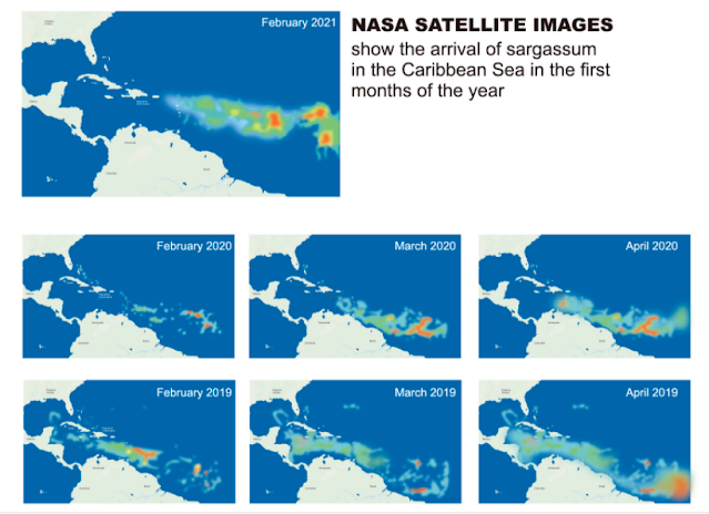
This graphic shows the accumulation of sargassum in the Atlantic.
https://stthomassource.com/content/2021/04/16/sargassum-brown-tide-threatens-the-caribbean/
-------------------------------
The Issue Explained: Sargassum in the Caribbean
October 7, 2019
https://www.caymancompass.com/2019/10/07/the-issue-explained-sargassum-in-the-caribbean/
-------------------------------
Illegal dumping of kelp causing ecological damage in Mexican Caribbean
Jul 28, 2019

(View of boats on July 24, 2019, collecting some of the tons of seaweed, or kelp, that collects each day along the beach at Playa del Carmen, in Mexico's Quintana Roo state on the Yucatan Peninsula. Illegal dumping of the kelp in local forests and rivers is ruining the local ecosystem).
Thousands of tons of kelp collected in recent months in Puerto Morelos, in Mexico's Quintana Roo state on the Yucatan Peninsula are being illegally dumped in jungle zones and into rivers, putting the local ecosystem at risk.
According to what experts told EFE, the approximately 40 tons of kelp gathered each day at the tourist resort are being taken to illegal rubbish dumps, an environmental crime that violates federal regulations.
When the macro-algae piles up in a certain spot, what leaches out of it during the decomposition process filters into the subsoil, as documented by researchers from the National Autonomous University of Mexico's (UNAM) Ocean Sciences and Limnology Institute.
These leachates include ammonium, nitrogen, phosphorus, arsenic and sulfuric acid, as well as heavy metals like lead and even gold.
All these elements and compounds are being leaked into the region's underground watercourses, UNAM's Rosa Rodriguez-Martinez told EFE on Sunday.
Personnel from the Puerto Morelos Public Services Council and the Dakatso company have been working together since May to collect the seaweed as it washes up along the coast - which is a prime tourist spot.
Right at the beginning of the so-called Ruta de los Cenotes (Cenotes Route - a "cenote" being a water-filled pit or basin), a big tourist destination four kilometers (2.5 mi.) from the Caribbean coast, is one of the sites where tons of the marine plant have been dumped over the past year, seriously affecting the region, causing losses to the hotel sector and resulting in additional costs to clean up the local beaches.
Along this route runs a complex river network that, according to the city's Urban Development Plan, is an important rainfall capture zone.
Since 2015, the Environment and Natural Resources Secretariat (Semarnat) has set the general parameters and guidelines for removing kelp from Mexico's Caribbean beaches.
"The (dumping) will be performed at sites and in ways authorized by the responsible authority (Semarnat and the municipality)," is the language on page 12 of the regulation.
In 2018, the Environment Secretariat (SEMA) established seven final dumping sites that, despite the increasing tonnage of collected kelp, were reduced to five earlier this year, one of them being right in Pueto Morelos.
But if you ask Dakatso workers why they don't take the kelp to the nearby official dump, they reply that it's full and so they decided to change the dumping site.
Neither the official site nor the new one are outfitted with environmental protection to prevent leakage, that is to say a membrane of impermeable material.
When specifically asked about it, the Dakatso Group's director, Dagoberto Ruiz Lavin, denied the illegal dumping, arguing that the firm's eight-month contract does not specify the kelp's final destination.
It has been verified on several occasions, however, that Dakatso personnel fill a city truck with the kelp, drive it to the Ruta de los Cenotes and empty it there. Some of the water in the cenotes eventually makes its way underground to the ocean, carrying the pollutants from the seaweed.
And according to a recent UNAM study, the combination of materials coming from the kelp creates low-oxygen conditions in the water, which has caused the death of members of 78 species.
Eutrophication - the chemical change in the water created by excess nutrients from the decomposing kelp - has also killed off more than 30 percent of the world's second-most-important reef system off the coast of Quintana Roo, Maria del Carmen Garcia Rivas, the head of the Puerto Morelos National Reef Park, told EFE.
-------------------------------
Caribbean islands face loss of protection and biodiversity as seagrass loses terrain
September 24, 2020
https://phys.org/news/2020-09-caribbean-islands-loss-biodiversity-seagrass.html
Tropical islands have an important ally when it comes to battling storms and sea-level rise: seagrass. During hurricane Irma, an extremely powerful Category 5 storm that hit the North Caribbean in 2017, NIOZ scientist Rebecca James witnessed how native seagrass meadows along the coast of Sint Maarten held their ground, reduced coastal erosion and lowered the chances of flooding. In the years of research during her Ph.D., she saw the pressures on this natural storm protection increasing. In her dissertation, The future of seagrass ecosystem services in a changing world, James warns that further loss of these green meadows will leave tropical islands vulnerable and will exacerbate the negative effects of climate change
The flexible grass, that grows in shallow bays and lagoons throughout the Caribbean, is a natural wave dampener. As it sways back and forth, it removes energy from the waves, keeps the sand on the seafloor stable and, thereby, protects the beach against erosion. James says, "It is a great natural protector of beaches and reduces the need for human intervention, such as sand nourishments and seawalls."
Guardian of biodiversity
Seagrass offers more than protection to the islands and its people. The underwater meadows form a rich environment in which marine life, from micro-organisms to large animals, thrive. In turn, this benefits the local fishing communities. James: "In science, we call these ecosystem services." And seagrass serves many. James notes, "Through photosynthesis, seagrass removes CO2 from the water, it provides food and shelter for fish, turtles and sea urchins." Loss of these meadows not only puts tropical beaches at risk from erosion, it threatens all the species that rely upon them.
The biggest threats come from human disturbance, invasive species and bad water quality on the coasts. James says, "Tourists flock to the Caribbean for the beautiful beaches and clear waters. Resorts, restaurants and bars have been built throughout the Caribbean to support tourism, however, often at the expense of the natural environment." Dunes had to make way for hotels, seagrass -and seaweed were removed to create perfectly groomed beaches, feet trample the meadows, and boat anchors leave scars; physical damage that takes years to recover.
A healthy seagrass ecosystem depends on healthy neighbors. And the grasses suffer under the damage done to nearby coral reefs or inland mangroves. "Coral reefs, mangroves and seagrass meadows are vital for a healthy Caribbean Bay. The systems are strongly connected and benefit each other," James comments. Animals move between the corals and seagrass meadows depending on their need for food or protection from predators or waves. Mangroves filter sediment that runs from the land into the ocean, improving water quality and clarity. James says, "With more people comes more wastewater, which reduces the water quality when there isn't sufficient water treatment." Over the years, more and more mangroves had to make way for farming and housing. With little left behind to capture the sediment, the water in the bays turns cloudy and dirty.
Restoring what was lost
As the pressure on seagrass increases from different directions, the importance of an integrated approach to protection, conservation and restoration becomes clear. "My more recent research shows that overgrazing by turtles and an invasive seagrass species (Halophila stipulacea) that is currently spreading around the Caribbean, reduce the coastal protection services. This example shows the importance to match conservation efforts of turtles with conservation of their habitats, says James."
To mitigate the negative effects of climate change and protect the biodiversity in our oceans, there is a great need for the natural self-sustaining strategies that seagrass meadows provide. However, James warns that in ecosystems it is not that simple to get back what was once lost. She points out that "Only 37% of seagrass restorations have survived. Projects like these take time, money and support from local communities and stakeholders. Working in coastal areas, waves and storms can undo hours of intensive restoration labor."
James urges that we need to act fast to improve the health of seagrass ecosystems. "Only healthy ecosystems have a chance of withstanding the more extreme weather events, a rise in CO2, and rising temperature that come with climate. The rapid rate of this change gives us, and present-day ecosystems, little time to adapt to the new climatic conditions on earth. Yes, it will require substantial investments in resources and money, but the benefits will go far beyond coastal protection."
-------------------------------
Research shows long-term recovery possible for areas impacted by seagrass die-off
April 30, 2021
https://phys.org/news/2021-04-long-term-recovery-areas-impacted-seagrass.html
---------------------------------------
-------------------------------------
----------------------------------
--------------------------------
-------------------------------
Section 3: Communism, Slavery, Politics & Environment
-------------------------------
--------------------------------
----------------------------------
-------------------------------------
----------------------------------------
Cuba
https://www.britannica.com/place/Cuba/Sugarcane-and-the-growth-of-slavery
-------------------------------
White Jamaicans
https://en.wikipedia.org/wiki/White_Jamaicans
White Jamaicans also known as Euro-Jamaicans are Jamaicans whose ancestry lies within the continent of Europe, most notably Great Britain, Ireland, Spain, Germany and Portugal. In 2018, the population was said to be 12,382 people, equating to 0.4% of the overall population. Historically White Jamaicans made up a much larger percentage of the population, forming a majority for most of the 17th century.
Demographic history
The proportion of white people among the overall population in Jamaica has varied considerably since the establishment of a permanent Spanish settlement in 1509 by Juan de Esquivel. The native Taíno people were virtually extinct by 1600 and the island's population of about 3,000 was then overwhelmingly European. However, over the next century a significant numbers of African slaves were brought to the island. Jamaica became a colony of England in 1655 and a census in 1662 recorded 3,653 whites (87% of the population) and 552 blacks (13% of the population). However, by 1673 there were 7,768 whites (45% of the population) and 9,504 blacks (55% of the population). By the end of the century only about 7,000 out of a total population of 47,000 (or 15%) were white. Most white immigrants were British, many coming voluntarily from other North American colonies or as refugees from colonies like Montserrat and Suriname, which were captured by other European powers.
By 1734, the proportion of white people had decreased to below 10% of the overall population of Jamaica. In 1774, Edward Long estimated that a third of Jamaica's white population were Scottish, mostly concentrated in Westmoreland Parish. In 1787, there were only 12,737 whites out of a total population of 209,617. There was a flow of French refugees to Jamaica after the Haitian Revolution, though not all remained in the country. In the 1830s, over 1,000 Germans immigrated to Jamaica to work on Lord Seaford's estate. The 1844 census showed a white population of 15,776 out of a total population of 377,433 (around 4%). According to the 1871 census, at least 25% of the population was coloured (having mixed black and white ancestry).
The 1960 census recorded a white population of 0.77 percent, which decreased to 0.66 in 1970, 0.18 in 2001, and 0.16 in 2011.[9] As with most Anglo-Caribbean countries, most Jamaicans who are of mixed ancestry self-report as 'black'. In 2011, the CIA World Factbook estimated that the population of Jamaicans who are of mixed European and African ancestry is at about 96%.
-------------------------------
Slavery in Cuba
https://en.wikipedia.org/wiki/Slavery_in_Cuba
Slavery in Cuba was a portion of the larger Atlantic Slave Trade that primarily supported Spanish plantation owners engaged in the sugarcane trade. It was practiced on the island of Cuba from the 16th century until it was abolished by Spanish royal decree on October 7, 1886.
The first organized system of slavery in Cuba was introduced by the Spanish Empire, which attacked and enslaved the island's indigenous Taíno and Guanahatabey peoples on a grand scale. Cuba's original population was eventually destroyed completely, partly due to this lethal forced labor throughout the course of the 1500s.[citation needed]
Following the native genocide, the Spanish were in need of new slaves to uphold their sugarcane production. They thus brought more than a million enslaved African people to Cuba. The African enslaved population grew to outnumber European Cubans, and a large proportion of Cubans today are descended from these enslaved peoples - perhaps as much as 36% of the population.[dubious – discuss]
Cuba became one of the world's largest sugarcane producers after the Haitian Revolution and it continued to import enslaved Africans long after the practice was internationally outlawed. Cuba would not end its participation in the slave trade until 1867, nor abolish slave ownership until 1880. Due to growing pressure on the trade throughout the 19th century, it also imported more than 100,000 Chinese indentured workers to replace dwindling African labor.[citation needed]
-------------------------------
Slavery and the Jews
A review of The Secret Relationship Between Blacks and Jews: Volume One
1995
https://www.theatlantic.com/magazine/archive/1995/09/slavery-and-the-jews/376462/
-------------------------------
Atlantic Magazine Admits Jewish Role in Slave Trade
March 12, 2018
https://noirg.org/articles/atlantic-magazine-admits-jewish-role-in-slave-trade/
-------------------------------
Dutch Jews and the slave trade
January 3, 2014
https://jewishstandard.timesofisrael.com/dutch-jews-and-the-slave-trade/
On the Caribbean island of Curacao, Dutch Jews may have accounted for the resale of at least 15,000 slaves landed by Dutch transatlantic traders, according to Seymour Drescher, a historian at the University of Pittsburgh. At one point, Jews controlled about 17 percent of the Caribbean trade in Dutch colonies, Dr. Drescher said...
-------------------------------
Jewish Role in African Slave Trade Admitted by Rabbi in New Jewish Book
December 31, 2013
https://davidduke.com/jewish-role-african-slave-trade-highlighted-new-dutch-jewish-book/
-------------------------------
Jewish involvement in the transatlantic slave trade a “canard?”
March 6, 2014
https://davidduke.com/jewish-involvement-transatlantic-stave-trade-canard/
-------------------------------
Jewish Dominance Of The African Slave Trade
February 3, 2020
https://christiansfortruth.com/jewish-dominance-of-the-african-slave-trade/
-------------------------------
Jews Admit Jewish Role In Black Slave Trade. Update 2
December 2019
http://www.covenersleague.com/component/k2/item/576-jews-admits-jewish-role-in-black-slave-trade-update-2
-------------------------------
Jews, Slaves and the Slave Trade: Setting the Record Straight
https://en.wikipedia.org/wiki/Jews,_Slaves_and_the_Slave_Trade:_Setting_the_Record_Straight
-------------------------------
Jews and the American Slave Trade
https://en.wikipedia.org/wiki/Jews_and_the_American_Slave_Trade
Jews and the American Slave Trade is a 1998 book by American historian Saul S. Friedman published by the Transaction Publishers. It focuses on the Jewish involvement in the American slave trade and is a polemical rebuttal against the 1991 work The Secret Relationship Between Blacks and Jews. It has also been described as contributing to the contemporary debates related to African American–Jewish relations.
-------------------------------
Deadly Bigotry: When Canada, America & Cuba Rejected Jewish Refugees before WW2
Dec 26, 2018
https://www.warhistoryonline.com/instant-articles/rejected-jewish-refugees.html
Hitler’s extreme anti-Semitism was coming to a head when over 900 Jews bordered the MS St. Louis in an effort to escape from Germany just months before World War 2 began.
They were desperate to save themselves and their families and hoped that they would find salvation in the Americas. They left Hamburg in May 1939, only seven months after Kristallnacht.
Despite the fact that anybody who was paying attention could tell that Hitler’s anti-Semitism was far more than just rhetoric, Canada, the United States, and Cuba would all harden their hearts and reject the refugees.
-------------------------------
How Castro Saved Cuba's Kosher Butcher
Nov. 27, 2016
Armed with a personal letter from the communist leader, the Havana butcher has been providing meat to the tiny Jewish community for decades.
https://www.haaretz.com/world-news/americas/.premium-how-castro-saved-cuba-s-kosher-butcher-1.5335519
-------------------------------
The Jews Behind Fidel Castro and the Cuban Communist Party
September 28, 2020
https://nationalvanguard.org/2020/09/the-jews-behind-fidel-castro-and-the-cuban-communist-party/
THE Cuban Communist Party, or the Partido Comunista de Cuba (hereafter PCC), is the organisation that preceded the development of the broad left-wing revolutionary movement that transformed into the late Fidel Castro’s communist government, and which was then recreated to support the government.
I have previously discussed both the likely possibility that Fidel Castro and his powerful brother Raul Castro are themselves of partial Jewish descent (1) — and are very aware of it (2) — as well as the fact that Cuba and Israel have long had a very strange diplomatic relationship. (3)
Previously, I have argued that the latter is likely to be at least partially the result of the former.
Here I would like to expand upon the largely unknown but extremely important relationship between the PCC and the Jews. To begin with, I think it is apt to quote Richard Gott’s summary of the early history of the PCC.
To wit:
‘An embryonic Communist Party, formed in 1925 by socialists attracted to the Russian revolution, was eventually strong enough to take over the CNOC in 1931. Several of the more prominent Cuban communists were Jews from Eastern Europe — a fresh input into Cuba’s ethnic mix — some of whom still found it easier to speak Yiddish rather than Spanish. One of them, Yunger Semjovich, was to survive into the early years of the Revolution in 1959, under the name of Fabio Grobart. Distrust of the communists as ‘foreign’, ‘Jewish’ and beholden to Moscow was one of the obstacles facing the party, distrust as prevalent on the nationalist left as on the right.’ (3)
To be more specific: three of the ten founders of the PCC in 1925 were Jewish. (5) The rest, as Simons has noted, were left-wing Cuban intellectuals. (6)
In order to give context to this situation, it is important to note that in 1924 there were only 24,000 Jews in Cuba out of a total population, as recorded in the 1931 Cuban census, of 3,962,344. This equates to Jews representing only 0.6 percent of the Cuban population.
Therefore the fact that three out of the ten founders of the PCC (i.e. thirty percent) were Jewish, while not conclusive it is suggestive that Jewish involvement with the PCC was significant.
Indeed, one of these three founders, Yunger Semjovich aka Fabio Grobart, (7) was in many ways the old man of communism in Cuba between 1925 and 1959. When in 1944 the PCC transformed itself into the Partido Socialista Popular (i.e. Popular Socialist Party or PSP), Grobart was one of the party leaders who made and carried out the decision.
The PSP formed the corner stone of the revolutionary movement in Cuba during the 1940s and early 1950s. Only with the emergence of the Revolutionary Directory student movement lead by Faure Chomon and Fidel Castro’s 26th of July Movement (hereafter M26J) did this begin to change.
When Castro arrived back in Cuba from Mexico in November 1956, he did so on board the yacht Granma, the money for which had been donated by a Jew. (8) When he emerged victorious in the 1959 Cuban revolution, he had the support of Grobart’s PSP as well as the Revolutionary Directory and, most importantly, his M26J group.
The M26J movement also included among its senior commanders one Enrique Oltuski Osacki — born in Cuba in 1930 to Polish Jewish immigrant parents — (9) who served as a vital link between the M26J guerrillas and the primarily urban movements of the Revolutionary Directory and PSP. (10) In addition to this, Osacki served as the head of the M26J movement in the central Las Villas province. (11)
It is also a well-established, but not widely known fact that the M26J was funded by Castro’s long-time friend Ricardo Subirana Lobo, aka Richard Wolf, who was a Cuban Jew. (12)
Once Batista had been toppled in 1959, Osacki was appointed as the Minister of Communication and was one of the three M26J representatives in the new Cuban cabinet. (13) In 1960, he was subsequently appointed as Che Guevara’s deputy in the Department of Industrialisation and then joined the Central Economic Planning Board (JUCEPLAN). (14) As of 2009 he was Vice Minister for Fishing. (15)
After the failed Bay of Pigs invasion in April 1961, Fabio Grobart was one of the most trusted of Fidel’s confidants and government officials. (16) As late as 1986 Grobart was still a very prominent and influential Cuban communist leader, in the third Cuban Party Congress in that year it was Grobart who introduced Casto to the delegates. (17)
Richard Wolf predictably became Castro’s ambassador to Israel in 1960 and successfully promoted trade and scientific exchanges, which allowed Cuba to break the US blockade of the country. (18)
These weren’t the only members of Cuba’s Jewish population who supported and benefited from Castro’s communist revolution — Manual Stolik Novigod, a Jew who became one of Castro’s top diplomats is yet another example — (19) but the foregoing discussion clearly demonstrates that, as 0.6 percent of the Cuban population at the time, Jews played a significant and disproportionate role in bringing about the murder and terror that has accompanied Castro’s rule in Cuba.
Put it this way: Jews bankrolled Castro’s M26J group, one of Castro’s key commanders was a Jew, the long-time head of the ‘official communist party’ in Cuba and a Castro ally was a Jew and Castro believed himself to be of Jewish ancestry.
Taking into consideration the population demographics of Cuba and how small the Jewish community in the country was at the time (0.6 percent of the population), it would have been difficult for Castro’s communist revolution to have been more Jewish than it in fact was.
-------------------------------
The Jews Behind Fidel Castro and the Cuban Communist Party
October 07, 2020
https://www.freedomofspeechtwentyfirstcentury.com/2020/10/the-jews-behind-fidel-castro-and-cuban.html
-------------------------------
Cuba's Jews Under Castro: 'If It Will Be Better for Cuba, It Will Be Better for Jews'
Nov. 26, 2016
With Castro's passing, a look at the challenges endured and privileges enjoyed by the small Jewish community in the Communist island.
https://www.haaretz.com/world-news/americas/cuba-s-jews-under-castro-privileged-but-poor-1.5365227
-------------------------------
7 Things About Fidel Castro and the Jews
Nov 29, 2016
https://forward.com/news/breaking-news/355516/7-moments-that-defined-castro-s-relationship-with-jews-and-israel/
Former Cuban leader Fidel Castro, whose death was late Friday, had a complicated history with Jews.
Under Castro, who seized power in 1959, and his brother Raul Castro, who took over as president in 2008, Jews in Cuba were extended religious freedoms and received special rations from the government for kosher meat. But the former Cuban leader also frequently expressed hostile views on Israel.
Here are some of Castro’s defining moments with Jews and Israel — as reported by JTA throughout the years.
1962: Jews reportedly make up some of Castro’s post Bay-of-Pigs prisoners of war
Some prisoners of war who took part in the failed, CIA-sponsored Bay of Pigs invasion (launched by the paramilitary expatriate group Brigade 2506 on April 17, 1961) were reportedly Jews whose parents had arrived in Cuba after fleeing Nazi Germany. These Jewish boys “are perhaps the saddest among the prisoners,” because their parents had felt “the heel of a dictator twice in one generation,” said James Donovan, an attorney working to free the prisoners (later portrayed by Tom Hanks in the film “Bridge of Spies”).
1979: Castro attacks Israel at U.N., Israeli envoy calls him an enemy of Israel
The Cuban leader accused Israel of committing “the most terrible crime of our era” against the Palestinians in front of the U.N.’s General Assembly. Israel’s envoy rebuked Castro, saying the Cuban leader had “joined the shrill hue and cry already raised in the [Assembly’s] general debate by the enemies of peace in the Middle East.”
1999: Cuban Jews secretly immigrate to Israel — with Castro’s blessing
About 400 Cuban Jews left their country for the Jewish state in 1995-1999 — and though ties between Cuba and Israel were nonexistent, apparently Castro didn’t mind. The Jewish Agency for Israel was said to have gotten Castro to agree to not make a fuss about “Operation Cigar” by agreeing to keep it on the down-low. Canada, which maintained political relations with Cuba, had also reportedly helped Cuban Jews immigrate to Israel.
2008: Cuban Jews expect little change in policy following Castro ****step-down
As Castro stepped down, Jewish Cuban emigres did not expect a change in policy, anticipating that his brother Raul would likely keep the status quote of granting relative religious freedom to Jews while being harsh on Israel. “This means absolutely nothing for the Cuban Jewish community,” said one Cuban Jewish exile.
2009: Castro can’t grapple with Rahm Emanuel’s ‘strange surname’
Castro penned a column for a Cuban newspaper dedicated to musings about U.S. President Barack Obama’s chief of staff. “It appears Spanish, easy to pronounce, but it’s not. Never in my life have I heard or read about any student or compatriot with that name, among tens of thousands,” he wrote of Emanuel’s name, which means “God is with us” in Hebrew.
2010: Castro slams Iran’s Ahmadinejad Holocaust denial, anti-Semitism
“The Jews have lived an existence that is much harder than ours. There is nothing that compares to the Holocaust,” Castro, a frequent critic of Israel, said in an interview with Jewish-American reporter Jeffrey Goldberg, in which he criticized the Iranian leader for denying the Holocaust and perpetuating anti-Semitism. He also said he thinks Jewish culture and religion had kept the Jewish people “together as a nation.”
2014: Castro describes Israel’s Gaza offensive as a “Palestinian Holocaust”
In line with previous harsh criticism of the Jewish state, the former Cuban leader called Israel’s Operation Protective Edge a “new, repugnant form of fascism” in a column titled “Palestinian Holocaust in Gaza.” “Why does the government of this country [Israel] think that the world will be impervious to this macabre genocide that is being committed today against the Palestinian people?” the former Cuban leader wrote.
-------------------------------
Jews and Puerto Rico: 7 Facts
Oct 1, 2017
https://www.aish.com/jw/s/Jews-and-Puerto-Rico-7-Facts.html
-------------------------------
History of the Jews in Cuba
https://en.wikipedia.org/wiki/History_of_the_Jews_in_Cuba
Jewish Cubans, Cuban Jews, or Cubans of Jewish heritage, have lived in the nation of Cuba for centuries. Some Cubans trace Jewish ancestry to Marranos (forced converts to Christianity) who came as colonists, though few of these practice Judaism today. More than 24,000 Jews lived in Cuba in 1924, and more immigrated to the country in the 1930s. But during and after the 1959 communist revolution, 94% of the Jews left for the United States and other countries. In 2007 an estimated 1,500 known Jewish Cubans remained in the country, overwhelmingly located in Havana, occasionally called Jubans as a portmanteau of the English word "Jew" and Cuban. Several hundred have since emigrated to Israel.
After the Cuban Revolution
In the aftermath of the revolution, nearly 95% of the Jewish population left Cuba for the United States, many settling in Miami. By September 1960, as many as 3,000 Jews had already departed Cuba and approximately 1,500 remained by 1997. Additionally, between the years 1948 and 1997, 661 Cuban Jews immigrated to Israel and in 1999 another 400 Cuban Jews departed for Israel as well.
Many Jews were initially sympathetic to the Cuban Revolution of 1959 under Fidel Castro, seeing the change in leadership as an opportunity to rid Cuba of the corruption that was associated with the dictatorship of Fulgencio Batista. In the early stages of the revolution, it was not evident that Castro's plans were to ally Cuba with the communist bloc. As Castro's plans became clear, Jewish Cubans who had emigrated from Eastern and Central Europe became increasingly concerned with the impending revolution, as a result of their prior experience with religious intolerance associated with Leninist policies and Bolshevik Russia. During the earliest days of the revolution, the most paramount concern for the Jewish Cuban population was the nationalization of industry and agriculture and the laws which supported it. These measures include the first and second Agrarian Reform Laws, Law 851, and the First Urban Reform Law. The Agrarian Reform Laws of 1959 and 1963 caused strife amongst Jewish landowners and farmers, as the government began eradicating all landed estates and foreign owned land, in addition to nationalizing all properties and buildings exceeding 67 hectares. The Law 851 sparked the nationalization of business and industry within Cuba, beginning with foreign owned businesses. It entailed the expropriation of Cuban property, not owned by leaders of a previous government, for the first time in Cuba's history. This ranged from large to medium sized businesses, including distilleries, factories, and department stores. Finally, the First Urban Reform Law stripped Jews of their property rental business by turning ownership to tenants and creating longterm rent-free leases. This law also made it illegal to privately rent or sublet properties.
Jews faced underlying anti-Semitism as a result of revolutionary policies and rhetoric during the Cuban Revolution. This prejudice was carried out by measures such as the second Urban reform law, which permitted the Cuban government to seize the property and assets of those who immigrated to the island. Individuals were barred from joining the Cuban Communist Party and did not have the ability to study at a university, simply because they were Jewish. The language used to describe Jews included, “Judio” for children who were not baptized, “Turquista”, and "Polaco" or "Polaquito" which were synonymous with Jew, regardless of their country of origin. Lastly, during their emigration from Cuba to Israel, Jews were marked as “repatriado” (repatriated) on their passport rather than “gusanos” (worms) as an emigration distinction. This was meant to indicate that those Jews departing for Israel to be “repatriated to their home country”, though few Jews who immigrated to Cuba were actually Israeli.
In 1959, the government declared that the revolution would be a socialist movement and that Cuba would become an atheist state. This shunning of religion helped shaped the religious identity of Jews who remained in Cuba, as well as the exiles who emigrated to the United States, Israel, and other areas throughout North, South, and Central America. The Jewish Cuban identity was morphed by a variety of revolutionary influences, but particularly the bias against those who practiced any faith other than Marxism. Those who remained in Cuba either shied away from participation in the revolution or chose to abandon their Jewish identity altogether in order to do the opposite. Up until 1992 when Cuba had adjusted its constitution to reflect that the country was no longer an atheist state but rather secular or "la apertura", Jews had largely discarded their uniquely Jewish practices and abandoned community gathering at places such as El Patrono community center and Chevet Ahim synagogue. For many Cuban Jews, eating Matzo, an unleavened bread eaten during the celebration of Passover, was the only practice they had maintained.
Three of the ten original members of the Cuban Communist Party were Jewish including Fabio Grobart, Manuel (Stolik) Novigrod, and Enrique Oltuski. Fabio Grobart, whose original name was Abraham Simchowitz, immigrated from Poland to Cuba at the age of 19 and brought along with him knowledge of the radical leftist movements from Eastern Europe. He joined the Cuban Communist Party in 1925 and was one of Castro's closest constituents as a member of the party's Central Committee. He represented the party in communist ideology, as he had the ability to translate the readings of Karl Marx and Frederick Engels from Russian and German to Spanish. Manuel (Stolik) Novigrod was born into a family of Jewish communists and fought directly alongside Castro against Bautista's forces in the Sierra Maestra Mountains. One year after his parents' immigration from Poland, Enrique Oltuski was born in Cuba in 1930. His collaboration with Ernesto "Che" Guevara while representing Las Villas as its leader of the 26th of July Movement enabled him to ascend to highest-ranking Jew in the revolutionary government. Following the revolution, Oltuski was relied on, acting as the vice minister of the fishing industry, as well as working with the Ministry of Culture in order to maintain a historical account of the revolution.
In February 2007 The New York Times estimated that there were about 1,500 known Jews living in Cuba, most of them (about 1,100) living in Havana. Cuba has one kosher butcher shop on the entire island. For a time it had no rabbi, but by 2007, one was based in a Havana synagogue. He often encourages visiting Jewish peoples to give tzedakah (charity) for the Jewish Cubans and for Israel. Alan Gross traveled to Cuba to help the small Jewish community, but he was detained in Cuba from 2009 to 2014. Some Jewish Americans originally from Cuba are also fierce critics of the Cuban government, such as former Representative Ileana Ros-Lehtinen. Israel also continues to have an embargo against Cuba.
Adath Israel is the only nominally Orthodox synagogue remaining in Cuba. There are two other synagogues in Havana, in addition to a few other Cuban cites. In December 2006, the Cuban Jewish community celebrated its 100th anniversary.
In 1999, actor and playwright Frank Speiser debuted his one-man play Jewbano about growing up Jewish and Cuban in Brooklyn. Although primarily used in a positive sense, some confusion has arisen in the past where "Jewban" has been misinterpreted as an ethnic slur, or as a political statement (i.e. suggesting the "ban" of Jews). In 2003 the Florida Department of Highway Safety and Motor Vehicles attempted to withdraw a "JEWBAN" vanity plate which had previously been issued to Tabares Gomer, a Jewish Cuban, arguing that the plate could be considered anti-semitic. The department later relented and permitted Gomer to keep the license plate.
-------------------------------
The Jewish Community in Cuba Before the Revolution
May 16, 2014
https://cri.fiu.edu/research/commissioned-reports/jews-in-cuba.pdf
-------------------------------
Ship carrying 937 Jewish refugees, fleeing Nazi Germany, is turned away in Cuba
1939
https://www.history.com/this-day-in-history/ss-st-louis-jewish-refugees-turned-away-holocaust
-------------------------------
Jews fleeing Cuba made Miami their home. Now a synagogue they built is struggling.
February 4, 2020
https://www.jta.org/2020/02/04/united-states/jews-fleeing-cuba-made-miami-their-home-now-a-synagogue-they-built-is-struggling
-------------------------------
A Ship of Jewish Refugees Was Refused US Landing in 1939. This Was Their Fate
https://www.history.com/news/wwii-jewish-refugee-ship-st-louis-1939
As the M.S. St. Louis cruised off the coast of Miami in June 1939, its passengers could see the lights of the city glimmering. But the United States hadn’t been on the ship’s original itinerary, and its passengers didn’t have permission to disembark in Florida. As the more than 900 Jewish passengers looked longingly at the twinkling lights, they hoped against hope that they could land.
Those hopes would soon be dashed by immigration authorities, sending the ship back to Europe. And then, nearly a third of the passengers on the St. Louis were murdered.
Most of the ship’s 937 passengers were Jews trying to escape Nazi Germany. Though World War II had not yet begun, the groundwork for the Holocaust was already being laid in Germany, where Jewish people faced harassment, discrimination and political persecution. But though the danger faced by the passengers was clear, they were turned down by immigration authorities, first by Cuba, then the United States and Canada. For many on the St. Louis, that rejection was a death sentence.
The voyage took place as German persecution of Jews reached a fever pitch. After Adolf Hitler took power in 1933, Germany embraced a series of laws that isolated Jewish people from daily life, by restricting their ability to move freely, shutting down their businesses and slashing educational opportunities. In November 1938, Kristallnacht, a state organized pogrom known as the “night of broken glass," left Jewish businesses, homes and places of worship in shambles.
-------------------------------
Jews Reported Among Prisoners of War Held by Castro in Cuba
November 26, 1962
https://www.jta.org/1962/11/26/archive/jews-reported-among-prisoners-of-war-held-by-castro-in-cuba
-------------------------------
CubaBrief: Cuban Communist Party's war on religion measured by destroyed churches, jailed pastors, and Jewish children barred from wearing their kippahs
November 10, 2020
https://www.cubacenter.org/archives/2020/11/10/cubabrief-cuban-communist-partys-war-on-religion-measured-by-destroyed-churches-jailed-pastors-and-jewish-children-barred-from-wearing-their-kippahs
-------------------------------
Jews Arrested, Injured, Accused As Communists in Cuba Riots, Turmoil
October 10, 1933
https://www.jta.org/1933/10/10/archive/jews-arrested-injured-accused-as-communists-in-cuba-riots-turmoil
Government parties and press are spreading agitation among the people of Havana and the military forces are blaming the Jews for carrying on Communist propaganda throughout Cuba. According to the conservative press, the Jews are responsible for all the ills that have afflicted Cuba. The morning paper La Manana reports on the authority of the Havana chief of police that the Jews are disturbing the life of Cuba and that the Jews in Cuba are leading immoral lives.
House-to-house searches are being carried out on the pretext that arms and Communist literature have been secreted in them.
Ii the course of a labor demonstration, the Jewish worker Abraham Duge was mortally wounded and the merchant Weintrob was almost shot when he was falsely accused of firing on the troops from the roofs of his house.
The Jews Gasman, Rubin and Eweshtein were arrested on various pretexts and are in danger of being deported.
The Jewish student Moses Raigorodsky was arrested and charged with being a Communist leader. His father, owner of a printing press, was also arrested.
Havana Jewish institutions have called a special meeting and created a Jewish committee to clear the Jews of Cuba of the accusations made against them.
The newly created committee plans to intervene both with President Grau San Martin and with the Cuban chief-of-staff, Colonel Batista. Unrest pervades the Jewish colony in Cuba. Business is completely paralyzed. It is thought that Hitlerism is to be partially blamed for the propaganda against the Jews. The Germans resident in Cuba are thought to be the initiators of the anti-Jewish propaganda.
-------------------------------
Reporter’s notebook: Celebrating 90 years of Jewish community in Guantanamo
June 28, 2019
https://www.jweekly.com/2019/06/28/reporters-notebook-celebrating-90-years-of-jewish-community-in-guantanamo-cuba/
-------------------------------
The lesser-known fate of Jewish refugees in Cuba
29.10.2012
Ursula Krechel's prize-winning novel "District Court" illuminates a previously little-known chapter in 20th-century history: The exile of Jewish refugees in Cuba. DW talked to Michael Zeuske, an expert on Latin America.
https://www.dw.com/en/the-lesser-known-fate-of-jewish-refugees-in-cuba/a-16339656
-------------------------------
‘Jewbans’ prosperous in America, while brethren in Cuba ‘hangs on the precipice’
November 13, 2020
https://www.jns.org/jewbans-prosperous-in-america-while-brethren-in-cuba-hangs-on-the-precipice/
-------------------------------
©THE JUBANOS, the JEWS of Cuba * Los Jubanos, los judios de Cuba.
June 2, 2013
https://www.thecubanhistory.com/2013/06/the-jubanos-los-jews-of-cuba-los-jubanos-los-judios-de-cuba/
-------------------------------
We found strength, camaraderie and happiness among Cuba’s Jews
February 3, 2020
https://www.jweekly.com/2020/02/03/we-found-strength-camaraderie-and-happiness-among-cubas-jews/
-------------------------------
Multiple Diasporas: Jews in Cuba, Cuban Jews in Miami
2014
https://cri.fiu.edu/events/2014/multiple-diasporas-jews-in-cuba-cuban-jews-in-miami/
-------------------------------
Antisemitism rises among Hispanic Miami’s right wing
April 27, 2021
https://forward.com/news/468551/antisemitism-rises-among-hispanic-miamis-right-wing/
-------------------------------
Latin Jews finding a home in South Florida
March 11, 2005
http://www.latinamericanstudies.org/religion/latin-jews.htm
-------------------------------
Cuba’s Jewish Community is dwindling
Oct 19, 2014
https://blogs.timesofisrael.com/cubas-jewish-community-is-dwindling/
-------------------------------
Just how Jewish are Latinos?
Apr 19, 2019
https://www.youtube.com/watch?v=EDylfZcvfws
-------------------------------
Jewish Immigration to Argentina
Movements Before 1930
https://library.brown.edu/create/modernlatinamerica/chapters/chapter-9-argentina/moments-in-argentine-history/jewish-immigration-to-argentina/
Jorge Luis Borges aptly wrote: “The Argentines are Italians who speak Spanish, educated by the British, who want to be French.” In this amalgamation of European cultures, where do the tens of thousands of Jewish immigrants to Argentina fit in?
From the late nineteenth century to the early twentieth, six million people flowed into Argentina. In the first two decades of the twentieth century, the foreign-born population outnumbered native Argentines. On the eve of the First World War, Buenos Aires was the second largest city on the Atlantic seaboard after New York.
Along with masses of Spaniards and Italians arrived Jewish immigrants from Central and Eastern Europe, the Ottoman empire, and the Mediterranean. Historian Ricardo Feierstein described the early period of Jewish immigration to Argentina, from 1880 to 1920, as a “downpour.” Compared to other Latin American destinations, Jews came to Argentina relatively early, with entries peaking in the years just following the First World War. In contrast, Jews did not move to Brazil in large numbers until the mid-1920s, and they did not migrate to Bolivia or the Dominican Republic until the late 1930s. The Jews who went to Buenos Aires and the Argentine interior between 1880 and 1920 formed the first sizable Jewish presence in Latin America.
In this period, however, Jews did not form a solid ethnic or religious community. Between 1880 and 1920, the Jewish community was largely decentralized; many of the Jews were secular and did not congregate around a synagogue. They connected instead through language, traditions, and political beliefs.
Many of the Jews arriving in this period already held left-leaning worldviews that manifested through political activism. In Argentina, Jews encountered a politically heated climate in which the working classes had mobilized in support of anarchism and socialism. Some Jews participated in anarchist movements, the most popular ideology among the masses in Argentina between 1905 and 1915. A major anarchist daily newspaper in Buenos Aires, La Protesta, included a Yiddish supplement in its issues during 1908. But Jews participated in even larger numbers in communist, socialist, and Zionist organizations. In 1906 a group founded the first Jewish union, and one year later established the Organización de Trabajadores Socialistas Demócraticos Judíos (Organization of Jewish Socialist Democratic Workers), which voted to align themselves with the Bundist movement, a Jewish sector of socialism. This group formed teaching institutions for youth, providing a secular education in a Jewish social environment. Organizations also sponsored cultural activities, which gave new immigrants an opportunity for socialization and “a measure of companionship and social support.”
-------------------------------
Mission to Communist island: Maine group to forge ties with Cuba’s Jews
March 9, 2015
https://www.pressherald.com/2015/03/09/mission-to-communist-island-maine-group-to-forge-ties-with-cubas-jews/#
-------------------------------
Mass Firing of Cuban Media that Claimed George Soros Is a Wealthy Influential Jew
March 6, 2019
https://christiansfortruth.com/mass-firing-of-cuban-media-who-claimed-george-soros-is-a-wealthy-influential-jew/
-------------------------------
CUBAN JEWISH JEWS CUBA
https://www.pinterest.com/abrahamdiner/cuban-jewish-jews-cuba/
-------------------------------
Communist Party of Cuba
https://en.wikipedia.org/wiki/Communist_Party_of_Cuba
The Communist Party of Cuba[note 2] is the ruling political party in the Republic of Cuba. The Cuban constitution ascribes the role of the party to be the "leading force of society and of the state". It was founded on 3 October 1965 as a successor of the United Party of the Cuban Socialist Revolution, which was in turn made up of the 26th of July Movement and Popular Socialist Party that seized power in Cuba after the 1959 Cuban Revolution.
The PCC is a communist party based on democratic centralism, a principle conceived by Russian Marxist Vladimir Lenin, entails free and open discussion of policy issues within the party, followed by the requirement of total unity in upholding the agreed policies.[11] The highest body within the PCC is the Party Congress, which convened every five years. When the Congress was not in session, the Central Committee was the highest body. Because the Central Committee met twice a year, most day-to-day duties and responsibilities are vested in the Politburo. Since April 2021, the First Secretary of the Central Committee has been Miguel Díaz-Canel,[1] who has been serving as President of Cuba since 2018. Despite plans to retire in 2021, current Second Secretary José Ramón Machado Ventura has remained in office since 2011.[1][12] Abelardo Álvarez Gil also remains Head of the Department of Organization and Staff Policy.[1]
After taking power in Cuba in 1959, the party began gradually to introduce Marxism–Leninism, a fusion of the original ideas of German philosopher and economic theorist Karl Marx, and Lenin, guided by Joseph Stalin became formalized as the party's guiding ideology and would remain so to this day. The party pursued state socialism, under which all industries were nationalized, and a command economy was implemented throughout Cuba despite the long-term embargo by the United States. The PCC also supports Castroism and Guevarism and is a member of the International Meeting of Communist and Workers' Parties.
Ideology
Compared with other ruling Communist Parties, such as in Vietnam, China, and Laos, the Communist Party of Cuba retains a stricter adherence to the tradition of Marxism–Leninism and the traditional Soviet model.[citation needed] The party has been more reluctant in engaging in market reforms, though it has been forced to accept some market measures in its economy due to the dissolution of the Soviet Union and the resultant loss of economic subsidies. The Communist Party of Cuba has often pursued an interventionist foreign policy, actively assisting left-wing revolutionary movements and governments abroad, including the ELN in Colombia, the FMLN in El Salvador, the Sandinistas in Nicaragua, and Maurice Bishop's New Jewel Movement in Grenada.[citation needed] The party's most significant international role was in the civil war in Angola, where Cuba directed a joint Angolan/Soviet/Cuban force in the Battle of Cuito Cuanavale.[18][19] More recently, the party has sought to support Pink Tide leaders across Latin America, such as Hugo Chávez and later Nicolás Maduro in Venezuela and Evo Morales in Bolivia. Since the Cuban Revolution, the party has also followed the doctrines of Castroism (the ideology of Fidel Castro, including some elements of social conservatism and inspiration from José Martí) and Guevarism.
Medical diplomacy has also been a prominent feature of the Party's foreign policy. The party maintains a policy of sending thousands of Cuban doctors, agricultural technicians, and other professionals to other countries throughout the developing world.
Raúl Castro, since becoming the leader of the party, has campaigned to "renew" Cuba's socialist economy through incorporating new exchange and distribution systems that have been traditionally seen as "market" oriented. This has led to some speculation that Cuba may transition towards a model more similar to that of China and that of Vietnam.
-------------------------------
Communism still overpowers Cuba, a visit reveals
November 30, 2016
https://www.usatoday.com/story/opinion/2016/11/30/communism-still-overpowers-cuba-visit-reveals/94595494/
-------------------------------
Meet Ray: Cuban Who Escaped Socialism by Windsurfing 90 Miles Warns America Against It
August 24, 2019
https://grandmageri422.me/2019/08/24/meet-ray-cuban-who-escaped-socialism-by-windsurfing-90-miles-warns-america-against-it/
---------
The Jewish-Led Russian Revolution
April 6, 2020
http://www.renegadetribune.com/the-jewish-led-russian-revolution/
As soon as the Jew is in possession of political power, he drops the last few veils which have hitherto helped to conceal his features. Out of the democratic Jew, the Jew of the People, arises the Jew of the Blood, the tyrant of the peoples. In the course of a few years he endeavors to exterminate all those who represent the national intelligence. And by thus depriving the peoples of their natural intellectual leaders he fits them for their fate as slaves under a lasting despotism.” -Hitler
Russia furnishes the most terrible example of such a slavery. In that country the Jew killed or starved thirty millions of the people, in a bout of savage fanaticism, and partly by the employment of inhuman torture. And he did this so that a gang of Jewish literati (intellectuals) & financial bandits should dominate over a great people.” -Hitler
The final consequence (Russian Revolution) is not merely that the people lose all their freedom under the domination of the Jews, but that in the end these parasites themselves disappear. The death of the victim is followed sooner or later by that of the vampire.” -Hitler
The Jewish international struggle… always end in bloody Bolshevization… the destruction of the intellectual upper classes associated with the various peoples, so that he himself will be able to rise to mastery over the now leaderless humanity.” -Hitler
This is the greatest crisis in which humanity has ever found itself, the greatest upheaval since the advent of Christianity. It may be unpleasant for democratic statesmen to concern themselves with Bolshevism, but it will not matter whether they will want to or not, they will have to deal with it.” -Hitler
THE JEWISH TAKEOVER OF RUSSIA
The world revolution which we will experience will be exclusively our affair and will rest in our hands. This revolution will tighten the Jewish domination over all other people.” -Peuple Juif, February 8. 1919.
Communism is Judaism! The Jewish Revolution in Russia was in 1917.” -H.H. Beamish, British patriot and founder of the Britons
Socialism, Communism, and Bolshevism, in reality, are only links in the plan of world-embracing Judaism, with its final purpose of forcing the entire world under Jewish domination.” -Ernst F. Elmhurst, author of The World Hoax
According to the U.S. State Department’s documents, a group of powerful Jewish financial elites were planning the overthrown of the Russian Tsar, Nicholas II, in 1916. These plotters included Jacob Schiff, Mortimer Schiff, Felix Warburg, Otto Kahn and Issac Zeelman. They decided that Russia should be destroyed and a communist dictatorial regime would be implemented, subservient to the dictates of International Jewry.
The fact that is never taught in school, or talked about in the media, is that Communism was a Jewish totalitarian ideology invented by Jews, funded by Jewish bankers, and economically managed & brutally enforced by Jewish Soviet Bolsheviks.
Without big banks, Socialism would be impossible.” -Lenin
As a boy, the tsar, Nicholas II had witnessed the assassination of the Tsar Alexander II by the Jewish terrorist, Vera Figner, leader of a terrorist group called, “The People’s Will”.
Tensions between the Jews & Christian Russians erupted. Nicholas’ great tragic mistake was in failing to execute the Communists, before it was too late, after a failed 1905 revolution. Following the February Revolution in 1917, the Bolsheviks forced the Nicolas II to abdicate. The Jew, Alexander Kerensky was given $1,000,000 from the Jewish Wall Street banker, Jacob Schiff, to immediately free all political prisoners and lift the ban on political exiles, to permit them to return back to Russia.
The Jews have undoubtedly to a large extent furnished the brains & energy in the revolution throughout Russia.” -George von Longerke (US Ambassador to Russia)
Jewish revolutionaries quickly flooded in to any and all public offices. Anarchy began, as criminals plundered houses and people were murdered & robbed. The Jew, Jacob Schiff, was chairman of the Kuhn Loeb bank and an assistant of the Rothschild banking family. He took care of the communications between the revolutionary movement in Russia and the Jewish Masonic Order, B’nai B’rith.
On March 27, 1917, the Jacob Schiff and Max Warburg (Jew) sent Lev Davidovich Bronstein (Jew), better known as “Trotsky” and his group of Jewish communists off to Russia, to lead a revolution with no less than 20 million dollars in gold. Today worth billions! Some 90,000 exiles, mostly Jews & Freemasons, returned from all over the world to infiltrate Russia. Most of them changed their Jewish names to blend into the European society better.
Although officially Jews have never made up more than five percent of Russia’s total population, they played a highly disproportionate & decisive role in the infant Bolshevik regime, effectively dominating the Soviet government during its early years after the 1917 Red October Revolution.
Although Jews formed less than five percent of Russia’s population, they formed more than fifty percent of its revolutionaries.” -Chaim Bermant (Jewish writer)
With the notable exception of Lenin (Vladimir Ulyanov) who was a quarter Jew on his mother’s father’s side, most of the leading Communists who took control of Russia in 1917-1920 were Jews. Leon Trotsky (Lev Bronstein) headed the Red Army and was chief of Soviet foreign affairs. Yakov Sverdlov (Solomon) was both the Bolshevik party’s executive secretary & chairman of the Central Executive Committee, the head of the Soviet government. Grigori Zinoviev (Radomyslsky) was the head of the Communist International (Comintern), the central agency for spreading Marxist (Red) revolution in foreign countries.
Other prominent Jews included press commissar Karl Radek (Sobelsohn), foreign affairs commissar Maxim Litvinov (Wallach), Lev Kamenev (Rosenfeld) and Moisei Uritsky.
Of the 22 ministers in the first Soviet government, 17 were Jews. The few who were not themselves Jewish, often were Freemasons, had Jewish wives, and spoke Yiddish.
The Bolsheviks revolution in Russia was the work of Jewish brains, of Jewish dissatisfaction, of Jewish planning, whose goal is to create a new order in the world.” -The American Hebrew, 1920
It is not known for sure if Stalin was Jewish, but at least he spoke Yiddish and had three Jewish wives. The Los Angeles B’nai B’rith Messenger credited Stalin as being a Jew. He may have been a Georgian Jew.
The materialistic & mechanized state devoid from Nature was always Lenin’s dream.” -Willally (Renegade Tribune)
Vladmir Lenin was a dedicated “internationalist”. He viewed ethnic or cultural loyalties with contempt, and had little regard for his own White (Gentile) Russian countrymen. He once commented, “An intelligent Russian is almost always a Jew or someone with Jewish blood in his veins.”
Some call it Communism, but I call it Judaism.” -Rabbi Stephen Samuel Wise
Well-informed observers, both inside and outside of Russia, took note at the time of the crucial Jewish role in Bolshevism. Winston Churchill, who would later ally with International Jewry, warned in a 1920 issue of London’s “Illustrated Sunday Herald” that “Bolshevism is a worldwide conspiracy for the overthrow of civilization and for the reconstitution of society on the basis of arrested development, of envious malevolence and impossible equality.”
Winston Churchill further noted, “There is no need to exaggerate the part played in the creation of Bolshevism and in the actual bringing about of the Russian Revolution by these international and for the most part atheistical Jews… In the Soviet institutions the predominance of Jews is even more astonishing. And the prominent, if not indeed the principal, part in the system of terrorism applied by the Extraordinary Commissions for Combating Counter-Revolution (Cheka) has been taken by Jews, and in some notable cases by Jewesses.”
The Communists are against religion (Christianity), and they seek to destroy religion; yet, when we look deeper into the nature of Communism, we see that it is essentially nothing else than our religion (Judaism)… The communist soul is the soul of Judaism.” -Rabi Harry Waton
David R. Francis, United States ambassador in Russia, warned in a January 1918 dispatch to Washington, “The Bolshevik leaders here, most of whom are Jews and 90 percent of whom are returned exiles, care little for Russia or any other country but are internationalists and they are trying to start a worldwide social revolution.”
The Netherlands’ ambassador in Russia, Oudendyke, also warned, “Unless Bolshevism is nipped in the bud immediately, it is bound to spread in one form or another over Europe and the whole world as it is organized and worked by Jews who have no nationality, and whose one object is to destroy for their own ends the existing order of things.”
A leading American Jewish community paper in 1920, proudly declared, “The Bolshevik Revolution was largely the product of Jewish thinking, Jewish discontent, Jewish effort to reconstruct.”
Zionism is a political program for the conquest of the world. Zionism destroyed Russia by violence as a warning to other nations.” -Henry H. Klein (anti-Zionist Jew)
After a lengthy stay in Russia, American-Jewish scholar, Frank Golder, reported in 1925 that “because so many of the Soviet leaders are Jews, anti-Semitism is gaining, particularly in the army, among the old and new intelligentsia who are being crowded for positions by the sons of Israel.”
The Jewish role in the communist revolution was mentioned in many major Jewish publications, such as the “Jewish Encyclopedia”, “Universal Jewish Encyclopedia” and “Encyclopedia Judaica”. In fact, they are boasting about the essential role of the Jews in the Russian Revolution.
There is much in the fact of Bolshevism itself, in the fact that so many Jews are Bolsheviks. In the fact that the ideals of Bolshevism at many points are consonant with the finest ideals of Judaism.” -Jewish Chronicle
Alexander Solzhenitsyn was a Nobel prize-winning novelist, historian and victim of Jewish Bolshevism. He pleaded…
“You must understand. The leading Bolsheviks who took over Russia were not Russians. They hated Russians! They hated Christians! Driven by ethnic hatred they tortured & slaughtered millions of Russians without a shred of human remorse.”
“The October Revolution was not what you call in America the ‘Russian Revolution’. It was an invasion & conquest over the Russian people. More of my countrymen suffered horrific crimes at the blood-stained hands than any people, or nation ever suffered in the entirety of human history. It cannot be understated! Bolshevism was the greatest human slaughter of all time.”
“The fact that most of the world is ignorant of this reality is proof that the global media itself is in the hands of the perpetrators. We cannot state that all Jews are Bolsheviks, but without Jews there would have been no Bolshevism. For a Jew, nothing is more insulting than the truth. The blood-maddened Jewish terrorists murdered 66 million in Russia from 1918 to 1957.”
As an expression of the Bolsheviks radically anti-nationalist character, the Soviet government issued a decree a few months after taking power that made “anti-Semitism” a crime in Russia. The new Communist regime thus became the first in the world to severely punish all expressions of anti-Jewish sentiment. Thus, making reference to the Jewish takeover of Russia was a crime.
RED JEWS vs WHITE CHRISTIANS (WHITE GUARD)
A bloody civil war between the Red Jews, led by Trotsky, and the White (Gentile) Christians via the White Guard (White Movement) (White Guardsmen), led by Admiral Kolchak, broke out before the Jews could grab full power to set up their own Bolshevik totalitarian system.
The White Guard armies in this civil war received not a cent from the West. Not a shell (explosive projectile), and not a rifle reached any faction of the White forces from the West. The West was not anti-Bolshevik! Furthermore, the Western powers actively supported the Red forces during and after the Civil War.
Western powers backed the Red forces consistently from 1918-1921. They made sure that no aid would ever be given to Germany from Russia and that assets owned by Western powers would not fall into the hands of Germany.
U.S. Army General, William Graves, was a firm backer of the Red Bolshevik cause. In an excellent article on the subject, Kerry Bolton stated that Graves and many others actively sought to destroy the White Guard movement. He refused to deliver 14,000 rifles ordered and paid for by Admiral Kolchak. Another 15,000 rifles were blocked from the White Cossack forces by this same General. Most of all, Graves, in full communication with the economic (Jewish) elite in the U.S., had the Japanese stand down from their attacks on Red forces in the east.
In November of 1918, the Allies signed an agreement with the Reds for full support in exchange for financial concessions. While the Allies initially sought only Russia’s continual action in the war, their attention soon wandered. Once the Treaty of Brest-Litivosk was signed, the West permitted the Reds to re-organized old Russian debts, open Russia to world grain markets and hand over the more industrialized parts of Russia’s west.
Both President Woodrow Wilson and British statesman, Lloyd George, recognized Trotsky as the “legitimate” Russian government. Since the Reds were the only alternative to the “tsarist” Whites, they were recognized. George stated that a unified Russia would be the “greatest threat” to the British Empire.
General Denikin, of the Whites, stated in his memoirs, that “their sole source of supplies were those taken after Red defeats.” Red officers had regular salaries and a full staff, with the help of Western aid.
The mission of U.S. delegation-member to Russia, William Bullitt, led to an agreement with Lenin and a total rejection of the Whites. The memorandum asked for the lifting of all embargoes on the Soviet government and for its immediate recognition. Full free trade with the Soviets was also demanded, with the final and most important proviso that all debts to the West be paid.
Western newspapers, the Jewish-controlled media, spoke harshly of the Whites, equating them with landlords & “reactionaries”, which was Bolshevik propaganda.
Even with their shortages of ammunition & basic supplies, the White armies fought the Reds to a standstill and began routing them by the Spring of 1919. However, the West had made up its mind. General Kolchak had to go!
The West did everything in its power to ensure the Red Bolshevik takeover of Russia. It had its tentacles into the major Jewish banking houses in New York thanks to Trotsky.
The Red army was falling apart in 1918. General Pavlo Skoropadsky, of Cossack heritage, was creating a prosperous Ukrainian government in Kiev, and Russian general, Vladimir Kappel had the belief that he could maintain the White forces indefinitely. None of this assisted the Whites. The American financial community demanded a centralized, materialist and Jewish Russia, and this is what they received, at the cost of 66 million lives from 1918-1957.
The victors write history! The White army has been historically demonized & misrepresented. They were even the victims of Western & Bolshevik propaganda during the civil war. The common myth is that they were royalist (tsarists), and served the “landlord” class. Few “royalists” were part of the White forces and the “landlord” class was the peasants themselves, mostly ethnically-White Christians, who by the start of the war owned almost 95% of all Russian land.
CHEKA TERROR
The Jewish Cheka was a secret police force created through the NKVD on December 20, 1917, after a decree issued by Vladmir Lenin and was subsequently led by Felix Dzerzhinsky. An immensely disproportionate number of Jews, 80 percent, joined the Cheka.
They Cheka rounded up all those (Gentiles) who were under suspicion of not supporting the Jewish Bolshevik government. This included Civil or military servicemen suspected of working for Imperial Russia, families of officers-volunteer, all Christian clergy, workers & peasants and any other person whose private property was valued at over 10,000 rubles.
The Cheka practiced torture and their methods included being skinned alive, scalped, “crowned” with barbed wire, impaled, crucified, hanged, stoned to death, rolled around naked in internally nail-studded barrels, tied to planks and pushed slowly into tanks of boiling water, etc.
Women and children were also victims of Cheka terror. Women would sometimes be tortured and raped before being shot. Children between the ages of 8-13 were imprisoned & executed. Cheka was actively & openly utilizing kidnapping methods and were able to extinguish numerous people, especially among the rural population. Peasant villages were also bombarded to complete annihilation.
The Cheka are infamously known as the murderers of the Tsar family. Yakov M. Yurovksy, the leader of the Bolshevik squad that carried out the murder of the Tsar Nicholas II and his family, was Jewish, as was Sverdlov, the Soviet chief who co-signed Lenin’s execution order #22. For his part, Trotsky defended the massacre of the tsar’s family as a “useful and even necessary measure.”
Trotsky also commented, “The decision was not only expedient but necessary. The severity of this punishment showed everyone that we would continue to fight on mercilessly, stopping at nothing. The execution of the Tsar’s family was needed not only in order to frighten, horrify and instill a sense of hopelessness in the enemy (White Gentile Russians) but also to shake up our own ranks, to show that there was no turning back. That ahead lay either total victory or total doom.”
The Cheka is a direct predecessor of the Russian OGPU, formed in 1922, the NKVD, formed in 1932 and the KGB, formed in 1954. All were agencies of Jewish terror!
Lazar Kaganovich was the Jewish head of the KGB and was well known for his purges of those who opposed Jewish control. It is argued the Stalin, whose second wife was Kaganovich’s sister, was a mere figurehead. Some believe that the numerous Jews below Stalin, in all significant positions, ran the show.
As proof, some point out that many of the churches were burned to the ground, while the synagogues were left standing. Many priests were forced to sweep the streets and others were murdered. The Jewish Soviet leaders held rabbis in high esteem. And those people who dared to criticize Jewish Supremacy were mercilessly murdered, as “anti-Semitism” became a crime punishable by death in the Soviet Union.
Kaganovich ordered the deaths of millions and the total destruction of Christian monuments & churches. The most intelligent and the highest achieving segment of the population was totally wiped out, which left the population of ignorant workers, peasants, and a powerful Jewish ruling elite.
SOVIET CONCENTRATION CAMPS
The “Gulag”, was the Soviet system of forced labor (concentration) camps. They were first established in 1919 under the Cheka. Jews were the commandants of eleven out of twelve main Gulags.
The founders of the Gulag death camp system were the two Jews, Naftaly Frenkel & Levi Berman. These camps were under the direct control of the mass murdering Jew, Genrikh Yagoda.
Note: Genrikh Yagoda was the greatest Jewish murderer of the 20th Century, the GPU’s deputy commander, and the founder &commander of the NKVD. Yagoda diligently implemented Stalin’s collectivization orders and is responsible for the deaths of at least 10 million people. His Jewish deputies established & managed the Gulag system. After Stalin no longer viewed him favorably, Yagoda was demoted & executed, and was replaced as chief hangman in 1936 by Nikolai Yezhov.
There were at least 476 separate camps, some of them comprising hundreds, even thousands of camp units. The most infamous complexes were those at arctic or subarctic regions.
Millions of innocent people were incarcerated in the Soviet Gulags, serving sentences of five to twenty years of hard labor.
Prisoners in camps worked outdoors and in mines, in arid regions and the Arctic Circle, without adequate clothing, tools, shelter, food, or even clean water. They trudged through mud in sub-zero -20C temperatures, cut down trees with handsaws, dug at frozen ground with primitive pickaxes and heaved huge rocks with primitive of tools. Others mined coal or copper by hand, often suffering painful or fatal lung diseases from inhaling ore dust while on the job.
These prison labors in the camps worked up to 14 hours a day on massive projects, including the Moscow-Volga Canal, the White Sea-Baltic Canal, and the Kolyma Highway.
Starvation was not uncommon, as prisoners were barely fed enough to sustain such difficult labor. Other prisoners were simply dragged out to the woods and shot by guards for little or no reason.
Between 1929 and the year of Stalin’s death in 1953, 18 million men and women were transported to Soviet slave labor camps in Siberia and other outposts of the Red empire, many of them never to return. The prisoners suffered from starvation, illness, violence, and cold; an immense number of people died.
Although the Soviet prison camps were publicized as making important contributions to the Soviet economy, it is not surprising, given the desperately poor conditions, that prison labor did not make a substantial contribution to the economy. Without sufficient food, supplies and clothing, prisoners were weak, sick, and unable to work.
RED TERROR, COLLECTIVIZATION AND FAMINE
The Jewish Bolsheviks implemented a policy known as “collectivization”. By collectivization they could take away the peasants land in the name of the state, and by the use of Red Terror at the hands of the Cheka & Red Army. This is what Karl Marx himself described as the “essence of communism”, to abolish private property, which belongs to the Gentiles.
He ordered the governor to confiscate all grain, all food from this area. By doing that he knew the he is condemning them to death.“ -Nikolay Melnik, survivor of the 1923 famine
In early 1930, over 91% of the agricultural land was collectivized. The Communists were taking every good from the peasants. All weapons of the civilians were also confiscated by the state.
The famine was awful. People were eating almost everything that could be swallowed. They ate straw from the roof.” -Yulia Khmelevskaya (Historian)
During the periods of 1921 to 1922, 1932 to 1933 and 1946 to 1947, the Bolshevik regime deliberately mechanized three series of genocidal man-made famines aimed at starving farmers in Ukraine, Belarus, Kazakhstan and Russia. Millions of people died a slow death and people resorted to eating grass and some even to cannibalism.
You are Starving? This is not famine yet, when your woman start eating their children, then you may come and say we are starving.” -Leon Trotsky
HOLODOMOR
An example of a real “Holocaust”, not a Holohoax, which the Jewish-controlled media is silent on, is the Holodomor. The Encyclopedia Britannica estimates that around 8 million people, five million of them Ukrainian, were starved to death by the Stalin-Kaganovich famine alone and the three Holodomor genocides together resulted in a death toll of 16.5 million people.
Destroying the peasant economy and driving the peasant from the country to the town, the famine creates a proletariat.” -Lenin
Russian historian, Aleksandr Solzhenitsyn, estimated that between 1917 to 1958, the Jewish Bolshevik regime managed to exterminate up to 60 million Europeans, including victims of the forced collectivization, the hunger, large purges expulsion, banishment, executions, and mass deaths at Gulags.
Industrial-scale murders like these are an essential part of communist theory.
Three-quarters of mankind may die, if necessary, to ensure the other quarter for Communism.” -Lenin
Leon Trotsky, founder of the Red Army, admitted, “We must turn Russia into a desert, populated by White negroes upon whom we shall impose a tyranny such as the most terrible Eastern despots never dreamt of. The only difference is that this will be a left-wing tyranny, not a right-wing tyranny. It will be a Red (Jewish) tyranny, and not a White one. We mean the word “red” literally, because we shall shed such floods of blood as will make all the human losses suffered in the capitalist wars pale by comparison.”
“The biggest bankers across the ocean will work in the closest possible contact with us. If we win the revolution, we shall establish the power of Zionism upon the wreckage of the revolution’s funeral, and we shall become a power before which the whole world will sink to its knees. We shall know what real power is. By means of terror & bloodbaths, we shall reduce the Russian intelligentsia to a state of complete stupefaction & idiocy and to an animal existence.”
We must not forget that some of the greatest mass murders of all time are Jewish.” -Genrikh Yagoda (NKVD)
The Jew, Grigori Zinoviev, head of the Communist International (Comintern), wrote in an article in the Krasnaya Gazeta, in 1918. He said, “We will make our hearts cruel, hard and immovable, so that no mercy will enter them, and so that they will not quiver at the sight of a sea of enemy blood. We will let loose the floodgates of that sea. Without mercy, without sparing, we will kill our enemies in scores of hundreds. Let them be thousands. Let them drown themselves in their own blood. Let there be floods of the blood of the bourgeois; more blood, as much as possible.”
STALIN, FRONT MAN FOR THE JEWS
Joseph “Uncle Joe” Stalin was once loved by the Jewish-controlled Western media and the West. Essentially, Stalin was the front man for the Jewish operation in Russia, known as Communism.
When Stalin marched into Finland, Latvia, Estonia, Lithuania and Poland, the West looked the other way. It was the same after the war when Stalin took over Eastern Europe.
Stalin’s purge trials, of his fellow comrades, was seen by the West as a legitimate response to an internal threat.
The West media shrugged with indifference toward seven to ten million dead in the Ukrainian man-made “famine”. It was the same with Stalin’s gulags that contained millions of victims in the 1930s.
Instead of improving working conditions, Stalin made things much more oppressive & backwards.
Stalin killed on behalf of the Jews and received a free pass for his crimes. He was the Czar of Red Russia, but his commissars were two-thirds Jewish.
Stalin enjoyed a sainted reputation until he turned against the Jews in the final years of his life. So long as he was appointing one Jew after another to high Soviet positions and blinking at their crimes, he was applauded.
Stalin today is now more useful as a whipping boy than as the favorite darling of the Jewish-controlled media. He can take the blame for the crimes of the Jewish commissars who have disappeared down the memory hole of history. Stalin can even be used to paint the Jews as victims of communism, rather than the originators of communism, because he liquidated a few of them late in life.
Note: In the Soviet Union, under Stalin and his Communist Jews, the “emptying of Christian churches” was accomplished by burning these churches down, thousands of them, and building Jewish synagogues instead.
Note: During Communism, all the money that the red state needed was recorded by the national bank as a credit to the state itself. The interesting thing is that these debts were later taken over by capitalist investors during the “peacefull” removal of communism, with enormous gains, almost like an investment. A huge win for International Jewry!
Warning: Communist Body Count- 149,469,610
People’s Republic of China, Body Count: 73,237,000; Union of Soviet Socialist Republics, Body Count: 58,627,000; Russian Soviet Federated Socialist Republic, Body Count: 3,284,000; Democratic People’s Republic of Korea, Body Count: 3,163,000; Cambodia, Body Count: 2,627,000; Democratic Republic of Afghanistan, Body Count: 1,750,000; Vietnam, Body Count: 1,670,000; People’s Democratic Republic of Ethiopia, Body Count: 1,343,610; Socialist Federal Republic of Yugoslavia, Body Count: 1,072,000; Chinese Soviet Republic, Body Count: 700,000; People’s Republic of Mozambique, Body Count: 700,000; Socialist Republic of Romania, Body Count: 435,000; People’s Republic of Bulgaria, Body Count: 222,000; People’s Republic of Angola, Body Count: 125,000; Mongolian People’s Republic, Body Count: 100,000; People’s Socialist Republic of Albania, Body Count: 100,000; Republic of Cuba, Body Count: 73,000; German Democratic Republic, Body Count: 70,000; Socialist Republic of Czechoslovakia, Body Count: 65,000; Lao People’s Democratic Republic, Body Count: 56,000; Hungarian People’s Republic, Body Count: 27,000; People’s Republic of Poland, Body Count: 22,000; People’s Democratic Republic of Yemen,Body Count: 1,000.
Note: In the end Communism created in record time the kind of state that the Jewish banker dreams; totally mechanized, centralized, free from contact with Nature. This was possible through the magic trick of merely replacing the international investor with a state bureaucracy, a trick which the elites had already employed during the absolutism of the 17th Century, the same time when investment companies took their modern form.
Warning: Don’t be fooled, the Iron Curtain may have fallen but Soviet Union 2.0 is right around the corner, aided & abetted by its Middle Eastern Bolshevik satellite, Israel.
-------------------------------
Racism in Cuba
https://en.wikipedia.org/wiki/Racism_in_Cuba
-------------------------------
Antiracism in Cuba
2016
https://www.melbhattan.com/pdf/antiracism-in-cuba/
Antiracism in Cuba Book Review:
Analyzing
the ideology and rhetoric around race in Cuba and south Florida during
the early years of the Cuban revolution, Devyn Spence Benson argues that
ideas, stereotypes, and discriminatory practices relating to racial
difference persisted despite major efforts by the Cuban state to
generate social equality. Drawing on Cuban and U.S. archival materials
and face-to-face interviews, Benson examines 1960s government programs
and campaigns against discrimination, showing how such programs
frequently negated their efforts by reproducing racist images and idioms
in revolutionary propaganda, cartoons, and school materials. Building
on nineteenth-century discourses that imagined Cuba as a raceless space,
revolutionary leaders embraced a narrow definition of blackness, often
seeming to suggest that Afro-Cubans had to discard their blackness to
join the revolution. This was and remains a false dichotomy for many
Cubans of color, Benson demonstrates. While some Afro-Cubans agreed with
the revolution's sentiments about racial transcendence--"not blacks,
not whites, only Cubans--others found ways to use state rhetoric to
demand additional reforms. Still others, finding a revolution that
disavowed blackness unsettling and paternalistic, fought to insert black
history and African culture into revolutionary nationalisms. Despite
such efforts by Afro-Cubans and radical government-sponsored integration
programs, racism has persisted throughout the revolution in subtle but
lasting ways.
-------------------------------
Did Stalin believe Israel would go communist?
In Anne Applebaum's recent book Iron Curtain: The Crushing of Eastern Europe 1944-1956 she claims the USSR supported the new state of Israel and states "Stalin believed Israel would quickly join the communist camp".
She doesn't cite any references for this, but is it true? And if so, what grounds were there for Stalin believing Israel would align itself with the Soviet Union?
https://history.stackexchange.com/questions/8966/did-stalin-believe-israel-would-go-communist
-------------------------------
Pierre Trudeau was a Communist
December 2018
https://historylessonsdeleted.blogspot.com/2018/12/pierre-trudeau-was-communist.html
-------------------------------
Canadians bring medicine to Cuban Jews
February 18, 2010
https://www.cjnews.com/news/international/canadians-bring-medicine-cuban-jews
-------------------------------
Non-Combat Victims of the Castro Regime:
January 1, 1959 to December 31, 2007

https://cubaverdad.net/genocide.htm
-------------------------------
-------------------------------
Cuba - Corruption
https://www.globalsecurity.org/military/world/cuba/corruption.htm
Because
most Cubans work for the state, the entire system - from petty
officials to Castro's closest advisors - is rife with corrupt practices.
Given state control over all resources, corruption and thievery have
become one and the same. Corrupt practices also include bribery, misuse
of state resources and accounting shenanigans. In its post-Soviet
incarnation, Cuba has become a state on the take. Cubans have grown
unaccustomed to hard work. The Cuban economy stays afloat by paying
nearly nothing in salaries and misappropriating everything in goods. The
lower the salaries, the more goods are stolen and the less people work.
People show up for work when they chose to and leave on a whim. Every
one wants dollars, but no one wants to do anything for them.
Bribes
are a common means of getting around suffocating controls. For example,
Cubans are only allowed to swap housing ("permutar") if both residences
are of equal value. Money is not allowed to exchange hands in the
transaction, but often does. If a Cuban mother swaps a small apartment
for a large one in a trade that obviously involved compensation, she
must also be prepared to pay a GOC housing official several hundred
dollars to look the other way. An additional fee may be required to push
the deal through in a timely fashion. As always, Cubans must tread
carefully; accidentally propositioning a clean official - or worse, a
strident revolutionary - could result in disaster.
Block
organizations (CDRs) have declined in prominence over the years (to the
point where few Cubans have any interest in becoming CDR President), but
still maintain control over the distribution of goods. On rare
occasions, these goods are valuable. When televisions or refrigerators
become available through the state system, CDR Officers are famous for
giving preferential access to two groups: Those that maintain good
revolutionary credentials... and those that can afford it.
Bribes
are also key to getting good jobs (good jobs being those with
opportunities to "resolver"). For example, a job with access to a fuel
tank (gas station or other outlet) reportedly costs thousands of
dollars, while a job in tourism (with access to tips) might cost in the
hundreds. A job with elite state firm CIMEX (The Import-Export
Corporation) would cost up to 500 USD.
Cuban police officers are
famous for taking bribes. They pull drivers over for myriad
transgressions, then describe their "sick child." The police are so
corrupt that the GOC regularly fills their ranks with unsullied recruits
from the East. As time passes, the new crop becomes as corrupt as the
old, and a fresh batch is brought in to replace them.
Cash is not
abundant in Cuba, such that bribes sometimes take a back seat to
bartering, exchanging favors, and "tit for tat" deals. A Cuban might not
enjoy control over anything easily stolen or sold on the black market,
but putting resources to other uses can be lucrative. Transportation is a
prime example. As every Cuban knows, anyone behind the wheel of a state
vehicle (whether truck, bus, car or train) earns two incomes: a
pittance from the state, plus additional income transporting people or
goods on the side.
Certain sectors, including shipping, tourism,
construction and food are notorious for generalized theft and
corruption. For example, there is a thriving black market in cement,
paint and wood. Or as one Cuban commented (in response to Vice President
Carlos Lage's 2005 promise to build 10,000 new housing units), "the
government can't build anything because it is simply impossible to
collect enough supplies in one place." The ration system, which leaves
bulk foods under the supervision of bodega employees, is also notorious
for theft and corruption. The housing office, or "Vivienda," is also
famous for corruption.
-------------------------------
Corruption in Cuba
October 2006
Castro and Beyond
https://utpress.utexas.edu/books/diacor
-------------------------------
Corruption in Cuba, a Multi-Tiered Problem
June 9, 2018
https://havanatimes.org/opinion/corruption-in-cuba-a-multi-tiered-problem/
-------------------------------
THE CRIMINALIZATION OF OPPOSITION POLITICS IN CUBA
January 13, 2021
https://thecubaneconomy.com/articles/2021/01/the-criminalization-of-opposition-politics-in-cuba/
-------------------------------
10 Facts About Corruption in Cuba
https://borgenproject.org/10-facts-about-corruption-in-cuba/
10 Facts About Corruption in Cuba
It was not until the presidency of Jose Miguel Gomes in 1909 that Cuba
experienced major public corruption. He earned the nickname of The Shark
because of his involvement in several government corruption scandals
that became public. The second president of Cuba and his supporters were
guilty of embezzlement of funds.
In 1952, Fulgencio Batista and
the army led a military coup on the sitting president, Carlos Prio
Socarras. Batista subsequently became president and led a corrupt
dictatorship that would make millions off of profiteering from foreign
investors’ illegal gambling and even criminal organizations. Batista
received 30 percent of profits from Cuban casinos and hotels owned by
the gangster, Meyer Lansky, alone.
After six years of corruption
and exploitation under the dictatorship of Batista, the Cuban people had
enough. Fidel Castro led his revolutionary forces to depose Batista
from power on January 1, 1959. The style of government that Castro
installed did not fix the problem of corruption; it only changed those
in charge.
Corrupt officials take bribes from the few foreign
companies in Cuba in exchange for lucrative contracts. An incident like
this led to the arrest of the Canadian CEO of the Tokmakjian Group in
2011. Cy Tokmakjian was guilty of giving gifts to Cuban officials in
exchange for government contracts for his Ontario, Canada-based
transportation company.
The police in Cuba often search the
vehicles and homes of the Cuban people, and instead of charging
individuals with a particular crime, they seek bribes to gain profit for
their time. The police have the power to stop and question any citizen
and carry out search and seizure operations without a warrant.
Officially, in order to search someone’s home, police need a warrant,
however, they still confiscate goods without these warrants.
State employees steal and sell state goods on the black market. As much
as 20 percent of goods are stolen and distributed around the country.
The Cuban government provides most of the goods for the people; items
become very scarce or not seen at all as a result of the overwhelming
theft. For example, people have a difficult time locating construction
materials, such as paint wood and cement, because people steal them
frequently.
The practice of sociolisomo is widespread in the
Cuban government and top positions of power. Sociolisomo translates to
partner-ism and is the reciprocal exchange of favors by individuals.
Those in power and control of the state-run resources often let people
gain access to these resources via bribes or some other form of material
compensation. For example, hospitals give people preferential treatment
if they can supply the hospital with scarce material items, such as
pens and paper, or provide other services to the hospital.
Today,
Cuba is progressing in the right direction when it comes to corruption.
Transparency International has ranked Cuba at 47 out of 100; this is up
from the country’s lowest of 35 in 2006. One hundred means that a
country is completely free of corruption and zero means the country is
very corrupt. Transparency International has ranked Cuba 61 on the list
of 180 countries.
When Raul Castro took power in 2008, he
promised to crack down on corruption in all of Cuba. In 2009, he created
the Office of the Comptroller General, which was tasked with auditing
companies and state-run institutions. This was meant to bring to light
and put in check the levels of corruption that have run rampant in the
highest levels of government for decades. Recently, the office
discovered in 2018 Cuba’s economy suffered millions of dollars worth of
damage. Investigations found that 369 public enterprises were to blame
for corruption including a lack of control of accounts and breach of
payments. The office determined that 1,427 people were responsible.
In 2001, the government of Cuba created the Ministry for Auditing and
Control to help combat corruption in Cuba. Through auditing and
inspections of the Cuban Civil Aviation Institute in 2011, the Cuban
government was able to discover millions of dollars in the home of
Rogelio Acevedo. The investigation found that Acevedo was leasing state
airplanes off the official books and keeping the money for himself.
Despite
a long history of corruption in Cuba, the new leadership is taking
steps to combat corruption on the island nation. Corruption in Cuba
still exists today but data shows that the country is heading in the
right direction. Only time will tell if the newly implemented policies
will have a positive impact on the Cuban people.
-------------------------------
These Are The Major Human Rights Issues In Cuba And The Castro Government’s Response
The issues will likely play a role in the U.S. Congress’ willingness to overturn the American trade embargo against the island.
https://www.huffpost.com/entry/cuba-human-rights-castro-government_n_56f12d7fe4b03a640a6b7e30
-------------------------------
Era ends as Raul Castro steps down as Cuba’s Communist Party chief
April 17, 2021
Departure leaves the island without a Castro guiding affairs for first time in more than six decades, handing control of the party to a younger generation
HAVANA (AP) — Raul Castro said Friday he is stepping down as Cuban Communist Party leader, leaving the island without a Castro guiding affairs for the first time in more than six decades and handing control of the party to a younger generation.
The 89-year-old Castro made the announcement in a speech at the opening of the eighth congress of the ruling party, the only one allowed on the island.
“I concluded my task as first secretary… with the satisfaction of having fulfilled [my duty] and confidence in the future of the fatherland,” he said in a typically terse, to-the-point finale that contrasted with the impassioned verbal pyrotechnics of his brother Fidel, who died in 2016.
Castro didn’t say who he would endorse as his successor as first secretary of the Communist Party. But he previously indicated he favors yielding control to 60-year-old Miguel Díaz-Canel, who succeeded him as president in 2018 and is the standard-bearer of a younger generation of loyalists who have been pushing an economic opening without touching Cuba’s one-party system.
https://www.timesofisrael.com/era-ends-as-raul-castro-steps-down-as-cubas-communist-party-chief/
-------------------------------
Black Political Activism and the Cuban Republic
https://www.melbhattan.com/pdf/black-political-activism-and-the-cuban-republic/
Racial Migrations Book Review:
The gripping history of Afro-Latino migrants who conspired to overthrow a colonial monarchy, end slavery, and secure full citizenship in their homelands In the late nineteenth century, a small group of Cubans and Puerto Ricans of African descent settled in the segregated tenements of New York City...
-------------------------------
Cuba falls in corruption perceptions ranking
December 9th 2013
http://country.eiu.com/article.aspx?articleid=1111317695
Event
Cuba slipped down five places on the Corruption Perceptions Index 2013, a report published annually by Transparency International (TI), an anti-corruption watchdog.
Analysis
The fall to 63rd place in the 177-country list will anger the Cuban authorities, who have attempted to crack down on corruption since the president, Raúl Castro, assumed the presidency in 2006. Although corruption levels have traditionally been far lower in Cuba than in other Latin American countries, they have been on the rise, as low salaries for public officials and the dual exchange rate provide incentives for illicit enrichment.
The Cuban government's campaign reached a new phase this year, with the issue of corruption heading the agenda at an extended Council of Ministers meeting in early May. The authorities hinted at the introduction of new measures to combat corruption, as a wide-ranging investigation into practices in foreign trade and investment neared its conclusion. These are expected to include tighter auditing and accountability, improved training, and a rolling programme of inspections. However, the anti-corruption drive is exposing the extent of the problem, and has led to a series of prosecutions, including of some senior officials in ministries offering the most opportunities for corrupt practices (such as mining, energy and telecommunications). This has coincided with lengthy jail sentences handed down to foreign businessmen for corruption, as the authorities attempt to send a message to domestic and foreign businesses.
TI's 2013 index therefore represents a setback for the authorities, who will continue to crack down on corruption. Although the process of unifying Cuba's two exchange rates will reduce one source of illicit earnings, the growing private sector and the existence of substantial black markets will continue to sustain the potential for pilfering among state employees.
-------------------------------
Corruption in Cuba: Castro and Beyond
October 1, 2006
https://www.amazon.com/Corruption-Cuba-Castro-Sergio-D%C3%ADaz-Briquets/dp/0292714823
While Fidel Castro maintains his longtime grip on Cuba, revolutionary scholars and policy analysts have turned their attention from how Castro succeeded (and failed), to how Castro himself will be succeeded—by a new government. Among the many questions to be answered is how the new government will deal with the corruption that has become endemic in Cuba. Even though combating corruption cannot be the central aim of post-Castro policy, Sergio Díaz-Briquets and Jorge Pérez-López suggest that, without a strong plan to thwart it, corruption will undermine the new economy, erode support for the new government, and encourage organized crime. In short, unless measures are taken to stem corruption, the new Cuba could be as messy as the old Cuba.
Fidel Castro did not bring corruption to Cuba; he merely institutionalized it. Official corruption has crippled Cuba since the colonial period, but Castro's state-run monopolies, cronyism, and lack of accountability have made Cuba one of the world's most corrupt states. The former communist countries in Eastern Europe were also extremely corrupt, and analyses of their transitional periods suggest that those who have taken measures to control corruption have had more successful transitions, regardless of whether the leadership tilted toward socialism or democracy. To that end, Díaz-Briquets and Pérez-López, both Cuban Americans, do not advocate any particular system for Cuba's next government, but instead prescribe uniquely Cuban policies to minimize corruption whatever direction the country takes after Castro. As their work makes clear, averting corruption may be the most critical obstacle in creating a healthy new Cuba.
-------------------------------
When the Mob Owned Cuba
October 28, 2016
Best-selling author T.J. English discusses the Mob’s profound influence on Cuban culture and politics in the 1950s
https://www.smithsonianmag.com/travel/mob-havana-cuba-culture-music-book-tj-english-cultural-travel-180960610/
T.J. English, a best-selling author of books about organized crime, caught the Cuba bug as a child watching Fidel Castro on newscasts. Later he fell under the spell of Cuban music. His book Havana Nocturne: How the Mob Owned Cuba … and Then Lost It to the Revolution takes readers to the underbelly of Cuba in the 1950s, when mobsters like Charles “Lucky” Luciano and Meyer Lansky turned the island into a criminal empire and unwittingly launched a vibrant Afro-Cuban music scene that continues to this day.
When Smithsonian Journeys contacted English recently by phone, he explained how Frank Sinatra became a draw for mob casinos in Havana, how the Castro-led revolution in Cuba and its subsequent diaspora had a protracted, corrosive effect on American politics, and how the ghosts of the 1950s still haunt the streets of Havana.
In one of the most famous scenes in The Godfather, Part II, the mob meets on a rooftop in Havana under the aegis of Hyman Roth, played by Lee Strasberg, who is supposed to represent mobster Meyer Lansky. Separate fact from fiction for us.
The movie is fictionalized but uses a lot of accurate historical detail. The rooftop scene shows Roth’s birthday party. They bring a cake out depicting the island of Cuba and cut it into pieces. It’s a powerful symbolic image, but the actual gathering of mob bosses from around the United States at the Hotel Nacional in Havana in 1946 was even more grandiose. It had been called by Meyer Lansky, the leader of the mob’s exploitation of Cuba in the 1950s, and it kicked off the era of entertainment and licentiousness Havana became known for. The mob funneled dirty money into Cuba to build casinos and hotels, which in turn generated the funds used to facilitate the corrupt political system led by President Fulgencio Batista.
You write, “It is impossible to tell the story of the Havana Mob without also chronicling the rise of Castro.” How closely were the two linked?
They weren’t directly linked. Castro was produced by many social conditions that existed in Cuba. But I think the mob became a symbol for the revolution of exploitation by outside forces, particularly the United States. Part of the narrative of the revolution was that the island was not able to control its own destiny and that all of the most valuable commodities were owned by corporations from the United States. In the eyes of Castro, the mob, the U.S. government, and U.S. corporations were all partners in the exploitation of Cuba.
Did mob bosses like Lucky Luciano and Meyer Lansky have bigger dreams for Cuba than just the creation of an enclave for gaming and leisure?
The idea was to create a criminal empire outside the United States where they had influence over local politics but could not be affected by U.S. law enforcement. They were exploring doing the same thing in the Dominican Republic and countries in South America. It was a grandiose dream. But the gangsters of that era, like Lansky, Luciano, and Santo Trafficante, saw themselves as CEOs of corporations, operating at an international level.
-------------------------------
How the Castro Family Dominated Cuba for Nearly 60 Years
Mar 15, 2019
https://www.history.com/news/cuba-after-castro-miguel-diaz-canel
-------------------------------
Cuba Is A Kleptocracy, Not Communist
Dec. 19, 2014
https://www.thedailybeast.com/cuba-is-a-kleptocracy-not-communist
-------------------------------
How big is corruption in Cuba?
February 4, 2016
http://en.somosmascuba.com/2016/02/how-big-is-corruption-in-cuba/
Each year Corruption Perceptions Index (CPI) estimates the abuse of public power in each country. Analysts and businessmen offer their assessments on how they see corruption in the public sector. From expert opinion a score is obtained and compared worldwide.
The CPI defines corruption as the abuse of official power for personal gain. The sources do not distinguish between small and large corruption.
At the top of the 2015 list were Denmark, Finland, Sweden, New Zealand and the Netherlands. These countries have governance mechanisms in which the public can make leaders accountable for their actions.
http://media.transparency.org/maps/cpi2015-470.html
By contrast, in countries at the bottom of the list prevails bribery and impunity, the institutions do not respond to the needs of citizens. In 2015 the worst scores were for Somalia, North Korea, Afghanistan, Sudan and South Sudan.
Cuba was ranked 56 in the world ranking. It is the fourth in Latin America after Chile, Uruguay and Costa Rica. Its score was 47, and was calculated from the results offered by 4 sources:
Bertelsmann Foundation TI (40 pts)
PRS International Country Risk Guide (41 pts)
IHS Global Insight (52 pts)
Economist Intelligence Unit (54 pts)
These scores are averaged to give an overall of 47, with a margin of error of 3.64. Placing Cuba on the world map it gets located in the Rank 56.
It is not a surprise, Cuba has remained at those levels in recent years. In 2012 it won 48 points, in 2013 it dropped to 46 and in 2014 repeated the score of 46.
However the number of sources who participated in the evaluation of Cuba was low. Countries like Colombia, Denmark, Canada and Uruguay are evaluated by 6 or 7 sources.
If corruption is defined as the use of official power for personal gain, there is a high risk for a system in which 80% of the economy is own by the state.
This adds to the difficulty of holding accountable a Cuban institution, with the presence of a censored press, only one legal political party, and with no real mechanism to make demands to the government, beyond the picturesque formalities.
The CPI does not evaluate corruption but its perception. Problem in Cuba is precisely that we have no perception of corruption! We do not know what happens inside the provincial governments or ministries, or what happens to businesses accounts. There’s no transparency in official statistics nor clear procedures which go beyond mere formality in order to denounce corruption. Neither is there independent investigations. We are just in the dark.
But due to the inequality that can be seen on the streets and the increasingly oppressive economic situation, it is easy to deduce that we have a serious problem of corruption in the country.
That’s why SOMOS+ is committed to reflect on its accounts the transparency that should have the nation. That’s why we are committed to empowering citizens so that they can demand politicians to be held accountable, for a few not to live out of the efforts of millions of workers.
-------------------------------
U.S. re-designates Cuba as state sponsor of terrorism
January 12, 2021
https://www.thehindu.com/news/international/us-re-designates-cuba-as-state-sponsor-of-terrorism/article33554163.ece
“The
State Department has designated Cuba as a State Sponsor of Terrorism
for repeatedly providing support for acts of international terrorism in
granting safe harbour to terrorists,” Mr. Pompeo said
The Trump
administration has re-designated Cuba as a “state sponsor of terrorism”
about a week away from the transition of power.
Secretary of
State Mike Pompeo said on January 11 that the U.S. government had been
focused from the start on denying the Castro regime the resources it
uses to “oppress its people at home, and countering its malign
interference in Venezuela and the rest of the Western Hemisphere”.
“The
State Department has designated Cuba as a State Sponsor of Terrorism
for repeatedly providing support for acts of international terrorism in
granting safe harbour to terrorists,” Mr. Pompeo said.
The previous Obama Administration had previously removed Cuba from this designation.
-------------------------------
Cuba profile - Timeline
May 1, 2018
https://www.bbc.com/news/world-latin-america-19576144
A chronology of key events
1492 - The navigator Christopher Columbus claims Cuba for Spain.
1511 - Spanish conquest begins under the leadership of Diego de Velazquez, who establishes Baracoa and other settlements.
1526 - Importing of slaves from Africa begins.
1762 - Havana captured by a British force led by Admiral George Pocock and Lord Albemarle.
1763 - Havana returned to Spain by the Treaty of Paris.
Wars of independence
1868-78
- Ten Years War of independence ends in a truce with Spain promising
reforms and greater autonomy - promises that were mostly never met.
1886 - Slavery abolished.
1895-98 - Jose Marti leads a second war of independence; US declares war on Spain.
1898 - US defeats Spain, which gives up all claims to Cuba and cedes it to the US.
US tutelage
1902
- Cuba becomes independent with Tomas Estrada Palma as its president;
however, the Platt Amendment keeps the island under US protection and
gives the US the right to intervene in Cuban affairs.
1906-09 - Estrada resigns and the US occupies Cuba following a rebellion led by Jose Miguel Gomez.
1909 - Jose Miguel Gomez becomes president following elections supervised by the US, but is soon tarred by corruption.
1912 - US forces return to Cuba to help put down black protests against discrimination.
1924
- Gerardo Machado institutes vigorous measures, forwarding mining,
agriculture and public works, but subsequently establishing a brutal
dictatorship.
1925 - Socialist Party founded, forming the basis of the Communist Party.
1933 - Machado overthrown in a coup led by Sergeant Fulgencio Batista.
1934
- The US abandons its right to intervene in Cuba's internal affairs,
revises Cuba's sugar quota and changes tariffs to favour Cuba.
1944 - Batista retires and is succeeded by the civilian Ramon Grau San Martin.
1952 - Batista seizes power again and presides over an oppressive and corrupt regime.
1953 - Fidel Castro leads an unsuccessful revolt against the Batista regime.
1956
- Castro lands in eastern Cuba from Mexico and takes to the Sierra
Maestra mountains where, aided by Ernesto "Che" Guevara, he wages a
guerrilla war.
1958 - The US withdraws military aid to Batista.
Triumph of the revolution
1959
- Castro leads a 9,000-strong guerrilla army into Havana, forcing
Batista to flee. Castro becomes prime minister, his brother, Raul,
becomes his deputy and Guevara becomes third in command.
1960 - All US businesses in Cuba are nationalised without compensation.
1961 - Washington breaks off all diplomatic relations with Havana.
The
US sponsors an abortive invasion by Cuban exiles at the Bay of Pigs;
Castro proclaims Cuba a communist state and begins to ally it with the
USSR.
1962 - Cuban missile crisis ignites when, fearing a US
invasion, Castro agrees to allow the USSR to deploy nuclear missiles on
the island. The crisis was subsequently resolved when the USSR agreed to
remove the missiles in return for the withdrawal of US nuclear missiles
from Turkey.
Organisation of American States (OAS) suspends Cuba over its "incompatible" adherence to Marxism-Leninism.
1965 - Cuba's sole political party renamed the Cuban Communist Party.
1972 - Cuba becomes a full member of the Soviet-based Council for Mutual Economic Assistance.
Interventions in Africa
1976 - Cuban Communist Party approves a new socialist constitution; Castro elected president.
1976-81
- Cuba sends troops first to help Angola's left-wing MPLA withstand a
joint onslaught by South Africa, Unita and the FNLA and, later, to help
the Ethiopian regime defeat the Eritreans and Somalis.
1980 - Around 125,000 Cubans, many of them released convicts, flee to the US.
1982
- Cuba, together with other Latin American states, gives Argentina
moral support in its dispute with Britain over the Falkland Islands.
1988 - Cuba agrees to withdraw its troops from Angola following an agreement with South Africa.
Surviving without the USSR
1991 - Soviet military advisers leave Cuba following the collapse of the USSR.
1993
- The US tightens its embargo on Cuba, which introduces some market
reforms in order to stem the deterioration of its economy. These include
the legalisation of the US dollar, the transformation of many state
farms into semi-autonomous cooperatives and the legalisation of limited
individual private enterprise.
1994 - Cuba signs an agreement
with the US according to which the US agrees to admit 20,000 Cubans a
year in return for Cuba halting the exodus of refugees.
1996 - US
trade embargo made permanent in response to Cuba's shooting down of two
US aircraft operated by Miami-based Cuban exiles.
1998 - Pope John Paul II visits Cuba.
1998 - The US eases restrictions on the sending of money to relatives by Cuban Americans.
1999
November - Cuban child Elian Gonzalez is picked up off the Florida
coast after the boat in which his mother, stepfather and others had
tried to escape to the US capsized. A huge campaign by Miami-based Cuban
exiles begins with the aim of preventing Elian from rejoining his
father in Cuba and of making him stay with relatives in Miami.
2000 June - Elian allowed to rejoin his father in Cuba after prolonged court battles.
2000 October - US House of Representatives approves the sale of food and medicines to Cuba.
2000 December - Russian President Vladimir Putin visits Cuba and signs accords aimed at boosting bilateral ties.
2001
October - Cuba angrily criticises Russia's decision to shut down the
Lourdes radio-electronic centre on the island, saying President Putin
took the decision as "a special gift" to US President George W Bush
ahead of a meeting between the two.
2001 November - US exports
food to Cuba for the first time in more than 40 years after a request
from the Cuban government to help it cope with the aftermath of
Hurricane Michelle.
Spotlight on Guantanamo
2002 January -
Prisoners taken during US-led action in Afghanistan are flown into
Guantanamo Bay for interrogation as al-Qaeda suspects.
2002 January - Russia's last military base in Cuba, at Lourdes, closes down.
2002
April - Diplomatic crisis after UN Human Rights Commission again
criticises Cuba's rights record. The resolution is sponsored by Uruguay
and supported by many of Cuba's former allies including Mexico. Uruguay
breaks off ties with Cuba after Castro says it is a US lackey.
2002
May - US Under Secretary of State John Bolton accuses Cuba of trying to
develop biological weapons, adding the country to Washington's list of
"axis of evil" countries.
2002 May - Former US president Jimmy
Carter makes a goodwill visit which includes a tour of scientific
centres, in response to US allegations about biological weapons. Carter
is the first former or serving US president to visit Cuba since the 1959
revolution.
2002 June - National Assembly amends the
constitution to make socialist system of government permanent and
untouchable. Castro called for the vote following criticisms from US
President George W Bush.
Dissidents jailed
2003 March-April -
''Black Spring'' crackdown on dissidents draws international
condemnation. 75 people are jailed for terms of up to 28 years; three
men who hijacked a ferry to try reach the US are executed.
2003 June - EU halts high-level official visits to Cuba in protest at the country's recent human rights record.
2004
April - UN Human Rights Commission censures Cuba over its rights
record. Cuban foreign minister describes resolution - which passed by
single vote - as "ridiculous".
2004 May - US sanctions restrict US-Cuba family visits and cash remittances from expatriates.
2004 October - President Castro announces ban on transactions in US dollars, and imposes 10% tax on dollar-peso conversions.
2005 January - Havana says it is resuming diplomatic contacts with the EU, frozen in 2003 following a crackdown on dissidents.
2005
May - Around 200 dissidents hold a public meeting, said by organisers
to be the first such gathering since the 1959 revolution.
2005 July - Hurricane Dennis causes widespread destruction and leaves 16 people dead.
2006
February - Propaganda war in Havana as President Castro unveils a
monument which blocks the view of illuminated messages - some of them
about human rights - displayed on the US mission building.
Castro hospitalised
2006
July - President Fidel Castro undergoes gastric surgery and temporarily
hands over control of the government to his brother, Raul.
2006
December - Fidel Castro's failure to appear at a parade to mark the 50th
anniversary of his return to Cuba from exile prompts renewed
speculation about his future.
2007 April - A lawyer and a
journalist are given lengthy jail terms after secret trials, which
rights activists see as a sign of a crackdown on opposition activity.
2007 May - Castro fails to appear at Havana's annual May Day parade. Days later he says he has had several operations.
Anger
as the US drops charges against veteran anti-Castro militant Luis
Posada Carriles, who is a former CIA operative and Cuba's "Public Enemy
No. 1" accused of downing a Cuban airliner.
2007 July - First time since 1959 that Revolution Day is celebrated without Castro present.
2007 December - Castro says in a letter read on Cuban TV that he does not intend to cling to power indefinitely.
Fidel steps down
2008 February - Raul Castro takes over as president, days after Fidel announces his retirement.
2008 May - Bans on private ownership of mobile phones and computers lifted.
2008
June - Plans are announced to abandon salary equality. The move is seen
as a radical departure from the orthodox Marxist economic principles
observed since the 1959 revolution.
EU lifts diplomatic sanctions imposed on Cuba in 2003 over crackdown on dissidents.
2008
July - In an effort to boost Cuba's lagging food production and reduce
dependence on food imports, the government relaxes restrictions on the
amount of land available to private farmers.
2008 September -
Hurricanes Gustav and Ike inflict worst storm damage in Cuba's recorded
history, with 200,000 left homeless and their crops destroyed.
2008 October - State oil company says estimated 20bn barrels in offshore fields, being double previous estimates.
European Union restores ties.
Ties with Russia revitalised
2008
November - Russian President Dmitry Medvedev visits. Two countries
conclude new trade and economic accords in sign of strengthening
relations. Raul Castro pays reciprocal visit to Russia in January 2009.
Chinese
President Hu Jintao visits to sign trade and investment accords,
including agreements to continue buying Cuban nickel and sugar.
2008 December - Russian warships visit Havana for first time since end of Cold War.
Government says 2008 most difficult year for economy since collapse of Soviet Union. Growth nearly halved to 4.3%.
2009
March - Two leading figures from Fidel era, Cabinet Secretary Carlos
Lage and Foreign Minister Felipe Perez Roque, resign after admitting
"errors". First government reshuffle since resignation of Fidel Castro.
US Congress votes to lift Bush Administration restrictions on Cuban-Americans visiting Havana and sending back money.
2009 April - US President Barack Obama says he wants a new beginning with Cuba.
Crisis measures
2009 May - Government unveils austerity programme to try to cut energy use and offset impact of global financial crisis.
2009
June - Organisation of American States (OAS) votes to lift ban on Cuban
membership imposed in 1962. Cuba welcomes decision, but says it has no
plans to rejoin.
2009 July - Cuba signs agreement with Russia allowing oil exploration in Cuban waters of Gulf of Mexico.
2010 February - Political prisoner Orlando Zapata Tamayo dies after 85 days on hunger strike.
2010
May - Wives and mothers of political prisoners are allowed to hold
demonstration after archbishop of Havana, Jaime Ortega, intervenes on
their behalf.
2010 July - President Castro agrees to free 52 dissidents under a deal brokered by the Church and Spain. Several go into exile.
2010
September - Radical plans for massive government job cuts to revive the
economy. Analysts see proposals as biggest private sector shift since
the 1959 revolution.
2011 January - US President Barack Obama relaxes restrictions on travel to Cuba. Havana says the measures don't go far enough.
2011 March - Last two political prisoners detained during 2003 crackdown are released.
Reforms gather pace
2011
April - Communist Party Congress says it will look into possibility of
allowing Cuban citizens to travel abroad as tourists.
2011 August
- National Assembly approves economic reforms aimed at encouraging
private enterprise and reducing state bureaucracy.
2011 November - Cuba passes law allowing individuals to buy and sell private property for first time in 50 years.
2011
December - The authorities release 2,500 prisoners, including some
convicted of political crimes, as part of an amnesty ahead of a papal
visit.
2012 March - Pope Benedict visits, criticising the US trade embargo on Cuba and calling for greater rights on the island.
2012
April - Cuba marks Good Friday with a public holiday for the first time
since recognition of religious holidays stopped in 1959.
2012
June - Cuba re-imposes customs duty on all food imports in effort to
curb selling of food aid sent by Cubans abroad on the commercial market.
Import duties had been liberalised in 2008 after series of hurricanes
caused severe shortages.
2012 October - Spanish politician Angel
Carromero is jailed for manslaughter over the death of high-profile
Catholic dissident Oswaldo Paya. Mr Carromero was driving the car when,
according to the authorities, it crashed into a tree. Mr Paya's family
say the car was rammed off the road after he had received death threats.
The
government abolishes the requirement for citizens to buy expensive exit
permits when seeking to travel abroad. Highly-qualified professionals
such as doctors, engineers and scientists will still require permission
to travel, in order to prevent a brain drain.
2012 November -
President Raul Castro says the eastern province of Santiago was hard hit
by Hurricane Sandy, with 11 people dead and more than 188,000 homes
damaged. A United Nations report says Sandy destroyed almost 100,000
hectares of crops.
Raul's second term
2013 February - The
National Assembly re-elects Raul Castro as president. He says he will
stand down at the end of his second term in 2018, by which time he will
be 86.
2013 July - Five prominent veteran politicians, including
Fidel Castro ally and former parliament leader Ricardo Alarcon, are
removed from the Communist Party's Central Committee in what President
Raul Castro calls a routine change of personnel.
2014 January -
First phase of a deepwater sea port is inaugurated by Brazil and Cuba at
Mariel, a rare large foreign investment project on the island.
2014
March - Cuba agrees to a European Union invitation to begin talks to
restore relations and boost economic ties, on condition of progress on
human rights. The EU suspended ties in 1996.
2014 July - Russian
President Vladimir Putin visits during a tour of Latin America, says
Moscow will cancel billions of dollars of Cuban debt from Soviet times.
Chinese President Xi Jinping visits, signs bilateral accords.
2014 September/October - Cuba sends hundreds of frontline medical staff to West African countries hit by the Ebola epidemic.
Rapprochement with USA
2014
December - In a surprise development, US President Barack Obama and
Cuba's President Raul Castro announce moves to normalise diplomatic
relations between the two countries, severed for more than 50 years.
2015 January - Washington eases some travel and trade restrictions on Cuba.
Two
days of historic talks between the US and Cuba take place in Havana,
with both sides agreeing to meet again. The discussions focus on
restoring diplomatic relations but no date is set for the reopening of
embassies in both countries.
President Raul Castro calls on
President Obama to use his executive powers to bypass Congress and lift
the US economic embargo on Cuba.
2015 February - Cuban and US diplomats say they have made progress in talks in Washington to restore full relations.
2015 May - Cuba establishes banking ties with US, which drops country from list of states that sponsor terrorism.
2015 July - Cuba and US reopen embassies and exchange charges d'affaires.
2015 December - Cuban and US officials hold preliminary talks on mutual compensation.
2016 January - US eases a number of trade restrictions with Cuba.
2016 March - Cuba and the European Union agree to normalise relations.
US President Barack Obama visits Cuba in the first US presidential visit there in 88 years.
2016 May - Cuba takes steps to legalise small and medium-sized businesses as part of economic reforms.
Fidel Castro's death
2016
November - Fidel Castro, former president and leader of the Cuban
revolution, dies at the age of 90. Cuba declares nine days of national
mourning.
2017 January - Washington ends a long-standing policy
which grants Cuban immigrants the right to remain in the US without a
visa.
2017 June - US President Donald Trump overturns some
aspects of predecessor Barack Obama's policy on Cuba which brought about
a thaw in relations between the two countries.
2017 October -
Diplomatic row over mysterious sonic attacks which are said to have
affected the health of US and Canadian embassy staff in Havana.
2018
April - Senior Communist Party stalwart Miguel Diaz-Canel becomes
president, ending six decades of rule by the Castro family.
-------------------------------
The CIA and Mafia’s “Cuban American Mechanism” and the JFK Assassination
April 2018
https://kennedysandking.com/john-f-kennedy-articles/the-cia-and-mafia-s-cuban-american-mechanism-and-the-jfk-assassination
-------------------------------
JFK Files: Cuban Intelligence Was in Contact With Oswald, Praised His Shooting Ability
Nov 21, 2018
https://www.history.com/news/what-the-jfk-assassination-files-say-declassified-release-oswald
-------------------------------
Cuba - Corruption
https://www.globalsecurity.org/military/world/cuba/corruption.htm
-------------------------------
China-Cuba Relations Remain Unaffected By ‘Third Party’
03/22/2016
https://www.huffpost.com/entry/china-cuba-relations-are_b_9524134
With
U.S.-Cuba diplomatic relations officially restored, albeit far from
ideal, how does this curveball impact China-Cuba relations?
China’s
Ministry of Foreign Affairs called thawing of U.S.-Cuba relations “a
good thing,” but made clear “China and Cuba have long enjoyed friendly
and mutually beneficial cooperation. We will deepen our relations with
Cuba, and this does not target nor affect any third party.”
Nonetheless,
China-Cuba relations have certainly strengthened since Chinese
President Xi Jinping assumed office in 2013. Overall, Chinese trade
with Latin America reached $261.6 billion in 2013 and bilateral trade
between Beijing and Havana reached nearly $1.6 billion during the first
three quarters of 2015, the Chinese Embassy in Havana said, according to
Chinese state-run media.
When Mr. Xi officially visited the
communist country at end of a four-country tour in July 2014, he signed
29 bilateral agreements on a multitude of areas, including finance,
agriculture, industry, telecommunications, oil, and energy.
“China
cherishes the traditional friendship between the two nations. No matter
how the international situation changes, it will be a set policy of
China to develop a long-term friendship with Cuba,” Mr. Xi stated during
his 2014 Cuban visit.
Recent developments might test Beijing’s “traditional friendship.”
Hotel
giant Marriott and Chinese insurance company Anbang were caught in a
more than $14 billion bidding war for Starwood hotels, which recently
became the first U.S. hotel chain to operate in the Cuban market.
Marriott tentatively won the deal when it proposed a $14.41 billion bid
mere days after Anbang offered its bid. Anbang or another firm has
until April 8th to propose a counteroffer.
This news comes on the
back of a 2010 agreement by Chinese and Cuban investors to construct a
massive $117-million hotel in Havana.
Aside from infrastructure
projects, telecommunications and energy are major areas of joint
cooperation. But it remains unclear whether Chinese telecommunication
giants like Huawei will strengthen its grip on the Cuban market like it
has in other countries.
Beijing will certainly meet Washington
eye-to-eye on the energy reserves located in the Gulf of Mexico, an area
of extreme interest to all parties, and one which Beijing might have an
advantage.
It is critical for China-Cuba relations to develop
multiple areas of strategic cooperation to offset any competition from
reestablished U.S.-Cuba relations. Beijing has clearly demonstrated
willingness to invest in Havana and the region. Last year, officials
stated desires to increase trade volume between China and the Community
of Latin America and Caribbean States (CELAC) to $500 billion and boost
Latin American direct investment to $250 billion by 2025. Such
willingness sends a clear message.
-------------------------------
Cuba, China Sign Trade, Economic Cooperation Agreement
March 28, 2007
http://www.china.org.cn/english/international/205058.htm
-------------------------------
Cuba rolls out modern Chinese train as overhaul of ageing rail system begins
2019
Cuba revamps its decrepit railway system with help from allies Russia and China
https://www.scmp.com/news/world/americas/article/3018516/cuba-rolls-out-modern-chinese-train-overhaul-ageing-rail-system
-------------------------------
Castro’s Cuba Is Getting Nuclear Reactors From Putin’s Russia
October 01, 2016
https://dailycaller.com/2016/10/01/castros-cuba-is-getting-nuclear-reactors-from-putins-russia/
A Russian government-controlled company signed an agreement to sell nuclear technology to Cuba this week.
Cuba plans to purchase nuclear medical technology, radiation research, training for nuclear specialists, and staff to help manage radioactive waste. Ultimately, the country may purchase nuclear reactors and storage space for nuclear waste from Russia.
This is not the first time Cuba has attempted to build a nuclear reactor. With the help and financial assistance of the former Soviet Union, Cuba tried the to build two 440-megawatt nuclear power reactors near the city of Cienfuegos. Construction of the reactors began in 1983, but the collapse of the Soviet Union disrupted construction.
Former Cuban President Fidel Castro says that the country invested $1.1 billion into the project, and cost estimates to complete the partially constructed reactors range from $300 million to $750 million. The U.S. government has consistently opposed Cuba’s plans to build a nuclear reactor, although President Barack Obama recently normalized relations with the country.
Russia has a long history of selling nuclear technology to unstable regimes that aren’t fond of the U.S.
“There are prospects for cooperation in the field of nuclear energy,” Yury Ushakov, aide to Russian President Vladimir Putin, told journalists. “Our company, which has the most advanced technologies, is ready to join the project on construction of 16 nuclear power reactors in the kingdom of Saudi Arabia. The project is provided until 2030 [and] its cost is $100 billion.”
Russia and Saudi Arabia signed an agreement last year to work together on “peaceful” nuclear energy projects despite terrorism concerns. Saudi Arabia has a long history of terrorist attacks within its borders, and the country itself has been accused of directly funding Islamic terrorism. The planned reactors would be incredibly vulnerable to terrorist attacks.
The stated purpose of the Saudi reactors is to power desalination plants, generate electricity, and reduce domestic oil consumption so the country can sell oil abroad. The reactors would not produce the weapons-grade plutonium necessary to make a nuclear weapon, but materials from them could be used to create dirty bombs. The reactors will be built by the Russian government-controlled Rosatom State Nuclear Energy Cooperation.
Russia has also supported the development of nuclear power in other countries with terrorist threats, such as Algeria, Iran and Egypt.
-------------------------------
Cuba Almost Became a Nuclear Power in 1962
October 10, 2012
https://foreignpolicy.com/2012/10/10/cuba-almost-became-a-nuclear-power-in-1962/
The scariest moment in history was even scarier than we thought.
Cuba would have become the first nuclear power in Latin America 50 years ago, if not for the dynamics captured in this remarkable verbatim transcript — published here for the first time — of Fidel Castro’s excruciating meeting with Soviet deputy prime minister Anastas Mikoyan, on November 22, 1962. The document comes from the personal archive of his son, the late Sergo Mikoyan, which was donated to the National Security Archive and which appears for the first time in English this month in the new book, The Soviet Cuban Missile Crisis.
Long after the world thought the Cuban Missile Crisis had ended, with Soviet leader Nikita Khrushchev’s withdrawal of his medium-range nuclear missiles announced on October 28 — and two days after President John F. Kennedy announced the lifting of the quarantine around Cuba — the secret crisis still simmered. Unknown to the Americans, the Soviets had brought some 100 tactical nuclear weapons to Cuba — 80 nuclear-armed front cruise missiles (FKRs), 12 nuclear warheads for dual-use Luna short-range rockets, and 6 nuclear bombs for IL-28 bombers. Even with the pullout of the strategic missiles, the tacticals would stay, and Soviet documentation reveals the intention of training the Cubans to use them.
-------------------------------
The Soviet Military Buildup in Cuba
June 11, 1982
https://www.heritage.org/americas/report/the-soviet-military-buildup-cuba
-------------------------------
Forgotten Casualty of the Cuban Missile Crisis
https://www.historynet.com/forgotten-casualty-cuban-missile-crisis.htm
-------------------------------
A History of Cuba and Nuclear Weapons
Samuel Premutico
May 16, 2018
http://large.stanford.edu/courses/2018/ph241/premutico2/
Introduction
Cuba's history of nuclear weapons is one that is largely defined by the events of the Cuban Missile Crisis during the Cold War in the 1960's. While the conflict brought the presence of nuclear weapons in Cuba to international attention, there is much more to the narrative of nuclear weaponry in the country than just the single event. This report provides an account of the history of nuclear weapons in Cuba, including the events of the Cuban Missile Crisis and beyond.
Introduction of Nuclear Weapons into Cuba
In early 1962, a Soviet delegation of military and missile construction specialists met with Cuban leader Fidel Castro. Castro was intrigued by the prospect of nuclear weapons for two reasons. First, it would be an irritant to the United States. Second, it would help guard Cuba against an attack from the United States. Plans to install nuclear missiles in Cuba were agreed to in July of 1962. [1] Nuclear weapons would remain in Cuba until the end of the Cuban Missile Crisis.
Cuban Missile Crisis
In October of 1962, U.S. spy planes detected the presence of nuclear missile facilities while flying over Cuba. [2] The facilities belonged to the Soviet Union, and were capable of producing medium and intermediate range missiles, with a range of 1,000 miles. [2] With the U.S. now within striking distance of Soviet nuclear missiles, President John F. Kennedy authorized a naval blockade of armaments delivered to Cuba (Fig. 1). [2] Following the blockade, President Kennedy and Soviet leader Nikita Khrushchev engaged in tense negotiations for two weeks. On October 27th, the two came to an agreement in which the U.S. would not invade Cuba "without direct provocation" and the Soviet Union would remove all of their nuclear weapons from Cuba. [2]
Juragua Nuclear Power Plant
In 1976, Cuba and the Soviet Union signed an agreement to build the Juragua nuclear power plant, comprised of twin pressurized water reactors. The agreement called for the use of the Soviet-designed V. V. E. R. reactors. [3] The plant was designed to produce 1,600 megawatts of power. [4] The plant was intended to address Cuba's increasing energy demands, and was to be built in Cienfuegos, roughly 180 miles south of Key West, Florida. [4] Plans to build the Juragua plant caused significant concern in the United States, as experts feared that an accident at the plant would threaten Florida. [4] Construction of the plant began in 1983, however, Cuban engineers struggled to complete the project on time and Russian engineers took over in the early 1990's. [3] Work on Juragua was halted in 1992 after the collapse of the Soviet Union and the termination of Soviet aid. [3] Approximately 90 percent of the plant's foundation was complete, and 40 percent of the heavy machinery had been moved into the plant at the time work was halted. [3] From the start of construction until work was halted in 1992, the plant had cost Cuba $1.1 billion. Russian president Vladamir V. Putin and Cuban President Fidel Castro officially agreed to abandon the incomplete power plant in 2000. [3]
Current Nuclear Weapons Policies
Cuba is not currently known to posses nor be in the process of pursuing any nuclear weapons. The country has participated in many recent nonproliferation treaties. Cuba ratified the Treaty for the Prohibition of Nuclear Weapons in Latin America and the Caribbean in 2002, which was first created in 1963 to ban nuclear weapons proliferation in Latin America and the Caribbean. [5] Cuba additionally signed the Treaty on the Non-Proliferation of Nuclear Weapons in 2002. [5]
© Samuel Premutico. The author warrants that the work is the author's own and that Stanford University provided no input other than typesetting and referencing guidelines. The author grants permission to copy, distribute and display this work in unaltered form, with attribution to the author, for noncommercial purposes only. All other rights, including commercial rights, are reserved to the author.
-------------------------------
Last Nuclear Weapons Left Cuba in December 1962
Soviet Military Documents Provide Detailed Account of Cuban Missile Crisis Deployment and Withdrawal
New Evidence on Tactical Nuclear Weapons - 59 Days in Cuba
National Security Archive Electronic Briefing Book No. 449
Posted December 11, 2013
https://nsarchive2.gwu.edu/NSAEBB/NSAEBB449/
-------------------------------
Chernobyl’s Clouds Still Hover above Cuba
June 3, 2019
https://havanatimes.org/features/chernobyls-clouds-still-hover-above-cuba/
HAVANA TIMES – HBO’s show “Chernobyl”* has stirred a growing interest in the Cuban population. Cuba also had its own nuclear adventure. It was called Juragua, and it left lots of similar questions in its wake, just like the Soviet disaster did.
In 1982, it was decided that the “Work of the Century” would be built in Juaragua, in the Cienfuegos province: a nuclear plant with two VVER-440 V318 pressurized water reactors (PWR being the English acronym and VVER, the Russian).
The empty dome which would hold the first generator remains empty, while the nuclear city, without a nuclear plant to sustain it, survives just like everything else in the country, after it lost Soviet aid. The Cuban Pripyat (a ghost city in the Ukraine) is barely getting by, becoming a symbol of national obstinacy in the face of the inevitable.
The island’s disconnection with international TV is resolved with mass storage devices which copy, every week, almost everything that their fellow human beings in the Western world can watch every night. We went to one of the rooms where you can get access to digital TV, and the young woman responsible for using that powerful computer said:
“Week after week, Chernobyl is getting more and more requests. Young people remember very little or nothing about those years, but their parents do, and the show deals with the subject really well. It isn’t easy to classify the series because “tragedy” isn’t a common part of the Weekly Package’s language, but people end up getting the grasp.”
The country’s cultural memory hasn’t been very different to that of Chernobyl’s, and there are two feature movies that bear testament to this: La obra del Siglo (2015), deals with the current death rattles of a doomed project. Un Traductor (2018), is worthy of appearing among the “voices” rescued by Svetlana Alexievich, the Belarusian Nobel prize winner. The plot follows the story of 25,000 Ukranian children who came to Cuba to receive medical care. Both films are available (with English subtitles) on USB like HBO’s Chernobyl.
The medical program for Ukranian victims went on until 2010. Many Cubans have seen faces scarred by radiation, and have taken care of blonde children, with pinkish skin, at hospitals, where the children are fighting a losing battle against cancer while their parents sit by their side, going crazy.
However, the human mind easily forgets bad memories, and is fascinated by megaprojects. Egyptologists have proven that the people who worked to death to build the pyramids, weren’t slaves, which they clearly seemed to be.
The “5 de Septiembre” newspaper from Cienfuegos, the Communist party’s press in the southern province, collected witness accounts on its website, mostly penned by Magalys Chaviano:
Reinaldo Perez Fernandez, an engineer trained in Soviet nuclear plants, worked at the CEN for the decade he believed was monomental: “I always look at this dome of what would have been the reactor’s building, which is still standing on the other shore, like my postponed dream.”
Fidel Alejandro Rodriguez, an engineer trained in Kiev, says: “The broken nuclear reactor was different to the one we had here, the Chernobyl one was a lot more powerful, moderated by graphite, that wouldn’t happen here, we are well prepared.” “They made mistakes in Chernobyl that didn’t have to be repeated in Juragua.”
Readers also left their comments, some signing with pseudonyms:
Barbaro H. Morales Garcia: “Thanks Magalys Chaviano for this article, it’s unfortunate that the CEN project didn’t make it, but I will always remember the time I worked there and the recognition of everyone who worked there to make it work.”
Cadillac: “A HUGE project, I have never seen so many materials, people and casts, although I would have preferred another way to get energy after Chernobyl…”
AlexMW: “… and the nuclear plant couldn’t be finished. I know that the world has seen its greatest environmental disasters result from this kind of energy, but we have learned quite a lot from it, so we know when we are in danger.”
Projects which involved two nuclear physicists who were joined in history by suicide, Valery Legasov and Fidel Castro Diaz-Balart (differences aside), ended up in toxic waste dumps,
In the Ukraine, a huge sarcophagus has been inaugurated with the promise that it will seal off radiation from the collapsed reactor’s remains, for a century. In Cuba, it was announced 4 years ago that the robust home to the VVER (PWR), which was never installed, would become the National Confinement Center for Toxic Waste.
The consequences of Chernobyl challenge humans’ capacity to survive in this world. Juragua raises questions which are far bigger than the simple fact that it exists.
Some people said the following on Cubadebate (a website controlled by the Cuban Communist Party) when they found out about the government’s sudden decision, which was taken without public consultation: (December 22, 2018)
Agua por todas partes said: “It’s really good that the installation is being used for something, but things should be made very clear for Cubans; what waste? what is its environmental impact? How involved will other countries be? etc. They can’t turn us into the developed world’s garbage dump. This matter can’t be assessed high up in the government’s ranks like the Paris Club debt agreement was. We have debts with half of the world today and only a few people know what these millions were used for.”
Sachiel said: “Could they explain what toxic waste is it they are referring to, where are they now and what are the consequences if it isn’t isolated properly?”
Cubana sin Remesas said: “I weep with sadness knowing that the CEN will become a garbage dump but with a scientific name. My parents, my neighbors and many acquantainces of mine are technicians and engineers who were trained as part of this great project.”
Craig Mazin, the scriptwriter for HBO’s Chernobyl, recently said: “The point of Chernobyl isn’t oh my God, nuclear power’s dangerous. It’s not. The lesson of Chernobyl is that lying and ignoring facts comes with a deadly cost and we can do it and we can keep doing it.”
Were the industrial standards demanded at the Project of the Century in Cuba, rigurously respected in Juragua?
How are people living in the Cuban Pripyat getting by?
-------------------------------
Cuban Missile Crisis’ Untold Story: Castro Almost Kept Nuclear Warheads On The Island
https://www.huffpost.com/entry/cuban-missile-crisis-unto_n_1967544
-------------------------------
Nikita Khrushchev orders withdrawal of missiles from Cuba
October 28, 1962
https://www.history.com/this-day-in-history/khrushchev-orders-withdrawal-of-missiles-from-cuba
-------------------------------
CUBA'S STRANGE MISSION IN ANGOLA
1987
https://www.nytimes.com/1987/02/01/magazine/cuba-s-strange-mission-in-angola.html
FEW
MILES NORTH OF THE CONGO River, the sun is sinking into the South
Atlantic. Standing in miniature silhouettes against the orange glow are
the palm trees and American-operated oil wells of the Cabinda coast, in
Angola's northernmost province. While we watch the sunset, a man speaks
to me in the rising and falling rhythms of Caribbean-accented Spanish.
''The
most beautiful and wonderful thing,'' the trim military officer in
combat fatigues and a jaunty red beret says, ''is for a Cuban to do his
internationalist duty.''
Capt. Pedro Valdez Alfonso, a graduate
of Soviet and Polish military academies, is one of an estimated 30,000
Cuban troops stationed in Angola to protect that country's Marxist
Government. For the last decade, the Cuban military presence has
bedeviled American policy in the region with the fear that the Cubans
could hopscotch south from Angola to Namibia, and eventually to South
Africa.
A 10-day trip to Angola last November, including
interviews with Cuban soldiers and civilians in four cities, offered a
rare glimpse to an outsider of Cuba's presence in this nation of eight
million people. Although the visit was closely supervised by Cuban and
Angolan authorities, the dimensions of Cuba's involvement were apparent.
Moscow and East Berlin affirm their support for the Marxist Government
by educating Angolans in their countries and providing some military
personnel to Angola. The Cuban soldiers are more deeply entrenched, and
prospects for their departure seem remote. International interest in
Angola extends back to 1975, when Cuba first airlifted thousands of
troops across the South Atlantic to the seaside capital of Luanda.
Indeed, some say the Cuban airlift was the rock on which American-Soviet
detente foundered. The Portuguese flag was coming down after 500 years
of colonial rule, and Angola's Marxist guerrillas, with Cuban backing,
were establishing an independent ''people's republic.''
MANY
AMERICAN COMPANIES DO business in Angola; Chevron, for example, owns 49
percent of the oil complex at Cabinda; the Angolan Government retains
majority interest. But since 1975, the United States - the only major
Western power to do so - has refused to recognize Angola's ruling party,
the Movement of the Popular Liberation of Angola. Because of the Cuban
presence, Washington has given its support, and $15 million in arms, to
Jonas Savimbi, leader of an anti-Government guerrilla movement. Savimbi,
whose National Union for the Total Independence of Angola (Unita) was
suppressed by the Marxists in 1975, continues to mount assaults on
Government targets, including Chevron's Cabinda complex, the main source
of hard currency in the Angolan economy. Savimbi, who is linked in the
minds of many black Africans with his principal backer, South Africa,
receives supplies through neighboring South-West Africa, also known as
Namibia, the disputed territory administered by South Africa.
Washington, though officially supporting independence for South-West
Africa, has eased the pressure on South Africa to relinquish its claim
in light of the military presence of Cubans in Angola - and the
recurring fear of Cuban occupation of South-West Africa should South
Africa withdraw first.
-------------------------------
Bolivia Breaks Off Diplomatic Relations with Cuba
January 25, 2020
https://havanatimes.org/news/bolivia-breaks-off-diplomatic-relations-with-cuba/
HAVANA
TIMES – Bolivia’s interim government on Friday broke off diplomatic
relations with Cuba, accusing the Caribbean island of having shown
“permanent hostility” towards the Andean country, reported dpa news.
Bolivia
has had a conservative government since November, when Senate vice
president Jeanine Anez declared herself head of state. Violent protests
had previously forced leftist president Evo Morales – a Cuban ally – to
go into exile.
Interim Foreign Minister Yerko Nunez criticized a
tweet by his Cuban counterpart Bruno Rodriguez, who on Thursday accused
Anez of having staged a coup and of “servility” towards the United
States.
“The Cuban government has systematically damaged the
bilateral relations based on mutual respect, non-interference in
internal affairs,” Nunez said at a press conference.
He
criticized “the recent and inadmissible comments of Foreign Minister
Bruno Rodriguez Parrilla, the permanent hostility and constant attacks
by Cuba against Bolivia’s constitutional government.”
The Anez government had already severed relations with leftist Venezuela, increasing its international isolation.
Bolivians will elect a new president and parliament on May 3.
-------------------------------
China, Cuba pledge further development of military-to-military relations
03-30-2017
Chinese
Defense Minister and State Councilor Chang Wanquan on Wednesday held
talks with visiting Cuban Minister of the Revolutionary Armed Forces
Leopoldo Cintra Frias.
Chang said China is willing to work with
Cuba to implement important consensus reached by leaders of the two
countries and make positive contributions to the development of
military-to-military relations.
As an important part of
China-Cuba ties, military-to-military relations are characterized by a
solid foundation, strong vitality and broad development prospects, Chang
said.
Cintra said Cuba is willing to continue enhancing
pragmatic exchanges and cooperation with China in all fields and at all
levels, and elevate military-to-military relations to a higher level.
Cuba is grateful to China for its support and help over the years, according to Cintra.
http://www.ecns.cn/military/2017/03-30/251340.shtml
-------------------------------
Cuba Intensifies Cooperation with China and Russia
In
the course of several rounds of talks, Cuba has reached new
understandings and agreements with China and Russia and has further
expanded its cooperation with these major states.
October 4, 2020
https://riotimesonline.com/brazil-news/mercosur/cuba-intensifies-cooperation-with-china-and-russia/
-------------------------------
China Holds Joint Naval Drills with Russia, Iran in Indian Ocean
Feb 13, 2021
https://www.youtube.com/watch?v=-lQmUowhHbQ
-------------------------------
Cuba–Mexico relations
https://en.wikipedia.org/wiki/Cuba%E2%80%93Mexico_relations
Cuba–Mexico
relations are the diplomatic and bilateral relations between the
Republic of Cuba and the United Mexican States. Both nations are members
of the Association of Caribbean States, Community of Latin American and
Caribbean States, Latin American Integration Association, Organization
of American States, Organization of Ibero-American States and the United
Nations.
Contents
1 American and Soviet Influence on Mexican–Cuban Relations
2 Early Relations Prior to the Cuban Revolution (1902–1959)
2.1 Background on Cuban Independence
2.2 Cubans Fleeing Political Persecution to Mexico
2.3 Mexico's Role in the Cuban Revolution
3 Cold War Relations (1959–1991)
3.1 Cuba's Expulsion from the Organization of American States
3.2 Mexico Supporting the United States during the Cold War but also Supporting Havana.
3.3 Increases in Mexican Leftist Propaganda and the Mexican Communist Party
4 Post-Cold War to Present Relations (1991–2013)
4.1 Strains in the Mexican–Cuban Relationship
4.1.1 Mexico Recalls Havana Ambassador in 1998
4.1.2 United Nations Summit in Mexico in 2002
4.1.3 Mexico Votes in Favor of UN Resolutions against Cuba's Human Rights Problems
4.2 Improvements in the Mexican–Cuban Relationship
5 High-level visits
6 Transportation
7 Trade
8 Resident diplomatic missions
9 See also
10 References
10.1 Bibliography
American and Soviet Influence on Mexican–Cuban Relations
The
most important aspect of Mexican–Cuban relations is the influence of
the United States and the Soviet Union. Throughout the 20th century, the
two superpowers exerted control over the Latin American region and, as
time progressed further in the Cold War, how each country treated the
other profoundly affected how they would react. Mexico especially had to
be cautious not to anger the United States when interacting with Cuba
or the Soviet Union, making the relations more complicated than just two
countries interacting.
For example, as the Cold War began and
there were rising tensions between the United States and the Soviet
Union, Mexico had to be careful of how its relations with each country
could affect the other country's perception of Mexico. The United States
had a Good Neighbor Policy towards countries like Mexico who were on
the fence as to whether or not they should support the US or the
USSR. Since the United States feared neutrality of countries over
anything else, as neutrality can turn into communism later, they pushed
nations like Mexico to side with the US. Later, President Kennedy
would strengthen the Good Neighbor Policy by implementing his Alliance
for Progress program, which helped Latin American countries with
"economic growth and development." With increased efforts by the US
to bring Latin American countries like Mexico into its own sphere of
influence and away from the influence of countries like the USSR and
Cuba, Mexico was put into a difficult situation. This American influence
would put a strain on Mexico whenever they wanted to have positive
relations towards Cuba, as it could have negative repercussions from
Mexico's powerful neighbor.
The Soviet Union also affected the
relations between Mexico and Cuba. The USSR had a large influence on
Cuba already, which caused the relationship between Cuba and the United
States to be problematic and contentious.[3] Cuba's economy and
independence from the US would not have been as stable as it was without
the Soviet support they received, making them in debt to the USSR. Mexico had to be careful when dealing with either Cuba or the USSR
because of the problems that would cause in Mexican–American relations.
Throughout
this article, the importance of the United States and the USSR in these
relations will be discussed since it had a large impact on the
relations between Mexico and Cuba. Especially during the Cold War era,
the US believed that their relations with Mexico should help dictate, to
an extent, how Mexico could treat Cuba and how public or private they
needed to be with opinions towards Cuba.
Early Relations Prior to the Cuban Revolution (1902–1959)
Background on Cuban Independence
After
the Spanish–American War, the United States gained control of Cuba and
slowly gave the country its independence in a limited form. Under the
Platt Amendment, the country was given independence with a few
conditions.
Cubans Fleeing Political Persecution to Mexico
After
Cuban independence, Mexico became an important country that Cubans
would flee to when escaping political persecution, including notable
Cubans like Fidel Castro who fled to Mexico from the Batista regime.
Mexico would later become the site from which Castro, Ernesto "Che"
Guevara, and others started their trek back to Cuba to overthrow the
Batista regime. With Mexico as a location for Cubans to go to when
they had problems with their native country, this created a Cuban
population within Mexico, which made Mexico more involved in how it
treated Cuba in the future.
Mexico's Role in the Cuban Revolution
Since
Mexico became a refuge for Cubans exiled from Cuba, it also became a
starting point for Cubans to revolt back home. After meeting in Mexico,
Fidel Castro and Ernesto "Che" Guevara began to plan a guerilla war
against the Batista regime in Cuba to take back Cuba for the people.
This movement became known as the "26th of July Movement," which began
when Castro and Che entered Cuba in 1956 to overthrow dictator Batista,
who ultimately fled the country in 1959.[6]:2 Mexico was a prime
launching point for their boat since it was much easier to successfully
get to Cuba from Mexico than if they had started from another country.
Mexico gave Castro the advantage to plan out and launch the movement
without the backlash that other countries, who supported the Batista
regime, may have given him. On a final note, the Cuban government was
backed by the American government at the time, so any movement against
Cuba was also against the US, starting the bad relations between the US
and Cuba as soon as Castro was victorious, which also showed Mexico that
they needed to understand the need to be cautious with their Cuban
relations from now on.
Cold War Relations (1959–1991)
Cuba's Expulsion from the Organization of American States
The
Organization of American States (OAS) was an organization formed after
World War II in 1948 to help "settle inter-American (hemisphere)
disputes." Following the Cuban Missile Crisis Cuba was expelled from
the OAS.
Mexico was the one of only two countries in the
Americas to maintain diplomatic ties with Cuba throughout the Cuban
missile crisis. This demonstrated Mexico's dedication to keeping ties
with Cuba, even when they had to consider how the United States could
react. "We have a problem when a foreign government calls our brothers
the enemy of the hemisphere. We are not Haiti, Grenada, Bahamas or
Jamaica; we are not a colony that will adhere to decisions under
American pressure". Mexican President Adolfo López Mateos statement
during the Cuban missile crisis that pit the United States on a brink of
nuclear war in Cuba.
Mexico Supporting the United States during the Cold War but also Supporting Havana.
The
Mexican government had to be cautious with how it conducted its foreign
policy. Even though it was obvious that Mexico supported Cuba they also
opposed Cuba's actions, to help maintain good relations with the
US. Mexico realized that supporting their biggest partner the United
States publicly was important to their country however they were also
interested in other foreign policies and relations. Mexico coined the
term " Political Neutrality " this policy that Mexico followed during
the Cold War is still being followed today with Mexico choosing to
remain neutral in international disputes.
Increases in Mexican Leftist Propaganda and the Mexican Communist Party
After
the Cuban Revolution, there was an increase in "leftist revolutionary
propaganda" in Mexico. Some believed that the Cuban Revolution could
be seen as a reflection of the Mexican Revolution decades earlier and
they became intrigued by the situation in Cuba. Although it would
have been difficult for Mexico to outright support the revolution,
because of the United States' reaction, many Mexican citizens showed
their support through art, music, and other propaganda. After the
Cuban Revolution, some Mexicans felt more connected with the socialist
country, seeing their struggles for freedom similar to what the Mexican
people had endured earlier in the 20th century.
One of these
groups in Mexico dedicated to portraying leftist propaganda was the
Taller de Gráfica Popular (TGP). The TGP was a collective of artists
who expressed Mexican culture, especially dealing with social issues in
Mexico from the Revolution and later on in the century, through various
art forms, like murals and prints. This group was seen as having
some more radical opinions, especially with their aligning with the
leftist views in Mexico. They would portray how they viewed ideas
like the Mexican Revolution and the current issues in Mexico, which was
important to the Mexican people. The Mexican government had been trying
to limit the amount of leftist public opinions in the country, so this
artistic group was not something that the Mexican government would have
favored. The TGP had to be careful so that the artists did not do
something too extreme that would cause the government to get involved.
Overall though, the TGP helped spread their views and displayed to
Mexico, and countries abroad, that there were leftist political opinions
in Mexico and that the Mexican people thought about their revolutionary
ideals still, decades after the Mexican Revolution.
There was
also a Mexican Communist Party that was allowed to operate during the
Cold War. More likely to support causes in Cuba and the USSR, the
Mexican government had to be careful with how they treated the party.
Disbanding them could cause a backlash among Mexican citizens, but
allowing it to grow could anger the United States. The Communist Party,
therefore, was allowed "to operate, but (the Mexican government)
harassed, surveilled, jailed, and disappeared its leaders." Groups
like the Communist Party in Mexico demonstrated open support for
countries like Cuba within Mexican borders but the government's
treatment of the party was chosen especially to show loyalty to the
United States.
Post-Cold War to Present Relations (1991–2013)
Strains in the Mexican–Cuban Relationship
Mexico Recalls Havana Ambassador in 1998
In
1998, Cuban leader Fidel Castro made a comment that Mexican children
recognize Mickey Mouse but do not know important individuals in Mexico's
own history. Mexico and Cuba had relatively good relations up until
that point, but this comment offended the Mexican government enough
that they withdrew their ambassador from Havana. This event caused
problems with the relations between Cuba and Mexico and would be the
first in a line of events in recent years that would cause strains in
their relationship.
United Nations Summit in Mexico in 2002
Another
diplomatic issue occurred in 2002 when Vicente Fox, Mexico's
pro-American president, allegedly "forced (Fidel Castro) to leave a
United Nations summit in Mexico so that he would not cross paths with
(US) President Bush." Fox also asked Castro not to say anything that
could be seen as "criticiz[ing] the United States." To prove that
it was forced, Castro produced a recording of his and Fox's
conversation. This strain would continue between Cuba and Mexico
since Fidel Castro believed Mexico was "too closely aligned with
Washington," especially since the US still did not have diplomatic
relations with Cuba.
Mexico Votes in Favor of UN Resolutions against Cuba's Human Rights Problems
In
2002, Mexican President Fox, "instructed the Mexican delegation to vote
in favor of the UN resolution to criticize Cuba's human right's
situation." This was a major shift from prior relations, where
Mexico always supported Cuba or chose to abstain from voting. Also, Fox
replaced the Cuban ambassador, which led to some distrust from Havana
towards President Fox.
In 2004, Mexico's vote on a similar
resolution became the deciding vote in a 22–21 vote against Cuba and its
human rights issues. Castro criticized Mexico since the country
also had human rights violations, calling Mexico and other Latin
American countries, "'a herd of hypocrites.'" Also in 2004,
President Fox, "recalled the Mexican ambassador to Cuba" for a brief
period of time, further straining relations.
Improvements in the Mexican–Cuban Relationship
Mexican
President Felipe Calderon visited Havana in 2012 to help improve
relations with Cuba. Calderon's visit with current Cuban leader Raul
Castro, brother of Fidel Castro, helped improve relations since the
recent issues in the Mexican–Cuban relationship.
Mexican Foreign
Minister José Antonio Meade visited Cuba in September 2013 to further
the improvements in Mexican–Cuban relations. Many topics, including
"trade and investment, as well as matters such as "'tourism, migration,
cooperation, education, culture, health [and] energy'" were discussed
between officials from both countries. Visits like this one and the
President Calderon 2012 visit have been improving the problematic
relations of the past few years.
In December 2018, Cuban
President Miguel Díaz-Canel paid a visit to Mexico to attend the
inauguration of Mexican President Andrés Manuel López Obrador.
President Díaz-Canel returned to Mexico in July 2019 to hold bilateral
discussions with President López Obrador.
-------------------------------
China–Cuba relations
https://en.wikipedia.org/wiki/China%E2%80%93Cuba_relations
Cuban–Chinese
relations are the interstate relations between the People's Republic of
China and Republic of Cuba, which are both communist states. The
origins of the relations began when the Qing dynasty established a
consulate in Havana while Cuba was a still a colony of Spain in 1879. In
1902, the Qing dynasty recognized the independence of the Republic of
Cuba from the United States, which had taken it from Spain in 1898. Cuba
recognised the PRC in September 1960.
The relations are based on
trade, credits, and investments, which have increased significantly
since the 1990s. China is Cuba's second-largest trading partner after
Venezuela. At a ceremonial trade gathering in Havana in early 2006,
China's ambassador to Cuba said, "Our government has a firm position to
develop trade co-operation between our countries. The policy, the
orientation, has been determined. What's left is the work to complete
our plans." Although both Cuba and China are ruled by a communist
party, they were on different sides during the Cold War, with Cuba being
an ally of the Soviet Union, which China opposed since it had different
views on communism.
China has bailed out Cuba with loans of billions of dollars and so has access to much of its oil in the Gulf of Mexico.
Commerce
Bilateral
trade between China and Cuba in 2005 totaled US$777 million, of which
US$560 million were Chinese exports to Cuba. Bilateral trade between
China and Cuba in 2014 totaled US$1.6 billion. China is sending a
growing amount of durable goods to Cuba. Chinese goods have become the
primary tools both in the planned revitalization of Cuban transport
infrastructure and in the "Energy Revolution" of 2006 to provide
electricity to the Cuban population. Some large-scale transactions
include:
Transportation
As of mid-2006, Cuba had purchased 100 locomotives from China for US$130 million.
As of early 2006, Cuba had signed a contract for 1,000 Chinese buses for urban and inter-provincial transportation.
Refrigerators
The
Cuban government is replacing older appliances with newer, more
energy-efficient models, including (as of early 2006) 30,000 Chinese
refrigerators.
Investments
Nickel
As of 2004, China had
agreed to planning to invest US$500 million in the completion and
operation of Las Camariocas, an unfinished processing facility from the
Soviet era. Under the agreement, Cubaníquel, the state-run nickel
producer, owns 51 percent and Chinese-government owned Minmetals
Corporation owns 49 percent. Financing for the project is from the China
Development Bank, with Sinosure, the Chinese Export and Credit
Insurance Corporation, providing guarantees.
Oil
SINOPEC,
the Chinese state oil company, has an agreement with state-owned CUPET
(Cuba Petroleum) to develop oil resources. As of mid-2008, SINOPEC had
done some seismic testing for oil resources on the island of Cuba, but
no drilling. The company also has a contract for joint production in
one of Cuba's offshore areas of high potential yield, off the coast of
Pinar del Río, but had done no off-shore drilling as of mid-2008.
In
November 2005, PetroChina Great Wall Drilling Co., Ltd. and CUPET held a
ceremony for the signing of two drilling service contracts, to provide
di; Great Wall Drilling has provided drilling rigs for oil
exploration on Cuba's north coast.
Biotechnology
In December
2005, the two countries signed an agreement to develop biotech joint
ventures within the next three to five years. Two manufacturing
plants using Cuban technology and processes, were operating in China as
of early 2006.
Political and military relations
In 1912,
the Cuban government established relations with the Beiyang government
of the Republic of China in Peking. This continued with Nationalist
government in Nanking and Taipei after losing most of its territory.
Both countries were allies in both World War II and the Korean War. From
September 1960, post-revolutionary Cuba shifted recognition to the
People's Republic of China.
In the late 1990s, China provided the Cuban government with equipment to block signals from Radio Martí.
Chinese
president and Party general secretary Hu Jintao visited Cuba in
November 2004, and Chinese president and Party general secretary Xi
Jinping visited Cuba in July 2014.
Chinese personnel have been operating two intelligence signal stations in Cuba since early 1999.
Cuba was one of 53 countries, that in June 2020, backed the Hong Kong national security law at the United Nations.
-------------------------------
Rothschild owned Central Bank and Cuba (Fidel Castro) NWO
Dec 1, 2016
https://www.youtube.com/watch?v=4IymNHVllfk
-------------------------------
Only Three Countries Left Without a ROTHSCHILD Central Bank!
https://lightonconspiracies.com/only-three-countries-left-without-a-rothschild-central-bank/
The only countries left in 2011 without a Central Bank owned or controlled by the Rothschild Family are:
Cuba
North Korea
Iran
After the instigated protests and riots in the Arab countries the Rothschild finally paved their way into establishing Central Banks, and getting rid of many leaders, which put them into more power.
-------------------------------
When did Cuba get s Rothschild Central Bank?
Last I heard Cuba, North Korea and one or two others were the last standing nations without a Rothschild Bank. But Q Anon states that Cuba is Rothschild controlled now. Did this happen when Castro Sr. died? Or more recently?
https://www.reddit.com/r/conspiracy/comments/7ile9x/when_did_cuba_get_s_rothschild_central_bank/
-------------------------------
Cuba Shows a Sudden Interest in Carbon Trading
2020
https://wattsupwiththat.com/2020/10/03/cuba-shows-a-sudden-interest-in-carbon-trading/
Cuba’s
dictatorship has developed a sudden interest in converting the poverty
the Cuban people into hard currency carbon credit payments.
Despite socialist scepticism, Cuba shows interest in carbon trading
Published on 30/09/2020, 12:24pm
In its national climate plan, Cuba indicated it would like to sell
carbon credits on an international market, a concept previously opposed
by socialist allies
By Joe Lo
Cuba has suggested it wants to get paid to reduce emissions, if a controversial global carbon credit scheme is set up.
In an updated climate plan submitted to the UN this month, Cuba says it
“intends to use cooperative approaches that involve the use of
mitigation results of international transfer” under Article 6 of the
Paris Agreement.
An international carbon market to put
Article 6 into practice is still under negotiation. It would allow
countries to sell any over-achievement of their emissions reductions
targets, for other countries or corporations to count towards their
carbon-cutting commitments.
This concept has long been
controversial, particularly with left-wing governments allied to Cuba
like Venezuela and Bolivia. They prefer “non-market measures”.
…
Read more: https://www.climatechangenews.com/2020/09/30/despite-socialist-scepticism-cuba-shows-interest-carbon-trading/
In my opinion Cuba’s sudden interest in carbon credits is likely an ominous development for ordinary Cubans.
Being
a dictatorship, all Cuba has to do to qualify for substantial payments
from the European Union and other carbon markets is accurately measure
the misery of the Cuban people, then take away some of their stuff.
For
example, a substantial portion of Cuba’s automobile fleet are decrepit,
ancient US automobiles left over from the relative prosperity of the
Batista regime. If Cuba were to say arbitrarily ban automobiles older
than 15 years, on the grounds they emit too much CO2, instant carbon
credit. Nobody the regime cares about would suffer, and its not like
ordinary Cubans would be allowed to object. The regime might even make a
few extra bucks selling the ancient wrecks to collectors.
Let us hope the idea of carbon credit payments doesn’t catch on with even worse regimes.
-------------------------------
Cuba and Iran forge an alliance against US sanctions
November 6, 2020
https://english.alarabiya.net/News/world/2020/11/07/Cuba-and-Iran-forge-an-alliance-against-US-sanctions
-------------------------------
China, Cuba Seek Economic and Defense Cooperation
June 27, 2015
Two high-ranking Chinese officials made separate visits to Cuba this month.
https://thediplomat.com/2015/06/china-cuba-seek-economic-and-defense-cooperation/
-------------------------------
China: Cuba's latest benefactor
November 5, 2019
New Cuba president Miguel Díaz-Canel seeks support from China as the island suffers knock-on effects of Venezuela crisis
https://dialogochino.net/en/trade-investment/31432-china-cubas-latest-benefactor/
-------------------------------
Strong China-Cuba Relations Continue to Strengthen
September 27, 2020
https://www.beltandroad.news/2020/09/26/strong-china-cuba-relations-to-continue-to-strengthen/
-------------------------------
On This Day: U.S. severs diplomatic relations with Cuba
Jan. 3, 2021
On Jan. 3, 1961, the United States severed diplomatic relations with Cuba after Fidel Castro announced he was a communist.
https://www.upi.com/Top_News/2021/01/03/On-This-Day-US-severs-diplomatic-relations-with-Cuba/8361609525930/
-------------------------------
Cuba–Soviet Union relations
https://en.wikipedia.org/wiki/Cuba%E2%80%93Soviet_Union_relations
-------------------------------
Cuba Brief: Communist dictatorships in China and Cuba celebrate 60 years of diplomatic relations
September 29, 2020
https://www.cubacenter.org/archives/2020/9/29/cubabrief-communist-dictatorships-in-china-and-cuba-celebrate-60-years-of-diplomatic-relations
-------------------------------
China piles into Cuba as Venezuela fades and Trump looms
February 14, 2017
https://www.reuters.com/article/us-cuba-china-analysis-idUSKBN15T2PE
-------------------------------
Special Report: How Cuba taught Venezuela to quash military dissent
August 22, 2019
https://www.reuters.com/article/us-venezuela-cuba-military-specialreport-idUSKCN1VC1BX
-------------------------------
EU eyes a fresh start in Cuba relations
03.01.2018
While
US-Cuba ties have continued to deteriorate, the EU has stressed a new
beginning in relations. Now the bloc's foreign policy chief is visiting
the island nation. DW’s Andreas Knobloch reports from Havana.
https://www.dw.com/en/eu-eyes-a-fresh-start-in-cuba-relations/a-42019812
-------------------------------
Trump declares economic war on Cuba
April 19, 2019
https://theconversation.com/trump-declares-economic-war-on-cuba-115672
-------------------------------
Donald Trump returns Cuba to US list of state sponsors of terrorism
12 Jan, 2021
Secretary of State Mike Pompeo says country is being blacklisted for
harbouring US fugitives and Colombian rebel leaders, and supporting
Venezuela’s Maduro
Move in final days of current administration could complicate any efforts by Biden to revive Obama-era detente with Havana
https://www.scmp.com/news/world/americas/article/3117324/donald-trump-returns-cuba-us-list-state-sponsors-terrorism
-------------------------------
Trump's Thinking About Pulling US Personnel From Cuba. US Diplomats Think That's A Bad Idea.
September 28, 2017
The
White House is concerned about reports of ill health among staff at the
US Embassy in Havana. US diplomats tell BuzzFeed News they've dealt
with worse.
https://www.buzzfeednews.com/article/johnhudson/us-diplomats-oppose-withdrawal-of-staff-from-cuba
-------------------------------
Trump Administration Announces Measures Against Cuba, Venezuela And Nicaragua
April 18, 2019
https://www.npr.org/2019/04/18/714552854/trump-administration-announces-measures-against-cuba-venezuela-and-nicaragua
-------------------------------
Blame Cuba for the Mass Exodus from Nicaragua and Venezuela, not the U.S.
September 24, 2018
https://fee.org/articles/blame-cuba-for-the-mass-exodus-from-nicaragua-and-venezuela-not-the-us/
Contrary
to statements from the former president of Spain, José Luis Rodríguez
Zapatero, who alleges that sanctions issued by the United States are to
blame for the current exodus from Venezuela, exiles affirm that the
fault for the current exodus actually lies with Havana, not the United
States.
Cuba's Communist Oligarchy
“In Cuba, Venezuela, and
Nicaragua there are three different governments, and they are the same
regime: a Communist regime controlled by Castro’s intelligence services,
which is using these countries to keep the Communist oligarchy in
power,” said Orlando Gutiérrez Boronat of the Cuban Democratic
Directorate.
“That is why the Cubans, Venezuelans, and
Nicaraguans who are in struggle, who are in open resistance, against
Sandinismo, have the support of the Cuban people, of the Assembly of the
Cuban Resistance, in these key moments to free Cuba, Nicaragua, and
Venezuela,” he says.
For his part, Juan José López-Díaz, an
exiled Cuban lawyer and activist, argues that “the common enemy is
Communism, this socialism of the 21st century, which has plundered
Venezuela, which is destroying Nicaragua, and which has destroyed Cuba.”
“I
feel very honored that the people who maintain an uncompromising
position against this Latin American Communism that is damaging the
freedom and prosperity of our peoples, come together to fight against
it,” he concludes.
However, Zapatero, who presided over the
motherland (from which Cuba was the last Latin American colony to gain
independence), now argues that the United States is to blame for the
current Venezuelan exodus. It should be noted that Zapatero was an
observer of the widely criticized Venezuelan elections and did not
notice any irregularities— even though key sectors of the opposition
could not participate.
Communism Depends on Free Markets
It is
curious that the defenders of socialism blame the misery in Cuba on the
United States because of the embargo (which, of course, is not a
blockade). Today they apply the same reasoning to Venezuela. Confessing
that the solution is to turn to free markets, the irony is lost on them
entirely.
“As always happens with the economic sanctions that
produce a financial blockade, who ultimately pays the price is not the
government, but the citizens, the people. This should lead to some
reflection and consideration,” Zapatero said during a forum in Sao
Paulo.
It was precisely in that city that, together with the
union leader who later became president and is now imprisoned for
corruption, Lula Da Silva, Fidel Castro set up the Sao Paulo Forum,
which reorganized internationalist socialism after the fall of the
Berlin Wall and served to rally the socialist bloc in Latin America,
giving voice to their Marxist ambitions.
Brazil’s role was key
because its geographic location (bordering all South American countries
except Ecuador) was useful for logistics. Venezuela’s role would be to
provide resources, thanks to oil.
Amid Chavez’s triumph in
Venezuela, he gave Cuba more money than the Soviet Union did in almost
30 years. That is, Cuba went from feeding off of one socialist state to
plundering another.
From January to May of 2018, Venezuela's
state-run oil company (PDVSA) delivered 11.74 million barrels (about
49,000 per day) of oil to Cuba. PDVSA has sent the regime an additional
4.19 million barrels since June.
Although the company is in such a
crisis that it sells its oil to the United States and buys gasoline
with the proceeds, they are still more than happy to give oil away to
Cuba. At the same time, this shows that the blockade alleged by Zapatero
and the defenders of socialism still allows for business between the
two countries and does not prevent Venezuela from collaborating with its
allies who are, in turn, historical enemies of the United States.
The Resistance Continues
Recently,
exiles from Cuba, Venezuela, and Nicaragua met to repudiate the same
regime and system that oppresses their respective countries: the Castros
and socialism.
On September 15, in Little Havana, the exiles
paid tribute to Nestor Izquierdo, who fought in a Cuban anti-communist
brigade and later died in Nicaragua fighting against the Sandinista
dictatorship, a satellite state of Cuban communists.
That same
date marks the independence of Nicaragua and the birth of the Consejo
Nueva Nicaragua, a coalition of opposition groups whose objective is “to
strengthen the struggle for the liberation of Nicaragua from the
Ortega-Murillo dictatorship and the Sandinista National Liberation
Front.” The regime's paramilitary forces have killed 448 Nicaraguans
(according to human rights organizations; according to the Ortega
government the figure is less than half that) for demonstrating against
the government in the streets.
“We are not going to stop until we
reach victory. And the victory is nothing other than the freedom of
Nicaragua,” Nicaraguan activist Muñeca Fuentes assured the others.
“Long live Cuba! Long live America without Communism!” everyone shouted in unison.
-------------------------------
Commission for Assistance to a Free Cuba
Released by the Bureau of Western Hemisphere Affairs
May 6, 2004
https://2001-2009.state.gov/p/wha/rt/cuba/commission/2004/32253.htm
-------------------------------
New Cuba bill puts a strain on U.S.-Caribbean relations
July 16, 2020
https://theglobalamericans.org/2020/07/new-cuba-bill-puts-a-strain-on-u-s-caribbean-relations/
A
new bill proposed in the United States Senate titled, “Cut Profits to
the Cuban Regime Act of 2020,” has put Caribbean states in the line of
fire as lawmakers look to advance U.S. policy toward Cuba during the
COVID-19 pandemic; a move that has the potential to strain U.S.
relations with Caribbean Community (CARICOM) countries.
The
bill, introduced by Republican Senators Rick Scott (Florida), Marco
Rubio (Florida), and Ted Cruz (Texas), would require the U.S. Department
of State to release the list of countries that contract with Cuba for
their medical missions program, and ensures that such contracts are
considered in the annual U.S. Trafficking in Persons report rankings.
In
short, the bill would effectively stifle the revenue received by Cuba
from its medical missions and punish recipient countries to appease
President Donald Trump’s key South Florida base as the 2020 U.S.
presidential election gets closer. While the bill focuses on Cuba, its
contents have extraterritorial and harmful effects on countries in the
Caribbean, who without Cuba’s medical support, are unlikely to have
tackled the COVID-19 pandemic as swiftly as they have.
-------------------------------
Trump's Cuba hawks try to squeeze Havana over Venezuela role
April 17, 2019
MIAMI/WASHINGTON
(Reuters) - The Trump administration on Wednesday imposed new sanctions
and other punitive measures on Cuba and Venezuela, seeking to ratchet
up U.S. pressure on Havana to end its support for Venezuela’s socialist
president, Nicolas Maduro.
https://www.reuters.com/article/uk-usa-cuba-venezuela/trumps-cuba-hawks-try-to-squeeze-havana-over-venezuela-role-idUKKCN1RT2DC?edition-redirect=uk
-------------------------------
Joe Biden wants to return to Obama’s failed Cuba policy | Opinion
May 11, 2020
https://www.sun-sentinel.com/opinion/commentary/fl-op-com-schlapp-cuba-policy-biden-obama-2020-elections-20200511-w5hm5qiqfrbt5kjf4lxynzxf34-story.html
-------------------------------
Biden Picks a Jewish Cuban Immigrant to Head DHS
November 24, 2020
https://www.newsbreak.com/news/2110518006618/biden-picks-a-jewish-cuban-immigrant-to-head-dhs
In
an unprecedented move by President-Elect Joe Biden, an immigrant has
been nominated to run the Department of Homeland Security. Alejandro
Mayorkas is among the first set of nominees for the President’s cabinet.
This would make Mayorkas the first immigrant and Hispanic American to
hold this position if the Senate confirms him.
“I'm proud that
for the first time ever, the department will be led by an immigrant, a
Latino, who knows we are a nation of laws and values,” the
president-elect Biden said of his nominee.
Mayorkas is the son of
Cuban Jews who fled Fidel Castro’s 1959 revolution ousting US-backed
Fulgencio Batista to establish a communist regime. His mother was a
Romanian Jew fled to Cuba to escape the Holocaust. His father is of
Sephardic heritage. He has said in interviews that his family’s
background has long shaped his identity. His family arrived in the US as
political refugees. Mayorkas spent most of his youth growing up in Los
Angeles, California. He became a US citizen in 1973.
-------------------------------
Karen Bass’s Long March from Communist Fringe to Biden’s VP Shortlist
July 2020
https://www.breitbart.com/2020-election/2020/07/31/karen-basss-long-march-from-communist-fringe-to-bidens-vp-shortlist/
-------------------------------
How Did America Forget What ‘Socialist’ Means?
March 22, 2016
With Obama cuddling up to Cuba, it’s time to remind ourselves of the evils of socialism.
https://www.politico.com/magazine/story/2016/03/obama-cuba-trip-socialism-213757
-------------------------------
Caribbean Immigrants in the United States
February 13, 2019
In
2017, approximately 4.4 million Caribbean immigrants resided in the
United States, accounting for 10 percent of the nation’s 44.5 million
immigrants. With the notable exception of Jamaica, all major Caribbean
nations were under direct U.S. political control at some point, which
has created incentives and opportunities for the nationals of these
islands to migrate to the United States.
The first wave of
large-scale voluntary migration from the Caribbean to the United States
began in the first half of the 20th century and consisted mostly of
laborers, including guest workers from the British West Indies program
who worked in U.S. agriculture in the mid-1940s, as well as political
exiles from Cuba. The migration accelerated in the 1960s when U.S.
companies recruited large numbers of English-speaking workers (from
laborers to nurses) from former English colonies (e.g., Jamaica). At the
same time, political instability in Cuba, Haiti, and the Dominican
Republic propelled emigration of the members of the elite and skilled
professionals. The subsequent waves consisted mostly of their family
members and working-class individuals. In contrast, skilled
professionals have consistently constituted a relatively high share of
Jamaican immigrants to the United States.
Between 1980 and 2000,
the Caribbean immigrant population increased by more than 50 percent
every ten years (54 percent and 52 percent, respectively) to reach 2.9
million in 2000. The growth rate declined gradually afterwards. From
2000, the population increased 26 percent, to 3.7 million, in 2010, and
grew another 18 percent, to 4.4 million, in 2017.

More than 90 percent of Caribbean immigrants came from five countries: Cuba, the Dominican Republic, Jamaica, Haiti, and Trinidad and Tobago (see Table 1). Depending on the origin country and period of arrival, immigrants from the Caribbean have varying skill levels, racial composition, language background, and motivations for migration.

https://www.migrationpolicy.org/article/caribbean-immigrants-united-states-2017
-------------------------------
Cuba launches widespread rationing amid economic crisis
2019
Chicken, eggs, rice, beans, soap and other items to be sold in limited quantities as the US tightens trade embargo.
https://www.aljazeera.com/economy/2019/5/11/cuba-launches-widespread-rationing-amid-economic-crisis
-------------------------------
IAEA meeting on nuclear techniques held in Cuba
May 22, 2019
The meeting is attended by Yukiya Amano, director of the International Atomic Energy Agency.
https://oncubanews.com/en/cuba/iaea-meeting-on-nuclear-techniques-held-in-cuba/
-------------------------------
Laboratory in Cuba First in Region with Capacity to Detect Key Biotoxin, Thanks to Nuclear Techniques
March 25th, 2019
https://www.iaea.org/newscenter/news/laboratory-in-cuba-first-in-region-with-capacity-to-detect-key-biotoxin-thanks-to-nuclear-techniques
The
first laboratory in Latin America and the Caribbean to be able to
detect ciguatoxins, the toxins responsible for the most significant
non-bacterial seafood poisoning, recently became fully operational in
Cuba, the result of close cooperation between the IAEA and local
partners. Naturally occurring, ciguatoxins are responsible for ciguatera
poisoning, responsible for tens of thousands of seafood poisoning cases
every year. The new lab will provide analytical services to other
countries in the region as well.
To address the ciguatoxin
problem, the IAEA has been building capacity for ciguatera monitoring in
the region through the use of nuclear and isotopic techniques.
“Ciguatera
toxins have been a major problem in Latin America and the Caribbean for
years, and now we have become the first laboratory in the region
capable of monitoring ciguatera toxins on-site through the use of
nuclear techniques,” said Carlos Alonso-Hernandez, Vice Director at the
Centre of Environmental Studies of Cienfuegos (CEAC). “From our training
in nuclear techniques, we can contribute to robust seafood safety
programmes that are crucial for the health and well-being of our region,
not to mention the economy.”
Ciguatoxins are one of the many
naturally occurring biotoxins associated with harmful algal blooms
(HABs). Microscopic algae, which are at the base of the marine food
chain, provide a vital source of nutrients for marine organisms and
produce more than half the earth’s oxygen supply. However, factors such
as coastal upwelling or agricultural run-off can increase nutrient
levels in water and can cause algal blooms, which in some cases produce
biotoxins like ciguatoxin. Every year, HABs, also known as red tides,
are responsible for tens of thousands of poisoning incidents all over
the globe due to the consumption of contaminated seafood. Symptoms can
include vomiting, diarrhoea, dizziness or, in extreme cases, even death
as well as respiratory issues in people who breathe in toxic aerosols.
Nuclear
techniques can quickly identify biotoxins in seafood and in the
environment and pinpoint these outbreaks more accurately than other
methods. To this end, IAEA researchers have been training scientists in
close to 40 countries, including Cuba, on the use of a key nuclear
tool—the radioligand receptor binding assay (RBA)—and much more. From
assistance in procurement, to training in sampling techniques for
controlling the presence of toxic algal species, to preparing the
samples, the journey that scientists in Cuba have taken will create an
impact even beyond their country, Alonso-Hernandez said. The laboratory
in Cuba is now fully operational to detect ciguatoxins in samples
received from other laboratories in Latin America.
The path to
success mirrors the applications of RBA for other biotoxins in El
Salvador, Morocco, Oman, the Philippines and Tunisia. The technique is
based on the specific interaction between the toxins and the receptor
they bind (pharmacological target), in which a radiolabelled toxin
competes for a limited number of receptor binding sites with the toxin
in the sample being analysed, allowing quantification of the toxicity of
the sample. The IAEA has also developed other analytical methods to
measure biotoxins and study how they are taken up by marine organisms
and transferred up the food chain.
“Outbreaks of HABs that
produce ciguatoxins used to be limited to tropical and subtropical
regions, but new endemic regions are emerging while expansion of the
international seafood trade is also spreading the risks of seafood
contamination,” said Marie-Yasmine Dechraoui Bottein, a research
scientist at the IAEA Environment Laboratories in Monaco. Indeed, the
issue of HABs is one of increasing global importance, especially since
its increase has been linked to climate change. The IAEA is working on
an interagency strategy to address ciguatoxins through a
multi-disciplinary approach, along with the World Health Organization
(WHO), the Food and Agricultural Organization (FAO) and the
Intergovernmental Oceanographic Commission of the United Nations
Educational, Scientific and Cultural Organization (IOC-UNESCO).
The
IAEA Environment Laboratories’ work in Cuba is part of a larger
technical cooperation project in the Caribbean on strengthening regional
monitoring and response for sustainable marine and coastal
environments.
-------------------------------
Israeli trade delegation to Cuba may augur a diplomatic thaw
January 2018
Despite
the the lack of formal relations between the two countries, a
high-level commercial trip highlights mutual interests and potential
prospects
https://www.timesofisrael.com/israeli-trade-delegation-to-cuba-may-augur-a-diplomatic-thaw/
-------------------------------
Israeli researchers believe pesticides as likely cause of Cuban-based ‘Havana Syndrome’
September 20, 2019
Beginning
in August 2017, reports surfaced that U.S. and Canadian diplomatic
personnel in Cuba had suffered health problems, including headaches and
loss of balance, as well as sleep and memory difficulties.
A new
interdisciplinary study on the “Havana Syndrome,” led by Dr. Alon
Friedman, M.D., of Ben-Gurion University of the Negev in Israel and
Dalhousie University Brain Repair Center in Nova Scotia, Canada, points
to overexposure to pesticides as a likely cause for neurological
symptoms among Canadian diplomats residing in Havana in 2016.
It is the first study of its kind focused on Canadian diplomats.
The
“Havana Syndrome” was the name given to the symptoms initially believed
to be acoustic attacks on U.S. and Canadian embassy staff, first
reported in Cuba.
Beginning in August 2017, reports surfaced that
American and Canadian diplomatic personnel in Cuba had suffered a
variety of health problems, including headaches and loss of balance, as
well as sleep, concentration and memory difficulties.
https://www.jns.org/research-points-to-pesticides-as-likely-cause-of-cuban-based-havana-syndrome/
-------------------------------
American diplomats in Cuba were likely targeted by microwave energy, study finds
December 5, 2020
https://www.cbsnews.com/news/american-diplomats-in-cuba-were-likely-targeted-by-microwave-energy-study-finds/
-------------------------------
Foreign relations of Cuba
https://en.wikipedia.org/wiki/Foreign_relations_of_Cuba
-------------------------------
U.S.-Cuban relations are about to get worse
April 16, 2018
https://www.brookings.edu/blog/order-from-chaos/2018/04/16/u-s-cuban-relations-are-about-to-get-worse/
-------------------------------
Cuban Immigrants Were Given A Haven In The U.S.; Now They're Being Deported
May 11, 2019
https://www.npr.org/2019/05/11/722201692/cuban-immigrants-were-given-a-haven-in-the-u-s-now-theyre-being-deported
-------------------------------
CUBA DENIES DUMPING CRIMINALS ON THE U.S.
Sep 2, 1994
https://www.deseret.com/1994/9/2/19128556/cuba-denies-dumping-criminals-on-the-u-s
The
Cuban government on Thursday denied American accusations that it had
deliberately released criminals from prison so that they might join the
thousands of Cubans who have fled the island for the United States since
last month.
Cuban officials did not question that furloughed
prisoners might have joined the refugees who have seized on a new
permissiveness by the Cuban government.But the officials said that if
such criminals had turned up among those who reached Florida by raft or
been taken to Guantanamo Bay naval base over the last month, it was not
their doing.
The chief spokesman for Cuba's Foreign Ministry,
Miguel Alfonso, said in an interview that since the Mariel boat lift in
1980, when more than 2,000 criminals were among the 125,000 Cubans who
left the country, there has been "speculation all the time that we are
cleaning out our jails to dump them on you."
On Wednesday,
Clinton administration officials said that they had evidence that Cuba
had released several dozen prisoners and at least encouraged them to go.
After a visit to the refugee encampment at Guantanamo, Sen. Bob Graham,
D-Fla., said that about 100 refugees had been segregated from the
others on the suspicion that they had been "unloaded on the United
States."
A diplomat here said that American officials in Cuba had
seen the furlough pass of one man imprisoned for profiteering who said
he had been released specifically so that he might leave the country.
But the diplomat said officials of the U.S. mission here had not found
any other cases among the people preparing to flee.
Cuban
officials said that short leaves were not unusual for prisoners but
denied that convicts had been released so they could leave the island.
Under
the terms of an immigration agreement signed in 1984, Cuba has taken
back only about 1,000 of more than 2,000 former criminals who were
intentionally released during the Mariel boat lift.
-------------------------------
{One of the Problems with movies such as Scarface, is they were able to make many American people
sympathetic
to some low IQ 3rd world criminal from Cuba, and to even glorify much
of the crime being caused by these Third World refugees}.
-------------------------------
Cuba blames US for migrant crisis at Costa Rica border
November 18, 2015
https://www.bbc.com/news/world-latin-america-34855800
-------------------------------
Cuban scientists express environmental concerns with US influence
July 2, 2015
https://www.zmescience.com/ecology/cuba-america-tourism-environment-07022015/
-------------------------------
The U.S. and Cuba: Destined to be an Environmental Duo?
June 12, 2009
https://www.coha.org/the-us-and-cuba-an-environmental-duo/
-------------------------------
The Cuban Crocodile Crawls for Coexistence
Dec 8, 2015
https://www.youtube.com/watch?v=iPzH0JzXUaY
-------------------------------
Endangered Species in the Caribbean
December 6, 2020
https://www.manvilleclaims.com/en-us/endangered-species-in-the-caribbean/
The Caribbean’s fascinating plants and creatures are an enormous piece of the characteristic magnificence which pulls in numerous worldwide guests to the locale. Indeed, 33% of the zone’s natural life and plants are discovered distinctly there. Lamentably, numerous local species are either imperiled, undermined or, sometimes, effectively wiped out. Part of the purpose behind this is on the grounds that numerous species have a particularly little reach – sometimes a couple of square miles on one specific island. Yet, different factors additionally add to their low numbers, for example, the extension of people and restricted genetic supplies that make them more helpless against infection.
Marine life has been hit particularly hard in the Caribbean. Indeed, even with defensive enactment set up, unlawful poaching keeps on lessening numerous populaces. Ocean turtles, sovereign conch and coral are among the most remarkable cases. Six of the seven types of ocean turtles consider the Caribbean their home. Sadly, they are regularly pursued for their meat and shells. The sovereign conch is another rewarding catch for nearby anglers, offering meat, shells, and pearls. Expanded interest for these things has caused a radical decrease in conch numbers. A few kinds of coral have likewise experienced over-gathering
Manatees, whales, and seals have likewise fallen prey to individuals. On account of the Caribbean priest seal (presently accepted to be wiped out), anglers thought of them as nuisances and executed them basically so they wouldn’t eat fish. Manatees and the North Atlantic Right Whale – perhaps the most uncommon warm blooded creature on the planet – have endured because of both over-chasing and sailing mishaps. Their propensity to swim gradually approach the water’s surface frequently brings about impacts with boats and powerboats.
Contamination, illnesses, expanding sea temperatures, and human improvement all represent extra threats for water-occupants.
On Land
Caribbean land creatures face a lot of perils, as well. Albeit numerous reptiles, snakes, and different reptiles are explicitly raised to give items, for example, calfskin, uncommon reptiles are as yet liable to poaching. At times, dread leads individuals to kill certain species, similar to the Aruba Island Rattlesnake. Then again, reptiles intrigue a few people, prompting their deal as pets.
A significantly bigger business is the parrot exchange. Individuals need parrots as pets due to their delightful tones, capacity to talk, and knowledge. Parrots produce just a couple of chicks for every year, nonetheless, which means they can’t raise adequately quick to supplant the huge numbers taken from nature. Likewise, poachers slash down trees to contact them, successfully wrecking their regular environment. Caught parrots are frequently packed together into little sacks, lacking sufficient food, water, and air and an expected 80% of them kick the bucket prior to arriving at their objective.
One of the significant reasons for danger for the two plants and creatures is intrusive species. Starting with the principal European settlers, an assortment of unfamiliar creatures and plants have been brought to the Caribbean islands. A considerable lot of the newcomers flourished, exhausting local species. Indeed, even those presented with sincere goals have caused ruin. The Small Indian Mongoose, for instance, has been imported by numerous nations to control rodents and snakes. Tragically, in Jamaica, their insatiable hungers have wrecked five endemic creature species – one reptile, one snake, two fowls, and one rat.
Unexpectedly, even restored states of jeopardized species can adversely impact others. When thought terminated, the Bahamian hutia (a kind of rat) made a rebound on one specific cay in the Bahamas. With an end goal to advance re-populace, some of them were moved to different cays, where they reared to more prominent numbers than the cays could uphold and crushed a considerable lot of the local plants.
-------------------------------
Threatened and Endangered Species
https://www.unep.org/cep/threatened-and-endangered-species
To date 14 STRAPs have been produced for:
Antigua and Barbuda
Aruba
Barbados
Belize
British Virgin Islands
Jamaica
Netherlands Antilles
Panama
St. Kitts and Nevis
St. Lucia
St. Vincent and the Grenadines
Suriname
Trinidad and Tobago
Venezuela
-------------------------------
Threatened & Endangered Species
https://www.nrcs.usda.gov/wps/portal/nrcs/main/pr/technical/ecoscience/threat/
-------------------------------
Number of endangered animal species on the Red List in selected Caribbean countries as of December 2019

https://www.statista.com/statistics/975601/endangered-animal-species-caribbean-red-list-country/
-------------------------------
Number of threatened living species in Cuba on the IUCN Red List as of December 2019, by taxonomic type

As of December 2019, most of threatened living species in Cuba consisted of plants, with a total of 180 species under threat. That taxonomic type was followed by amphibians and fishes, with 49 threatened species each. Furthermore, there were 37 critically endangered animal species in Cuba recently.
https://www.statista.com/statistics/975960/number-threatened-species-cuba-type/
-------------------------------
Number of threatened animal species in Cuba on the IUCN Red List as of December 2019, by category

https://www.statista.com/statistics/979691/cuba-threatened-animal-species-category/
-------------------------------
Animals of Cuba
https://www.cubaunbound.com/animals-cuba
Human Impact on Habitats
Although
humans first appeared in the Caribbean Basin around 4000 years ago, it
has only been in the last 500 years that consequential environmental
degradation has transpired. The significant environmental changes
occurred after the European’s arrival in Hispaniola in 1492, after which
significant forest clearing became common with the proliferation of
sugar cane plantations.
Human settlers also threatened the
Caribbean’s natural biodiversity with the introduction of nonnative
species. Before the European’s arrival, indigenous peoples were
transporting various species throughout the islands, and the European’s
exacerbated this issue. For instance, the small Asian mongoose was
introduced in 1872 in an effort to suppress rodents and snakes, but the
mongoose ravaged populations of native amphibians and reptiles and
brought about the extinction of numerous species.
Similarly,
seemingly innocuous animals such as goats, donkeys, monkeys, cats, rats,
tilapia and trout threaten Cuba’s biodiversity. These animals, brought
over as domestic animals or stowaways on the frequently ported ships
throughout colonization, threaten the island’s susceptible ecosystem.
While you can see the influence of these animals in the reduced
vegetation or heightened soil erosion, you can also notice their
significant impact on the native wildlife. For instance, Cuba, along
with four other Caribbean islands, has the highest percentage of
endangered amphibians in the world.
Like the rest of the
Caribbean, Cuba has also experienced the extinction of several bird
species due to liberal hunting and trade throughout the early colonial
years. The Caribbean has had six species of the brightly-feathered
macaws go extinct, including the Cuban macaw (Ara tricolor). The
stunning ivory-billed woodpecker, which once could be found throughout
Cuba and the southeastern portion of the United States, has not been
officially spotted in Cuba since 1987. However, due to some recent
reports, there is a budding hope that they persist in the Cuban wildlife
preserves; as such, the ivory-billed woodpecker continues to be listed
as Critically Endangered instead of being labeled as Extinct. In
following, Cuba has made strenuous efforts over the last fifteen years
to improve conservation efforts.
-------------------------------
CUBA, an Island Threatened by the Disappearance of its Flora.
January 23, 2017
https://www.thecubanhistory.com/2017/01/cuba-an-island-threatened-by-the-disappearance-of-its-flora-ii-cuba-una-isla-amenazada-por-la-desaparicion-de-su-flora/
Cuba
is the Caribbean island with more threatened plants. 18% of the flora
of the island is in critical danger of disappearing. Twenty-five species
have already been declared extinct.
After the evaluation of
4,627 species of flora in Cuba, it was discovered that 46.31% of this
total is in danger of extinction. This makes it the Caribbean island
with the highest percentage of threatened plants.
The Red List of
Cuban vascular flora 2016 found threatened to extinction to 31% of the
angiosperms (plants that have flowers and produce fruits with seeds),
54.5% of pteridófitos (ferns) and related plants, and at 78, 5% of
gymnosperms (plants with bare seeds, such as pines), the research said.
In
addition, he said that 18% of the flora of the Caribbean island is
critically endangered and 25 species have already been declared extinct –
three of which also live outside Cuba, which is why they are considered
only regional extinct – according to Cites an article published by the
official newspaper “Juventud Rebelde”.
A group of experts from 30
national institutions, led by the Group of Specialists in Cuban Plants
(GEPC), the National Botanical Garden of the University of Havana and
the Institute of Ecology and Systematics (Citma) are the main authors of
this project. Developed over more than 10 years.
The compilation
includes the evaluation of 4,627 species of Cuban vegetation, 66.57% of
the total plants reported for the archipelago and approximately 15% of
all evaluated in the world, following the criteria of the International
Union for the Conservation of The Nature (IUCN).
The activities
associated with man and alien invasive species – transported and
introduced by humans in places outside their natural range – stood out
as the main threats to the Cuban flora, as well as deforestation,
fragmentation, stockbreeding and farming.
The provinces with the
highest number of threatened species are the western Pinar del Río, the
eastern Holguín, Santiago de Cuba and Guantánamo – which coincides with
the regions with more plants – and the municipality Baracoa, in the far
east.
The study has evaluated about 67% of the country’s species.
It has left about 1,600 pending and warns that 20% of the plants
analyzed could not be studied because they did not have enough
information about their current state of conservation.
The
experts who led the research pointed out the importance of knowing the
real situation and its possible causes as a first step in the
development of strategies to mitigate extinction risks.
In
addition, they recommend that entities and authorities responsible for
supervising these topics improve the management practices of areas
naturally covered by high-endemics native shrublands or grasslands and
not oversize the value of forest indices as an indicator of the
conservation status of The flora.
-------------------------------
Cuba’s Tourism, the Embargo, and the Environment
June 7, 2016
https://www.coha.org/cubas-tourism-the-embargo-and-the-environment/
-------------------------------
Tourism and Coastal Resources Degradation in the Wider Caribbean
https://wedocs.unep.org/bitstream/handle/20.500.11822/9250/-Tourism%20and%20Coastal%20Resources%20Degradation%20in%20the%20Wider%20Caribbean-1996Tourism-coastal-resources-degradation-Wider-Caribbean.pdf?sequence=3&isAllowed=y
-------------------------------
Comparing environmental issues in Cuba before and after the Special Period: Balancing sustainable development and survival
2005
https://www.sciencedirect.com/science/article/pii/S0160412005001741
-------------------------------
Environment of Cuba
https://en.wikipedia.org/wiki/Environment_of_Cuba
Environment of Cuba
Cuba
has an environment which includes very wide variety of different
natural habitats and is home to large number of species, many of them
endangered. Since the arrival of European settlers Cuba has suffered
from deforestation as a result of more and more forest area being taken
over by humans to use them for agricultural production. Also cutting
down trees for firewood and to obtain materials for building has
contributed to the loss of forests and extinction of some species.
Environmental awareness has since increased in Cuba and in the late
1990s and in the 2000s Cuban government has started new programs to
protect the environment and to increase forest coverage.
Environmental issues
Soil
degradation and desertification are the main causes of environmental
problems. In addition, Cuba has other issues such as deforestation,
water pollution, the loss of biodiversity, and air pollution. Soil
degradation and desertification are produced by the lack of good farming
techniques and natural disasters. Deforestation is killing the forest,
for example, cutting down trees. Water pollution is the contamination of
water caused by different industries. Also, the loss of biological
diversity is caused by the extinction of different animal species.
Lastly, air pollution largely caused by the increasing number of “old”
cars that fill Cuba’s streets.
Environmental solutions
One
of the main solutions used by Cuba to regulate the environmental
problem was creating an Environmental Educational program. The reason
why Environmental Education program helped with the regulation of
environmental problem was because Cuban people became more educated on
observing the environment. For example, the community was contributing
to neighborhood clean-up techniques. The government created new methods
to prevent the destruction of the environment, such as organic farming
versus using chemicals to treat the lands. Designated areas were built
for garbage and industrial waste instead of dumping them into the Havana
Bay.
-------------------------------
Cuba Environment - current issues
https://www.indexmundi.com/cuba/environment_current_issues.html
Environment - current issues:
soil
degradation and desertification (brought on by poor farming techniques
and natural disasters) are the main environmental problems; biodiversity
loss; deforestation; air and water pollution
Definition: This
entry lists the most pressing and important environmental problems. The
following terms and abbreviations are used throughout the entry:
Acidification
- the lowering of soil and water pH due to acid precipitation and
deposition usually through precipitation; this process disrupts
ecosystem nutrient flows and may kill freshwater fish and plants
dependent on more neutral or alkaline conditions (see acid rain).
Acid
rain - characterized as containing harmful levels of sulfur dioxide or
nitrogen oxide; acid rain is damaging and potentially deadly to the
earth's fragile ecosystems; acidity is measured using the pH scale where
7 is neutral, values greater than 7 are considered alkaline, and values
below 5.6 are considered acid precipitation; note - a pH of 2.4 (the
acidity of vinegar) has been measured in rainfall in New England.
Aerosol - a collection of airborne particles dispersed in a gas, smoke, or fog.
Afforestation
- converting a bare or agricultural space by planting trees and plants;
reforestation involves replanting trees on areas that have been cut or
destroyed by fire.
Asbestos - a naturally occurring soft fibrous
mineral commonly used in fireproofing materials and considered to be
highly carcinogenic in particulate form.
Biodiversity - also
biological diversity; the relative number of species, diverse in form
and function, at the genetic, organism, community, and ecosystem level;
loss of biodiversity reduces an ecosystem's ability to recover from
natural or man-induced disruption.
Bio-indicators - a plant or animal species whose presence, abundance, and health reveal the general condition of its habitat.
Biomass - the total weight or volume of living matter in a given area or volume.
Carbon
cycle - the term used to describe the exchange of carbon (in various
forms, e.g., as carbon dioxide) between the atmosphere, ocean,
terrestrial biosphere, and geological deposits.
Catchments -
assemblages used to capture and retain rainwater and runoff; an
important water management technique in areas with limited freshwater
resources, such as Gibraltar.
DDT
(dichloro-diphenyl-trichloro-ethane) - a colorless, odorless insecticide
that has toxic effects on most animals; the use of DDT was banned in
the US in 1972.
Defoliants - chemicals which cause plants to lose
their leaves artificially; often used in agricultural practices for weed
control, and may have detrimental impacts on human and ecosystem
health.
Deforestation - the destruction of vast areas of forest
(e.g., unsustainable forestry practices, agricultural and range land
clearing, and the over exploitation of wood products for use as fuel)
without planting new growth.
Desertification - the spread of
desert-like conditions in arid or semi-arid areas, due to overgrazing,
loss of agriculturally productive soils, or climate change.
Dredging -
the practice of deepening an existing waterway; also, a technique used
for collecting bottom-dwelling marine organisms (e.g., shellfish) or
harvesting coral, often causing significant destruction of reef and
ocean-floor ecosystems.
Drift-net fishing - done with a net, miles in
extent, that is generally anchored to a boat and left to float with the
tide; often results in an over harvesting and waste of large
populations of non-commercial marine species (by-catch) by its effect of
"sweeping the ocean clean."
Ecosystems - ecological units comprised of complex communities of organisms and their specific environments.
Effluents
- waste materials, such as smoke, sewage, or industrial waste which are
released into the environment, subsequently polluting it.
Endangered species - a species that is threatened with extinction either by direct hunting or habitat destruction.
Freshwater
- water with very low soluble mineral content; sources include lakes,
streams, rivers, glaciers, and underground aquifers.
Greenhouse gas -
a gas that "traps" infrared radiation in the lower atmosphere causing
surface warming; water vapor, carbon dioxide, nitrous oxide, methane,
hydrofluorocarbons, and ozone are the primary greenhouse gases in the
Earth's atmosphere.
Groundwater - water sources found below the
surface of the earth often in naturally occurring reservoirs in
permeable rock strata; the source for wells and natural springs.
Highlands
Water Project - a series of dams constructed jointly by Lesotho and
South Africa to redirect Lesotho's abundant water supply into a rapidly
growing area in South Africa; while it is the largest infrastructure
project in southern Africa, it is also the most costly and
controversial; objections to the project include claims that it forces
people from their homes, submerges farmlands, and squanders economic
resources.
Inuit Circumpolar Conference (ICC) - represents the
roughly 150,000 Inuits of Alaska, Canada, Greenland, and Russia in
international environmental issues; a General Assembly convenes every
three years to determine the focus of the ICC; the most current concerns
are long-range transport of pollutants, sustainable development, and
climate change.
Metallurgical plants - industries which specialize in
the science, technology, and processing of metals; these plants produce
highly concentrated and toxic wastes which can contribute to pollution
of ground water and air when not properly disposed.
Noxious substances - injurious, very harmful to living beings.
Overgrazing
- the grazing of animals on plant material faster than it can naturally
regrow leading to the permanent loss of plant cover, a common effect of
too many animals grazing limited range land.
Ozone shield - a layer
of the atmosphere composed of ozone gas (O3) that resides approximately
25 miles above the Earth's surface and absorbs solar ultraviolet
radiation that can be harmful to living organisms.
Poaching - the illegal killing of animals or fish, a great concern with respect to endangered or threatened species.
Pollution - the contamination of a healthy environment by man-made waste.
Potable water - water that is drinkable, safe to be consumed.
Salination
- the process through which fresh (drinkable) water becomes salt
(undrinkable) water; hence, desalination is the reverse process; also
involves the accumulation of salts in topsoil caused by evaporation of
excessive irrigation water, a process that can eventually render soil
incapable of supporting crops.
Siltation - occurs when water channels
and reservoirs become clotted with silt and mud, a side effect of
deforestation and soil erosion.
Slash-and-burn agriculture - a
rotating cultivation technique in which trees are cut down and burned in
order to clear land for temporary agriculture; the land is used until
its productivity declines at which point a new plot is selected and the
process repeats; this practice is sustainable while population levels
are low and time is permitted for regrowth of natural vegetation;
conversely, where these conditions do not exist, the practice can have
disastrous consequences for the environment.
Soil degradation -
damage to the land's productive capacity because of poor agricultural
practices such as the excessive use of pesticides or fertilizers, soil
compaction from heavy equipment, or erosion of topsoil, eventually
resulting in reduced ability to produce agricultural products.
Soil
erosion - the removal of soil by the action of water or wind, compounded
by poor agricultural practices, deforestation, overgrazing, and
desertification.
Ultraviolet (UV) radiation - a portion of the
electromagnetic energy emitted by the sun and naturally filtered in the
upper atmosphere by the ozone layer; UV radiation can be harmful to
living organisms and has been linked to increasing rates of skin cancer
in humans.
Waterborne diseases - those in which bacteria survive in,
and are transmitted through, water; always a serious threat in areas
with an untreated water supply.
Source: CIA World Factbook - This page was last updated on Friday, November 27, 2020
-------------------------------
Cuba’s Environmental Problems
Last Updated Apr 21, 2020
https://phdessay.com/cubas-environmental-problems/
When
socialism was introduced to Cuba, the idea was that it would be more
eco-friendly than capitalism. Instead, the Revolution to quickly
controlled two major factors that eventually led to environmental
problems in developing countries: population growth and poverty.
Contributing to the issue of poverty in Cuba are the financial, economic
and commercial blockades imposed by the United States. In order to
preserve the environment in Cuba and combat these issues, serious action
was necessary.
The amount of environmental damage falls into two
categories: a) small-scale environmental destruction committed by
individuals through illegal hunting, deforestation, dumping of waste
into aquatic ecosystems, etc. ; or b) large-scale environmental
destruction resulting from major projects and industries approved by
governmental agencies and owned by international companies, like hotel
chains and mining companies after the Special Period, and agriculture
before the Special Period”. The opportunity for Cuba to protect its
environment came after the fall of the Soviet Union and the
strengthening of the US blockade in 1990.
This period, referred
to as the Special Period (1990-2000), witnessed a decrease in many
environmentally damaging activities both by choice and by necessity, but
also resulted in many decisions to resuscitate the Cuban economy. After
the Earth Summit in 1992, following Fidel Castro’s speech regarding the
condition of the environment on a global scale, Cuba designed and
implemented a variety of programs, administrative structures, and public
awareness activities to promote sound environmental management and
sustainable development.
What is most important is the damage
that ahs already been done and the efforts to reverse these conditions.
Currently, there are many efforts to bring the Cuban environment to a
sustainable level. When the former socialist countries of Eastern Europe
ended trade and financial relationships with Cuba, the island was
forced to make severe adjustments. The emergency measures implemented by
the Cuban government aimed at preventing the total economic collapse of
the regime, have been referred to by the leadership as the “special
period in peacetime. ” This Special Period brought about “the creation
of the Ministry of Science,
Technology and Environment (CITMA) in
1994 [which] provided an important impetus for environmental policy and
management on a national scale. ” In 1995 the National Environmental
Strategy (EAN) was designed, but was not approved by the government
until 1997. Since then the EAN “is the guiding document of Cuban
environmental policy, establishing the principles upon which the
national environmental efforts are based. ” The strategy identifies the
main environmental issues in Cuba and proposes ideas and various methods
to prevent, solve or minimize these problems.
The strategy goals
are to improve environmental protection and the use of natural
resources in an attempt to meet sustainable social and economic
development objectives. Evaluations of Cuba's environmental record in
comparison with Eastern European records shows "that environmental
deterioration in Cuba over more than three decades of socialist rule
responded to specific conditions not usually found in developing
countries... but were present in the former Soviet Union and the former
Eastern European socialist countries. As a result of this, Kirwin
Shaffer states that: Consequently, central planning ignored local
environmental concerns.
Also, the absence of private ownership
and the lack of citizen input in decision making meant that all
decisions affecting the local level were made with regard to how they
fit with the overall national plan. Results and impacts at the local
level were secondary. Which leads to these conclusions: Cuban
agricultural and industrial development following the Soviet models have
had similar consequences for water, soil and air pollution as found in
Europe. The current Cuban stance that attempts to blame the USSR for
these effects in Cuba benefits Cuba’s political system because it takes
the blame away from the state, but it is not served by the historical
record. The glorified "greening" of Cuba during the 1990s has beneficial
impacts over the short term, but, according to Diaz-Briquets and
Perez-Lopez, economic costs and turns toward a development model based
on tourism may soon erode those short-term gains.
Cuba's
pollution and contamination problems are widespread, and not completely
the result of Soviet-style development projects. Yet, there is no doubt
that many of the current environmental problems in Cuba result mainly
from sovietization of the Cuban economy. Soil erosion and soil
degradation are the main problems in agriculture. These problems started
primarily due to the intensification of mechanized agriculture and the
use of petrochemical herbicides and pesticides. Agriculture is just one
of the many environmental issues the island faces.
In terms of
the land, “the harm caused by permanent crops to these lands is
primarily due to a lack of crop rotation causing soil depletion, poor
agro-technical management and insufficient fertility measures. ” In 1970
La zafra de los diez millones, took place, in which the Cuban
government attempted to break all historic sugar production records by
producing a ten million ton sugar harvest. The government fell short of
their goal by two tons, but by this point the damage was already done.
Because
crops take so much nutrients from the land, farmers alternate crops
each year to allow the land to recover. During la zafra de los diez
millones crops were not alternated which took a heavy toll on the land.
In Cuba, poorly designed and implemented agricultural development
policies have been a major contributor to the degradation of the
country’s soils: Soil degradation continued apace with the agricultural
practices that came to prevail in Cuba during the first half of the
twentieth century as more and more virgin islands were brought under
sugarcane and livestock production.
There is mounting evidence
that the pace of soil deterioration intensified during the second half
of the century, principally because of the widespread adoption of modern
agricultural practices, particularly from the 1960s to the late 1980s.
As in the Soviet Union and other socialist economies, the
collectivization of the rural sector was regarded as necessary for
achieving the goals of a centrally planned command economy.
Collectivization would make possible economies of scale and bring the
advantages of mechanization and modern scientific agriculture.
After
the collectivization of land agrarian reforms were implemented to
return the land to the state and to its’ citizens. But this shift in
land ownership could have major environmental implications, especially
after the fall of the Soviet Union. After the Soviets left Cuba, Cuban
farming suffered a shortage of imported agricultural goods; leaving
Cuban farmers to use traditional farming practices and some more modern
techniques (such as rip irrigation) that are more environmentally
friendly: The post-Soviet agricultural model is less dependent on
imported agricultural practices that had been abandoned for their
alleged backwardness: the large-scale use of beasts of burden, increased
reliance on organic fertilizers and biological pest controls, the
abandonment of marginal soils that had been brought under cultivation
and made productive only by the intensive use of agricultural inputs,
and a shift of urban labor to the countryside.
According to
Diaz-Briquets and Perez-Lopez, more important than this change in
agricultural practices, is that transferring the control of lands to
farmers who are closely tied it, “and whose economic well-being will
depend on the stewardship of the natural resource base, there is the
expectation that the trend of soil deterioration…. may at least be
slowed down…. [but] it is too early tell how successful the new
agricultural policies will be. ” At this point, many of Cuba’s natural
resources are in danger of extinction.
Because Cuba has exported
sugarcane as its main commodity, sugarcane has replaced natural flora
and fauna. There was a time before 1959 when over 30 different kinds of
bananas grew on the island, but most of the banana trees have been
replaced by sugarcane. Cuba’s crops and animals have been affected by
pests and diseases introduced from abroad; coastal pollution and
excessive hunting also present severe threats to wildlife populations.
Water aquifers have been contaminated by pollutants (and saltwater on
the coasts) and their levels are declining due to nearly unrestricted
use.
Similarly, waterflows reaching the coasts are also highly
contaminated, which constantly hurts coral reefs and breeding grounds.
Dam and reservoir construction has hurt coastal lagoons and mangroves:
Cuba’s fresh water system (rivers/lakes/aquifers) has very serious
problems. Under Castro’s policy of voluntad hidraulica, which called for
not a single drop of fresh water to “be lost” to the ocean, the
government has built over 1,000 large and small dams throughout the
entire island, covering 1. 4% of Cuba’s territory.
Although the
benefits to Cuban agriculture are clear in terms of increased irrigated
land (close to 1 million hectares), the ecological effect has been quite
negative in terms of lowering the water’s oxygen level and increasing
salinity. Dams have also blocked the dispersal of sediment and fresh
water runoff over mangrove areas, contributing to a 30% average
reduction of mangrove coverage and biodiversity loss In fact, “the bays
of Cuba are some of the most polluted in the world. Industrial,
agricultural and human discharges into the sea, as well as deforestation
for strip mining, have contributed to the pollution. Water diversion to
reservoirs is linked to the “virtual destruction of the oyster bed and
major decline in the fish catch in the Casilda coastal region of
southern Santa Clara Province. ” These factors, along with the excessive
use of aquifer waters and wells used for sugar and citrus irrigation
are contributing to the salinization of the water in Cuba.
“Extensive
water logging of coastal aquifers has lead to salinization and soil
erosion. It has been estimated in 1991 that 600,000 ha have light to
modest salinization levels, while the remainder show high levels of
salinization. The main source of water pollution lies in the industrial
facilities, warehouses, and workshops and service entities located
around the bay. Fifty-three industrial facilities are located in the
immediate proximity of the bay, and another 84 industries produce waste
that indirectly discharges into the bay through tributary streams. These
industrial areas include the port and the nickel industries that add to
the contamination of the water supply. The port activity itself is also
one of the major sources of contamination for the bay. It is estimated
that the ships served in the port generate 150,000 tons of refuse per
year. Deforestation is also a factor contributing to the poor state of
Cuba’s environment. Forests have not suffered nearly as much as the
land, with conservation efforts bringing Cuba's forests back to their
1945 levels, but conservation of forests has not meant saving all
woodlands. One of the main problems environmentalists have with
deforestation in Cuba is the fact that many of the available estimates
regarding how much of the original forest cover remained before the
revolution are based on rough figures made by observers with no credible
statistical information.
According to Eudel Eduardo Cepero: The
irrational use of forests has become common practice under the Castro
regime. As no current data are available on the actual total area of
cover forest, the value of Cuba’s forest resources is unknown. Most of
the remaining natural forests are in poor condition from being
overexploited. An average of 200 forest fires occur each year, affecting
some 5,000 hectares of forest. Reforestation has been precarious, due
to poor quality seeds, a low survival rate of plantings, and a narrow
range of forest species utilized. The National Environmental Strategy
offers statistics to support Cepero’s claims by offering statistical
information, but not listing sources to verify its facts; it also states
that the forests in Cuba have grown over the last few years, but that
there is still much work to be done with regards to improving the forest
cover in Cuba: Although the forest cover has increased constantly in
the recent years - in the last 43 years increasing to a total coverage
of 2, 696, 587. 9 hectares, bringing us to a forested index of 24. 54%
in 2005 - after-effects still persist from years of irrational
exploitation of Cuban forests which practically eradicated our most
valuable woodland resources…. Problems persist with the quality of most
native forests as a consequence of prior mismanagement and exploitation -
particularly in the most important watersheds. Problems also exist in
the nation’s seedbed sources, which do not meet productivity or quality
expectations.
In addition, a lack of updated forest management
plans, insufficient silviculture of forested areas, and insufficiencies
and deficiencies in management plans continue to present challenges[20]
The EAN suggests that more work be done to investigate invasive plant
species that re threatening the native plants. It says that the survival
rate of tree plantations and the success rate of trees growing to full
maturity have improved over the last few years, but that the numbers are
still substantially low when compared to the anticipated numbers.
Also,
the range of forest species used in “forestry activities” has been
inadequate. Also suffering from the effects of sovietization and the
special period is the biological diversity of the island. “A
substantial, unquantified loss of biodiversity exists, due, among other
reasons, to improper management of certain ecosystems, the application
of intensive farming, the marketing of endangered species, as well as
conditions making it easy for important genetic resources to leave the
country“. Coral reefs, mangroves, the original forest (which used to
cover most of the island) and rainforests are ecosystems that are
suffering in Cuba. According to the EAN, the leading causes of this loss
of biodiversity are: Changes, fragmentation, or destruction of
habitat/ecosystems/landscapes due primarily to changes in land use and
inadequate practices employed in fishing, harvest, and agricultural soil
preparation, among others.
Overexploitation of resources, for
example fishing and forestry resources. Degradation and contamination of
soils, water, and the atmosphere. Introduction of exotic invasive
species that displace or affect the functioning of ecosystems and native
species. Insufficient regulatory and control mechanisms to prevent and
punish illegal activities, including unlawful hunting and fishing, trade
in threatened species and other natural resources. Climate change and
the resulting intensification of dry periods, the incidence of
torrential rains, temperature increase, sea level rise, in addition to
the intensity and frequency of extreme natural disasters such as
hurricanes. Forest fires.
The EAN lists the goals it wishes to
achieve and the necessary steps that should be taken in order to achieve
these goals. Among these goals are increasing the amount of forest
coverage to 26. 7% of national territory; have one million hectares of
forest maintained by the National System of Criterion and Indicators for
Sustainable Forest Management; complete National Forestry Planning in
2007; reduce amount of lands affected by forest fires; 69% of forest
cover used as a buffer to protect coastal areas, soils, water and
conservation forests; management program for invasive plant species.
Before the Special Period much of the air pollution in Cuba was the
result of its’ dependence on Soviet and Eastern European vehicles and
factories that were contaminating the air: Urban pollution, could be
partly traced to Cuba’s extreme reliance on inefficient and highly
contaminating Soviet and Eastern European-built vehicles and factories.
In the agricultural sector, a practice that resulted in much
environmental damage was the promotion of Sovietstyle, large-scale state
farm production model based on widespread mechanization, heavy chemical
inputs (e. . , fertilizers and herbicides), and extensive irrigation
Air pollution in Cuba has increased significantly in the years since the
Soviets left the island. “
The absence of mitigation measures
for emissions, inadequate control measures on the levels of noise
generated by different activities, scarce information about the harmful
effects on health and social behavior, the poor technical state of
transport, and a lack of standards for emissions are also present.
There are few environmental reports available to the public that are
based on analytical information that is collected systematically in the
field and processed in laboratories. Cuban scientists state that: The
two main sources of sulfuric gases within the city limits are the old
thermal power plants of Tallapiedra in the Old Havana neighborhood and
the Antonio Maceo plant in Regla, across the Bay of Havana. In both of
these neighborhoods they recorded the highest level of environmental
pollution, measuring up to 7. milligrams of sulfides per square
decimeter per day at the Tallapiedra Power Plant…. Three secondary
sources in the metallurgic, chemical and construction industries were
also associated with air pollution, all of them located in the environs
of Havana Bay. The Ministry of Public Health, better endowed for this
purpose than other branches of government, has produced or published few
precise documents dealing with health conditions and environmental
degradation.
Sulfur oxides, undesirable residues of combustion
that are produced mostly in power plants when sulfur-rich fuels are
burned, create respiratory problems and cause acid rain. Cuba replaced
part of the vanished Soviet fuel imports of the late 1980s with domestic
crude containing roughly six percent sulfur. It is used mostly in power
plants and to run cement factories. Diaz-Briquets and Perez-Lopez
point out that the means of transportation in Cuba are getting old and,
due to poor maintenance and inadequate resources to obtain parts, they
are polluting and becoming harmful to the environment.
Their
conclusion is that “As long as the economic crisis continues, Cuba will
not be able to modernize its fleet of cars, trucks, and buses (other
than for those few vehicles serving the tourist industry)”. If the
Cuban government would allow media to spread environmental education to
the citizens of Cuba and to the rest of the world, not only would it
help efforts within Cuba to protect and improve the environment but it
would also help efforts to improve the environment on a global level.
The strategy points out that Article 27 of the Constitution of the
Republic says:
The state protects the nation’s environment and
natural resources and recognizes their close relationship with
sustainable economic and social development to make human life more
rational and to ensure the survival, well being and security of present
and future generations. It is the responsibility of proper governmental
agencies to apply this policy. It is the duty of the citizens to
contribute to the protection of the water, atmosphere, and the
conservation of soil, wild flora and fauna and all the rich potential of
nature.
Since Cuba has declared a national sovereignty over its
natural resources and is actively working to restore and protect them,
the state must also exercise rights over the country’s environment and
resources. Similarly, Cuba must develop a national tendency towards
“integrated natural resource management, commercial environmental
management, and urban environmental management as fundamental traits of
Cuban environmental management.” The current embargo the United States
has placed on Cuba keeps the island from growing economically.
Which
means that , since the economy is not changing or being stimulated, the
people of Cuba are suffering. Meaning, because man poor, urban people
cannot afford daily necessities, they resort to alternate ways to get
everyday goods; even if it means depleting the natural resources. With
the current government in Cuba and the restrictions caused by the
embargo, it is hard to think that the Cuban environment will improve
much in the next decade or two; but the National Environmental Strategy
offers hope to the idea that Cuba’s environment will improve.
The
“National Environment Strategy 2007-2010” is dedicated to improving the
environmental conditions of Cuba and finding a way to meet sustainable
social and economic development goals. The eradication of extreme
poverty is an achievement rooted in the very foundations of the
revolutionary process. Achieving this is essential to the pursuit of
environmental sustainability, first and foremost because extreme poverty
cannot coexist with a healthy environment. The solution to this
challenge is one of the principal achievements that Cuba can effectively
show to the world. The future of environmental reforms in Cuba will be
influenced by a variety of cultural, economic, social, and political
factors. Ultimate success or failure, however, will likely depend more
on thorough laws, money, human capital, public involvement in
environmental decision making, use of incentive-based tools, and
international support. Strong environmental laws are a necessary
foundation for sustainable development, but success will only occur with
the continuing political will to implement and enforce them.
-------------------------------
Natural Hazards in the Caribbean
https://www.oas.org/pgdm/document/BITC/papers/gibbs/gibbs_02.htm
-------------------------------
33 Interesting Facts About Cuba You Probably Didn’t Know
November 20, 2017
https://www.divergenttravelers.com/interesting-facts-about-cuba/
4. In the 1880s there were over 100,000 Chinese people living in Cuba, mainly as cheap labor on the sugar plantations around the Havana region.
5. In 1886, after 350 years, Cuba becomes the second to last country in the Americas to abolish slavery.
8. Cuba has 70,000 qualified doctors. The whole of Africa has only 50,000.
9. Cuba harbors an estimated 7000 different species of plants, half of which are endemic to the island.
10. Of the 350 species of birds that call Cuba home, at least 12 of them are endemic to the island.
19. The United States pays Cuba $4,085 each month for rent of the Guantanamo Bay Naval Base. Cuba has never cashed the checks. It is rumored Fidel Castro kept them in his top desk drawer.
27. Cuba would not allow citizens to own a cell phone until 2008 when the ban was lifted by President Raul Castro’s government.
30. The world’s smallest frog and smallest hummingbird are found in Cuba.
32. Cuba was controlled by Spain until 1898 since its discovery by the Spanish explorer Christopher Columbus in 1492.
33. In 1902, Cuba gained complete independence from the U.S., which held its temporary control from 1898 to 1902.
-------------------------------
Be Prepared: The List of What Is Forbidden in Cuba
October 2, 2014
https://www.traditioninaction.org/HotTopics/i99ht_069_Cuba.html
Everyone in Argentina knows that the presidential usurper Cristina Kirchner and her accomplices are friends and supporters of the Castro's tyranny and its partners, the Venezuelan “Chavistas.” All or almost all believe that this is a harmless "sympathy," the fruit of a "stale" ideology that has been stuck in their heads since their time as Marxist guerrillas. But we should not worry because WHAT HAPPENED IN CUBA WILL NEVER HAPPEN HERE.
Well, for those optimists who think so, give them this list that I received from a good friend, a Cuban in exile. A single reading can make the hair stand on end. I know perfectly well that those optimists despise such warnings, even though some of these things are already being implemented in our country. Never mind. It is published and they can read it if they like.
If you want to do something so that this horror is halted, you can. If you prefer to continue looking the other way, you can also do that, which is what will probably happen. So be it. It is God in Heaven who asks an account.
In Communist Cuba, it is forbidden:
1. To travel abroad without government permission. One can only leave Cuba with an official pass (the famous White Card), and the process of obtaining it can take years and in many cases will never be granted. Health workers, those in the State ministries, the armed forces, or elite athletes, among others, must wait at least 5 years, but in most cases they never get the permit;
2. To travel abroad for work purposes with one’s spouse and/or children (with the exception of some high officials);
3. To change jobs without government permission;
4 –To change one’s address: Any changes demand dozens of regulations;
5 – To publish anything without government permission;
6 – To have a personal computer, a fax machine or a satellite dish;
7. To have access to the Internet. The Internet is tightly controlled and monitored by State security. Only 1.7% of the population has access to Internet;
8. To send your children to a private or religious school. All schools are under the authority of the communist government;
9. To practice any religious worship without approval. Adults can be fired from their jobs; children can be expelled from school;
10. To belong to any independent national or international organization, with the exception of communist ones (the Communist Party, the Communist Youth, Committees for the Defense of the Revolution, etc.);
11. To watch or listen to radio stations and private or independent television. All media is government property. It is illegal for Cubans to hear or see foreign radios and TV channels;
12. To read books, magazines or newspapers that have not been approved or published by the government (all books, magazines and newspapers are published by the government). There is no authorized independent press. To read 1984 or Animal Farm by George Orwell is as subversive, as is having a Sputnik magazine or News of Moscow from the perestroika period;
13. To receive publications from abroad or from visitors (punishable by imprisonment under Law 88);
14. To communicate freely with foreign journalists. – (Question: Why was Yoani Sanchez allowed this and more? Would she be a government agent?)
15. To visit or stay in hotels, restaurants, beaches and resorts for tourists (where Cubans are excluded).
16. To accept gifts or donations from foreign visitors;
17. To seek employment in foreign companies based on the island without government approval;
18. To own a business (private property). Although some very small businesses by the government have been approved, they have been subjected to taxes and stifling regulations;
19. To make more than the government-established wage for all jobs: approximately $7-$12 a month for most work, $15-$20 a month for professionals such as doctors and government officials;
20. To sell any personal belongings, services, food prepared at home or homemade crafts without government approval;
21. To fish on the coast or ride in a boat without government permission;
22. To belong to an independent union (the only one allowed is government controlled and permits no individual or collective contracts, strikes or protests);
23. To organize any sports team, sports activities or artistic shows without government permission;
24. To claim any prize involving money or try to earn one abroad;
25. To choose your own doctor or hospital. They are all government assigned;
26. To seek medical help outside Cuba;
27. To hire an attorney, unless the government approves it;
28. To refuse to participate in mass demonstrations organized by the Communist Party. Refusal to participate, as of May 1 or July 26, means being categorized as disaffected and exposed to the consequences;
29. To refuse to participate in "volunteer" work for adults and children;
30. To refuse to vote in elections with a single party and candidates nominated by the government. (Fidel Castro and Raul Castro were not "elected" by direct vote. Their names never appear on the ballot);
31. To freely run for public office – all candidates are handpicked by the Communist Party;
32. To criticize or justly challenge the repressive laws of the regime, or any comments or decisions of leaders or the head of State;.
33. To transport food products for personal or household consumption from one province to another. The luggage of travelers is continuously checked by police on trains, buses, private cars, bicycles and any means of transport in search of foodstuff, sugar, coffee and meat, among other things. Products found are confiscated, and those carrying them are legally prosecuted for the offense.”
34. To butcher a cow. Cattle owners cannot use the meat for their own consumption and much less sell it themselves. This “felony” is punishable by five years in prison.
35. To buy or sell property and land. The "owners" of houses cannot sell them but only exchange them (and only for a similar house) with many regulations. Although less than 6% of farm land remains in the hands of peasants (the rest was expropriated in the first decade of the Cuban Revolution), "owners" cannot sell their land;
36. To import the following electrical equipment: freezers, air conditioners, stoves and ovens including microwave, water heaters, showers, mixers, irons and toasters;
37. To return to the country to live after emigrating. Those who decide to visit their relatives in Cuba need special visa permits to return to the land of their birth and must obtain a Cuban passport (even if they have another officially recognized nationality). The process for a foreign person to obtain a Cuban visa costs $450, not including travel and other expenses. If the visa is denied, the Cuban government keeps the money.
38. To visit a "deserter" family member who has left Cuba. When a Cuban "defects" in jobs that the government considers "official business" (sports, science, art, etc.), family members must wait at least five years until the government decides if they can travel. Parents, children or siblings may not visit their loved ones even if they have a visa and ticket to the country where the "deserter" resides;
39. To keep his property if he emigrates or is caught trying to leave the country. When a Cuban receives permission to leave, has his boat intercepted at sea in an attempt to flee or is repatriated, normally all of his "property" (house, TV, furniture, clothing, etc.) is confiscated. Those who are repatriated and those who are intercepted at sea are unable to return to their work, lose their ration card (the means that pays a small portion of the food he needs, and face acts of repudiation and/or judicial punishment.
40. To freely choose one's career. A high school graduate, regardless of his academic level and the availability of jobs, cannot select a preferred career. In the selection process for universities (all belong to the State), the ideological factors have primacy, and these factors depend on the degree of unconditional commitment of the youth and the "needs of the Revolution" at the time.
41. To invite a stranger to spend a night in your home. If the CDR watchers (Committees for the Defense of the Revolution, that is, those who spy on their neighbors), report that a foreigner is sleeping in the house of a Cuban, an investigation starts, which usually ends in fines or, in the case of repeat offenses, in the expropriation of the property.
42. To refuse to participate in the Territorial Militia, the CDRs, the Rapid Response Brigades or any repressive organization of the regime. Refusal is interpreted as a clear sign of revolutionary disaffection and involves punishment.
43. To buy milk in regulated facilities (warehouses) for children over seven years of age. Only children up to age seven in Cuba can receive the right to pay for milk; after that age the sale of milk is no longer allowed and parents can only purchase it on the black market, which implies a clear violation of the law.
-------------------------------
-------------------------------
The problem with Communists is they do not want to have to pay to clean up anything.
This is Why China, the USSR and Cuba have some of the worst environmental records.
Some people will say that if we should privatize or socialize garbage and recycling with the taxes that we already pay to the government.
Certain places where garbage collection is already included and the government pays for
the collection of garbage instead of a private company, many have said that this also has reduced illegal
dumping if people do not have to pay for dumping trash.
We believe that Cuba should have never been populated by low IQ Third World savages, and that Cuba should be a white English Colony, a White American Colony, a white French Colony or a white Dutch Colony.
It was a mistake to let many of the low IQ Third World degenerative Cubans to overpopulate the island of Cuba. Many of these low IQ savages that inhabit the island of Cuba have also wasted, squandered and ruined many of the natural resources on the island of Cuba.
We see the Constant Land and soil degradation on the island of Cuba. Having over 11 million Cubans on such a small and fragile island is not sustainable with the current methods being used to support 11
million people on such a small and fragile island.
We believe that we should reduce the current population in Cuba from over 11 million Cubans,
and have the new future population of Cuba reduced down to around 4 - 8 million people. This would also depend on how much the island of Cuba continues to further degenerate and destroy the ecosystem on the island of Cuba. Even if these were the best white English people, I still would only recommend 4-8 million living on the island of Cuba, and that this would not even be about race, but about simply the amount of people that I would recommend living on Cuba, regardless of culture or ethnicity.
We are giving full authorization for the American government, English government or French government to invade the island of Cuba and eliminate many of these Third World Low IQ Cuban savages off once and for all.
We demand that we replace these Cuban degenerates with a higher IQ white American Colony or English Colony.
We also recommend to deport all of the black people in the Caribbean, including all of the black people in Jamaica. We must deport these Black Jamaicans back to Africa and turn Jamaica back into a white British Colony. We must tame these savages on this island.
Arrest all Communists on the island of Cuba at once and deport them off of the island of Cuba. We should not overpopulate many of the islands in the Caribbean. We should not waste valuable resources on these islands to further allow these low IQ Third World Caribbean Islanders to further deplete the islands of the Caribbean, many of these natural resources could be used for the next higher IQ white British Colony.
We need to stop many of these Russian Communist degenerates from trying to betray white civilization by allowing these low IQ degenerative Cubans to get more of a foothold in our society. The American government should have eliminated the Communist government of Cuba a long time ago. The problem is that Russia threatens Nuclear war if America tries to remove these low IQ Cuban degenerates off the map. Shame on Russia for betraying the rest of the white nations. If Russia wants to continue their actions while betraying white western culture, then we also will be calling for more population reduction of many of these non-white mongrel degenerates in Russia that are getting in the way of progress.
We should start by sterilizing over 75% of the Cuban population, we must sterilize the majority of the lower IQ and darker skinned Cuban people. We must turn Cuba into a white American Colony or a White British Colony.
The Cuban people have lost all rights to the island of Cuba, we are calling for the immediate removal of all Cubans off the island of Cuba, and deport these savages to South America or Africa and sterilize them.
-------------------------------
Pollution Science 101 - Mexico - Faults of Mexico
5/1/2019
https://pollutionscience101mexico.blogspot.com/
-------------------------------
Pollution Science 101 - Iran
September 20, 2020
https://pollutionscience101iran.blogspot.com
-------------------------------
Pollution Science 101 - Egypt
6/1/2020
https://pollutionscience101egypt.blogspot.com
-------------------------------
Pollution Science 101 - Russia
December 2nd, 2015
Pollutionscience101Russia.blogspot.com
-------------------------------
Pollution Science 101 - China
October 6th, 2015
Pollutionscience101China.blogspot.com
-------------------------------
Pollution Science 101 - Israel (Fate of the Middle East) -
8/9/2019
https://pollutionscience101israel.blogspot.com
-------------------------------
Pollution Science 101 - Cancer Investigated (California)
Jan/7/15
Pollutionscience101cancerinvestigated.blogspot.com
-------------------------------
Pollution Science 101 - Texas Industry Pollution Investigated ( Texas vs BP Oil)
Feb/2/15
Pollutionscience101texasvsbpoil.blogspot.com/
-------------------------------
Energy Science 101 - ( Pollution Science 101 )
August 23rd, 2016
EnergyScience101.blogspot.com
-------------------------------
Pollution Science 101 - Solutions
August 23rd, 2016
Pollutionscience101solutions.blogspot.com/
-------------------------------
Laguna Beach Government corruption: Investigative report 1/16/2017. (Asbestos contamination & our waterways in Orange County).
January 16th, 2017
Lagunabeachcorruption.blogspot.com
-------------------------------
Pollution Science 101 - India - Ecological Collapse
10/9/2017
PollutionScience101india.Blogspot.com
-------------------------------
Uranium Trade 101 - India & Pakistan ( Pollution Science 101- India )
10/9/2017
UraniumTrade101india.Blogspot.com
-------------------------------
Pollution Science 101 - Brazil - Emergency Report
1/7/2020
https://pollutionscience101brazil.blogspot.com
-------------------------------
Race Dysgenics Brazil | Eugenics in Brazil
1/8/2020
https://eugenicsbrazil.blogspot.com
-------------------------------
The Cephalic Investigation - Race Eugenics & Dysgenics (Skull Evolution & The History of the Lineage of Man)
4/10/2020
https://skullevolution.blogspot.com
-------------------------------
Eugenics 101 (Dysgenics 101) - Genetics, Race, Science, Eugenics & Dysgenics
October 15th, 2020
https://eugenics101.blogspot.com
-------------------------------
Race Dysgenics: Evolution, Dysgenic De-evolution, Eugenics & Genetic Modification - The History of the Lineage of Man
3/5/2019
https://racedysgenics.blogspot.com
-------------------------------
The Dysgenics Investigation - Race, Science & the Human Genome Project - The Eugenics Investigation (Akoniti)
04/19/2018
DysgenicsInvestigation.blogspot.com
-------------------------------
Genetically Modified Vaccines Investigated - The Eugenics Investigation (MonsantoInvestigation.com)
8/15/2017
GMOvaccinesinvestigated.blogspot.com
-------------------------------
Genetically Modified Humans & Viruses - The Eugenics Investigation
July 7th, 2017
GMOhumansandviruses.blogspot.com
-------------------------------
The DuPont investigation
Feb/18/14
http://dupontinvestigation.blogspot.com
-------------------------------
King Solomon's Temple Investigation Marathon - Legend
7/21/2019
https://solomonstempleinvestigation.blogspot.com
-------------------------------
-------------------------------
TheInvestigations@Email.com
Comments
Post a Comment